48:
36:
427:. There were 78 households, comprising 120 males and 111 females, giving a sex ratio of 1.08 males per female. The median age was 50.3 years (compared with 37.4 years nationally), with 27 people (11.7%) aged under 15 years, 30 (13.0%) aged 15 to 29, 129 (55.8%) aged 30 to 64, and 45 (19.5%) aged 65 or older.
464:
Of those at least 15 years old, 54 (26.5%) people had a bachelor's or higher degree, and 27 (13.2%) people had no formal qualifications. The median income was $ 28,100, compared with $ 31,800 nationally. 30 people (14.7%) earned over $ 70,000 compared to 17.2% nationally. The employment status of
347:
Mārahau is described by
Statistics New Zealand as a rural settlement. It covers 6.14 km (2.37 sq mi) and had an estimated population of 270 as of June 2023, with a population density of 44 people per km. It is part of the larger
1749:
1744:
714:
1468:
68:
1625:
670:
108:
1558:
1585:
631:
1580:
1493:
326:. In Mārahau itself, the beach offers sheltered and safe swimming, and horse trekking is popular throughout the busy summer season.
185:
485:
465:
those at least 15 was that 90 (44.1%) people were employed full-time, 57 (27.9%) were part-time, and 6 (2.9%) were unemployed.
449:
Although some people chose not to answer the census's question about religious affiliation, 66.2% had no religion, 22.1% were
1672:
1210:
314:
makes it a popular holiday destination for those keen on outdoor activities. People access the Abel Tasman from Mārahau by
707:
339:, the golden sand bay is represented by the golden moon and the two stars represent the two islands, Adele and Fisherman.
1411:
1137:
1600:
1483:
1473:
1343:
1215:
1074:
450:
335:, designed by local artist Tim Wraight in 2012. The blue represents the ocean and sky, the green triangle represents
1677:
1569:
1538:
1368:
1338:
1446:
1280:
1205:
1177:
1157:
1034:
886:
655:
311:
1503:
1456:
1391:
1358:
1348:
775:
700:
575:
1703:
1646:
1553:
1451:
1396:
1323:
1310:
1290:
835:
549:
531:
513:
458:
439:
424:
420:
416:
315:
172:
136:
47:
1708:
1630:
1513:
1099:
1024:
972:
840:
605:
553:
535:
517:
1615:
1548:
1386:
1381:
1255:
1195:
937:
733:
550:"Subnational population estimates (urban rural), by age and sex, at 30 June 1996-2023 (2023 boundaries)"
947:
1682:
1461:
1064:
1029:
998:
865:
770:
443:
267:
153:
532:"Subnational population estimates (TA, SA2), by age and sex, at 30 June 1996-2023 (2023 boundaries)"
514:"Subnational population estimates (RC, SA2), by age and sex, at 30 June 1996-2023 (2023 boundaries)"
1723:
1713:
1590:
962:
942:
932:
579:
825:
1478:
1421:
1406:
1109:
752:
1687:
1610:
1543:
1523:
1498:
1426:
1003:
977:
785:
454:
193:
144:
870:
805:
1518:
1295:
1084:
1008:
810:
760:
737:
211:
35:
1651:
1620:
1328:
1185:
1167:
723:
295:
180:
113:
1094:
1089:
952:
860:
435:
1718:
1667:
1595:
1575:
1563:
1508:
1376:
1353:
1147:
1117:
993:
780:
336:
1738:
1416:
1318:
1245:
1220:
1190:
1132:
1127:
967:
896:
1488:
1401:
1300:
1260:
1240:
1230:
1152:
1142:
1122:
1069:
299:
206:
198:
149:
1250:
431:
1528:
1333:
1285:
1235:
1225:
1200:
1079:
927:
891:
815:
446:, and 1.3% other ethnicities. People may identify with more than one ethnicity.
692:
1533:
1272:
1162:
855:
830:
323:
307:
83:
70:
790:
252:
845:
820:
687:
1605:
1044:
1039:
957:
850:
795:
906:
800:
765:
369:
303:
274:
257:
911:
349:
583:
319:
302:
of New
Zealand, approximately 19 kilometres (12 mi) north of
696:
364:
632:"Marahau's flag flies proudly over 'independent' community"
508:
506:
329:
The Mārahau community has adopted their own flag, named
1750:
Populated places around Tasman Bay / Te Tai-o-Aorere
1696:
1660:
1639:
1439:
1367:
1309:
1271:
1176:
1108:
1057:
1017:
986:
920:
879:
751:
744:
281:
264:
251:
243:
235:
230:
222:
217:
204:
191:
178:
168:
163:
135:
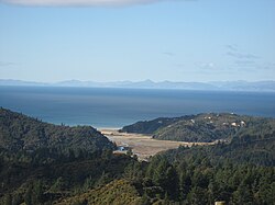
127:
119:
107:
99:
26:
423:, and an increase of 45 people (24.2%) since the
673:. Statistics New Zealand. March 2020. 7022558.
708:
665:
663:
656:2018 Census place summary: Kaiteriteri-Riwaka
419:, an increase of 33 people (16.7%) since the
8:
671:"Statistical area 1 dataset for 2018 Census"
355:
330:
1105:
748:
715:
701:
693:
354:
23:
1745:Populated places in the Tasman District
474:
415:Mārahau had a population of 231 at the
280:
250:
229:
216:
162:
134:
98:
63:
59:
41:
32:
1626:Westhaven (Te Tai Tapu) Marine Reserve
480:
478:
263:
242:
234:
221:
203:
190:
177:
167:
126:
118:
106:
7:
310:and at the southern entrance of the
350:Kaiteriteri-Riwaka statistical area
226:6.14 km (2.37 sq mi)
169: • Territorial Authority
14:
430:Ethnicities were 97.4% European/
46:
34:
1673:Golden Bay-Motueka Rugby Union
461:and 2.6% had other religions.
1:
1412:Rotopōhueroa / Lake Constance
1296:Tokangawhā / Split Apple Rock
21:Place in Tasman, New Zealand
1601:Tonga Island Marine Reserve
1484:Gowanbridge railway station
1474:Brightwater railway station
1407:Rotomairewhenua / Blue Lake
1216:Motuareronui / Adele Island
1075:Dun Mountain-Maitai Terrane
547:(territorial authorities);
16:Town in Tasman, New Zealand
1766:
1539:Nelson Lakes National Park
1440:Facilities and attractions
1402:Pourangahau / Mount Robert
1369:Nelson Lakes National Park
1447:Abel Tasman National Park
1178:Abel Tasman National Park
731:
408:
382:—
312:Abel Tasman National Park
64:
60:
42:
33:
1559:Richmond railway station
1504:Kawatiri railway station
1392:Maniniaro / Angelus Peak
1359:Wharepapa / Arthur Range
486:"ArcGIS Web Application"
1704:Collingwood Area School
1554:Pupu Hydro Power Scheme
1469:Appleby railway station
1324:Ellis Basin cave system
1311:Kahurangi National Park
1291:Moturoa / Rabbit Island
490:statsnz.maps.arcgis.com
455:Māori religious beliefs
417:2018 New Zealand census
173:Tasman District Council
1709:Golden Bay High School
1631:Wharariki Ecosanctuary
1158:Te Waikoropupū Springs
576:"Marahau Travel Guide"
554:Statistics New Zealand
536:Statistics New Zealand
518:Statistics New Zealand
331:
247:44/km (110/sq mi)
84:41.00778°S 173.00889°E
1616:Wai-iti Dark Sky Park
1586:Stoke railway station
1549:Onekaka Power Station
529:(regional councils);
356:Historical population
266: • Summer (
109:Territorial authority
1683:Richmond Athletic FC
1494:Hope railway station
294:is a village in the
244: • Density
194:West Coast-Tasman MP
89:-41.00778; 173.00889
1724:Waimea Intermediate
1714:Motueka High School
1581:St Michael's Church
1570:Rutherford memorial
1058:Geographic features
688:Tourism New Zealand
580:Jasons Travel Media
357:
80: /
1678:New Zealand Energy
1479:Cobb Power Station
1422:Saint Arnaud Range
1110:Golden Bay / Mohua
753:Golden Bay / Mohua
306:. Its location on
236: • Total
223: • Total
1732:
1731:
1611:Tour de Vineyards
1544:Onekaka Ironworks
1524:Motueka Aerodrome
1499:Karamea Aerodrome
1435:
1434:
1427:Spenser Mountains
1053:
1052:
413:
412:
289:
288:
145:West Coast-Tasman
131:Motueka Community
1757:
1591:Tākaka Aerodrome
1519:Milnthorpe Model
1211:Fisherman Island
1106:
749:
745:Populated places
717:
710:
703:
694:
675:
674:
667:
658:
653:
647:
646:
644:
642:
627:
621:
620:
618:
616:
606:"Marahau travel"
602:
596:
595:
593:
591:
586:on 23 March 2012
582:. Archived from
572:
566:
564:
562:
560:
546:
544:
542:
528:
526:
524:
510:
501:
500:
498:
496:
482:
371:
366:
358:
334:
271:
95:
94:
92:
91:
90:
85:
81:
78:
77:
76:
73:
50:
38:
24:
1765:
1764:
1760:
1759:
1758:
1756:
1755:
1754:
1735:
1734:
1733:
1728:
1692:
1656:
1635:
1621:Wangapeka Track
1431:
1363:
1329:Kahurangi Point
1305:
1267:
1186:Armchair Island
1172:
1168:Wharariki Beach
1104:
1049:
1018:Lakes-Murchison
1013:
982:
916:
875:
740:
727:
724:Tasman District
721:
684:
679:
678:
669:
668:
661:
654:
650:
640:
638:
629:
628:
624:
614:
612:
604:
603:
599:
589:
587:
574:
573:
569:
558:
556:
548:
540:
538:
530:
522:
520:
512:
511:
504:
494:
492:
484:
483:
476:
471:
345:
296:Tasman District
265:
207:Te Tai Tonga MP
181:Mayor of Tasman
159:
88:
86:
82:
79:
74:
71:
69:
67:
66:
56:
55:
54:
53:
29:
22:
17:
12:
11:
5:
1763:
1761:
1753:
1752:
1747:
1737:
1736:
1730:
1729:
1727:
1726:
1721:
1719:Waimea College
1716:
1711:
1706:
1700:
1698:
1694:
1693:
1691:
1690:
1688:Talley's Group
1685:
1680:
1675:
1670:
1668:Golden Bay Air
1664:
1662:
1658:
1657:
1655:
1654:
1649:
1643:
1641:
1637:
1636:
1634:
1633:
1628:
1623:
1618:
1613:
1608:
1603:
1598:
1596:Takaka Tramway
1593:
1588:
1583:
1578:
1576:Stafford Place
1573:
1566:
1564:RNZAF Dip Flat
1561:
1556:
1551:
1546:
1541:
1536:
1531:
1526:
1521:
1516:
1511:
1509:Langford Store
1506:
1501:
1496:
1491:
1486:
1481:
1476:
1471:
1466:
1465:
1464:
1459:
1454:
1443:
1441:
1437:
1436:
1433:
1432:
1430:
1429:
1424:
1419:
1414:
1409:
1404:
1399:
1397:Mount Franklin
1394:
1389:
1384:
1379:
1377:Braeburn Range
1373:
1371:
1365:
1364:
1362:
1361:
1356:
1354:Nettlebed Cave
1351:
1346:
1341:
1336:
1331:
1326:
1321:
1315:
1313:
1307:
1306:
1304:
1303:
1298:
1293:
1288:
1283:
1277:
1275:
1269:
1268:
1266:
1265:
1264:
1263:
1253:
1248:
1243:
1238:
1233:
1228:
1223:
1218:
1213:
1208:
1203:
1198:
1193:
1188:
1182:
1180:
1174:
1173:
1171:
1170:
1165:
1160:
1155:
1150:
1145:
1140:
1138:Lake Killarney
1135:
1130:
1125:
1120:
1118:Cobb Reservoir
1114:
1112:
1103:
1102:
1097:
1092:
1087:
1082:
1077:
1072:
1067:
1061:
1059:
1055:
1054:
1051:
1050:
1048:
1047:
1042:
1037:
1032:
1027:
1021:
1019:
1015:
1014:
1012:
1011:
1006:
1001:
996:
994:Aniseed Valley
990:
988:
984:
983:
981:
980:
975:
970:
965:
960:
955:
950:
945:
940:
935:
930:
924:
922:
921:Moutere-Waimea
918:
917:
915:
914:
909:
904:
899:
894:
889:
883:
881:
877:
876:
874:
873:
868:
863:
858:
853:
848:
843:
838:
833:
828:
823:
818:
813:
808:
803:
798:
793:
788:
783:
778:
773:
768:
763:
757:
755:
746:
742:
741:
732:
729:
728:
722:
720:
719:
712:
705:
697:
691:
690:
683:
682:External links
680:
677:
676:
659:
648:
630:Gooch, Carly.
622:
597:
567:
502:
473:
472:
470:
467:
411:
410:
406:
405:
402:
399:
395:
394:
391:
388:
384:
383:
380:
377:
373:
372:
367:
362:
344:
341:
287:
286:
283:
279:
278:
272:
262:
261:
255:
249:
248:
245:
241:
240:
237:
233:
232:
228:
227:
224:
220:
219:
215:
214:
209:
202:
201:
196:
189:
188:
183:
176:
175:
170:
166:
165:
161:
160:
158:
157:
147:
141:
139:
133:
132:
129:
125:
124:
121:
117:
116:
111:
105:
104:
101:
97:
96:
62:
61:
58:
57:
51:
45:
44:
43:
40:
39:
31:
30:
27:
20:
15:
13:
10:
9:
6:
4:
3:
2:
1762:
1751:
1748:
1746:
1743:
1742:
1740:
1725:
1722:
1720:
1717:
1715:
1712:
1710:
1707:
1705:
1702:
1701:
1699:
1695:
1689:
1686:
1684:
1681:
1679:
1676:
1674:
1671:
1669:
1666:
1665:
1663:
1661:Organisations
1659:
1653:
1650:
1648:
1645:
1644:
1642:
1638:
1632:
1629:
1627:
1624:
1622:
1619:
1617:
1614:
1612:
1609:
1607:
1604:
1602:
1599:
1597:
1594:
1592:
1589:
1587:
1584:
1582:
1579:
1577:
1574:
1572:
1571:
1567:
1565:
1562:
1560:
1557:
1555:
1552:
1550:
1547:
1545:
1542:
1540:
1537:
1535:
1532:
1530:
1527:
1525:
1522:
1520:
1517:
1515:
1514:Memorial Park
1512:
1510:
1507:
1505:
1502:
1500:
1497:
1495:
1492:
1490:
1487:
1485:
1482:
1480:
1477:
1475:
1472:
1470:
1467:
1463:
1460:
1458:
1455:
1453:
1450:
1449:
1448:
1445:
1444:
1442:
1438:
1428:
1425:
1423:
1420:
1418:
1417:Sabine Valley
1415:
1413:
1410:
1408:
1405:
1403:
1400:
1398:
1395:
1393:
1390:
1388:
1385:
1383:
1380:
1378:
1375:
1374:
1372:
1370:
1366:
1360:
1357:
1355:
1352:
1350:
1347:
1345:
1344:Mount Burnett
1342:
1340:
1337:
1335:
1332:
1330:
1327:
1325:
1322:
1320:
1319:Bulmer Cavern
1317:
1316:
1314:
1312:
1308:
1302:
1299:
1297:
1294:
1292:
1289:
1287:
1284:
1282:
1279:
1278:
1276:
1274:
1270:
1262:
1259:
1258:
1257:
1254:
1252:
1249:
1247:
1246:Torrent River
1244:
1242:
1239:
1237:
1234:
1232:
1229:
1227:
1224:
1222:
1221:Simonet Creek
1219:
1217:
1214:
1212:
1209:
1207:
1204:
1202:
1199:
1197:
1194:
1192:
1191:Awapoto River
1189:
1187:
1184:
1183:
1181:
1179:
1175:
1169:
1166:
1164:
1161:
1159:
1156:
1154:
1151:
1149:
1146:
1144:
1141:
1139:
1136:
1134:
1133:Harwoods Hole
1131:
1129:
1128:Farewell Spit
1126:
1124:
1121:
1119:
1116:
1115:
1113:
1111:
1107:
1101:
1100:Waimea Plains
1098:
1096:
1093:
1091:
1088:
1086:
1085:Mārahau River
1083:
1081:
1078:
1076:
1073:
1071:
1068:
1066:
1063:
1062:
1060:
1056:
1046:
1043:
1041:
1038:
1036:
1033:
1031:
1028:
1026:
1023:
1022:
1020:
1016:
1010:
1007:
1005:
1002:
1000:
997:
995:
992:
991:
989:
985:
979:
976:
974:
971:
969:
968:Upper Moutere
966:
964:
961:
959:
956:
954:
951:
949:
946:
944:
941:
939:
936:
934:
931:
929:
926:
925:
923:
919:
913:
910:
908:
905:
903:
900:
898:
897:Lower Moutere
895:
893:
890:
888:
885:
884:
882:
878:
872:
869:
867:
864:
862:
859:
857:
854:
852:
849:
847:
844:
842:
839:
837:
834:
832:
829:
827:
824:
822:
819:
817:
814:
812:
809:
807:
804:
802:
799:
797:
794:
792:
789:
787:
784:
782:
779:
777:
774:
772:
769:
767:
764:
762:
759:
758:
756:
754:
750:
747:
743:
739:
735:
730:
726:, New Zealand
725:
718:
713:
711:
706:
704:
699:
698:
695:
689:
686:
685:
681:
672:
666:
664:
660:
657:
652:
649:
637:
633:
626:
623:
611:
610:Lonely Planet
607:
601:
598:
585:
581:
577:
571:
568:
565:(urban areas)
555:
551:
537:
533:
519:
515:
509:
507:
503:
491:
487:
481:
479:
475:
468:
466:
462:
460:
456:
452:
447:
445:
441:
437:
433:
428:
426:
422:
418:
407:
403:
400:
397:
396:
392:
389:
386:
385:
381:
378:
375:
374:
368:
363:
360:
359:
353:
351:
342:
340:
338:
333:
327:
325:
321:
317:
313:
309:
305:
301:
297:
293:
284:
276:
273:
269:
259:
256:
254:
246:
238:
225:
213:
212:Tākuta Ferris
210:
208:
205: •
200:
197:
195:
192: •
187:
184:
182:
179: •
174:
171:
155:
151:
148:
146:
143:
142:
140:
138:
130:
122:
115:
112:
110:
102:
93:
65:Coordinates:
49:
37:
25:
19:
1568:
1489:Heaphy Track
1457:Inland Track
1387:Lake Rotoroa
1382:Lake Rotoiti
1339:Mount Arthur
1301:Waimea Inlet
1256:Wainui River
1241:Tonga Island
1231:Tata Islands
1196:Awaroa River
1153:Tata Islands
1143:Rawhiti Cave
1123:Druggans Dam
1095:Tākaka River
1090:Ngārua Caves
1070:Buller River
1035:Saint Arnaud
901:
861:Upper Tākaka
826:Port Pūponga
651:
639:. Retrieved
635:
625:
613:. Retrieved
609:
600:
588:. Retrieved
584:the original
570:
557:. Retrieved
539:. Retrieved
521:. Retrieved
493:. Retrieved
489:
463:
457:, 1.3% were
448:
429:
414:
346:
343:Demographics
328:
300:South Island
291:
290:
199:Maureen Pugh
150:Te Tai Tonga
123:Motueka Ward
18:
1529:Moutere Inn
1452:Coast Track
1334:Lake Matiri
1286:Best Island
1281:Bell Island
1236:Tinline Bay
1226:Torrent Bay
1206:Falls River
1201:Ballon Rock
1148:Tākaka Hill
1080:Hope Saddle
1065:Brown River
928:Brightwater
892:Kaiteriteri
816:Patons Rock
781:East Tākaka
776:Collingwood
636:Stuff.co.nz
453:, 1.3% had
425:2006 census
421:2013 census
337:Tākaka Hill
137:Electorates
103:New Zealand
87: /
75:173°00′32″E
1739:Categories
1640:Government
1534:Mussel Inn
1349:Mount Owen
1273:Tasman Bay
1163:Wainui Bay
856:Tata Beach
641:5 February
615:5 December
559:25 October
541:25 October
523:25 October
469:References
324:water taxi
308:Tasman Bay
231:Population
164:Government
1251:Tōtaranui
1025:Murchison
978:Woodstock
973:Wakefield
953:Ngātīmoti
836:Rockville
791:Ligar Bay
590:23 August
451:Christian
282:Area code
253:Time zone
128:Community
72:41°0′28″S
1606:Tophouse
1462:Monument
1045:Tophouse
1040:Tapawera
1009:Richmond
987:Richmond
958:Ruby Bay
938:Dovedale
887:Brooklyn
851:Tarakohe
811:Parapara
796:Motupipi
786:Ferntown
738:Richmond
459:Buddhist
440:Pasifika
409:Source:
320:kayaking
316:tramping
186:Tim King
1697:Schools
1647:Council
1030:Rotoroa
999:Appleby
907:Motueka
902:Mārahau
880:Motueka
871:Waitapu
866:Waikato
841:Seaford
831:Pūponga
806:Pākawau
801:Onekaka
771:Clifton
766:Bainham
495:12 July
442:, 1.3%
438:, 1.3%
434:, 5.2%
370:±% p.a.
304:Motueka
298:of the
292:Mārahau
100:Country
28:Mārahau
963:Tasman
943:Mahana
933:Bronte
912:Riwaka
846:Tākaka
821:Pōhara
761:Aorere
432:Pākehā
404:+3.13%
393:+0.90%
332:Te Hau
277:(NZDT)
275:UTC+13
260:(NZST)
258:UTC+12
114:Tasman
1652:Mayor
1261:Falls
948:Māpua
444:Asian
436:Māori
154:Māori
1004:Hope
734:Seat
643:2023
617:2020
592:2011
561:2023
543:2023
525:2023
497:2023
398:2018
387:2013
376:2006
365:Pop.
361:Year
322:and
218:Area
120:Ward
52:Flag
401:231
390:198
379:186
268:DST
239:270
1741::
736::
662:^
634:.
608:.
578:.
552:.
534:.
516:.
505:^
488:.
477:^
352:.
318:,
285:03
716:e
709:t
702:v
645:.
619:.
594:.
563:.
545:.
527:.
499:.
270:)
156:)
152:(
Text is available under the Creative Commons Attribution-ShareAlike License. Additional terms may apply.