385:
397:
373:
40:
350:. Most of the mountain slope is protected land. The mountain is very popular with older climbers, since it can easily be reached by Seoul's public transportation. Annual hiking traffic is close to 5 million people. The Seoul side was designated a city park in 1968.
358:
Seoul
National University Entrance (11.3 km, 4 hours) Siheung-dong (11 km, 3 hours, 30 minutes) Anyang amusement park (12 km, 4 hours, 30 minutes)
384:
396:
503:
Bayer, Achim (2023). "Water, Fire, and the Ascent Above the
Mountain: Symbolism and Its Application in a Buddhist Temple on Mt. Gwan'ak (冠岳山), Seoul".
372:
531:
477:
556:
446:
82:
338:
is located just northwest of the mountain, and the
Gwacheon national government complex lies to the east. Also nearby is the
214:
75:
541:
526:
421:
416:
501:
546:
335:
536:
295:-like profile. Thus Gwanaksan literally means "mountain of the hat-shaped peak". Together with Songaksan in
65:
228:
339:
300:
271:
551:
39:
308:
275:
347:
343:
267:
253:
154:
130:
456:
520:
426:
147:
324:
97:
84:
290:
342:, a popular local tourist attraction. On the mountain itself lie numerous
17:
320:
316:
279:
323:, Gwanaksan was long considered one of the five representative peaks of
312:
296:
219:
204:
201:
198:
174:
158:
55:
274:
districts of Seoul; other portions lie in the neighboring cities of
263:
190:
122:
304:
233:
505:
Kanazawa Seiryo
University Bulletin of the Humanities
227:
213:
189:
173:
168:
146:
141:
129:
118:
113:
74:
64:
54:
49:
32:
8:
257:
196:
180:
289:means "hat-shaped peak," and refers to its
29:
438:
368:
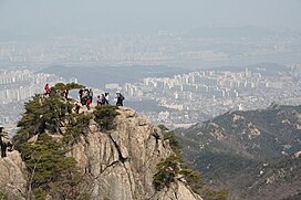
44:People on a peak of the mountain (2007)
402:Yeonju Hermitage on the Gwacheon side
7:
266:, South Korea. Portions lie in the
27:Mountain in south Seoul, South Korea
25:
395:
383:
371:
38:
532:Mountains of Gyeonggi Province
258:
197:
181:
1:
390:Radar equipment on the summit
262:) is a mountain in southern
455:(in Korean). Archived from
234:
220:
573:
422:List of mountains in Korea
417:List of mountains in Seoul
70:632 m (2,073 ft)
60:632 m (2,073 ft)
336:Seoul National University
241:
164:
37:
557:Mountains of South Korea
447:
378:Yeonjudae - the summit
98:37.44556°N 126.96361°E
215:Revised Romanization
346:temples, including
334:The main campus of
103:37.44556; 126.96361
94: /
542:Geumcheon District
527:Mountains of Seoul
340:Anyang Resort Area
272:Geumcheon District
50:Highest point
453:Gwanak-gu website
245:
244:
229:McCune–Reischauer
137:Gwangju Mountains
16:(Redirected from
564:
547:Anyang, Gyeonggi
512:
489:
488:
486:
485:
474:
468:
467:
465:
464:
443:
399:
387:
375:
276:Anyang, Gyeonggi
261:
260:
237:
223:
208:
207:
184:
183:
150:
133:
109:
108:
106:
105:
104:
99:
95:
92:
91:
90:
87:
42:
30:
21:
572:
571:
567:
566:
565:
563:
562:
561:
537:Gwanak District
517:
516:
502:
498:
496:Further reading
493:
492:
483:
481:
476:
475:
471:
462:
460:
449:
445:
444:
440:
435:
413:
408:
407:
406:
403:
400:
391:
388:
379:
376:
364:
356:
268:Gwanak District
209:
185:
148:
131:
102:
100:
96:
93:
88:
85:
83:
81:
80:
45:
28:
23:
22:
15:
12:
11:
5:
570:
568:
560:
559:
554:
549:
544:
539:
534:
529:
519:
518:
515:
514:
497:
494:
491:
490:
469:
437:
436:
434:
431:
430:
429:
424:
419:
412:
409:
405:
404:
401:
394:
392:
389:
382:
380:
377:
370:
367:
366:
365:
363:
360:
355:
352:
243:
242:
239:
238:
231:
225:
224:
217:
211:
210:
195:
193:
187:
186:
179:
177:
171:
170:
166:
165:
162:
161:
155:Gwanak station
152:
144:
143:
139:
138:
135:
127:
126:
120:
116:
115:
111:
110:
78:
72:
71:
68:
62:
61:
58:
52:
51:
47:
46:
43:
35:
34:
26:
24:
14:
13:
10:
9:
6:
4:
3:
2:
569:
558:
555:
553:
550:
548:
545:
543:
540:
538:
535:
533:
530:
528:
525:
524:
522:
513:
510:
506:
500:
499:
495:
479:
473:
470:
459:on 2004-12-07
458:
454:
450:
442:
439:
432:
428:
425:
423:
420:
418:
415:
414:
410:
398:
393:
386:
381:
374:
369:
361:
359:
353:
351:
349:
345:
341:
337:
332:
330:
329:gyeonggi o-ak
326:
322:
318:
314:
310:
306:
302:
298:
294:
293:
288:
283:
281:
277:
273:
269:
265:
255:
251:
250:
240:
236:
232:
230:
226:
222:
218:
216:
212:
206:
203:
200:
194:
192:
188:
178:
176:
172:
167:
163:
160:
156:
153:
151:
149:Easiest route
145:
140:
136:
134:
128:
125:, South Korea
124:
121:
117:
112:
107:
79:
77:
73:
69:
67:
63:
59:
57:
53:
48:
41:
36:
31:
19:
508:
504:
482:. Retrieved
478:"Com Trends"
472:
461:. Retrieved
457:the original
452:
441:
427:Yangjaecheon
357:
333:
328:
291:
286:
284:
248:
247:
246:
132:Parent range
480:(in Korean)
325:Gyeonggi-do
256::
169:Korean name
101: /
89:126°57′49″E
76:Coordinates
521:Categories
484:2010-08-21
463:2006-05-28
433:References
86:37°26′44″N
66:Prominence
18:Mt. Gwanak
285:The name
249:Gwanaksan
235:Kwanaksan
221:Gwanaksan
114:Geography
56:Elevation
33:Gwanaksan
552:Gwacheon
511:: 77–91.
411:See also
348:Wongaksa
344:Buddhist
321:Gapyeong
317:Hwaaksan
301:Gamaksan
280:Gwacheon
142:Climbing
119:Location
362:Gallery
313:Pocheon
297:Kaesong
448:명칭의 유래
354:Trails
315:, and
309:Uaksan
287:gwanak
254:Korean
175:Hangul
159:Anyang
264:Seoul
191:Hanja
123:Seoul
509:7(1)
305:Paju
278:and
270:and
331:).
319:in
311:in
303:in
292:gat
259:관악산
182:관악산
523::
507:.
451:.
307:,
299:,
282:.
157:,
487:.
466:.
327:(
252:(
205:山
202:岳
199:冠
20:)
Text is available under the Creative Commons Attribution-ShareAlike License. Additional terms may apply.