497:. All the district headquarters are the same as the district names (except for Mafinga). There are eight councils in the province, each of which is headed by an elected representative, called councilor. Each councilor holds office for three years. The administrative staff of the council is selected based on Local Government Service Commission from within or outside the district. The office of the provincial government is located in each of the district headquarters and has provincial local government officers and auditors. Each council is responsible for raising and collecting local taxes and the budgets of the council are audited and submitted every year after the annual budget. The elected members of the council do not draw salaries, but are paid allowances from the council. Muchinga is a predominantly rural district and hence there are no city or municipal councils. The government stipulates 63 different functions for the councils with the majority of them being infrastructure management and local administration. Councils are mandated to maintain each of their community centres, zoos, local parks, drainage system, playgrounds, cemeteries, caravan sites, libraries, museums and art galleries. They also work along with specific government departments for helping in agriculture, conservation of natural resources, postal service, establishing and maintaining hospitals, schools and colleges. The councils prepare schemes that encourage community participation.
43:
435:, Muchinga Province had a population of 711,657 accounting to 5.42% of the total Zambian population of 1,3,092,666. There were 349,872 males and 361,785 females, making the sex ratio to 1,034 for every 1,000 males, compared to the national average of 1,028. The literacy rate stood at 63.50% against a national average of 70.2%. The rural population constituted 82.99%, while the urban population was 17.01%. The total area of the province was 87,806 km and the population density was 8.10 per km. The population density during
440:
63.80%. The unemployment rate of the province was 6.40%. The total fertility rate was 7.0, complete birth rate was 6.4, crude birth rate was 40.0, child women population at birth was 854, general fertility rate was 175, gross reproduction rate was 2.8 and net reproduction rate was 2.1. The total labour force constituted 61.90% of the total population. Out of the labour force, 67.9% were men and 56.3% women. The annual growth rate of labour force was 3.6%.
1069:
61:
439:
stood at 8.10. The decadal population growth of the province was 3.10%. The median age in the province at the time of marriage was 20.1. The average household size was 5.1, with the families headed by females being 4.1 and 5.4 for families headed by men. The total eligible voters in the province was
460:
and there are ministries of central government for each province. The administrative head of the province is the
Permanent Secretary, appointed by the President. There is a Deputy Permanent Secretary, heads of government departments and civil servants at the provincial level. Muchinga Province is
660:
664:
359:(no-longer part of Muchinga Province), thereby returning the district to its original province. So, Muchinga Province only has land that was previously part of the Northern Province & currently has
963:
456:
Muchinga is a province formed after 2000 from the existing provinces. Provincial administration is set up purely for administrative purposes. The province is headed by a minister appointed by the
590:
336:
announced the creation of two districts, which were created by splitting Mpika
District into three (north, east and south-west). With Mpika in the east, the two new districts are named
42:
916:(Report). Division for Public Administration and Development Management (DPADM), Department of Economic and Social Affairs (DESA), United Nations. 2004. p. 7
1057:
970:
739:
594:
983:
1050:
572:
686:
1542:
1035:
1807:
1043:
345:
263:
259:
255:
1802:
282:
as the first
Muchinga Province Minister. The parliament approved the creation of the province at some later date.
1610:
1469:
448:
in the province stood at 1,634. The life expectancy at birth stood at 53 compared to the national average of 51.
310:
201:
1698:
1212:
1081:
616:
537:
356:
290:
193:
189:
53:
1459:
486:
322:
910:
711:
1338:
1157:
1109:
935:
212:
1638:
1439:
1348:
494:
224:
1653:
1318:
760:
279:
1683:
1618:
1590:
1585:
1434:
1245:
1235:
1182:
1149:
1139:
1073:
740:"Zambia : President Hichilema to give back Chirundu and Itezhi Districts to Southern Province"
490:
462:
457:
436:
432:
337:
173:
140:
73:
33:
1771:
1716:
1648:
1565:
1512:
1497:
1358:
1265:
1167:
445:
352:
1741:
1678:
1658:
1623:
1580:
1575:
1555:
1517:
1424:
1381:
1328:
1197:
1177:
1162:
1099:
1094:
1089:
661:"Ministry signs contracts for construction of 180 housing units in 17 newly created Districts"
466:
326:
294:
1776:
1766:
1761:
1756:
1668:
1600:
1595:
1570:
1560:
1550:
1502:
1477:
1454:
1444:
1406:
1396:
1386:
1343:
1323:
1313:
1300:
1280:
1260:
1240:
1230:
1220:
1192:
1187:
1134:
553:
533:
521:
482:
474:
314:
306:
251:, in the drainage basin of the Congo. The source of the Luangwa is located in the province.
197:
444:
was the most spoken language with 46.90% speaking it. The total population of persons with
1751:
1746:
1731:
1726:
1721:
1706:
1643:
1633:
1522:
1487:
1482:
1401:
1373:
1363:
1353:
1308:
1275:
1270:
1255:
1250:
1129:
1124:
1119:
549:
244:
223:
The province is elongated from southwest to northeast and is located on both sides of the
1781:
1736:
1711:
1688:
1673:
1663:
1628:
1532:
1527:
1507:
1492:
1449:
1429:
1391:
1333:
1290:
1285:
1225:
1202:
1172:
1114:
1104:
576:
545:
517:
506:
478:
470:
441:
318:
302:
298:
286:
248:
228:
969:(Report). Lusaka: Central Statistical Office, Republic of Zambia. 2012. Archived from
1796:
510:
240:
232:
1020:
341:
275:
333:
236:
998:
985:
687:"Zambia : Creation of new districts is irreversible-President Lungu"
591:"Muchinga the Zambia's 10th province, Choma capital of Southern Province"
516:
A road connecting Kapiri Mposhi and eventually Lusaka with
Tanzania (the
205:
181:
78:
185:
177:
66:
638:
541:
529:
525:
180:. It is located in the northeast of the country and borders with
941:(Report). Common Wealth Local Government Forum. pp. 218–220
513:
with
Tanzania crosses the province from southwest to northeast.
385:
1039:
204:
in the northwest. The administrative center of the province is
380:
254:
Three national parks are located in the province. There are
278:
in
October 2011. In November 2011, the president appointed
266:. The latter is shared with Eastern and Central Provinces.
227:(Muchinga Escarpment), which serve as a divide between the
239:(Atlantic Ocean). The main rivers of the province are the
154:
274:
The creation of a province was announced by
President
285:
The province consisted originally of five districts.
663:. Ministry Of Local Government. 2013. Archived from
1697:
1609:
1541:
1468:
1415:
1372:
1299:
1211:
1148:
1080:
348:), bringing the total number of districts to nine.
329:, bringing the total number of districts to seven.
149:
139:
131:
123:
118:
110:
105:
97:
89:
84:
72:
52:
24:
243:, a major left tributary of the Zambezi, and the
964:Summary report for the 2010 Census of population
617:"Sata appoints minister for 'Muchinga' province"
355:officially declared Chama District as part of
1051:
593:. UKZambians. 15 October 2011. Archived from
211:The name of the province originates from the
8:
371:
911:Zambi Public administration Country profile
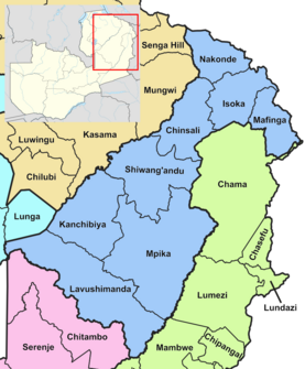
47:Map of Zambia showing the Muchinga Province
1058:
1044:
1036:
370:
21:
1021:"Zambia map showing the province borders"
564:
544:, another major road branches north to
148:
138:
117:
114:87,806 km (33,902 sq mi)
104:
83:
71:
51:
39:
344:(south-west of Mpika; named after the
936:The local government system in Zambia
712:"Pres. Lungu Creates 3 New Districts"
619:. Zambian Watchdog. November 27, 2011
524:) runs through the province, passing
130:
122:
109:
96:
88:
7:
734:
732:
360:
536:) (this road is also known as the
215:, on which it predominantly sits.
14:
1067:
98: • Provincial Minister
59:
41:
351:On 17 November 2021, President
761:"Lusaka Population, 1969-2010"
1:
765:zambia.opendataforafrica.org
897:
885:
873:
861:
849:
837:
825:
813:
801:
789:
777:
346:Lavushi Manda National Park
264:South Luangwa National Park
260:North Luangwa National Park
256:Lavushi Manda National Park
1824:
309:were transferred from the
424:
398:—
325:was created by splitting
317:was created by splitting
289:was transferred from the
93:Provincial Administration
40:
31:
235:(Indian Ocean) and the
1543:North-Western Province
639:"Provinces of Zambia"
573:"Muchinga Escarpment"
495:Lavushimanda District
487:Shiwang'andu District
372:Historical population
342:Lavushimanda District
340:(north of Mpika) and
323:Shiwang'andu District
135:11/km (27/sq mi)
132: • Density
101:Henry Sikazwe (UPND)
1808:Provinces of Zambia
1150:Copperbelt Province
1074:Districts of Zambia
995: /
491:Kanchibiya District
461:divided into eight
437:2000 Zambian census
433:2010 Zambian census
373:
338:Kanchibiya District
332:In 2017, President
213:Muchinga Escarpment
742:. 18 November 2021
353:Hakainde Hichilema
225:Muchinga Mountains
196:in the southwest,
172:is one of the ten
124: • Total
111: • Total
19:Province in Zambia
16:Province of Zambia
1803:Muchinga Province
1790:
1789:
1611:Southern Province
1470:Northern Province
1417:Muchinga Province
1023:. Thomas Brinkhof
999:10.000°S 32.000°E
667:on 2 October 2013
509:, which connects
467:Chinsali District
429:
428:
327:Chinsali District
311:Northern Province
307:Nakonde Districts
247:, a tributary of
202:Northern Province
200:in the west, and
170:Muchinga Province
167:
166:
90: • Type
1815:
1699:Western Province
1301:Luapula Province
1213:Eastern Province
1082:Central Province
1072:
1071:
1070:
1060:
1053:
1046:
1037:
1032:
1030:
1028:
1010:
1009:
1007:
1006:
1005:
1000:
996:
993:
992:
991:
988:
977:
975:
968:
951:
950:
948:
946:
940:
932:
926:
925:
923:
921:
915:
907:
901:
895:
889:
883:
877:
871:
865:
859:
853:
847:
841:
835:
829:
823:
817:
811:
805:
799:
793:
787:
781:
775:
769:
768:
757:
751:
750:
748:
747:
736:
727:
726:
724:
723:
708:
702:
701:
699:
698:
683:
677:
676:
674:
672:
657:
651:
650:
648:
646:
635:
629:
628:
626:
624:
613:
607:
606:
604:
602:
587:
581:
580:
575:. Archived from
569:
538:Great North Road
483:Nakonde District
475:Mafinga District
387:
382:
374:
357:Eastern Province
315:Mafinga District
291:Eastern Province
198:Luapula Province
194:Central Province
190:Eastern Province
163:
160:
158:
156:
65:
63:
62:
45:
22:
1823:
1822:
1818:
1817:
1816:
1814:
1813:
1812:
1793:
1792:
1791:
1786:
1693:
1605:
1537:
1464:
1411:
1374:Lusaka Province
1368:
1295:
1207:
1144:
1076:
1068:
1066:
1064:
1026:
1024:
1019:
1016:
1004:-10.000; 32.000
1003:
1001:
997:
994:
989:
986:
984:
982:
981:
973:
966:
962:
959:
954:
944:
942:
938:
934:
933:
929:
919:
917:
913:
909:
908:
904:
896:
892:
884:
880:
872:
868:
860:
856:
848:
844:
836:
832:
824:
820:
812:
808:
800:
796:
788:
784:
776:
772:
759:
758:
754:
745:
743:
738:
737:
730:
721:
719:
710:
709:
705:
696:
694:
691:LusakaTimes.com
685:
684:
680:
670:
668:
659:
658:
654:
644:
642:
637:
636:
632:
622:
620:
615:
614:
610:
600:
598:
597:on 4 March 2016
589:
588:
584:
571:
570:
566:
562:
550:Lake Tanganyika
532:(and bypassing
503:
454:
369:
272:
245:Chambeshi River
229:drainage basins
221:
153:
60:
58:
48:
36:
27:
20:
17:
12:
11:
5:
1821:
1819:
1811:
1810:
1805:
1795:
1794:
1788:
1787:
1785:
1784:
1779:
1774:
1769:
1764:
1759:
1754:
1749:
1744:
1739:
1734:
1729:
1724:
1719:
1714:
1709:
1703:
1701:
1695:
1694:
1692:
1691:
1686:
1681:
1676:
1671:
1666:
1661:
1656:
1651:
1646:
1641:
1636:
1631:
1626:
1621:
1615:
1613:
1607:
1606:
1604:
1603:
1598:
1593:
1588:
1583:
1578:
1573:
1568:
1563:
1558:
1553:
1547:
1545:
1539:
1538:
1536:
1535:
1530:
1525:
1520:
1515:
1510:
1505:
1500:
1495:
1490:
1485:
1480:
1474:
1472:
1466:
1465:
1463:
1462:
1457:
1452:
1447:
1442:
1437:
1432:
1427:
1421:
1419:
1413:
1412:
1410:
1409:
1404:
1399:
1394:
1389:
1384:
1378:
1376:
1370:
1369:
1367:
1366:
1361:
1356:
1351:
1346:
1341:
1336:
1331:
1326:
1321:
1316:
1311:
1305:
1303:
1297:
1296:
1294:
1293:
1288:
1283:
1278:
1273:
1268:
1263:
1258:
1253:
1248:
1243:
1238:
1233:
1228:
1223:
1217:
1215:
1209:
1208:
1206:
1205:
1200:
1195:
1190:
1185:
1180:
1175:
1170:
1165:
1160:
1154:
1152:
1146:
1145:
1143:
1142:
1137:
1132:
1127:
1122:
1117:
1112:
1107:
1102:
1097:
1092:
1086:
1084:
1078:
1077:
1065:
1063:
1062:
1055:
1048:
1040:
1034:
1033:
1015:
1014:External links
1012:
979:
978:
976:on 2015-10-26.
958:
955:
953:
952:
927:
902:
890:
878:
866:
854:
842:
830:
818:
806:
794:
782:
770:
752:
728:
716:Zambia Reports
703:
678:
652:
630:
608:
582:
579:on 2019-04-16.
563:
561:
558:
518:Tanzam Highway
507:TAZARA Railway
502:
501:Transportation
499:
479:Mpika District
471:Isoka District
453:
452:Administration
450:
427:
426:
422:
421:
418:
415:
411:
410:
407:
404:
400:
399:
396:
393:
389:
388:
383:
378:
368:
365:
319:Isoka District
287:Chama District
280:Malozo Sichone
271:
268:
249:Lake Bangweulu
220:
217:
192:in the south,
184:in the north,
165:
164:
151:
147:
146:
143:
137:
136:
133:
129:
128:
125:
121:
120:
116:
115:
112:
108:
107:
103:
102:
99:
95:
94:
91:
87:
86:
82:
81:
76:
70:
69:
56:
50:
49:
46:
38:
37:
32:
29:
28:
25:
18:
15:
13:
10:
9:
6:
4:
3:
2:
1820:
1809:
1806:
1804:
1801:
1800:
1798:
1783:
1780:
1778:
1775:
1773:
1770:
1768:
1765:
1763:
1760:
1758:
1755:
1753:
1750:
1748:
1745:
1743:
1740:
1738:
1735:
1733:
1730:
1728:
1725:
1723:
1720:
1718:
1715:
1713:
1710:
1708:
1705:
1704:
1702:
1700:
1696:
1690:
1687:
1685:
1682:
1680:
1677:
1675:
1672:
1670:
1667:
1665:
1662:
1660:
1657:
1655:
1652:
1650:
1647:
1645:
1642:
1640:
1637:
1635:
1632:
1630:
1627:
1625:
1622:
1620:
1617:
1616:
1614:
1612:
1608:
1602:
1599:
1597:
1594:
1592:
1589:
1587:
1584:
1582:
1579:
1577:
1574:
1572:
1569:
1567:
1564:
1562:
1559:
1557:
1554:
1552:
1549:
1548:
1546:
1544:
1540:
1534:
1531:
1529:
1526:
1524:
1521:
1519:
1516:
1514:
1511:
1509:
1506:
1504:
1501:
1499:
1496:
1494:
1491:
1489:
1486:
1484:
1481:
1479:
1476:
1475:
1473:
1471:
1467:
1461:
1460:Shiwa Ng'andu
1458:
1456:
1453:
1451:
1448:
1446:
1443:
1441:
1438:
1436:
1433:
1431:
1428:
1426:
1423:
1422:
1420:
1418:
1414:
1408:
1405:
1403:
1400:
1398:
1395:
1393:
1390:
1388:
1385:
1383:
1380:
1379:
1377:
1375:
1371:
1365:
1362:
1360:
1357:
1355:
1352:
1350:
1347:
1345:
1342:
1340:
1337:
1335:
1332:
1330:
1327:
1325:
1322:
1320:
1317:
1315:
1312:
1310:
1307:
1306:
1304:
1302:
1298:
1292:
1289:
1287:
1284:
1282:
1279:
1277:
1274:
1272:
1269:
1267:
1264:
1262:
1259:
1257:
1254:
1252:
1249:
1247:
1244:
1242:
1239:
1237:
1234:
1232:
1229:
1227:
1224:
1222:
1219:
1218:
1216:
1214:
1210:
1204:
1201:
1199:
1196:
1194:
1191:
1189:
1186:
1184:
1181:
1179:
1176:
1174:
1171:
1169:
1166:
1164:
1161:
1159:
1158:Chililabombwe
1156:
1155:
1153:
1151:
1147:
1141:
1138:
1136:
1133:
1131:
1128:
1126:
1123:
1121:
1118:
1116:
1113:
1111:
1110:Kapiri Mposhi
1108:
1106:
1103:
1101:
1098:
1096:
1093:
1091:
1088:
1087:
1085:
1083:
1079:
1075:
1061:
1056:
1054:
1049:
1047:
1042:
1041:
1038:
1022:
1018:
1017:
1013:
1011:
1008:
972:
965:
961:
960:
956:
937:
931:
928:
912:
906:
903:
899:
894:
891:
887:
882:
879:
875:
870:
867:
863:
858:
855:
851:
846:
843:
839:
834:
831:
827:
822:
819:
815:
810:
807:
803:
798:
795:
791:
786:
783:
779:
774:
771:
766:
762:
756:
753:
741:
735:
733:
729:
717:
713:
707:
704:
692:
688:
682:
679:
666:
662:
656:
653:
640:
634:
631:
618:
612:
609:
596:
592:
586:
583:
578:
574:
568:
565:
559:
557:
555:
551:
547:
543:
539:
535:
531:
527:
523:
519:
514:
512:
511:Kapiri Mposhi
508:
500:
498:
496:
492:
488:
484:
480:
476:
472:
468:
464:
459:
451:
449:
447:
443:
438:
434:
423:
419:
416:
413:
412:
408:
405:
402:
401:
397:
394:
391:
390:
384:
379:
376:
375:
366:
364:
362:
358:
354:
349:
347:
343:
339:
335:
330:
328:
324:
320:
316:
312:
308:
304:
300:
296:
292:
288:
283:
281:
277:
269:
267:
265:
261:
257:
252:
250:
246:
242:
241:Luangwa River
238:
234:
233:Zambezi River
230:
226:
218:
216:
214:
209:
207:
203:
199:
195:
191:
188:in the east,
187:
183:
179:
175:
171:
162:
152:
144:
142:
134:
126:
113:
100:
92:
80:
77:
75:
68:
57:
55:
44:
35:
30:
23:
1639:Itezhi-Tezhi
1440:Lavushimanda
1416:
1349:Mwansabombwe
1025:. Retrieved
980:
971:the original
943:. Retrieved
930:
918:. Retrieved
905:
893:
881:
869:
857:
845:
833:
821:
809:
797:
785:
773:
764:
755:
744:. Retrieved
720:. Retrieved
718:. 2017-03-05
715:
706:
695:. Retrieved
693:. 2018-01-22
690:
681:
669:. Retrieved
665:the original
655:
643:. Retrieved
633:
621:. Retrieved
611:
599:. Retrieved
595:the original
585:
577:the original
567:
515:
504:
455:
430:
367:Demographics
350:
331:
284:
276:Michael Sata
273:
253:
222:
210:
169:
168:
1654:Livingstone
1319:Chifunabuli
1027:23 December
1002: /
898:Census 2012
886:Census 2012
874:Census 2012
862:Census 2012
850:Census 2012
838:Census 2012
826:Census 2012
816:, pp. 12-13
814:Census 2012
802:Census 2012
790:Census 2012
778:Census 2012
671:21 December
645:21 December
623:21 December
601:21 December
431:As per the
361:8 districts
334:Edgar Lungu
313:. In 2013,
237:Congo River
1797:Categories
1684:Sinazongwe
1619:Chikankata
1591:Mwinilunga
1586:Mushindano
1435:Kanchibiya
1246:Kasenengwa
1236:Chipangali
1183:Lufwanyama
1140:Shibuyunji
957:References
945:16 October
920:16 October
746:2021-11-18
722:2019-04-22
697:2019-04-22
641:. Statoids
293:, and the
119:Population
85:Government
1772:Shangombo
1717:Limulunga
1649:Kazungula
1566:Kalumbila
1513:Mporokoso
1498:Lupososhi
1359:Nchelenge
1266:Lusangazi
1168:Kalulushi
465:, namely
463:districts
458:President
219:Geography
174:provinces
141:Districts
1742:Mulobezi
1679:Siavonga
1659:Mazabuka
1624:Chirundu
1581:Mufumbwe
1576:Manyinga
1556:Ikelenge
1518:Mpulungu
1425:Chinsali
1382:Chilanga
1329:Kawambwa
1198:Mufulira
1178:Luanshya
1163:Chingola
1100:Chitambo
1095:Chisamba
1090:Chibombo
554:M1 Route
534:Chinsali
522:T2 Route
446:Albinism
295:Chinsali
206:Chinsali
182:Tanzania
79:Chinsali
34:Province
26:Muchinga
1777:Sikongo
1767:Sesheke
1762:Senanga
1757:Nkeyema
1669:Namwala
1601:Zambezi
1596:Solwezi
1571:Kasempa
1561:Kabompo
1551:Chavuma
1503:Luwingu
1478:Chilubi
1455:Nakonde
1445:Mafinga
1407:Rufunsa
1397:Luangwa
1387:Chongwe
1344:Milenge
1324:Chipili
1314:Chiengi
1281:Petauke
1261:Lundazi
1241:Chipata
1231:Chasefu
1221:Chadiza
1193:Mpongwe
1188:Masaiti
1135:Serenje
990:32°00′E
987:10°00′S
900:, p. 74
888:, p. 78
876:, p. 99
864:, p. 93
852:, p. 44
840:, p. 21
828:, p. 19
804:, p. 17
792:, p. 24
425:Source:
417:922,212
406:711,657
395:566,266
270:History
231:of the
150:Website
127:922,212
74:Capital
54:Country
1752:Nalolo
1747:Mwandi
1732:Mitete
1727:Lukulu
1722:Luampa
1707:Kalabo
1644:Kalomo
1634:Gwembe
1523:Mungwi
1488:Kasama
1483:Kaputa
1402:Lusaka
1364:Samfya
1354:Mwense
1309:Chembe
1276:Nyimba
1271:Mambwe
1256:Lumezi
1251:Katete
1130:Ngabwe
1125:Mumbwa
1120:Mkushi
780:, p. 7
546:Kasama
540:). In
520:; the
420:+29.6%
409:+25.7%
305:, and
262:, and
186:Malawi
178:Zambia
67:Zambia
64:
1782:Sioma
1737:Mongu
1712:Kaoma
1689:Zimba
1674:Pemba
1664:Monze
1629:Choma
1533:Senga
1528:Nsama
1508:Mbala
1493:Lunte
1450:Mpika
1430:Isoka
1392:Kafue
1339:Mansa
1334:Lunga
1291:Vubwi
1286:Sinda
1226:Chama
1203:Ndola
1173:Kitwe
1115:Luano
1105:Kabwe
974:(PDF)
967:(PDF)
939:(PDF)
914:(PDF)
560:Notes
552:(the
542:Mpika
530:Isoka
526:Mpika
442:Bemba
303:Mpika
299:Isoka
1029:2013
947:2016
922:2016
673:2013
647:2013
625:2013
603:2013
548:and
528:and
505:The
493:and
414:2022
403:2010
392:2000
381:Pop.
377:Year
321:and
159:.gov
157:.muc
106:Area
556:).
176:of
161:.zm
155:www
1799::
763:.
731:^
714:.
689:.
489:,
485:,
481:,
477:,
473:,
469:,
386:±%
363:.
301:,
297:,
258:,
208:.
1059:e
1052:t
1045:v
1031:.
949:.
924:.
767:.
749:.
725:.
700:.
675:.
649:.
627:.
605:.
145:7
Text is available under the Creative Commons Attribution-ShareAlike License. Additional terms may apply.