258:
42:
332:(917 metres) which is listed as a "top" in Munro's Tables. The South East Top was previously called "Coire Dearg Top" but was changed to avoid confusion as the main summit also overlooks Coire Dearg. The other two northern corries are smaller: Coire Riabhach also drains to Glen Nevis while Coire a’ Mhuillinn empties further west into the River Kiachnish which delineates the mountain's western boundary. A fourth corrie, Coire Carach stands on the mountain's southern slopes.
639:
599:
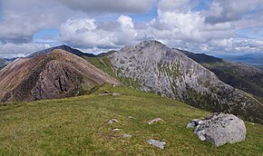
328:. Mullach nan Coirean is a large sprawling mountain of ridges and corries, with its granite rock giving it a red shade (see picture). The mountain has three north-facing corries: the finest of these is Coire Dearg (Red Corrie) which is drained by the Allt a' Choire Dheirg into Glen Nevis and is overlooked by Mullach nan Coirean’s
360:
Mullach nan
Coirean is often climbed together with the neighbouring Stob Bàn; this walk starts at Achriabhach and climbs Coire a' Mhusgain before crossing Stob Bàn to reach Mullach nan Coirean. A direct ascent of the mountain starts at the same place and goes through the Nevis Forest to reach Mullach
335:
Mullach nan
Coirean has four ridges radiating from its summit. The eastern ridge links to the adjoining Munro of Stob Bàn, which is three kilometres away, whilst the south western ridge links to the subsidiary top of Meall a' Chaorainn (910 metres) before descending steeply to the glen of the River
352:) to the west coast. The northeast ridge also descends to Glen Nevis but is much shorter. The mountain's lower northern slopes are covered by the coniferous woodland of the Nevis Forest.
882:
877:
225:
257:
567:
41:
108:
560:
853:
324:
Mullach nan
Coirean stands in stark contrast to the adjoining Stob Bàn, which is a pointed and light-shaded peak, owing to its crown of
553:
399:
389:
379:
304:
in the
Mamores. It has a lower peak to the west, Meall a' Chaorainn (910 m). To the east, it is linked to the neighbouring mountain
170:
219:
340:
of Dùn
Deardail ("Fort of the Red Eye") near its end, just before it joins Glen Nevis. The fort is probably named after
101:
832:
361:
nan
Coirean’s northeast ridge which is ascended to the summit. The top of the mountain is an excellent place to view
720:
697:
479:
791:
277:
162:
148:
796:
817:
776:
751:
194:
687:
842:
584:
77:
67:
730:
464:"The High Mountains of Britain and Ireland" Pages 88 (Gives Gaelic translation as "Top of the Corries").
766:
692:
682:
305:
82:
735:
725:
628:
781:
771:
545:
474:
297:
89:
837:
395:
385:
375:
419:
872:
677:
506:
245:
238:
233:
300:. It reaches a height of 939 metres (3081 feet) and is the most westerly of the ten
672:
337:
205:
866:
786:
616:
309:
638:
509:
Spreadsheet giving details of changes through successive editions of Munro's Tables.
827:
812:
761:
712:
667:
662:
348:, and is one in a line of vitrified forts that stretches from Craig Phàdraig (near
443:
611:
588:
527:
362:
598:
822:
518:"Hamish's Mountain Walk" Page 166 (Gives info on Dùn Deardail vitrified fort).
313:
494:
123:
110:
756:
657:
622:
455:"The Munros" Page 69 (Gives Gaelic translation as "Summit of the Corries") .
349:
325:
312:
at a height of 846 metres; these two Munros are often climbed together from
580:
198:
649:
341:
293:
212:
345:
281:
57:
576:
374:
The Munros: Donald
Bennett et al.: Scottish Mountaineering Trust:
336:
Kiachnish. The northern ridge is four kilometres long and has the
301:
289:
256:
94:
549:
637:
539:
384:
100 Best Routes on
Scottish Mountains, Ralph Storer,
269:
171:
29:
805:
744:
711:
648:
604:
497:
232:
218:
204:
190:
185:
154:
144:
139:
100:
88:
76:
66:
56:
51:
23:
883:Mountains and hills of Highland (council area)
561:
8:
878:Mountains and hills of the Central Highlands
568:
554:
546:
20:
854:List of Munros and Munro Tops in Scotland
439:
437:
411:
394:Hamish’s Mountain Walk, Hamish Brown,
46:Mullach nan Coirean seen from Stob Bàn
161:
7:
444:Database of British and Irish Hills.
420:"walkhighlands Mullach nan Coirean"
14:
597:
482:: Gaelic Place-Names of Scotland
40:
530:Gives further details of fort.
507:The Munros and Tops 1891-1997.
1:
163:[ˈmul̪ˠəxnəŋˈkʰɔɾʲən]
422:. walkhighlands.co.uk. 2013
899:
62:939 m (3,081 ft)
851:
635:
595:
39:
28:
833:Stob a' Choire Mheadhoin
797:Mullach Coire an Iubhair
528:The Modern Antiquarian.
280:for 'summit of the
72:93 m (305 ft)
642:
480:Ainmean-Àite na h-Alba
446:Retrieved 21 Jan 2012.
270:
266:
168:English approximation:
124:56.749867°N 5.072397°W
30:
641:
475:"Mullach nan Coirean"
260:
843:Stob Coire Sgriodain
736:Stob Coire an Laoigh
726:Stob Choire Claurigh
698:Stob Coire a' Chàirn
261:Mullach nan Coirean
129:56.749867; -5.072397
16:Mountain in Scotland
731:Sgùrr Choinnich Mòr
703:Mullach nan Coirean
272:Mullach nan Coirean
120: /
24:Mullach nan Coirean
767:Beinn a' Chlachair
643:
344:, the princess of
298:Scottish Highlands
286:Sgùrr a' Chaorainn
267:
52:Highest point
32:Sgùrr a' Chaorainn
860:
859:
838:Stob Coire Easain
296:mountains in the
292:') is one of the
255:
254:
169:
890:
745:Alder/Ardverikie
601:
570:
563:
556:
547:
540:
537:
531:
525:
519:
516:
510:
504:
498:
492:
486:
485:
471:
465:
462:
456:
453:
447:
441:
432:
431:
429:
427:
416:
275:
228:
208:
178:
174:
167:
165:
160:
159:Scottish Gaelic:
145:Language of name
135:
134:
132:
131:
130:
125:
121:
118:
117:
116:
113:
44:
35:
21:
898:
897:
893:
892:
891:
889:
888:
887:
863:
862:
861:
856:
847:
801:
740:
707:
683:Sgùrr Eilde Mòr
678:Na Gruagaichean
644:
633:
602:
591:
574:
544:
543:
538:
534:
526:
522:
517:
513:
505:
501:
493:
489:
473:
472:
468:
463:
459:
454:
450:
442:
435:
425:
423:
418:
417:
413:
371:
358:
322:
278:Scottish Gaelic
224:
206:
176:
172:
166:
158:
149:Scottish Gaelic
128:
126:
122:
119:
114:
111:
109:
107:
106:
47:
17:
12:
11:
5:
896:
894:
886:
885:
880:
875:
865:
864:
858:
857:
852:
849:
848:
846:
845:
840:
835:
830:
825:
820:
815:
809:
807:
803:
802:
800:
799:
794:
789:
784:
779:
774:
769:
764:
759:
754:
748:
746:
742:
741:
739:
738:
733:
728:
723:
717:
715:
709:
708:
706:
705:
700:
695:
690:
688:Sgùrr a' Mhàim
685:
680:
675:
670:
665:
660:
654:
652:
646:
645:
636:
634:
632:
631:
629:Càrn Mòr Dearg
626:
619:
614:
608:
606:
603:
596:
593:
592:
575:
573:
572:
565:
558:
550:
542:
541:
532:
520:
511:
499:
487:
466:
457:
448:
433:
410:
409:
403:
402:
392:
382:
370:
367:
357:
354:
338:vitrified fort
330:South East Top
321:
318:
288:('peak of the
253:
252:
236:
230:
229:
222:
216:
215:
210:
202:
201:
192:
188:
187:
183:
182:
156:
152:
151:
146:
142:
141:
137:
136:
104:
98:
97:
92:
86:
85:
80:
74:
73:
70:
64:
63:
60:
54:
53:
49:
48:
45:
37:
36:
26:
25:
15:
13:
10:
9:
6:
4:
3:
2:
895:
884:
881:
879:
876:
874:
871:
870:
868:
855:
850:
844:
841:
839:
836:
834:
831:
829:
826:
824:
821:
819:
816:
814:
811:
810:
808:
804:
798:
795:
793:
790:
788:
785:
783:
782:Creag Pitridh
780:
778:
775:
773:
772:Beinn Eibhinn
770:
768:
765:
763:
760:
758:
755:
753:
750:
749:
747:
743:
737:
734:
732:
729:
727:
724:
722:
719:
718:
716:
714:
710:
704:
701:
699:
696:
694:
691:
689:
686:
684:
681:
679:
676:
674:
671:
669:
666:
664:
661:
659:
656:
655:
653:
651:
647:
640:
630:
627:
625:
624:
620:
618:
615:
613:
610:
609:
607:
600:
594:
590:
586:
582:
578:
571:
566:
564:
559:
557:
552:
551:
548:
536:
533:
529:
524:
521:
515:
512:
508:
503:
500:
496:
491:
488:
483:
481:
476:
470:
467:
461:
458:
452:
449:
445:
440:
438:
434:
421:
415:
412:
408:
407:
401:
400:1-898573-08-5
397:
393:
391:
390:0-7515-0300-2
387:
383:
381:
380:0-907521-13-4
377:
373:
372:
368:
366:
364:
355:
353:
351:
347:
343:
339:
333:
331:
327:
319:
317:
315:
311:
307:
303:
299:
295:
291:
287:
283:
279:
274:
273:
264:
259:
250:
247:
243:
240:
237:
235:
231:
227:
223:
221:
217:
214:
211:
209:
203:
200:
196:
193:
189:
184:
181:
180:
164:
157:
155:Pronunciation
153:
150:
147:
143:
138:
133:
105:
103:
99:
96:
93:
91:
87:
84:
81:
79:
75:
71:
69:
65:
61:
59:
55:
50:
43:
38:
34:
33:
27:
22:
19:
828:Sgor Gaibhre
813:Beinn na Lap
806:Ossian/Treig
762:Beinn Bheòil
713:Grey Corries
702:
668:Binnein Beag
663:An Gearanach
621:
585:Fort William
535:
523:
514:
502:
495:Munro Magic.
490:
478:
469:
460:
451:
424:. Retrieved
414:
405:
404:
359:
334:
329:
323:
285:
271:
268:
265:and Stob Ban
262:
248:
241:
207:Parent range
31:
18:
752:Aonach Beag
673:Binnein Mòr
612:Aonach Beag
605:Nevis range
589:Loch Ericht
426:25 November
363:Loch Linnhe
127: /
102:Coordinates
78:Parent peak
867:Categories
823:Chno Dearg
818:Càrn Dearg
792:Geal Charn
787:Geal-Chàrn
777:Càrn Dearg
617:Aonach Mòr
369:References
314:Glen Nevis
284:') or
242:Landranger
175:-ləkh-nən-
112:56°45′00″N
68:Prominence
757:Ben Alder
658:Am Bodach
623:Ben Nevis
406:Footnotes
350:Inverness
326:quartzite
320:Landscape
249:Explorers
186:Geography
115:5°04′21″W
58:Elevation
721:Stob Bàn
693:Stob Bàn
581:Scotland
356:Climbing
306:Stob Bàn
234:Topo map
226:NN122662
199:Scotland
195:Highland
191:Location
83:Stob Bàn
650:Mamores
342:Deirdre
310:bealach
294:Mamores
282:corries
220:OS grid
213:Mamores
90:Listing
873:Munros
577:Munros
398:
388:
378:
346:Ulster
302:Munros
263:(left)
140:Naming
308:by a
290:rowan
95:Munro
428:2013
396:ISBN
386:ISBN
376:ISBN
244:41,
179:-yən
587:to
579:of
251:392
177:KOR
173:MOO
869::
583::
477:.
436:^
365:.
316:.
246:OS
239:OS
197:,
569:e
562:t
555:v
484:.
430:.
276:(
Text is available under the Creative Commons Attribution-ShareAlike License. Additional terms may apply.