66:
884:, the largest meteorite found in Australia, weighing 12.4 tonnes (12.2 long tons; 13.7 short tons), was found by geologists R.B. Wilson and A.M. Cooney during a geological survey at Mundrabilla in 1966, and forms one half of the "Mundrabilla Mass". The next largest fragment weighs 5.08 tonnes (5.00 long tons; 5.60 short tons). In all, 22 tonnes (22 long tons; 24 short tons) of fragments have been recovered, spread over a 60 km (37 mi) range making it one of the largest meteorite sites in the world. The fragments fell to Earth at least one million years ago.
50:
970:
936:
383:), the first sheep station in the Nullarbor region, was established by William Stuart McGill (a Scotsman) and Thomas and William Kennedy (two Irishmen) in 1872. Thomas Kennedy died in 1896. McGill's first wife Annie Harkness (née Crawford) died in childbirth in 1879. Annie McGill and Thomas Kennedy are both buried on Mundrabilla Station. McGill remarried Ellen Angel Fairweather of Adelaide in 1889.
1107:
73:
395:; however it is cooler in summer than much of the Australian desert due to its proximity to the ocean. Despite this, Mundrabilla Station still holds the record for the equal 6th-hottest temperature in Australia, 49.8 °C (121.6 °F) recorded on 3 January 1979.
234:
222:
102:
65:
1052:
210:
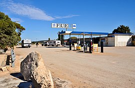
872:, open 6:00am to 9:30pm each day. The roadhouse includes a small wildlife park with emus, camels and an aviary. Pastoral activities continue in the area.
1381:
1151:
893:
300:. The two significant features are Mundrabilla Roadhouse and Mundrabilla Station, which are approximately 35 kilometres (22 mi) apart. At the
996:
1111:
355:
1077:
1366:
850:
935:
948:
913:
316:
Mundrabilla
Roadhouse was built by Roger and Pat Warren-Langford, who initially managed Mundrabilla Station. It is now a small
1195:
1185:
1144:
1280:
95:
1295:
1290:
1180:
195:
1391:
1340:
1300:
1285:
1275:
1235:
1190:
227:
1305:
1200:
1376:
1371:
1335:
1316:
1266:
1245:
1210:
1137:
337:
201:
1330:
1255:
1250:
1240:
881:
239:
1345:
952:
917:
341:
301:
157:
141:
1386:
1325:
1030:
982:
869:
317:
1129:
1022:
49:
1081:
325:
297:
40:
1161:
865:
333:
215:
1123:
969:
1230:
304:, Mundrabilla had a population of 23, 32% male and 68% female. The time zone in use is
1360:
1221:
1171:
392:
321:
17:
1118:
329:
305:
370:
357:
117:
104:
1106:
189:
1133:
296:
is in a very sparsely populated area in the far south east of
1078:"Solar System information #6: Meteors and Meteorites"
1053:"Mundrabilla iron meteorite (main mass 12.4 tonnes)"
1314:
1264:
1219:
1169:
233:
221:
209:
182:
174:
166:
156:
148:
133:
94:
34:
340:and about 20 kilometres (12 mi) north of the
246:
868:area, the area consists of nothing more than a
1080:. Perth Observatory. 1997–2009. Archived from
1145:
8:
1119:Shire of Dundas – Towns of the Eyre Highway
1027:Climate statistics for Australian locations
138:
1152:
1138:
1130:
968:
934:
399:
48:
31:
894:List of extreme temperatures in Australia
905:
336:), 66 kilometres (41 mi) west of
403:Climate data for Mundrabilla Station
265:
248:
178:6,292 km (2,429 sq mi)
7:
1003:. Bureau of Meteorology. 17 May 2021
983:"Australia's Weird Little Time Zone"
918:"Mundrabilla (suburb and locality)"
332:(at a lower level and south of the
72:
25:
922:Australian Census 2021 QuickStats
188:1,368 km (850 mi) from
1382:1872 establishments in Australia
1105:
997:"Official records for Australia"
71:
64:
949:Australian Bureau of Statistics
914:Australian Bureau of Statistics
194:644 km (400 mi) from
1112:Mundrabilla, Western Australia
27:Community in Western Australia
1:
732:Average rainfall mm (inches)
200:67 km (42 mi) from
1126:including local information.
953:"Mundrabilla (State Suburb)"
864:Like other locations in the
1124:Nullarbor Net – Mundrabilla
592:Mean daily minimum °C (°F)
522:Mean daily maximum °C (°F)
54:Mundrabilla Roadhouse, 2017
1408:
1367:Towns in Western Australia
848:
402:
391:Mundrabilla has a typical
371:31.8429306°S 127.8569694°E
118:31.8176944°S 128.2253306°E
1317:Trans-Australian Railway
1265:Western Australia (along
1170:Western Australia (along
1057:Western Australian Museum
801:
731:
661:
591:
521:
451:
446:
443:
440:
437:
434:
431:
428:
425:
422:
419:
416:
413:
410:
407:
320:community located on the
283:
245:
90:
59:
47:
1267:Trans-Australian Railway
376:-31.8429306; 127.8569694
123:-31.8176944; 128.2253306
1315:South Australia (along
1220:South Australia (along
1160:Named locations on the
957:2016 Census QuickStats
342:Great Australian Bight
170:20 m (66 ft)
1114:at Wikimedia Commons
1031:Bureau of Meteorology
1023:"Mundrabilla Station"
882:Mundrabilla meteorite
851:Bureau of Meteorology
352:Mundrabilla Station (
312:Mundrabilla Roadhouse
452:Record high °C (°F)
1084:on 12 November 2009
802:Average rainy days
662:Record low °C (°F)
367: /
348:Mundrabilla Station
235:Federal division(s)
223:State electorate(s)
114: /
18:Mundrabilla Station
1392:Hampton bioregion
1354:
1353:
1110:Media related to
856:
855:
326:Western Australia
298:Western Australia
291:
290:
287:
286:
41:Western Australia
16:(Redirected from
1399:
1154:
1147:
1140:
1131:
1109:
1094:
1093:
1091:
1089:
1074:
1068:
1067:
1065:
1063:
1049:
1043:
1042:
1040:
1038:
1019:
1013:
1012:
1010:
1008:
993:
987:
986:
979:
973:
972:
967:
965:
963:
951:(27 June 2017).
945:
939:
938:
932:
930:
928:
916:(28 June 2022).
910:
805:
400:
382:
381:
379:
378:
377:
372:
368:
365:
364:
363:
360:
247:
140:
129:
128:
126:
125:
124:
119:
115:
112:
111:
110:
107:
75:
74:
68:
52:
43:
37:
32:
21:
1407:
1406:
1402:
1401:
1400:
1398:
1397:
1396:
1377:Nullarbor Plain
1372:Shire of Dundas
1357:
1356:
1355:
1350:
1310:
1260:
1215:
1165:
1162:Nullarbor Plain
1158:
1103:
1098:
1097:
1087:
1085:
1076:
1075:
1071:
1061:
1059:
1051:
1050:
1046:
1036:
1034:
1021:
1020:
1016:
1006:
1004:
995:
994:
990:
985:. 12 July 2008.
981:
980:
976:
961:
959:
947:
946:
942:
926:
924:
912:
911:
907:
902:
890:
878:
866:Nullarbor Plain
862:
857:
803:
796:
791:
786:
781:
776:
771:
766:
761:
756:
751:
746:
741:
736:
726:
721:
716:
711:
706:
701:
696:
691:
686:
681:
676:
671:
666:
656:
651:
646:
641:
636:
631:
626:
621:
616:
611:
606:
601:
596:
586:
581:
576:
571:
566:
561:
556:
551:
546:
541:
536:
531:
526:
516:
511:
506:
501:
496:
491:
486:
481:
476:
471:
466:
461:
456:
396:
389:
375:
373:
369:
366:
361:
358:
356:
354:
353:
350:
334:Nullarbor Plain
314:
278:
273:
268:
261:Annual rainfall
216:Shire of Dundas
122:
120:
116:
113:
108:
105:
103:
101:
100:
86:
85:
84:
83:
82:
81:
80:
76:
55:
39:
38:
35:
28:
23:
22:
15:
12:
11:
5:
1405:
1403:
1395:
1394:
1389:
1384:
1379:
1374:
1369:
1359:
1358:
1352:
1351:
1349:
1348:
1343:
1338:
1333:
1328:
1322:
1320:
1312:
1311:
1309:
1308:
1303:
1298:
1293:
1288:
1283:
1278:
1272:
1270:
1262:
1261:
1259:
1258:
1253:
1248:
1243:
1238:
1233:
1231:Border Village
1227:
1225:
1217:
1216:
1214:
1213:
1208:
1203:
1198:
1193:
1188:
1183:
1177:
1175:
1167:
1166:
1159:
1157:
1156:
1149:
1142:
1134:
1128:
1127:
1121:
1102:
1101:External links
1099:
1096:
1095:
1069:
1044:
1014:
1001:Daily Extremes
988:
974:
940:
904:
903:
901:
898:
897:
896:
889:
886:
877:
874:
861:
858:
854:
853:
846:
845:
842:
839:
836:
833:
830:
827:
824:
821:
818:
815:
812:
809:
806:
799:
798:
793:
788:
783:
778:
773:
768:
763:
758:
753:
748:
743:
738:
733:
729:
728:
723:
718:
713:
708:
703:
698:
693:
688:
683:
678:
673:
668:
663:
659:
658:
653:
648:
643:
638:
633:
628:
623:
618:
613:
608:
603:
598:
593:
589:
588:
583:
578:
573:
568:
563:
558:
553:
548:
543:
538:
533:
528:
523:
519:
518:
513:
508:
503:
498:
493:
488:
483:
478:
473:
468:
463:
458:
453:
449:
448:
445:
442:
439:
436:
433:
430:
427:
424:
421:
418:
415:
412:
409:
405:
404:
398:
388:
385:
362:127°51′25.09″E
349:
346:
313:
310:
289:
288:
285:
284:
281:
280:
275:
270:
264:
263:
258:
253:
243:
242:
237:
231:
230:
225:
219:
218:
213:
207:
206:
205:
204:
198:
192:
184:
180:
179:
176:
172:
171:
168:
164:
163:
160:
154:
153:
150:
146:
145:
135:
131:
130:
109:128°13′31.19″E
98:
92:
91:
88:
87:
78:
77:
70:
69:
63:
62:
61:
60:
57:
56:
53:
45:
44:
26:
24:
14:
13:
10:
9:
6:
4:
3:
2:
1404:
1393:
1390:
1388:
1385:
1383:
1380:
1378:
1375:
1373:
1370:
1368:
1365:
1364:
1362:
1347:
1344:
1342:
1339:
1337:
1334:
1332:
1329:
1327:
1324:
1323:
1321:
1318:
1313:
1307:
1304:
1302:
1299:
1297:
1294:
1292:
1289:
1287:
1284:
1282:
1279:
1277:
1274:
1273:
1271:
1268:
1263:
1257:
1254:
1252:
1249:
1247:
1244:
1242:
1239:
1237:
1234:
1232:
1229:
1228:
1226:
1223:
1218:
1212:
1209:
1207:
1204:
1202:
1199:
1197:
1194:
1192:
1189:
1187:
1184:
1182:
1179:
1178:
1176:
1173:
1168:
1163:
1155:
1150:
1148:
1143:
1141:
1136:
1135:
1132:
1125:
1122:
1120:
1117:
1116:
1115:
1113:
1108:
1100:
1083:
1079:
1073:
1070:
1058:
1054:
1048:
1045:
1032:
1028:
1024:
1018:
1015:
1002:
998:
992:
989:
984:
978:
975:
971:
958:
954:
950:
944:
941:
937:
923:
919:
915:
909:
906:
899:
895:
892:
891:
887:
885:
883:
875:
873:
871:
867:
859:
852:
847:
843:
840:
837:
834:
831:
828:
825:
822:
819:
816:
813:
810:
807:
800:
794:
789:
784:
779:
774:
769:
764:
759:
754:
749:
744:
739:
734:
730:
724:
719:
714:
709:
704:
699:
694:
689:
684:
679:
674:
669:
664:
660:
654:
649:
644:
639:
634:
629:
624:
619:
614:
609:
604:
599:
594:
590:
584:
579:
574:
569:
564:
559:
554:
549:
544:
539:
534:
529:
524:
520:
514:
509:
504:
499:
494:
489:
484:
479:
474:
469:
464:
459:
454:
450:
406:
401:
397:
394:
386:
384:
380:
359:31°50′34.55″S
347:
345:
343:
339:
335:
331:
327:
323:
319:
311:
309:
307:
303:
299:
295:
282:
276:
271:
266:
262:
259:
257:
256:Mean min temp
254:
252:
251:Mean max temp
249:
244:
241:
238:
236:
232:
229:
226:
224:
220:
217:
214:
212:
208:
203:
199:
197:
193:
191:
187:
186:
185:
181:
177:
173:
169:
165:
161:
159:
155:
151:
147:
143:
136:
132:
127:
99:
97:
93:
89:
67:
58:
51:
46:
42:
33:
30:
19:
1387:Eyre Highway
1222:Eyre Highway
1205:
1172:Eyre Highway
1104:
1086:. Retrieved
1082:the original
1072:
1060:. Retrieved
1056:
1047:
1035:. Retrieved
1033:. April 2014
1026:
1017:
1005:. Retrieved
1000:
991:
977:
960:. Retrieved
956:
943:
925:. Retrieved
921:
908:
879:
863:
393:arid climate
390:
351:
322:Eyre Highway
315:
293:
292:
260:
255:
250:
106:31°49′3.70″S
29:
1206:Mundrabilla
1196:Cocklebiddy
1164:, Australia
860:Present day
374: /
302:2016 census
294:Mundrabilla
158:Postcode(s)
149:Established
121: /
96:Coordinates
79:Mundrabilla
36:Mundrabilla
1361:Categories
1276:Kalgoorlie
1186:Balladonia
1088:7 November
900:References
330:Roe Plains
134:Population
1341:Kingoonya
1281:Parkeston
1236:Nullarbor
876:Meteorite
870:roadhouse
804:(≥ 0.2mm)
328:, on the
318:roadhouse
306:UTC+08:45
277:237.4 mm
167:Elevation
1336:Tarcoola
1296:Loongana
1291:Rawlinna
1181:Norseman
1037:15 April
888:See also
849:Source:
517:(121.6)
512:(114.3)
507:(114.8)
502:(109.6)
497:(102.2)
472:(104.7)
467:(112.6)
462:(119.5)
457:(121.6)
272:11.2 °C
267:24.6 °C
240:O'Connor
196:Norseman
183:Location
1301:Forrest
1286:Zanthus
1246:Nundroo
1191:Caiguna
1062:20 June
962:20 June
927:28 June
797:(9.61)
792:(0.72)
787:(0.63)
782:(0.72)
777:(0.74)
772:(0.90)
767:(0.87)
762:(1.02)
757:(1.02)
752:(0.84)
747:(0.76)
742:(0.76)
737:(0.63)
727:(29.8)
722:(43.7)
717:(36.9)
712:(32.4)
707:(29.8)
702:(31.6)
697:(30.2)
692:(32.2)
687:(36.9)
682:(39.6)
677:(45.1)
672:(39.0)
667:(46.9)
657:(52.3)
652:(56.7)
647:(54.0)
642:(50.9)
637:(46.9)
632:(45.1)
627:(44.6)
622:(46.4)
617:(50.5)
612:(54.5)
607:(58.5)
602:(60.6)
597:(60.3)
587:(76.6)
582:(83.7)
577:(81.1)
572:(77.9)
567:(72.5)
562:(68.9)
557:(66.6)
552:(67.1)
547:(72.0)
542:(78.8)
537:(81.3)
532:(84.9)
527:(85.3)
492:(92.3)
487:(86.2)
482:(81.7)
477:(97.5)
387:Climate
1331:Ooldea
1306:Deakin
1256:Ceduna
1251:Penong
1241:Yalata
1201:Madura
1007:25 May
933:
408:Month
279:9.3 in
211:LGA(s)
1346:Pimba
1211:Eucla
844:63.1
447:Year
338:Eucla
274:52 °F
269:76 °F
202:Eucla
190:Perth
1326:Cook
1090:2009
1064:2018
1039:2014
1009:2021
964:2018
929:2022
880:The
841:3.2
838:3.5
835:4.2
832:5.6
829:7.2
826:7.7
823:8.2
820:7.8
817:5.2
814:4.6
811:3.3
808:2.6
790:18.2
785:16.0
780:18.3
775:18.8
770:22.9
765:22.2
760:25.9
755:25.9
750:21.4
745:19.3
740:19.2
735:15.9
725:−1.2
705:−1.2
700:−0.2
695:−1.0
655:11.3
650:13.7
645:12.2
640:10.5
615:10.3
610:12.5
605:14.7
600:15.9
595:15.7
585:24.8
580:28.7
575:27.3
570:25.5
565:22.5
560:20.5
555:19.2
550:19.5
545:22.2
540:26.0
535:27.4
530:29.4
525:29.6
515:49.8
510:45.7
505:46.0
500:43.1
495:39.0
490:33.5
485:30.1
480:27.6
475:36.4
470:40.4
465:44.8
460:48.6
455:49.8
444:Dec
441:Nov
438:Oct
435:Sep
432:Aug
429:Jul
426:Jun
423:May
420:Apr
417:Mar
414:Feb
411:Jan
228:Eyre
175:Area
162:6443
152:1872
142:2021
137:11 (
795:244
720:6.5
715:2.7
710:0.2
690:0.1
685:2.7
680:4.2
675:7.3
670:3.9
665:8.3
635:8.3
630:7.3
625:7.0
620:8.0
324:in
139:SAL
1363::
1055:.
1029:.
1025:.
999:.
955:.
920:.
344:.
308:.
1319:)
1269:)
1224:)
1174:)
1153:e
1146:t
1139:v
1092:.
1066:.
1041:.
1011:.
966:.
931:.
144:)
20:)
Text is available under the Creative Commons Attribution-ShareAlike License. Additional terms may apply.