150:
255:
plain it is less than 1 m (3.3 ft). These levels used to be higher. The
Erdinger Moos, which begins north of the municipalities of Aschheim, Kirchheim and Pliening, was once a bog where groundwater surfaced. The outlying communities in the north were frequently flooded after heavy rainfall. To prevent future flooding, a drainage ditch was built in the early 1920s, which caused the groundwater table to drop significantly, which in turn required deeper wells to be dug in these communities.
20:
291:
280:
93:
254:
In the south, the gravel layer of the groundwater-rich Munich gravel plain is the most massive. The top groundwater layer at the Haar-Eglfing measuring point is more than 13 m (43 ft) below ground, in
Kirchheim it is around 5 m (16 ft) and on the northern edge of the Munich gravel
262:
of the gravel layer in the south of the Munich gravel plain made it hard to get to the groundwater for the first settlers during the early Middle Ages. This, however, was essential, as there were no surface waters like ponds or lakes. People settled around the local wells and the settlements were
136:
The plain drops to the northeast from initially around 700 m (2,300 ft) above sea level to approximately 400 m (1,300 ft), a decisive factor for the formation of the large
Dachauer Moors, the Freisinger Moor and the Erdinger Moor. The
200:. The basin's sediment material of conglomerates, shales and debris have accumulated by erosion and denudation and formed in a sequence during the development of the Alps between around 50 to 3 million years ago. These layers, locally referred to as
180:
warm periods, huge quantities of gravel, debris and water were released and flushed to the north, where they were mainly deposited on the Munich gravel plain. The lowest strata contains solidified deposits from the
365:, a shortcut at a junction of the Autobahn A 99. Most of the defunct sand and gravel pits have undergone years of extensive recultivation and have since become popular recreation sites for the inhabitants of
124:
city and nearly all its peripheral districts are situated on top of the flat gravel plain. As a consequence the city, in contrast to the surrounding counties in the north, south and west, has almost no
298:
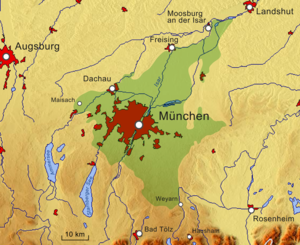
The surface gravel and sand deposits have been exploited for use in construction for a long time. There still remain several sand and gravel plants as in
Grasbrunn and at
412:
652:
611:
430:
172:
pleistocene glaciers, that almost reached to the area of modern Munich, discharged not only water but also large amounts of soil and rock into the
234:
river is the largest body of water on the Munich gravel plain. It roughly equally bisects the plain from southwest to northeast. Coming from the
216:
river flowed through the eastern section of what is now the Munich gravel plain before it was deflected to the east towards the Inn river by a
307:
627:
586:
516:"Auswirkungen veränderter agrarpolitischer Rahmenbedingungen auf ausgewählte Betriebe – dargestellt am Beispiel einer Kleinregion"
463:
149:
100:
The plain covers a triangular area of around 1500 km (= 579.15 mi). The three corners corresponded with the town of
746:
761:
246:
and the Gröbenbach and its tributaries, which all, due to exudation of groundwater, rise on the Munich gravel plain.
756:
751:
366:
346:
109:
322:(Böhmerweiher Lake) was created between 1993 and 1999 by sand and gravel mining for the construction of the
193:. Layers of clay in between represent the interim humus collections of the respective interglacial periods.
141:
deposits of 100 m (330 ft) are the deepest in the south of Munich and decrease towards the north.
693:
670:
725:
235:
169:
113:
259:
78:
540:
217:
190:
646:
605:
406:
315:
196:
All these ice age gravel deposits lie on top of the low hydraulic conductive sediments of the
182:
19:
489:
323:
48:
290:
729:
392:"The geology of Munich (Germany) and its significance for ground modelling in urban areas"
186:
173:
70:
32:
631:
590:
242:
river flows through the west of the Munich gravel plain. Further natural waters are the
717:
353:, which provided gravel for the construction of the Autobahn A 8 during the 1930s, the
330:
243:
165:
51:
279:
740:
391:
197:
66:
55:
44:
40:
515:
177:
161:
96:
building pit (Munich-Aubing); very thin soil layer on top of thick gravel deposit
133:
ground in several stages and caused the typical terrace levels within the city.
224:
130:
126:
92:
563:
268:
264:
154:
723:
Homepage of the
Miocene Northern Alpine Molasse Zone scientists association
361:, from which gravel was used from 1995 to 2000 for the construction of the
490:"Lumineszenzdatierung glazifluvialer Sedimente im nördlichen Alpenvorland"
189:, which in turn is covered by the youngest layer, the rock scree from the
299:
213:
105:
74:
671:"Badeseen in und rund um München: der Feringasee im Nordosten Münchens"
284:
239:
220:
117:
63:
357:, from which gravel was extracted for a railway line in 1938, and the
138:
121:
101:
81:
278:
148:
129:
features. However, the waters of the Isar river have cut into the
349:
to the west of Munich. The
Langwieder lake district includes the
263:
named after the owners of these precious water sources, such as
231:
59:
625:
Hochwassernachrichtendienst des Bayer. Landesamtes für Umwelt
584:
Hochwassernachrichtendienst des Bayer. Landesamtes für Umwelt
314:(Feringa Lake) gravel was used for the construction of the
722:
54:. Characterized by its very wide extension, it comprises
718:Grundwassermodell Östliche Münchner Schotterebene
329:Former gravel pits are also all the lakes of the
164:record the formation process extended over three
227:is a sector of the former course of the river.
431:"Landschaftsentwicklung in der Region München"
62:river. These most recent deposits overlie the
306:(Heimstetten Lake), gravel was mined for the
16:Pleistocene Outwash plain in Bavaria, Germany
8:
411:: CS1 maint: multiple names: authors list (
390:Markus Bauer, Kurosch Thuro, Peter Neumann.
73:, which in contrast comprises fine-grained
23:Relief map with Munich Gravel Plain (green)
514:Swantje Mignon Schlederer (May 12, 2006).
271:(Gramasprunnin after a Gramas or Graman).
333:(Three Lake district), that include the
289:
91:
18:
665:
663:
377:
651:: CS1 maint: archived copy as title (
644:
610:: CS1 maint: archived copy as title (
603:
469:. Deutsche Bodenkundliche Gesellschaft
404:
457:
455:
453:
451:
424:
422:
385:
383:
381:
267:(once Puzzoprunnin after a Puzzo) or
7:
543:. Geologie Digital. October 2, 2018
212:During the pleistocene the ancient
58:terraces and the floodplain of the
176:. When the glaciers melted during
14:
521:. Technische Universität München
185:, above it lies gravel from the
541:"Das Süddeutsche Molassebecken"
462:Karl Auerswald, Christian Ahl.
692:Stefan Herbke (May 17, 2010).
564:"Grub-Harthausener Trockental"
436:. Leibniz Universität Hannover
1:
464:"Unsere Böden – Unser Leben"
302:. At the site of the modern
160:According to an unambiguous
345:and the three lakes of the
778:
696:. Süddeutsche Zeitung GmbH
204:are impermeable to water.
153:Munich gravel plain near
47:, Germany, formed during
347:Langwieder lake district
694:"Langwieder Seenplatte"
318:from 1974 to 1976, the
294:Langwieder Lake in 2012
295:
287:
223:. The Grub-Harthausen
157:
97:
37:Münchner Schotterebene
36:
24:
293:
282:
275:Economic significance
236:district of Starnberg
152:
116:in the northeast and
95:
22:
747:Landforms of Bavaria
114:Moosburg an der Isar
762:Geography of Munich
367:metropolitan Munich
363:Eschenrieder Spange
29:Munich gravel plain
728:2009-04-05 at the
562:Jürgen Wienböker.
296:
288:
158:
112:in the southeast,
98:
25:
757:Plains of Germany
752:Glacial landforms
429:Hansjörg Küster.
343:Feldmochinger See
304:Heimstettener See
183:Mindel glaciation
769:
706:
705:
703:
701:
689:
683:
682:
680:
678:
667:
658:
656:
650:
642:
640:
639:
630:. Archived from
623:
617:
615:
609:
601:
599:
598:
589:. Archived from
582:
576:
575:
573:
571:
559:
553:
552:
550:
548:
537:
531:
530:
528:
526:
520:
511:
505:
504:
502:
500:
494:
485:
479:
478:
476:
474:
468:
459:
446:
445:
443:
441:
435:
426:
417:
416:
410:
402:
400:
398:
387:
310:until 1937. The
283:Gravel pit near
49:Late Pleistocene
777:
776:
772:
771:
770:
768:
767:
766:
737:
736:
730:Wayback Machine
714:
709:
699:
697:
691:
690:
686:
676:
674:
673:. Ganz Muenchen
669:
668:
661:
643:
637:
635:
628:"Archived copy"
626:
624:
620:
602:
596:
594:
587:"Archived copy"
585:
583:
579:
569:
567:
561:
560:
556:
546:
544:
539:
538:
534:
524:
522:
518:
513:
512:
508:
498:
496:
492:
488:Nicole Klasen.
487:
486:
482:
472:
470:
466:
461:
460:
449:
439:
437:
433:
428:
427:
420:
403:
396:
394:
389:
388:
379:
375:
335:Lerchenauer See
277:
252:
218:Würm glaciation
210:
191:Würm glaciation
187:Riss glaciation
174:Alpine Foreland
166:glacial periods
147:
90:
71:Alpine Foreland
52:glacial periods
17:
12:
11:
5:
775:
773:
765:
764:
759:
754:
749:
739:
738:
733:
732:
720:
713:
712:External links
710:
708:
707:
684:
659:
618:
577:
554:
532:
506:
480:
447:
418:
376:
374:
371:
351:Langwieder See
331:Dreiseenplatte
276:
273:
251:
248:
244:Hachinger Bach
209:
206:
170:Central Alpine
168:. The massive
146:
143:
89:
86:
15:
13:
10:
9:
6:
4:
3:
2:
774:
763:
760:
758:
755:
753:
750:
748:
745:
744:
742:
735:
731:
727:
724:
721:
719:
716:
715:
711:
695:
688:
685:
672:
666:
664:
660:
654:
648:
634:on 2006-08-22
633:
629:
622:
619:
613:
607:
593:on 2006-08-22
592:
588:
581:
578:
565:
558:
555:
542:
536:
533:
517:
510:
507:
491:
484:
481:
465:
458:
456:
454:
452:
448:
432:
425:
423:
419:
414:
408:
393:
386:
384:
382:
378:
372:
370:
368:
364:
360:
356:
352:
348:
344:
340:
339:Fasanerie See
336:
332:
327:
325:
321:
317:
316:Autobahn A 99
313:
309:
305:
301:
292:
286:
281:
274:
272:
270:
266:
261:
256:
249:
247:
245:
241:
237:
233:
228:
226:
222:
219:
215:
207:
205:
203:
199:
198:Molasse basin
194:
192:
188:
184:
179:
175:
171:
167:
163:
162:stratigraphic
156:
151:
144:
142:
140:
134:
132:
128:
123:
120:in the west.
119:
115:
111:
107:
103:
94:
87:
85:
83:
80:
76:
72:
68:
67:Molasse basin
65:
61:
57:
53:
50:
46:
45:Upper Bavaria
42:
41:outwash plain
38:
34:
30:
21:
734:
698:. Retrieved
687:
675:. Retrieved
636:. Retrieved
632:the original
621:
595:. Retrieved
591:the original
580:
568:. Retrieved
557:
545:. Retrieved
535:
523:. Retrieved
509:
497:. Retrieved
483:
471:. Retrieved
438:. Retrieved
395:. Retrieved
362:
358:
354:
350:
342:
338:
334:
328:
324:Autobahn A 8
320:Böhmerweiher
319:
311:
303:
297:
257:
253:
229:
211:
201:
195:
178:interglacial
159:
135:
99:
28:
26:
700:January 16,
677:January 16,
570:January 15,
547:January 15,
525:January 16,
499:January 16,
473:January 15,
440:January 15,
397:January 13,
250:Groundwater
127:topographic
110:Holzkirchen
741:Categories
638:2020-01-15
597:2020-01-15
495:. Uni Köln
373:References
312:Feringasee
308:Reichsbahn
230:Today the
225:dry valley
131:Quaternary
104:, between
79:lacustrine
75:fluviatile
355:Birkensee
269:Grasbrunn
265:Putzbrunn
260:Thickness
155:Ottobrunn
145:Formation
726:Archived
647:cite web
606:cite web
407:cite web
300:Aschheim
214:Mangfall
106:Miesbach
88:Location
39:) is an
285:Planegg
221:moraine
118:Maisach
69:of the
64:Neogene
566:. GRUB
359:Lußsee
238:, the
208:Waters
139:gravel
122:Munich
102:Weyarn
82:facies
56:sandur
33:German
519:(PDF)
493:(PDF)
467:(PDF)
434:(PDF)
202:Flinz
702:2020
679:2020
653:link
612:link
572:2020
549:2020
527:2020
501:2020
475:2020
442:2020
413:link
399:2020
341:and
258:The
240:Würm
232:Isar
108:and
77:and
60:Isar
27:The
43:in
743::
662:^
649:}}
645:{{
608:}}
604:{{
450:^
421:^
409:}}
405:{{
380:^
369:.
337:,
326:.
84:.
35::
704:.
681:.
657:.
655:)
641:.
616:.
614:)
600:.
574:.
551:.
529:.
503:.
477:.
444:.
415:)
401:.
31:(
Text is available under the Creative Commons Attribution-ShareAlike License. Additional terms may apply.