158:
17:
125:
infinite plain stretches south to the horizon, relieved here and there by a solitary farmstead nestled down in the deep foliage. Right in front of you, and only four miles and a half away, in an air line, the great steeple of
Alexandria, banner-crowned, stands up against the clear sky. The town itself is obscured by an intervening strip of woodland; but the works on Seminary Hill, which command the approach, can be seen with the naked eye. To the left of these fortifications, the dome of the Capitol lifts its ponderous head from the white shoulders of the city, which slope away on either side...
135:
184:, shot and killed as many Union army soldiers as they could. During one particularly intense firefight very close to the Munson home, Daniel Munson mounted his horse and attempted to flee toward Union army lines. As he exited his gate onto the Leesburg Turnpike, Confederate sharpshooters shot his horse out from under him. He got up and ran across the fields towards Bailey's Crossroads and escaped capture, eventually making it to the protection of Union lines.
497:
398:
191:, which they fortified. The Union Army, to its extreme embarrassment, discovered the fearsome-looking cannon to be "Quaker guns" – logs painted black. The army was the subject of ridicule throughout the North, where confounded citizens pondered how their army was kept at bay for two months with nothing more than what Mother Nature grew in her own foundry!
81:, where Leesburg Pike, U.S. Route 50, Sleepy Hollow Road, and Wilson Boulevard intersect. Until recent decades the area of heights where the roads intersect was called Perkins' Hill and was considered a geographically distinct hill by local residents. Geographers, however, appear to consider the two as one.
109:
built a fine home on the south side of the
Leesburg Pike, at the crook where it curves around the summit of Munson's Hill. The home was demolished 100 years later, in 1962, to make way for a large apartment building, Munson Hill Apartments (now Towers), which still stands on the site at 6129 Leesburg Pike.
232:
The Munson's Hill
Nurseries recovered after the Civil War and supplied much of Northern Virginia with its domesticated greenery. In Falls Church Broad Street and Washington Street were lined with silver maples planted by Daniel Munson in 1889. Those lining West Broad Street were cut in 1948–49, and
172:
A stalemate then ensued, as
Washington and its residents grew increasingly concerned that the Confederacy would launch an attack from Falls Church and its hills via the river bridges. Observers at the U.S. Capitol, using "looking glasses" (telescopes), could see fearsome-looking Confederate cannon
115:
Munson's Hill overlooks the broad, flat plain that is Bailey's
Crossroads. During the Civil War Confederate Army officers and Southern journalists visited frequently and never failed to remark upon the view, which included much of Washington, D.C., and Northern Virginia. One war correspondent of
108:
Munson's Hill takes its name from Daniel O. Munson, who moved to a 180-acre (0.73 km) farm on the hill in 1851 and opened an extensive nursery, later called Munson Hill
Nurseries, which operated into the mid-1900s. Munson was joined on his farm by his father, Timothy Bishop Munson, and they
124:
Standing on the crest of the hill, the panorama unrolled before you, is one of exquisite beauty. The river sweeps around the base of the hills beyond, hidden from view, but easily traced by the blue line of mist which marks its course. Beyond the unseen boundary of our contending countries an
202:
Life during this time was hard for the
Munsons, particularly the elderly Timothy B. Munson, who as a native New Yorker felt it necessary to seek refuge in Washington. After the Southern army withdrew from the area he suffered numerous deprivations while under the military rule of the Union
157:
217:
of Munson's Hill were published in the
American and British press during the early months of the Civil War. Several depict Daniel Munson's three-story barn, and one depicts his home. These have been reprinted in full in a local history of the Civil War entitled
92:
occurs in a natural depression. The lower portion of
Washington, D.C., and its Monumental Core thus are located in a naturally occurring "bowl" circled by hills and bluffs on every side. Munson's Hill is a part of this encircling chain, along with
194:
Songs were written by
Northern lyricists lampooning their army. "The Bold Engineer", "Munson's Hill!", and "The Battle of the Stove-Pipes" all poke caustic fun at Northern generals. One song called Munson's Hill a
243:, consisting of many large stores and shopping centers lining either side of Leesburg Pike. The hill's slopes and former summit are occupied by single-family housing. It is today an important commercial area.
430:
112:
In 1955 the summit of Munson's Hill was bulldozed and flattened to create more land on which to build single-family homes. The hill as it appears today is somewhat shorter than before.
423:
236:
The legacy of the Munson trees—which formed a beautiful leafy bower—continues to be something Falls Church seeks to emulate today, through successful street-tree planting programs.
146:, when it made international news headlines repeatedly. After the war opened in South Carolina, events quickly moved to Northern Virginia. A calamitous loss suffered at the
187:
This all changed during the night of September 28, 1861. The Confederate Army silently withdrew from Falls Church and Munson's, Mason's and Upton's hills, and retreated to
811:
416:
750:
821:
16:
166:
282:
220:
760:
588:
471:
466:
204:
593:
583:
150:
by the Union Army in July 1861 caused it to withdraw almost completely from Northern Virginia. Confederate Army troops quickly occupied Munson's,
42:
207:, from Munson's home state. In a letter to a Washington newspaper Munson cataloged all the deprivations and offenses and closed with the plea,
154:
and Mason's hills, from which they had commanding views of the plain of Bailey's Crossroads and all the way into the federal capital.
239:
Munson's Hill was fully developed in the 1950s and early 1960s. Much of it is covered by the commercial and shopping area called
181:
568:
725:
680:
685:
451:
402:
816:
486:
577:
481:
745:
740:
735:
613:
598:
476:
147:
28:
608:
537:
785:
558:
174:
134:
180:
The area became a deathtrap during this time as Confederate sharpshooters, with their commanding view of
553:
516:
461:
188:
710:
695:
563:
408:
603:
456:
664:
209:"My God! How long must these things continue? We may well exclaim, Save us from our friends!!!"
143:
755:
511:
20:
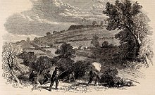
Skirmishing between the pickets of the two armies near Munson’s Hill, the hill in the distance
715:
649:
634:
496:
161:
Munson's Hill, with the Earthwork thrown up by the Confederates in front of the Union Lines
790:
700:
690:
659:
573:
532:
203:
Army—-and, ironically, the worst were meted out by the poorly disciplined soldiers of the
89:
780:
770:
765:
151:
102:
98:
94:
74:
805:
654:
644:
240:
85:
78:
730:
639:
629:
233:
those along East Broad Street met their doom in 1958, all due to street widening.
214:
177:, just 1.4 miles (2.3 km) away, hosted the local Confederate headquarters.
720:
57:
44:
705:
120:
newspaper visited in September 1861 and offered the following description:
397:
173:
mounted in emplacements all across Munson's Hill. The village of
156:
133:
15:
283:
A Virginia Village Goes to War--Falls Church During the Civil War
221:
A Virginia Village Goes to War--Falls Church During the Civil War
412:
31:. Its summit rises to 367 feet (112 m) above sea level.
77:(410 ft) on its north. It is located at an area called
165:
More to the point, Washingtonians could also see a massive
350:
Each of the songs is reprinted in full by Gernand in
673:
622:
546:
525:
504:
444:
138:
Confederate positions on the hill in September 1861
439:Fairfax County, Virginia in the American Civil War
169:fluttering in the breeze from high atop the hill.
286:. Virginia Beach: The Donning Company. P. 233.
258:Falls Church quad, U.S. Geological Survey map.
751:St. Mary's Church (Fairfax Station, Virginia)
424:
8:
27:is a geographic eminence located in eastern
298:, September 10, 1861 as quoted in Gernand,
431:
417:
409:
761:William Gunnell House (Fairfax, Virginia)
589:45th New York Volunteer Infantry Regiment
472:Battle of Fairfax Court House (June 1863)
467:Battle of Fairfax Court House (June 1861)
812:Fairfax County in the American Civil War
594:16th Regiment New York Volunteer Cavalry
584:3rd Michigan Volunteer Infantry Regiment
251:
822:Landforms of Fairfax County, Virginia
271:. Privately published, 1964, p. 381.
7:
569:43rd Battalion of Virginia Cavalry
382:Falls Church By Fence and Fireside
269:Falls Church by Fence and Fireside
14:
495:
396:
142:The hill was famous during the
97:to its immediate southeast and
726:Oak Hill (Annandale, Virginia)
681:Clarens (Alexandria, Virginia)
369:A Virginia Village Goes to War
352:A Virginia Village Goes to War
339:A Virginia Village Goes to War
326:A Virginia Village Goes to War
313:A Virginia Village Goes to War
300:A Virginia Village Goes to War
1:
686:Centreville Military Railroad
39:Munson's Hill is located at
838:
487:Battle of Vienna, Virginia
452:Battle of Blackburn's Ford
363:Published in Washington's
578:Jeff Davis Cavalry Legion
493:
482:Second Battle of Bull Run
267:Melvin L. Steadman, Jr.
746:Ravensworth (plantation)
741:Ox Hill Battlefield Park
736:Ossian Hall (plantation)
614:Union Army Balloon Corps
599:First New Jersey Brigade
477:First Battle of Bull Run
148:First Battle of Manassas
105:hills to its northwest.
73:The hill is adjacent to
29:Fairfax County, Virginia
609:XXII Corps (Union Army)
559:17th Virginia Infantry
367:and cited in Gernand,
205:37th New York Infantry
162:
139:
127:
21:
554:8th Virginia Infantry
462:Battle of Dranesville
280:Bradley E. Gernand.
160:
137:
122:
58:38.85983°N 77.14554°W
19:
711:Huntley (plantation)
696:Fort Lyon (Virginia)
564:1st Virginia Cavalry
533:Burke's Station Raid
405:at Wikimedia Commons
84:The junction of the
786:Bailey's Crossroads
604:2nd Vermont Brigade
457:Battle of Chantilly
182:Bailey's Crossroads
63:38.85983; -77.14554
54: /
665:Edwin H. Stoughton
296:Charleston Mercury
197:"mountain of sand"
163:
144:American Civil War
140:
118:Charleston Mercury
22:
817:Hills of Virginia
799:
798:
512:Bog Wallow Ambush
401:Media related to
341:, pp. 75–76, 100.
35:Location and name
829:
650:John Quincy Marr
635:Michael Corcoran
499:
433:
426:
419:
410:
400:
385:
378:
372:
361:
355:
348:
342:
335:
329:
322:
316:
309:
303:
293:
287:
278:
272:
265:
259:
256:
167:Confederate flag
69:
68:
66:
65:
64:
59:
55:
52:
51:
50:
47:
837:
836:
832:
831:
830:
828:
827:
826:
802:
801:
800:
795:
791:Wolf Run Shoals
756:Taylor's Tavern
701:Fort Marcy Park
691:Colvin Run Mill
669:
660:Laura Ratcliffe
618:
574:Georgia Hussars
542:
521:
500:
491:
440:
437:
393:
388:
379:
375:
362:
358:
349:
345:
336:
332:
323:
319:
310:
306:
294:
290:
279:
275:
266:
262:
257:
253:
249:
230:
132:
90:Anacostia River
62:
60:
56:
53:
48:
45:
43:
41:
40:
37:
12:
11:
5:
835:
833:
825:
824:
819:
814:
804:
803:
797:
796:
794:
793:
788:
783:
778:
773:
768:
763:
758:
753:
748:
743:
738:
733:
728:
723:
718:
713:
708:
703:
698:
693:
688:
683:
677:
675:
671:
670:
668:
667:
662:
657:
652:
647:
642:
637:
632:
626:
624:
620:
619:
617:
616:
611:
606:
601:
596:
591:
586:
581:
571:
566:
561:
556:
550:
548:
544:
543:
541:
540:
535:
529:
527:
523:
522:
520:
519:
514:
508:
506:
502:
501:
494:
492:
490:
489:
484:
479:
474:
469:
464:
459:
454:
448:
446:
442:
441:
438:
436:
435:
428:
421:
413:
407:
406:
392:
391:External links
389:
387:
386:
373:
356:
343:
330:
317:
304:
288:
273:
260:
250:
248:
245:
229:
226:
131:
128:
36:
33:
13:
10:
9:
6:
4:
3:
2:
834:
823:
820:
818:
815:
813:
810:
809:
807:
792:
789:
787:
784:
782:
779:
777:
776:Munson's Hill
774:
772:
769:
767:
764:
762:
759:
757:
754:
752:
749:
747:
744:
742:
739:
737:
734:
732:
729:
727:
724:
722:
719:
717:
716:Fort O'Rourke
714:
712:
709:
707:
704:
702:
699:
697:
694:
692:
689:
687:
684:
682:
679:
678:
676:
672:
666:
663:
661:
658:
656:
655:John S. Mosby
653:
651:
648:
646:
645:Thaddeus Lowe
643:
641:
638:
636:
633:
631:
628:
627:
625:
621:
615:
612:
610:
607:
605:
602:
600:
597:
595:
592:
590:
587:
585:
582:
579:
575:
572:
570:
567:
565:
562:
560:
557:
555:
552:
551:
549:
545:
539:
538:Mosby's Raids
536:
534:
531:
530:
528:
524:
518:
515:
513:
510:
509:
507:
503:
498:
488:
485:
483:
480:
478:
475:
473:
470:
468:
465:
463:
460:
458:
455:
453:
450:
449:
447:
443:
434:
429:
427:
422:
420:
415:
414:
411:
404:
403:Munson's Hill
399:
395:
394:
390:
383:
377:
374:
370:
366:
360:
357:
353:
347:
344:
340:
334:
331:
327:
321:
318:
314:
308:
305:
301:
297:
292:
289:
285:
284:
277:
274:
270:
264:
261:
255:
252:
246:
244:
242:
241:Seven Corners
237:
234:
227:
225:
223:
222:
216:
211:
210:
206:
200:
198:
192:
190:
185:
183:
178:
176:
170:
168:
159:
155:
153:
149:
145:
136:
129:
126:
121:
119:
113:
110:
106:
104:
100:
96:
91:
87:
86:Potomac River
82:
80:
79:Seven Corners
76:
71:
67:
34:
32:
30:
26:
25:Munson's Hill
18:
781:Upton's Hill
775:
771:Minor's Hill
766:Mason's Hill
731:Okeley Manor
640:Antonia Ford
630:Clara Barton
580:, Company F)
381:
376:
371:, pp. 71–72.
368:
365:Evening Star
364:
359:
354:, pp. 75–76.
351:
346:
338:
333:
325:
320:
312:
307:
299:
295:
291:
281:
276:
268:
263:
254:
238:
235:
231:
219:
212:
208:
201:
196:
193:
186:
179:
175:Falls Church
171:
164:
141:
123:
117:
114:
111:
107:
95:Mason's Hill
83:
75:Upton's Hill
72:
38:
24:
23:
517:Lewinsville
215:lithographs
189:Centreville
61: /
806:Categories
721:Merrybrook
505:Skirmishes
380:Steadman,
247:References
228:Modern era
49:77°08′44″W
46:38°51′35″N
706:Hope Park
384:, p. 196.
337:Gernand,
324:Gernand,
311:Gernand,
213:Numerous
88:with the
328:, p. 73.
315:, p. 77.
302:, p. 81.
576:(later
445:Battles
152:Upton's
130:History
103:Minor's
99:Upton's
623:People
674:Sites
547:Units
526:Raids
116:the
101:and
808::
224:.
199:.
70:.
432:e
425:t
418:v
Text is available under the Creative Commons Attribution-ShareAlike License. Additional terms may apply.