29:
221:
228:
385:
500:
302:
The
Mzingwane River is an ephemeral river with flow generally restricted to the months when rain takes place (November to March), with most flow recorded between December and February, except where it has been modified by dam operations. The river contributes 9.3% of the mean annual runoff of the
608:
Love, D., Uhlenbrook, S., Nyabeze, W., Owen, R.J.S., Twomlow, S., Savenije, H. , Woltering, L. and van der Zaag, P. 2005. Modelling of hydrological change for IWRM planning: case study of the
Mzingwane River, Limpopo Basin, Zimbabwe. In: Abstract Volume, 6th WaterNet/WARFSA/GWP-SA Symposium,
337:
in the river channel and below the alluvial plains. Estimated water resources potential of these aquifers ranges between 175,000 and 5,430,000 cubic metres (6,200,000 and 191,800,000 cu ft) in the channels and between 80,000 and 6,920,000 cubic metres (2,800,000 and
620:
Moyce, W., Mangeya, P., Owen, R. and Love, D. 2006. Alluvial aquifers in the
Mzingwane Catchment: their distribution, properties, current usage and potential expansion. Physics and Chemistry of the Earth, 31, 988-994.
338:
244,400,000 cu ft) in the plains. Currently, some of these aquifers are being used to provide water for domestic use, livestock watering and dip tanks, commercial irrigation and market gardening.
951:
691:
956:
241:
220:
122:
136:
684:
941:
677:
633:
712:
700:
946:
371:
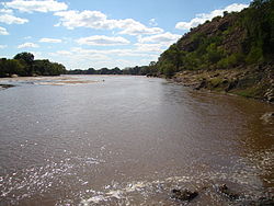
town is located about 6 km ESE of the confluence of the Bubye River and the
Limpopo on the border with
28:
596:
Limpopo River: flow balance anomalies, surprises and implications for integrated water resources management
845:
840:
540:, built in 1995, with a full supply capacity of 136 MCM. It is located near the confluence with the
870:
527:
271:
556:
915:
825:
810:
785:
780:
750:
740:
567:
563:
327:
323:
319:
311:
275:
34:
885:
850:
725:
552:
473:
466:
443:
362:
935:
900:
875:
855:
815:
800:
795:
790:
770:
760:
755:
571:
541:
523:
417:
263:
118:
895:
890:
880:
860:
775:
765:
745:
447:
384:
372:
307:
287:
910:
905:
865:
835:
820:
735:
730:
720:
530:). It is located near the source of the river and supplies water to the city of
315:
291:
103:
622:
598:. Proceedings of the 8th South African National Hydrology Symposium. Pretoria.
545:
537:
508:
504:
499:
487:
480:
454:
439:
405:
389:
368:
346:
The settlements below are ordered from the beginning of the river to its end:
283:
38:
151:
138:
610:
424:
413:
409:
350:
333:
The lower
Mzingwane River is a sand filled channel, with extensive alluvial
303:
Limpopo Basin, making it the third largest tributary to the
Limpopo basin.
704:
637:
531:
435:
428:
401:
279:
267:
92:
88:
58:
42:
920:
805:
334:
669:
356:
498:
383:
516:
673:
562:
A project is underway to construct a pipeline from the upper
526:, built in 1962, with a full supply capacity of 42 MCM (
396:
There are four main bridges over the
Mzingwane River:
306:
Major tributaries of the
Mzingwane River include the
711:
519:, there are two major dams on the Mzingwane River:
197:
189:
177:
167:
128:
112:
102:
81:
73:
64:
54:
49:
21:
388:Bertie Knott Bridge on the Mzingwane River near
662:. Bulawayo: Zimbabwe National Water Authority.
559:, but development is not currently scheduled.
685:
658:Chibi, T.; Kandori, C.; Makone, B.F. (2005).
551:Additional dam sites have been identified at
461:There are also a number of fords, including:
8:
457:to Shashe Irrigation Scheme, near the mouth.
692:
678:
670:
952:Geography of Matabeleland South Province
609:Ezulwini, Swaziland, November 2005, p31.
589:
587:
583:
245:Location of the Mzingwane River's mouth
594:Görgens, A.H.M.; Boroto, R.A. (1997).
469:on Silalabuhwa and Mosholomoshe roads.
453:Bertie Knott Bridge, on the road from
282:and flows into the Limpopo River near
262:is a major left-bank tributary of the
203:22.30 m/s (788 cu ft/s)
181:15,695 km (6,060 sq mi)
18:
544:and supplies water for irrigation to
7:
14:
515:In addition to a number of small
290:and upstream of the mouth of the
286:, downstream of the mouth of the
227:
957:Tributaries of the Limpopo River
660:Mzingwane Catchment Outline Plan
446:, downstream of confluence with
226:
219:
27:
472:Doddieburn ford, downstream of
33:Mzingwane River above Fulton's
450:. There is also a rail bridge.
420:. There is also a rail bridge.
130: • coordinates
1:
375:. It was established in 1929.
65:Physical characteristics
169: • elevation
123:South Africa–Zimbabwe border
114: • location
83: • location
973:
199: • average
173:452 m (1,483 ft)
566:(not to be confused with
322:(not to be confused with
211:
207:
185:
98:
69:
26:
512:
465:Two fords upstream of
393:
502:
486:Fulton's Drift, near
387:
380:Bridges and crossings
152:22.18694°S 29.92556°E
528:million cubic metres
254:, formerly known as
242:class=notpageimage|
157:-22.18694; 29.92556
148: /
942:Rivers of Zimbabwe
513:
394:
929:
928:
479:Gems Drift, near
260:Umzingwani River,
215:
214:
37:(causeway), near
16:River in Zimbabwe
964:
846:Ngezi (Midlands)
841:Ngezi (Masvingo)
694:
687:
680:
671:
664:
663:
655:
649:
648:
646:
645:
636:. Archived from
630:
624:
618:
612:
606:
600:
599:
591:
416:, downstream of
270:. It rises near
256:Umzingwane River
230:
229:
223:
200:
163:
162:
160:
159:
158:
153:
149:
146:
145:
144:
141:
84:
31:
19:
972:
971:
967:
966:
965:
963:
962:
961:
947:Mzingwane River
932:
931:
930:
925:
707:
698:
668:
667:
657:
656:
652:
643:
641:
632:
631:
627:
619:
615:
607:
603:
593:
592:
585:
580:
568:Umchabezi River
564:Mtshabezi River
497:
434:Bridge on main
423:Bridge on main
400:Bridge on main
382:
344:
300:
276:Matobo District
252:Mzingwane River
248:
247:
246:
244:
238:
237:
236:
235:
231:
198:
170:
156:
154:
150:
147:
142:
139:
137:
135:
134:
131:
115:
82:
45:
22:Mzingwane River
17:
12:
11:
5:
970:
968:
960:
959:
954:
949:
944:
934:
933:
927:
926:
924:
923:
918:
913:
908:
903:
898:
893:
888:
883:
878:
873:
868:
863:
858:
853:
848:
843:
838:
833:
828:
823:
818:
813:
808:
803:
798:
793:
788:
783:
778:
773:
768:
763:
758:
753:
748:
743:
738:
733:
728:
723:
717:
715:
709:
708:
699:
697:
696:
689:
682:
674:
666:
665:
650:
625:
613:
601:
582:
581:
579:
576:
549:
548:
535:
496:
493:
492:
491:
484:
477:
474:West Nicholson
470:
467:West Nicholson
459:
458:
451:
444:West Nicholson
432:
421:
408:road, between
381:
378:
377:
376:
366:
363:West Nicholson
360:
354:
343:
340:
299:
296:
240:
239:
233:
232:
225:
224:
218:
217:
216:
213:
212:
209:
208:
205:
204:
201:
195:
194:
191:
187:
186:
183:
182:
179:
175:
174:
171:
168:
165:
164:
132:
129:
126:
125:
116:
113:
110:
109:
106:
100:
99:
96:
95:
85:
79:
78:
75:
71:
70:
67:
66:
62:
61:
56:
52:
51:
47:
46:
32:
24:
23:
15:
13:
10:
9:
6:
4:
3:
2:
969:
958:
955:
953:
950:
948:
945:
943:
940:
939:
937:
922:
919:
917:
914:
912:
909:
907:
904:
902:
899:
897:
894:
892:
889:
887:
884:
882:
879:
877:
874:
872:
869:
867:
864:
862:
859:
857:
854:
852:
849:
847:
844:
842:
839:
837:
834:
832:
829:
827:
824:
822:
819:
817:
814:
812:
809:
807:
804:
802:
799:
797:
794:
792:
789:
787:
784:
782:
779:
777:
774:
772:
769:
767:
764:
762:
759:
757:
754:
752:
749:
747:
744:
742:
739:
737:
734:
732:
729:
727:
724:
722:
719:
718:
716:
714:
710:
706:
702:
695:
690:
688:
683:
681:
676:
675:
672:
661:
654:
651:
640:on 2016-11-06
639:
635:
629:
626:
623:
617:
614:
611:
605:
602:
597:
590:
588:
584:
577:
575:
573:
572:Mzingwane Dam
569:
565:
560:
558:
554:
547:
543:
542:Limpopo River
539:
536:
533:
529:
525:
524:Mzingwane Dam
522:
521:
520:
518:
510:
506:
501:
494:
489:
485:
482:
478:
475:
471:
468:
464:
463:
462:
456:
452:
449:
445:
441:
437:
433:
430:
426:
422:
419:
418:Mzingwane Dam
415:
411:
407:
403:
399:
398:
397:
391:
386:
379:
374:
370:
367:
364:
361:
358:
355:
352:
349:
348:
347:
341:
339:
336:
331:
329:
325:
321:
317:
313:
309:
304:
297:
295:
293:
289:
285:
281:
277:
273:
269:
265:
264:Limpopo River
261:
257:
253:
243:
222:
210:
206:
202:
196:
192:
188:
184:
180:
176:
172:
166:
161:
133:
127:
124:
120:
119:Limpopo River
117:
111:
107:
105:
101:
97:
94:
90:
86:
80:
76:
72:
68:
63:
60:
57:
53:
48:
44:
40:
36:
30:
25:
20:
830:
659:
653:
642:. Retrieved
638:the original
634:"Beitbridge"
628:
616:
604:
595:
561:
557:Oakley Block
550:
514:
503:Spillway of
460:
448:Insiza River
395:
373:South Africa
345:
332:
305:
301:
288:Shashe River
259:
255:
251:
249:
495:Development
342:Settlements
292:Bubye River
278:, south of
155: /
936:Categories
826:Mtetengwe
644:2012-03-18
578:References
553:Glassblock
546:Beitbridge
538:Zhovhe Dam
509:Beitbridge
505:Zhovhe Dam
488:Beitbridge
481:Beitbridge
455:Beitbridge
440:Beitbridge
406:Beitbridge
390:Beitbridge
369:Beitbridge
284:Beitbridge
272:Fort Usher
178:Basin size
143:29°55′32″E
140:22°11′13″S
39:Beitbridge
916:Umchabezi
831:Mzingwane
811:Mutirikwe
786:Mtshelele
781:Mtshabezi
751:Inyankuni
741:Inkankezi
425:Mbalabala
414:Mbalabala
410:Esigodini
351:Mbalabala
328:Mtetengwe
324:Mtshabezi
320:Umchabezi
312:Inyankuni
298:Hydrology
234:Mzingwane
190:Discharge
87:South of
886:Shangani
851:Ngondoma
726:Chiredzi
705:Zimbabwe
532:Bulawayo
442:road at
436:Bulawayo
429:Masvingo
402:Bulawayo
335:aquifers
330:Rivers.
280:Bulawayo
268:Zimbabwe
93:Zimbabwe
89:Bulawayo
59:Zimbabwe
50:Location
43:Zimbabwe
921:Zambezi
901:Tokwane
876:Sebakwe
856:Panhane
816:Mwenezi
806:Mushawe
801:Mupfure
796:Munyati
791:Mucheke
771:Manyame
761:Limpopo
756:Kwe Kwe
507:, near
365:village
353:village
55:Country
896:Siwaze
891:Shashe
881:Sengwa
861:Pungwe
776:Mazowe
766:Luenha
746:Insiza
713:Rivers
701:Rivers
357:Gwanda
326:) and
308:Insiza
193:
108:
77:
74:Source
911:Thuli
906:Tokwe
866:Runde
836:Ncema
821:Mwewe
736:Honde
731:Gwayi
721:Bubye
570:) to
517:weirs
431:road.
316:Ncema
104:Mouth
35:Drift
871:Save
555:and
412:and
359:town
250:The
703:of
266:in
258:or
938::
586:^
574:.
438:-
427:-
404:-
318:,
314:,
310:,
294:.
274:,
121:,
91:,
41:,
693:e
686:t
679:v
647:.
534:.
511:.
490:.
483:.
476:.
392:.
Text is available under the Creative Commons Attribution-ShareAlike License. Additional terms may apply.