775:
763:
467:, the population of MacGregor was 5,576, 51.6% female and 48.4% male. The median age of the MacGregor population was 32 years of age, 5 years below the Australian median. Of all people living in MacGregor, 41.9% were born in Australia, compared to the national average of 69.8%; the next most common countries of birth were China 15%, Taiwan 6.3%, India 4.6%, New Zealand 3.3% and Vietnam at 2.3%. 44.4% of people spoke only English at home; the next most popular languages were 20.2% Mandarin, 7.2% Cantonese, 2.7% Vietnamese, 2.3% Korean and 2.2% Greek. The most common religious affiliation was 'No religion' (25.7%); the next most common responses were Catholic 16.2%, Buddhism 10.0%, Anglican 8.4% and Uniting Church 5.7%.
715:
727:
751:
739:
703:
692:
603:
86:
102:
1138:
1104:
826:
490:
109:
618:
Association playing fields. The park was named after local resident Daniel Murray
Henderson (c. 1871 – 3 July 1954), who was a strawberry and small crops farmer. Henderson lived on Mains Road, near the intersection with Fleetwood Street, MacGregor.
444:
MacGregor State High School opened on 28 January 1969 with nine teachers and 203 students. On 4 November 1973, a tornado struck the school, causing hundred of thousands of dollars' worth of damage and requiring the rebuilding of much of the school.
762:
390:
The suburb is in three main parts, divided by the six-lane
Kessels Road, and separately, Mimosa Creek. Most residential buildings are single and two-storey beige brick houses with a tiled roof.
774:
714:
1161:
134:
1216:
543:
726:
500:
846:
691:
279:
267:
1220:
1381:
750:
738:
1060:
702:
897:
868:
580:). In 2018, the school had an enrolment of 1,221 students with 115 teachers (107 full-time equivalent) and 55 non-teaching staff (37 full-time equivalent).
537:). In 2018, the school had an enrolment of 1,347 students with 94 teachers (83 full-time equivalent) and 59 non-teaching staff (37 full-time equivalent).
1030:
2441:
1153:
101:
1374:
665:
942:
587:
967:
249:
393:
There appears to be no specific naming convention for the roads. Streets on the eastern part of the suburb include a mixture of plant (
433:, the suburb was named by the Queensland Place Names Board on 1 August 1967. The suburb of MacGregor was named after Scottish-born Sir
1503:
638:
611:
367:
838:
1367:
934:
602:
2267:
1212:
642:
634:
shopping centres (Sunnybank, Sunny Park, Market Square). Sunny Park
Shopping Centre is on the MacGregor suburb corner boundary.
2327:
1116:
1082:
804:
680:
627:
330:
315:
310:
2182:
1553:
658:
1349:
2082:
2022:
1354:
347:
342:
23:
2092:
1828:
1798:
1583:
272:
127:
1052:
2307:
1668:
1573:
1488:
1025:
962:
85:
2282:
2102:
1977:
1952:
1843:
1753:
1748:
1698:
1528:
2292:
2277:
2177:
2167:
2072:
2017:
1938:
1653:
1623:
1558:
1498:
1483:
650:
2377:
2077:
1883:
1833:
1733:
1703:
1643:
1633:
1563:
1443:
1301:
296:
540:
MacGregor State High School is a government secondary (7-12) school for boys and girls at
Blackwattle Street (
2415:
2372:
2262:
2197:
2162:
2157:
2047:
2037:
2027:
2012:
1997:
1933:
1898:
1783:
1778:
1598:
1568:
1518:
1478:
1453:
1246:
646:
402:
50:
1187:
1020:
2312:
2232:
2147:
2042:
1763:
1743:
1688:
1578:
1543:
1513:
1508:
1468:
1448:
1273:
1120:
1086:
808:
654:
478:
471:
464:
438:
379:
203:
179:
45:
2410:
2352:
2302:
2257:
2242:
2237:
2227:
2212:
2152:
2137:
2117:
2107:
2062:
2057:
2032:
1987:
1957:
1928:
1923:
1858:
1813:
1723:
1713:
1588:
1533:
1523:
1157:
905:
876:
631:
623:
497:
MacGregor State School is a government primary (Prep-6) school for boys and girls at McCullough Street (
430:
337:
322:
637:
Public transport in the area to
Brisbane City is by bus at the MacGregor park-and-ride, or the nearby
40:
2347:
2342:
2337:
2322:
2317:
2287:
2272:
2187:
2172:
2097:
2002:
1962:
1903:
1893:
1888:
1863:
1838:
1793:
1788:
1773:
1768:
1758:
1718:
1708:
1678:
1673:
1608:
1548:
1493:
1473:
1433:
1418:
2382:
2357:
2252:
2247:
2222:
2207:
2067:
2052:
1982:
1967:
1918:
1913:
1908:
1853:
1848:
1818:
1808:
1693:
1658:
1648:
1628:
1618:
1593:
1423:
583:
421:, being some of the agricultural produce that may have been grown in the area before urbanisation.
284:
2400:
2367:
2297:
2192:
2127:
2112:
2007:
1972:
1947:
1803:
1738:
1728:
1683:
1638:
1613:
1603:
1538:
1463:
1438:
1413:
993:
591:
305:
957:
2332:
2202:
2142:
2087:
1992:
1663:
1458:
1428:
1359:
938:
434:
221:
2217:
2122:
1391:
418:
371:
254:
489:
1137:
1103:
825:
2420:
1875:
1405:
259:
2435:
2362:
676:
35:
664:
Either side of
Kessels Road are large business retail outlet premises as well as a
242:
2405:
2392:
449:
1395:
1296:
989:
406:
398:
375:
230:
76:
1268:
559:
545:
516:
502:
150:
136:
672:
1328:
614:, a large recreational area of the D. M. Henderson Park, and the MacGregor
441:
from 1909 until 1914. It is spelt MacGregor, but
Macgregor is often seen.
448:
MacGregor State School opened on 24 January 1972. Students wears the red
72:
1823:
1005:
615:
394:
1242:
452:
1335:. Centre for the Government of Queensland, University of Queensland.
1183:
1344:
1305:. No. 16, 407. Queensland, Australia. 2 July 1925. p. 11
601:
488:
414:
1339:
410:
226:
1363:
1277:. No. 321. Queensland, Australia. 21 July 1929. p. 22
90:
Looking west towards MacGregor suburb, from Upper Mount
Gravatt
645:. The nearest Queensland Rail suburban railway stations are
409:) names. On the south-west portion, Angelina and Damson are
690:
1217:
Australian
Curriculum, Assessment and Reporting Authority
679:
is part of a nature reserve network including the nearby
869:"MacGregor – suburb in City of Brisbane (entry 50174)"
720:
Looking over the suburb towards the sports stadium.
2391:
1872:
1402:
278:
266:
248:
237:
220:
212:
202:
194:
186:
174:
126:
66:
1148:
1146:
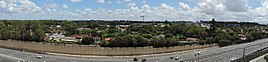
695:MacGregor suburb panorama, looking from the east.
610:Additional to the schools, there is a Robertson
291:
732:MacGregor suburb on left of Pacific Motorway.
481:, MacGregor had a population of 5,980 people.
474:, MacGregor had a population of 5,844 people.
382:, MacGregor had a population of 5,980 people.
1375:
8:
1207:
1205:
799:
797:
795:
768:MacGregor State High School side entrance.
1382:
1368:
1360:
1313:– via National Library of Australia.
1285:– via National Library of Australia.
1136:
1102:
929:Queensland Family History Society (2010),
824:
84:
63:
61:Suburb of Brisbane, Queensland, Australia
791:
698:
1297:"The C.O.D. and the Cane Prices Board"
924:
922:
417:, and Jonathan may refer to a type of
1164:from the original on 21 November 2018
996:from the original on 13 December 2021
588:Queensland Sport and Athletics Centre
335:
320:
303:
293:
7:
1154:"State and non-state school details"
1249:from the original on 26 August 2012
1223:from the original on 27 August 2020
931:Queensland schools past and present
1063:from the original on 22 April 2020
1033:from the original on 22 April 2020
970:from the original on 22 April 2020
849:from the original on 12 March 2017
780:MacGregor State High School oval.
14:
935:Queensland Family History Society
756:An eastern-side suburban street.
455:as part of their school uniform.
216:2.7 km (1.0 sq mi)
108:
1350:Brisbane City Council Suburb Map
1190:from the original on 10 May 2014
773:
761:
749:
737:
725:
713:
701:
643:Eight Mile Plains busway station
107:
100:
2442:Suburbs of the City of Brisbane
1117:Australian Bureau of Statistics
1083:Australian Bureau of Statistics
805:Australian Bureau of Statistics
744:A western-side suburban street.
681:Toohey Forest Conservation Park
622:Local residents use either the
590:are in the adjoining suburb of
992:(Video 2 minutes 43 seconds).
241:13.0 km (8 mi) S of
1:
1243:"MacGregor State High School"
1021:"Steve Webb (Graduated 1975)"
666:driver licence testing centre
413:cultivars, Elberta a type of
1269:"Do you know your Brisbane?"
708:Kessels Road, looking west.
493:MacGregor State School, 2018
162:MacGregor (centre of suburb)
1355:ourbrisbane.com – MacGregor
1345:MacGregor State High School
1213:"ACARA School Profile 2018"
1026:MacGregor State High School
963:MacGregor State High School
571:MacGregor State High School
190:2,210/km (5,740/sq mi)
51:GPX (secondary coordinates)
2458:
1087:"MacGregor (State Suburb)"
990:"Brisbane's 1973 Tornado"
933:(Version 1.01 ed.),
898:"MacGregor (entry 50174)"
353:
294:
290:
95:
83:
46:GPX (primary coordinates)
21:Map all coordinates using
1184:"MacGregor State School"
29:Download coordinates as:
639:Garden City Interchange
1340:MacGregor State School
1125:2016 Census QuickStats
1091:2011 Census QuickStats
1057:MacGregor State School
902:Queensland Place Names
873:Queensland Place Names
813:2021 Census QuickStats
696:
607:
528:MacGregor State School
494:
439:Governor of Queensland
1158:Queensland Government
906:Queensland Government
877:Queensland Government
843:Brisbane City Council
694:
624:Westfield Garden City
605:
492:
41:GPX (all coordinates)
2268:Seventeen Mile Rocks
1053:"Mission and values"
606:D. M. Henderson Park
560:27.5660°S 153.0766°E
517:27.5722°S 153.0672°E
378:, Australia. In the
2328:Upper Mount Gravatt
1085:(31 October 2012).
628:Upper Mount Gravatt
626:Shopping Centre at
584:Griffith University
555: /
512: /
429:Previously part of
331:Upper Mount Gravatt
316:Upper Mount Gravatt
311:Upper Mount Gravatt
280:Federal division(s)
268:State electorate(s)
151:27.565°S 153.0758°E
146: /
2183:Mount Gravatt East
1554:Enoggera Reservoir
697:
608:
565:-27.5660; 153.0766
522:-27.5722; 153.0672
495:
2429:
2428:
2083:Holland Park West
2023:Eight Mile Plains
1333:Queensland Places
1121:"MacGregor (SSC)"
944:978-1-921171-26-0
809:"MacGregor (SAL)"
435:William MacGregor
361:
360:
357:
356:
348:Eight Mile Plains
343:Eight Mile Plains
299:around MacGregor:
156:-27.565; 153.0758
2449:
2218:Port of Brisbane
2093:Jamboree Heights
1829:Upper Brookfield
1799:Stafford Heights
1584:Fortitude Valley
1499:Brisbane Airport
1392:City of Brisbane
1384:
1377:
1370:
1361:
1336:
1315:
1314:
1312:
1310:
1293:
1287:
1286:
1284:
1282:
1265:
1259:
1258:
1256:
1254:
1239:
1233:
1232:
1230:
1228:
1209:
1200:
1199:
1197:
1195:
1180:
1174:
1173:
1171:
1169:
1150:
1141:
1140:
1135:
1133:
1131:
1119:(27 June 2017).
1113:
1107:
1106:
1101:
1099:
1097:
1079:
1073:
1072:
1070:
1068:
1059:. 13 June 2014.
1049:
1043:
1042:
1040:
1038:
1016:
1010:
1009:
1003:
1001:
986:
980:
979:
977:
975:
966:. 4 April 2012.
954:
948:
947:
926:
917:
916:
914:
912:
894:
888:
887:
885:
883:
865:
859:
858:
856:
854:
839:"MacGregor Ward"
835:
829:
828:
823:
821:
819:
807:(28 June 2022).
801:
777:
765:
753:
741:
729:
717:
705:
671:Mimosa Creek, a
579:
578:
576:
575:
574:
572:
567:
566:
561:
556:
553:
552:
551:
548:
536:
535:
533:
532:
531:
529:
524:
523:
518:
513:
510:
509:
508:
505:
401:) and Scottish (
372:City of Brisbane
292:
255:City of Brisbane
170:
169:
167:
166:
165:
163:
158:
157:
152:
147:
144:
143:
142:
139:
111:
110:
104:
88:
79:
69:
64:
2457:
2456:
2452:
2451:
2450:
2448:
2447:
2446:
2432:
2431:
2430:
2425:
2387:
2308:Sunnybank Hills
1939:Capalaba West (
1874:
1868:
1669:Lake Manchester
1574:Fig Tree Pocket
1489:Bridgeman Downs
1404:
1398:
1390:Suburbs of the
1388:
1327:
1324:
1319:
1318:
1308:
1306:
1295:
1294:
1290:
1280:
1278:
1267:
1266:
1262:
1252:
1250:
1241:
1240:
1236:
1226:
1224:
1211:
1210:
1203:
1193:
1191:
1182:
1181:
1177:
1167:
1165:
1160:. 9 July 2018.
1152:
1151:
1144:
1129:
1127:
1115:
1114:
1110:
1095:
1093:
1081:
1080:
1076:
1066:
1064:
1051:
1050:
1046:
1036:
1034:
1018:
1017:
1013:
999:
997:
988:
987:
983:
973:
971:
956:
955:
951:
945:
928:
927:
920:
910:
908:
896:
895:
891:
881:
879:
867:
866:
862:
852:
850:
837:
836:
832:
817:
815:
803:
802:
793:
788:
781:
778:
769:
766:
757:
754:
745:
742:
733:
730:
721:
718:
709:
706:
689:
600:
570:
568:
564:
562:
558:
557:
554:
549:
546:
544:
542:
541:
527:
525:
521:
519:
515:
514:
511:
506:
503:
501:
499:
498:
487:
461:
427:
388:
257:
187: • Density
161:
159:
155:
153:
149:
148:
145:
140:
137:
135:
133:
132:
122:
121:
120:
119:
118:
117:
116:
112:
91:
71:
70:
67:
62:
59:
58:
57:
56:
55:
12:
11:
5:
2455:
2453:
2445:
2444:
2434:
2433:
2427:
2426:
2424:
2423:
2421:Moreton Island
2418:
2413:
2408:
2403:
2397:
2395:
2389:
2388:
2386:
2385:
2380:
2375:
2370:
2365:
2360:
2355:
2350:
2345:
2340:
2335:
2330:
2325:
2320:
2315:
2310:
2305:
2300:
2295:
2290:
2285:
2283:South Brisbane
2280:
2275:
2270:
2265:
2260:
2255:
2250:
2245:
2240:
2235:
2230:
2225:
2220:
2215:
2210:
2205:
2200:
2195:
2190:
2185:
2180:
2175:
2170:
2165:
2160:
2155:
2150:
2145:
2140:
2135:
2130:
2125:
2120:
2115:
2110:
2105:
2103:Kangaroo Point
2100:
2095:
2090:
2085:
2080:
2075:
2070:
2065:
2060:
2055:
2050:
2045:
2040:
2035:
2030:
2025:
2020:
2015:
2010:
2005:
2000:
1995:
1990:
1985:
1980:
1978:Coopers Plains
1975:
1970:
1965:
1960:
1955:
1953:Carina Heights
1950:
1945:
1936:
1931:
1926:
1921:
1916:
1911:
1906:
1901:
1896:
1891:
1886:
1880:
1878:
1876:Brisbane River
1870:
1869:
1867:
1866:
1861:
1856:
1851:
1846:
1844:Wavell Heights
1841:
1836:
1831:
1826:
1821:
1816:
1811:
1806:
1801:
1796:
1791:
1786:
1781:
1776:
1771:
1766:
1761:
1756:
1754:Pinjarra Hills
1751:
1749:Petrie Terrace
1746:
1741:
1736:
1731:
1726:
1721:
1716:
1711:
1706:
1701:
1699:Mount Coot-tha
1696:
1691:
1686:
1681:
1676:
1671:
1666:
1661:
1656:
1651:
1646:
1641:
1636:
1631:
1626:
1621:
1616:
1611:
1606:
1601:
1596:
1591:
1586:
1581:
1576:
1571:
1566:
1561:
1556:
1551:
1546:
1541:
1536:
1531:
1529:Chermside West
1526:
1521:
1516:
1511:
1506:
1501:
1496:
1491:
1486:
1481:
1476:
1471:
1466:
1461:
1456:
1451:
1446:
1441:
1436:
1431:
1426:
1421:
1416:
1410:
1408:
1406:Brisbane River
1400:
1399:
1389:
1387:
1386:
1379:
1372:
1364:
1358:
1357:
1352:
1347:
1342:
1337:
1323:
1322:External links
1320:
1317:
1316:
1288:
1260:
1234:
1201:
1175:
1142:
1108:
1074:
1044:
1011:
981:
949:
943:
918:
889:
860:
830:
790:
789:
787:
784:
783:
782:
779:
772:
770:
767:
760:
758:
755:
748:
746:
743:
736:
734:
731:
724:
722:
719:
712:
710:
707:
700:
688:
685:
659:Coopers Plains
599:
596:
486:
483:
460:
457:
426:
423:
387:
384:
366:is a southern
359:
358:
355:
354:
351:
350:
345:
340:
334:
333:
328:
325:
319:
318:
313:
308:
302:
301:
288:
287:
282:
276:
275:
270:
264:
263:
260:MacGregor Ward
252:
246:
245:
239:
235:
234:
224:
218:
217:
214:
210:
209:
206:
200:
199:
196:
192:
191:
188:
184:
183:
176:
172:
171:
130:
124:
123:
114:
113:
106:
105:
99:
98:
97:
96:
93:
92:
89:
81:
80:
60:
54:
53:
48:
43:
38:
32:
26:
19:
18:
17:
13:
10:
9:
6:
4:
3:
2:
2454:
2443:
2440:
2439:
2437:
2422:
2419:
2417:
2414:
2412:
2409:
2407:
2404:
2402:
2399:
2398:
2396:
2394:
2390:
2384:
2381:
2379:
2376:
2374:
2371:
2369:
2366:
2364:
2363:Woolloongabba
2361:
2359:
2356:
2354:
2351:
2349:
2346:
2344:
2341:
2339:
2336:
2334:
2331:
2329:
2326:
2324:
2321:
2319:
2316:
2314:
2311:
2309:
2306:
2304:
2301:
2299:
2296:
2294:
2293:Stones Corner
2291:
2289:
2286:
2284:
2281:
2279:
2278:Sinnamon Park
2276:
2274:
2271:
2269:
2266:
2264:
2261:
2259:
2256:
2254:
2251:
2249:
2246:
2244:
2241:
2239:
2236:
2234:
2231:
2229:
2226:
2224:
2221:
2219:
2216:
2214:
2211:
2209:
2206:
2204:
2201:
2199:
2196:
2194:
2191:
2189:
2186:
2184:
2181:
2179:
2178:Mount Gravatt
2176:
2174:
2171:
2169:
2168:Mount Ommaney
2166:
2164:
2161:
2159:
2156:
2154:
2151:
2149:
2146:
2144:
2141:
2139:
2136:
2134:
2131:
2129:
2126:
2124:
2121:
2119:
2116:
2114:
2111:
2109:
2106:
2104:
2101:
2099:
2096:
2094:
2091:
2089:
2086:
2084:
2081:
2079:
2076:
2074:
2073:Highgate Hill
2071:
2069:
2066:
2064:
2061:
2059:
2056:
2054:
2051:
2049:
2046:
2044:
2041:
2039:
2036:
2034:
2031:
2029:
2026:
2024:
2021:
2019:
2018:East Brisbane
2016:
2014:
2011:
2009:
2006:
2004:
2001:
1999:
1996:
1994:
1991:
1989:
1986:
1984:
1981:
1979:
1976:
1974:
1971:
1969:
1966:
1964:
1961:
1959:
1956:
1954:
1951:
1949:
1946:
1944:
1942:
1937:
1935:
1932:
1930:
1927:
1925:
1922:
1920:
1917:
1915:
1912:
1910:
1907:
1905:
1902:
1900:
1897:
1895:
1892:
1890:
1887:
1885:
1882:
1881:
1879:
1877:
1871:
1865:
1862:
1860:
1857:
1855:
1852:
1850:
1847:
1845:
1842:
1840:
1837:
1835:
1832:
1830:
1827:
1825:
1822:
1820:
1817:
1815:
1812:
1810:
1807:
1805:
1802:
1800:
1797:
1795:
1792:
1790:
1787:
1785:
1782:
1780:
1777:
1775:
1772:
1770:
1767:
1765:
1762:
1760:
1757:
1755:
1752:
1750:
1747:
1745:
1742:
1740:
1737:
1735:
1732:
1730:
1727:
1725:
1722:
1720:
1717:
1715:
1712:
1710:
1707:
1705:
1702:
1700:
1697:
1695:
1692:
1690:
1687:
1685:
1682:
1680:
1677:
1675:
1672:
1670:
1667:
1665:
1662:
1660:
1657:
1655:
1654:Kenmore Hills
1652:
1650:
1647:
1645:
1642:
1640:
1637:
1635:
1632:
1630:
1627:
1625:
1624:Indooroopilly
1622:
1620:
1617:
1615:
1612:
1610:
1607:
1605:
1602:
1600:
1597:
1595:
1592:
1590:
1587:
1585:
1582:
1580:
1577:
1575:
1572:
1570:
1567:
1565:
1562:
1560:
1559:England Creek
1557:
1555:
1552:
1550:
1547:
1545:
1542:
1540:
1537:
1535:
1532:
1530:
1527:
1525:
1522:
1520:
1517:
1515:
1512:
1510:
1507:
1505:
1502:
1500:
1497:
1495:
1492:
1490:
1487:
1485:
1484:Bracken Ridge
1482:
1480:
1477:
1475:
1472:
1470:
1467:
1465:
1462:
1460:
1457:
1455:
1452:
1450:
1447:
1445:
1442:
1440:
1437:
1435:
1432:
1430:
1427:
1425:
1422:
1420:
1417:
1415:
1412:
1411:
1409:
1407:
1401:
1397:
1393:
1385:
1380:
1378:
1373:
1371:
1366:
1365:
1362:
1356:
1353:
1351:
1348:
1346:
1343:
1341:
1338:
1334:
1330:
1326:
1325:
1321:
1304:
1303:
1302:The Telegraph
1298:
1292:
1289:
1276:
1275:
1270:
1264:
1261:
1248:
1244:
1238:
1235:
1222:
1218:
1214:
1208:
1206:
1202:
1189:
1185:
1179:
1176:
1163:
1159:
1155:
1149:
1147:
1143:
1139:
1126:
1122:
1118:
1112:
1109:
1105:
1092:
1088:
1084:
1078:
1075:
1062:
1058:
1054:
1048:
1045:
1032:
1028:
1027:
1022:
1019:Webb, Steve.
1015:
1012:
1007:
995:
991:
985:
982:
969:
965:
964:
959:
953:
950:
946:
940:
936:
932:
925:
923:
919:
907:
903:
899:
893:
890:
878:
874:
870:
864:
861:
848:
844:
840:
834:
831:
827:
814:
810:
806:
800:
798:
796:
792:
785:
776:
771:
764:
759:
752:
747:
740:
735:
728:
723:
716:
711:
704:
699:
693:
686:
684:
682:
678:
677:Bulimba Creek
674:
669:
667:
662:
660:
656:
652:
648:
644:
640:
635:
633:
629:
625:
620:
617:
613:
604:
597:
595:
593:
589:
585:
581:
577:
538:
534:
491:
484:
482:
480:
475:
473:
468:
466:
458:
456:
454:
451:
446:
442:
440:
436:
432:
424:
422:
420:
416:
412:
408:
404:
400:
396:
391:
385:
383:
381:
377:
373:
369:
365:
352:
349:
346:
344:
341:
339:
336:
332:
329:
326:
324:
321:
317:
314:
312:
309:
307:
304:
300:
298:
289:
286:
283:
281:
277:
274:
271:
269:
265:
261:
256:
253:
251:
247:
244:
240:
236:
232:
228:
225:
223:
219:
215:
211:
207:
205:
201:
197:
193:
189:
185:
181:
177:
173:
168:
131:
129:
125:
103:
94:
87:
82:
78:
74:
65:
52:
49:
47:
44:
42:
39:
37:
34:
33:
31:
30:
25:
24:OpenStreetMap
22:
16:
2378:Yeerongpilly
2132:
2078:Holland Park
1940:
1884:Acacia Ridge
1873:South of the
1834:Upper Kedron
1734:Nudgee Beach
1704:Mount Crosby
1644:Kelvin Grove
1634:Karana Downs
1564:Everton Park
1504:Brisbane CBD
1444:Auchenflower
1403:North of the
1332:
1307:. Retrieved
1300:
1291:
1279:. Retrieved
1272:
1263:
1251:. Retrieved
1237:
1225:. Retrieved
1192:. Retrieved
1178:
1166:. Retrieved
1128:. Retrieved
1124:
1111:
1094:. Retrieved
1090:
1077:
1065:. Retrieved
1056:
1047:
1035:. Retrieved
1024:
1014:
1004:– via
998:. Retrieved
984:
972:. Retrieved
961:
958:"Our school"
952:
930:
909:. Retrieved
901:
892:
880:. Retrieved
872:
863:
851:. Retrieved
842:
833:
816:. Retrieved
812:
670:
663:
636:
621:
609:
582:
539:
496:
476:
469:
462:
459:Demographics
447:
443:
437:who was the
428:
392:
389:
363:
362:
295:
243:Brisbane CBD
178:5,980 (
28:
27:
20:
15:
2416:Moreton Bay
2406:Cowan Cowan
2393:Moreton Bay
2373:Wynnum West
2263:Seven Hills
2198:Norman Park
2163:Morningside
2158:Middle Park
2048:Greenslopes
2038:Forest Lake
2028:Ellen Grove
2013:Dutton Park
1998:Doolandella
1934:Cannon Hill
1899:Archerfield
1784:Spring Hill
1779:Shorncliffe
1599:Gordon Park
1569:Ferny Grove
1519:Chapel Hill
1479:Bowen Hills
1454:Banks Creek
1329:"MacGregor"
1274:Sunday Mail
1253:21 November
1194:21 November
1168:21 November
818:28 February
612:Scout Group
563: /
550:153°04′36″E
520: /
507:153°04′02″E
479:2021 census
472:2016 census
465:2011 census
403:Blairgowrie
380:2021 census
204:Postcode(s)
195:Established
180:2021 census
154: /
141:153°04′33″E
128:Coordinates
2313:Tarragindi
2233:Riverhills
2148:Manly West
2043:Graceville
1764:Pullenvale
1744:Paddington
1689:Mitchelton
1579:Fitzgibbon
1544:Eagle Farm
1514:Carseldine
1509:Brookfield
1469:Bellbowrie
1449:Bald Hills
1396:Queensland
1309:27 January
1281:27 January
1227:28 January
1096:26 October
911:20 January
882:26 January
786:References
598:Facilities
569: (
547:27°33′58″S
526: (
504:27°34′20″S
407:Carnoustie
399:Gaillardia
376:Queensland
175:Population
160: (
138:27°33′54″S
77:Queensland
2411:Kooringal
2353:Willawong
2303:Sunnybank
2258:Salisbury
2243:Rochedale
2238:Robertson
2228:Richlands
2213:Parkinson
2153:Mansfield
2138:Mackenzie
2133:MacGregor
2118:Larapinta
2108:Karawatha
2063:Heathwood
2058:Hawthorne
2033:Fairfield
1988:Coorparoo
1958:Carindale
1929:Camp Hill
1924:Calamvale
1859:Wooloowin
1814:Teneriffe
1724:Northgate
1714:Newmarket
1589:Gaythorne
1534:Clayfield
1524:Chermside
673:tributary
651:Sunnybank
632:Sunnybank
485:Education
450:MacGregor
431:Sunnybank
386:Geography
364:MacGregor
338:Sunnybank
327:MacGregor
323:Robertson
231:UTC+10:00
222:Time zone
115:MacGregor
68:MacGregor
2436:Category
2348:Westlake
2343:West End
2338:Wakerley
2323:Tingalpa
2318:Tennyson
2288:Stretton
2273:Sherwood
2188:Murarrie
2173:Moorooka
2098:Jindalee
2003:Drewvale
1963:Chandler
1904:Balmoral
1894:Annerley
1889:Algester
1864:Zillmere
1839:Virginia
1794:Stafford
1789:St Lucia
1774:Sandgate
1769:Red Hill
1759:Pinkenba
1719:Newstead
1709:New Farm
1679:McDowall
1674:Lutwyche
1609:Hamilton
1549:Enoggera
1494:Brighton
1474:Boondall
1434:Ashgrove
1419:Alderley
1247:Archived
1221:Archived
1188:Archived
1162:Archived
1130:22 April
1067:22 April
1061:Archived
1037:22 April
1031:Archived
1000:22 April
994:Archived
974:22 April
968:Archived
853:12 March
847:Archived
586:and the
238:Location
73:Brisbane
2383:Yeronga
2358:Wishart
2253:Runcorn
2248:Rocklea
2223:Ransome
2208:Pallara
2068:Hemmant
2053:Gumdale
1983:Corinda
1968:Chelmer
1941:defunct
1919:Burbank
1914:Bulimba
1909:Belmont
1854:Windsor
1849:Wilston
1824:Toowong
1819:The Gap
1809:Taringa
1694:Moggill
1659:Keperra
1649:Kenmore
1629:Kalinga
1619:Herston
1594:Geebung
1424:Anstead
1006:YouTube
687:Gallery
675:to the
647:Altandi
630:or the
616:Netball
477:In the
470:In the
463:In the
425:History
395:Freesia
370:in the
297:Suburbs
285:Moreton
75:,
2401:Bulwer
2368:Wynnum
2298:Sumner
2193:Nathan
2128:Lytton
2113:Kuraby
2008:Durack
1973:Chuwar
1948:Carina
1804:Taigum
1739:Nundah
1729:Nudgee
1684:Milton
1639:Kedron
1614:Hendra
1604:Grange
1539:Deagon
1464:Bardon
1439:Aspley
1414:Albion
941:
655:Banoon
592:Nathan
453:tartan
368:suburb
306:Nathan
273:Toohey
250:LGA(s)
2333:Wacol
2203:Oxley
2143:Manly
2088:Inala
1993:Darra
1664:Kholo
1459:Banyo
1429:Ascot
419:apple
415:peach
2123:Lota
1311:2018
1283:2018
1255:2018
1229:2020
1196:2018
1170:2018
1132:2020
1098:2014
1069:2020
1039:2020
1002:2020
976:2020
939:ISBN
913:2018
884:2020
855:2017
820:2023
411:plum
227:AEST
213:Area
208:4109
198:1967
657:or
641:or
36:KML
2438::
1394:,
1331:.
1299:.
1271:.
1245:.
1219:.
1215:.
1204:^
1186:.
1156:.
1145:^
1123:.
1089:.
1055:.
1029:.
1023:.
960:.
937:,
921:^
904:.
900:.
875:.
871:.
845:.
841:.
811:.
794:^
683:.
668:.
661:.
653:,
649:,
594:.
405:,
397:,
374:,
1943:)
1383:e
1376:t
1369:v
1257:.
1231:.
1198:.
1172:.
1134:.
1100:.
1071:.
1041:.
1008:.
978:.
915:.
886:.
857:.
822:.
573:)
530:)
262:)
258:(
233:)
229:(
182:)
164:)
Text is available under the Creative Commons Attribution-ShareAlike License. Additional terms may apply.