29:
423:, which influenced the structure of the riverbed. The upper section of the watershed is marked by a series of pools and fast-flowing riffles. The character of the river downstream of the moraines is markedly different, with a relatively wide floodplain, large meanders and erosion-prone sandy banks. Its principal tributaries are Panther, Walnut and Money creeks, and the
639:
Historical and
Statistical Information Respecting the History, Condition and Prospects of the Indian Tribes of the United States Collected and Prepared Under the Direction of the Bureau of Indian Affairs, Per Act of Congress of March 3d,
414:
The river flows through three natural divisions, including the Grand
Prairie, Upper Mississippi River and Illinois Bottomlands, and Illinois and Mississippi Sand Areas. Early in its life, several thousand years ago following the
160:
82:
717:
712:
482:
702:
692:
697:
490:
656:
459:. In 1853 a group of 200 Kickapoo still lived along the river but they were expected to move to a reservation in Missouri the next year.
355:
in the United States. The river itself maintains some of the highest quality streams in the state and provides habitat for 60-70 native
270:
522:
707:
539:
28:
404:
400:
289:
493:, the area provides opportunities for fishing, canoeing, hiking, hunting and general interaction with nature.
555:
462:
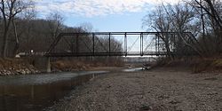
There are only a few villages along or near the
Mackinaw River. These include (beginning up stream): Sibley,
276:
502:
392:
396:
599:
236:
424:
388:
64:
643:
571:
416:
368:
316:
467:
311:
351:
covers approximately 1,136 square miles (3,000 km), and contains some of the most productive
471:
360:
146:
664:
306:
352:
34:
463:
436:
384:
68:
543:
440:
408:
356:
455:
peoples also fished, hunted and lived along the river for several centuries, through the
577:. Champaign, IL: Prairie Research Institute, University of Illinois at Urbana Champaign
475:
456:
348:
336:
686:
535:
U.S. Geological Survey. National
Hydrography Dataset high-resolution flowline data.
478:
in the region during the 1850s, which diminished the importance of river transport.
638:
523:"USGS Current Conditions for USGS 05568000 MACKINAW RIVER NEAR GREEN VALLEY, IL"
127:
486:
444:
340:
301:
142:
176:
162:
98:
84:
332:
572:"Freshwater Mussels of the Mackinaw River: INHS Technical Report 2011 (45)"
556:
U.S. Geological Survey
Geographic Names Information System: Mackinaw River
536:
420:
344:
448:
452:
265:
Mackinaw River → Illinois → Mississippi → Gulf of Mexico
570:
Price, Alison L.; Shasteen, Diane K.; Bales, Sarah A.
489:
along the river in
Tazewell County. Operated by the
407:
before flowing into the
Illinois River just south of
403:. It continues west and then southwestward through
391:. From its headwaters the river flows west through
269:
261:
256:
242:
230:
222:
210:
200:
152:
136:
126:
74:
58:
50:
41:
21:
474:. Each was laid out prior to the arrival of the
439:lived in the area 1,700 to 2,100 years ago. The
657:"Mackinaw River - State Fish and Wildlife Area"
628:. Minneapolis: University of Minnesota Press.
8:
395:, where it provides drainage to part of the
483:Mackinaw River State Fish and Wildlife Area
661:Illinois Department of Natural Resources
626:A Concise Dictionary of Minnesota Ojibwe
594:
592:
491:Illinois Department of Natural Resources
624:Nichols, John D.; Nyholm, Earl (1995).
514:
565:
563:
18:
7:
718:Rivers of Woodford County, Illinois
713:Rivers of Tazewell County, Illinois
331:is a 130-mile-long (210 km)
14:
703:Rivers of McLean County, Illinois
693:Tributaries of the Illinois River
27:
698:Rivers of Ford County, Illinois
383:The Mackinaw River begins near
485:is a 1,448-acre (586 ha)
154: • coordinates
76: • coordinates
1:
359:species and 25-30 species of
145:with the Illinois River near
42:Physical characteristics
604:The Great Rivers Partnership
202: • elevation
317:GPX (secondary coordinates)
232: • location
138: • location
60: • location
734:
244: • average
419:, it cut through several
363:. Its name, also spelled
312:GPX (primary coordinates)
287:Map all coordinates using
252:
218:
214:130 mi (210 km)
177:40.5517055°N 89.7323284°W
122:
99:40.5889233°N 88.3664421°W
46:
26:
295:Download coordinates as:
206:443 ft (135 m)
546:, accessed May 13, 2011
503:List of Illinois rivers
399:metropolitan area, and
182:40.5517055; -89.7323284
104:40.5889233; -88.3664421
367:, is derived from the
237:Green Valley, Illinois
425:Little Mackinaw River
307:GPX (all coordinates)
110:Mackinaw River origin
646:, volume 3, page 592
644:Henry R. Schoolcraft
417:Wisconsin glaciation
188:Mackinaw River mouth
33:Mackinaw River near
667:on December 8, 2015
257:Basin features
248:772 cu/ft. per sec.
172: /
94: /
708:Rivers of Illinois
542:2012-03-29 at the
397:Bloomington–Normal
375:meaning "turtle".
147:Mapleton, Illinois
353:agricultural land
282:
281:
35:Tremont, Illinois
725:
677:
676:
674:
672:
663:. Archived from
653:
647:
636:
630:
629:
621:
615:
614:
612:
610:
600:"Mackinaw River"
596:
587:
586:
584:
582:
576:
567:
558:
553:
547:
537:The National Map
533:
527:
526:
519:
437:Hopewell culture
385:Sibley, Illinois
245:
233:
196:
195:
193:
192:
191:
189:
184:
183:
178:
173:
170:
169:
168:
165:
118:
117:
115:
114:
113:
111:
106:
105:
100:
95:
92:
91:
90:
87:
77:
69:Sibley, Illinois
61:
31:
19:
733:
732:
728:
727:
726:
724:
723:
722:
683:
682:
681:
680:
670:
668:
655:
654:
650:
637:
633:
623:
622:
618:
608:
606:
598:
597:
590:
580:
578:
574:
569:
568:
561:
554:
550:
544:Wayback Machine
534:
530:
521:
520:
516:
511:
499:
433:
405:Tazewell County
401:Woodford County
381:
325:
324:
323:
322:
321:
243:
231:
203:
187:
185:
181:
179:
175:
174:
171:
166:
163:
161:
159:
158:
155:
139:
109:
107:
103:
101:
97:
96:
93:
88:
85:
83:
81:
80:
75:
59:
37:
17:
12:
11:
5:
731:
729:
721:
720:
715:
710:
705:
700:
695:
685:
684:
679:
678:
648:
631:
616:
588:
559:
548:
528:
513:
512:
510:
507:
506:
505:
498:
495:
435:People of the
432:
429:
380:
377:
337:Illinois River
329:Mackinaw River
320:
319:
314:
309:
304:
298:
292:
285:
284:
283:
280:
279:
274:
267:
266:
263:
259:
258:
254:
253:
250:
249:
246:
240:
239:
234:
228:
227:
224:
220:
219:
216:
215:
212:
208:
207:
204:
201:
198:
197:
156:
153:
150:
149:
140:
137:
134:
133:
130:
124:
123:
120:
119:
78:
72:
71:
62:
56:
55:
52:
48:
47:
44:
43:
39:
38:
32:
24:
23:
22:Mackinaw River
15:
13:
10:
9:
6:
4:
3:
2:
730:
719:
716:
714:
711:
709:
706:
704:
701:
699:
696:
694:
691:
690:
688:
666:
662:
658:
652:
649:
645:
641:
635:
632:
627:
620:
617:
605:
601:
595:
593:
589:
573:
566:
564:
560:
557:
552:
549:
545:
541:
538:
532:
529:
524:
518:
515:
508:
504:
501:
500:
496:
494:
492:
488:
484:
479:
477:
473:
469:
465:
460:
458:
454:
450:
446:
442:
438:
430:
428:
426:
422:
418:
412:
410:
406:
402:
398:
394:
393:McLean County
390:
386:
378:
376:
374:
370:
366:
362:
358:
354:
350:
346:
342:
338:
334:
330:
318:
315:
313:
310:
308:
305:
303:
300:
299:
297:
296:
291:
290:OpenStreetMap
288:
278:
275:
272:
268:
264:
260:
255:
251:
247:
241:
238:
235:
229:
225:
221:
217:
213:
209:
205:
199:
194:
157:
151:
148:
144:
141:
135:
131:
129:
125:
121:
116:
79:
73:
70:
66:
63:
57:
53:
49:
45:
40:
36:
30:
25:
20:
669:. Retrieved
665:the original
660:
651:
634:
625:
619:
607:. Retrieved
603:
579:. Retrieved
551:
531:
517:
480:
461:
434:
413:
382:
372:
364:
328:
326:
294:
293:
286:
671:December 4,
609:December 4,
581:December 4,
389:Ford County
379:Description
262:Progression
180: /
102: /
65:Ford County
687:Categories
509:References
487:state park
445:Potawatomi
341:U.S. state
186: (
167:89°43′56″W
164:40°33′06″N
143:Confluence
108: (
89:88°21′59″W
86:40°35′20″N
468:Lexington
349:watershed
333:tributary
223:Discharge
540:Archived
497:See also
476:railroad
472:Mackinaw
449:Chippewa
441:Kickapoo
421:moraines
373:mikinaak
365:Mackinac
345:Illinois
67:east of
431:History
361:mussels
339:in the
335:of the
470:, and
464:Colfax
453:Ottawa
451:, and
369:Ojibwe
347:. Its
277:403283
226:
211:Length
132:
54:
51:Source
575:(PDF)
457:1830s
409:Pekin
387:, in
371:word
128:Mouth
16:River
673:2015
640:1847
611:2015
583:2015
481:The
357:fish
327:The
271:GNIS
447:,
343:of
302:KML
689::
659:.
642:,
602:.
591:^
562:^
466:,
443:,
427:.
411:.
273:ID
675:.
613:.
585:.
525:.
190:)
112:)
Text is available under the Creative Commons Attribution-ShareAlike License. Additional terms may apply.