566:. Chinese and foreign investors flooded the area, all in search of lucrative teak and business transactions. Missionaries came and built Chiang Mai’s first church along the eastern bank of the river, an area set aside for foreign residents by the ruling government who occupied the safe, flood-free western banks. Land along the banks, including its islands, were repurposed, such as a small island in the river that was donated to an American missionary Dr. James McKean by Chao Inthawarorot Suriyawong in 1907 to become a leper colony. With no cure for leprosy until the 1980s, lepers found relief in their sanctuary from social criticism, many of whom remain at the McKean Rehabilitation Centre today.
1452:
1389:
1440:
1428:
1467:
1413:
1377:
1401:
56:
40:
1439:
1451:
533:
Evidence shows that habitation along the Ping River dates back to 1500 BCE. At that time it controlled trading routes between Yunnan and the Chao Phraya basin.
1604:
1599:
1388:
1412:
439:
1584:
1466:
1540:
1427:
1120:(Placement in tributary tree is approximate, geographical coordinates unavailable due to inaccurate station data from Royal Irrigation Department)
1589:
1376:
575:
1286:
1249:
1206:
1169:
1086:
1049:
1010:
973:
930:
893:
856:
808:
771:
709:
666:
629:
592:
1594:
1445:
Bhumibol Dam, 154 metres (505 ft) long, creating a reservoir with a surface area of 300 square kilometres (120 sq mi).
1512:
122:
1400:
251:
1142:(Placement in tributary tree is approximate, geographical coordinates presently undeterminable due to recently built dam)
1136:(Placement in tributary tree is approximate, geographical coordinates presently undeterminable due to recently built dam)
1579:
1358:
551:
as his capital before abandoning it following nearly a decade of floods, finally moving kilometres north to establish
1240:(Placement in tributary tree is approximate, geographical coordinates unavailable due to poor satellite resolution)
1160:(Placement in tributary tree is approximate, geographical coordinates unavailable due to poor satellite resolution)
1154:(Placement in tributary tree is approximate, geographical coordinates unavailable due to poor satellite resolution)
1148:(Placement in tributary tree is approximate, geographical coordinates unavailable due to poor satellite resolution)
1130:(Placement in tributary tree is approximate, geographical coordinates unavailable due to poor satellite resolution)
964:(Placement in tributary tree is approximate, geographical coordinates unavailable due to poor satellite resolution)
842:(Placement in tributary tree is approximate, geographical coordinates unavailable due to poor satellite resolution)
700:(Placement in tributary tree is approximate, geographical coordinates unavailable due to poor satellite resolution)
170:
514:
126:
96:
1362:
757:
473:
461:
745:
237:
100:
581:
623:
1004:
967:
660:
586:
1334:
The greater Ping Basin, i.e. the basin of the entire Ping river system including its tributary the
1157:
961:
887:
753:
498:
494:
397:
156:
84:
1151:
1127:
1117:
393:
1491:
1419:
1346:
1145:
1133:
1080:
1043:
850:
417:
1280:
697:
389:
1200:
1139:
839:
765:
749:
486:
1328:
1163:
845:
802:
482:
221:
543:, turned south to create an alternative "silk road" along the Ping River itself and captured
556:
506:
369:
118:
114:
88:
1520:
1324:
490:
1573:
548:
540:
456:
430:
1342:
518:
510:
326:
92:
55:
1243:
544:
413:
365:
233:
216:
1335:
924:
738:
703:
552:
502:
401:
110:
45:
1555:
1542:
1301:
1288:
1264:
1251:
1221:
1208:
1184:
1171:
1101:
1088:
1064:
1051:
1025:
1012:
988:
975:
945:
932:
908:
895:
871:
858:
823:
810:
786:
773:
724:
711:
681:
668:
644:
631:
607:
594:
266:
253:
185:
172:
1237:
478:
39:
74:
17:
1458:
1338:, drains a total of 44,688 square kilometres (17,254 sq mi).
536:
1331:, draining 33,896 square kilometres (13,087 sq mi) of land.
444:
60:
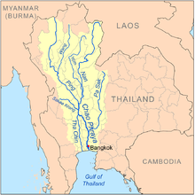
Map of the Chao Phraya River drainage basin showing the Ping River
563:
1457:
Wang River, the main tributary of the Ping, flowing through
1418:
A Ping tributary, the Chaem River flows through the town of
1472:
Confluence of the Ping with the Nan River at Nakhon Sawan
547:
in 1281. Following his successful conquest, he created
1382:
Bathing elephants in the Taeng River, a Ping tributary
562:
In the 20th century, the Ping River became a part of
407:
383:
375:
361:
356:
342:
332:
320:
312:
300:
292:
282:
243:
227:
215:
201:
162:
149:
141:
132:
106:
80:
70:
65:
32:
1513:"Mae Ping River: Lifeline of Chiangmai Province"
8:
1406:Ping River, northern outskirts of Chiang Mai
481:, is one of the two main tributaries of the
1433:Ping River, upstream from the Bhumibol Dam
525:in Thai), it forms the Chao Phraya River.
54:
348:2,302 m/s (81,300 cu ft/s)
27:Major Tributary of the Chao Phraya River
1483:
1372:
304:44,688 km (17,254 sq mi)
472:
338:265 m/s (9,400 cu ft/s)
29:
1323:The Ping Basin is one of the largest
455:
7:
1605:Tributaries of the Chao Phraya River
1600:Geography of Kamphaeng Phet province
576:Tributaries of the Chao Phraya River
517:. At the confluence with the Nan at
505:, it flows through the provinces of
1341:The main dams in the basin are the
25:
1585:Geography of Chiang Mai province
1517:Chiangmai and Chiangrai Magazine
1465:
1450:
1438:
1426:
1411:
1399:
1387:
1375:
38:
1394:Ping River north of Chiang Mai
1357:The Ping itself originates in
245: • coordinates
164: • coordinates
1:
1590:Geography of Lamphun province
539:, a ruler and conqueror from
133:Physical characteristics
284: • elevation
207:1,700 m (5,600 ft)
203: • elevation
1359:Huai Nam Dang National Park
445:
322: • location
229: • location
151: • location
1621:
1492:"Chiang Dao National Park"
573:
465:
344: • maximum
334: • average
1595:Geography of Tak province
434:
352:
308:
296:658 km (409 mi)
211:
137:
53:
37:
409: • right
385: • left
1519:. 2008. Archived from
1363:Mae Ping National Park
555:as the capital of the
474:[nâːmmɛ̂ː.pīŋ]
457:[mɛ̂ː.náːmpīŋ]
288:25 m (82 ft)
1494:. Thai Forest Booking
1329:Chao Phraya Watershed
1302:19.15306°N 99.01222°E
1265:19.10222°N 98.94694°E
1222:18.92028°N 98.96722°E
1185:18.89111°N 98.97278°E
1102:18.53972°N 98.94139°E
1065:18.54250°N 98.93528°E
1026:18.54944°N 98.86028°E
989:18.50139°N 98.85111°E
946:18.42861°N 98.70222°E
909:18.37000°N 98.68194°E
872:18.18861°N 98.63389°E
824:17.68806°N 98.75028°E
787:17.03833°N 99.06667°E
725:17.12361°N 99.05972°E
682:16.74611°N 99.21806°E
645:16.68389°N 99.27111°E
608:16.49500°N 99.49889°E
186:19.81250°N 98.83889°E
744:Tributaries include
1552: /
1298: /
1283:(Joins the Ping at
1261: /
1246:(Joins the Ping at
1218: /
1203:(Joins the Ping at
1181: /
1166:(Joins the Ping at
1098: /
1061: /
1046:(Joins the Ping at
1022: /
1007:(Joins the Khan at
985: /
970:(Joins the Ping at
942: /
927:(Joins the Ping at
905: /
890:(Joins the Ping at
868: /
853:(Joins the Ping at
820: /
805:(Joins the Ping at
783: /
768:(Joins the Ping at
721: /
706:(Joins the Ping at
678: /
663:(Joins the Ping at
641: /
626:(Joins the Ping at
604: /
589:(Joins the Ping at
499:Chiang Mai province
495:Chiang Dao district
485:. It originates at
357:Basin features
263: /
182: /
1580:Rivers of Thailand
1361:and flows through
1307:19.15306; 99.01222
1270:19.10222; 98.94694
1227:18.92028; 98.96722
1190:18.89111; 98.97278
1107:18.53972; 98.94139
1070:18.54250; 98.93528
1031:18.54944; 98.86028
994:18.50139; 98.85111
951:18.42861; 98.70222
914:18.37000; 98.68194
877:18.18861; 98.63389
829:17.68806; 98.75028
792:17.03833; 99.06667
730:17.12361; 99.05972
687:16.74611; 99.21806
650:16.68389; 99.27111
613:16.49500; 99.49889
267:15.701°N 100.142°E
191:19.81250; 98.83889
1556:19.500°N 98.967°E
483:Chao Phraya River
477:) along with the
443:
423:
422:
222:Chao Phraya River
16:(Redirected from
1612:
1567:
1566:
1564:
1563:
1562:
1557:
1553:
1550:
1549:
1548:
1545:
1532:
1531:
1529:
1528:
1509:
1503:
1502:
1500:
1499:
1488:
1469:
1454:
1442:
1430:
1415:
1403:
1391:
1379:
1313:
1312:
1310:
1309:
1308:
1303:
1299:
1296:
1295:
1294:
1291:
1276:
1275:
1273:
1272:
1271:
1266:
1262:
1259:
1258:
1257:
1254:
1233:
1232:
1230:
1229:
1228:
1223:
1219:
1216:
1215:
1214:
1211:
1196:
1195:
1193:
1192:
1191:
1186:
1182:
1179:
1178:
1177:
1174:
1113:
1112:
1110:
1109:
1108:
1103:
1099:
1096:
1095:
1094:
1091:
1083:(Joins Kuang at
1076:
1075:
1073:
1072:
1071:
1066:
1062:
1059:
1058:
1057:
1054:
1037:
1036:
1034:
1033:
1032:
1027:
1023:
1020:
1019:
1018:
1015:
1000:
999:
997:
996:
995:
990:
986:
983:
982:
981:
978:
957:
956:
954:
953:
952:
947:
943:
940:
939:
938:
935:
920:
919:
917:
916:
915:
910:
906:
903:
902:
901:
898:
883:
882:
880:
879:
878:
873:
869:
866:
865:
864:
861:
835:
834:
832:
831:
830:
825:
821:
818:
817:
816:
813:
798:
797:
795:
794:
793:
788:
784:
781:
780:
779:
776:
736:
735:
733:
732:
731:
726:
722:
719:
718:
717:
714:
693:
692:
690:
689:
688:
683:
679:
676:
675:
674:
671:
656:
655:
653:
652:
651:
646:
642:
639:
638:
637:
634:
619:
618:
616:
615:
614:
609:
605:
602:
601:
600:
597:
582:Khlung River (2)
557:Kingdom of Lanna
501:. After passing
476:
471:
467:
459:
454:
450:
438:
436:
410:
386:
370:Gulf of Thailand
345:
335:
323:
278:
277:
275:
274:
273:
268:
264:
261:
260:
259:
256:
204:
197:
196:
194:
193:
192:
187:
183:
180:
179:
178:
175:
165:
152:
58:
48:in October 2020.
42:
30:
21:
1620:
1619:
1615:
1614:
1613:
1611:
1610:
1609:
1570:
1569:
1560:
1558:
1554:
1551:
1546:
1543:
1541:
1539:
1538:
1536:
1535:
1526:
1524:
1511:
1510:
1506:
1497:
1495:
1490:
1489:
1485:
1480:
1473:
1470:
1461:
1455:
1446:
1443:
1434:
1431:
1422:
1416:
1407:
1404:
1395:
1392:
1383:
1380:
1371:
1355:
1325:drainage basins
1321:
1306:
1304:
1300:
1297:
1292:
1289:
1287:
1285:
1284:
1269:
1267:
1263:
1260:
1255:
1252:
1250:
1248:
1247:
1226:
1224:
1220:
1217:
1212:
1209:
1207:
1205:
1204:
1189:
1187:
1183:
1180:
1175:
1172:
1170:
1168:
1167:
1106:
1104:
1100:
1097:
1092:
1089:
1087:
1085:
1084:
1069:
1067:
1063:
1060:
1055:
1052:
1050:
1048:
1047:
1030:
1028:
1024:
1021:
1016:
1013:
1011:
1009:
1008:
993:
991:
987:
984:
979:
976:
974:
972:
971:
950:
948:
944:
941:
936:
933:
931:
929:
928:
913:
911:
907:
904:
899:
896:
894:
892:
891:
876:
874:
870:
867:
862:
859:
857:
855:
854:
828:
826:
822:
819:
814:
811:
809:
807:
806:
791:
789:
785:
782:
777:
774:
772:
770:
769:
737:in the town of
729:
727:
723:
720:
715:
712:
710:
708:
707:
686:
684:
680:
677:
672:
669:
667:
665:
664:
649:
647:
643:
640:
635:
632:
630:
628:
627:
624:Wang Chao River
612:
610:
606:
603:
598:
595:
593:
591:
590:
578:
572:
531:
469:
452:
408:
384:
343:
333:
321:
285:
272:15.701; 100.142
271:
269:
265:
262:
257:
254:
252:
250:
249:
246:
230:
202:
190:
188:
184:
181:
176:
173:
171:
169:
168:
163:
150:
61:
49:
28:
23:
22:
15:
12:
11:
5:
1618:
1616:
1608:
1607:
1602:
1597:
1592:
1587:
1582:
1572:
1571:
1561:19.500; 98.967
1534:
1533:
1504:
1482:
1481:
1479:
1476:
1475:
1474:
1471:
1464:
1462:
1456:
1449:
1447:
1444:
1437:
1435:
1432:
1425:
1423:
1417:
1410:
1408:
1405:
1398:
1396:
1393:
1386:
1384:
1381:
1374:
1370:
1367:
1354:
1353:National Parks
1351:
1320:
1317:
1316:
1315:
1278:
1241:
1235:
1198:
1161:
1155:
1149:
1143:
1137:
1131:
1125:
1124:
1123:
1122:
1121:
1041:
1040:
1039:
1005:Wang River (2)
968:Khan River (2)
965:
959:
922:
885:
848:
843:
837:
800:
763:
762:
761:
701:
695:
661:Pra Dang River
658:
621:
587:Suan Mak River
584:
574:Main article:
571:
568:
530:
527:
515:Kamphaeng Phet
491:Daen Lao Range
421:
420:
411:
405:
404:
387:
381:
380:
377:
373:
372:
363:
359:
358:
354:
353:
350:
349:
346:
340:
339:
336:
330:
329:
324:
318:
317:
314:
310:
309:
306:
305:
302:
298:
297:
294:
290:
289:
286:
283:
280:
279:
247:
244:
241:
240:
231:
228:
225:
224:
219:
213:
212:
209:
208:
205:
199:
198:
166:
160:
159:
153:
147:
146:
143:
139:
138:
135:
134:
130:
129:
127:Banphot Phisai
123:Kamphaeng Phet
108:
104:
103:
97:Kamphaeng Phet
82:
78:
77:
72:
68:
67:
63:
62:
59:
51:
50:
44:Ping River at
43:
35:
34:
26:
24:
14:
13:
10:
9:
6:
4:
3:
2:
1617:
1606:
1603:
1601:
1598:
1596:
1593:
1591:
1588:
1586:
1583:
1581:
1578:
1577:
1575:
1568:
1565:
1523:on 2009-11-29
1522:
1518:
1514:
1508:
1505:
1493:
1487:
1484:
1477:
1468:
1463:
1460:
1453:
1448:
1441:
1436:
1429:
1424:
1421:
1414:
1409:
1402:
1397:
1390:
1385:
1378:
1373:
1368:
1366:
1364:
1360:
1352:
1350:
1348:
1344:
1339:
1337:
1332:
1330:
1326:
1318:
1311:
1282:
1279:
1274:
1245:
1242:
1239:
1236:
1231:
1202:
1199:
1194:
1165:
1162:
1159:
1158:Lai River (2)
1156:
1153:
1150:
1147:
1144:
1141:
1138:
1135:
1132:
1129:
1126:
1119:
1116:
1115:
1111:
1082:
1079:
1078:
1074:
1045:
1042:
1035:
1006:
1003:
1002:
998:
969:
966:
963:
962:Tun River (2)
960:
955:
926:
923:
918:
889:
886:
881:
852:
849:
847:
844:
841:
838:
833:
804:
801:
796:
767:
764:
759:
755:
751:
747:
743:
742:
740:
734:
705:
702:
699:
696:
691:
662:
659:
654:
625:
622:
617:
588:
585:
583:
580:
579:
577:
569:
567:
565:
560:
558:
554:
550:
549:Wiang Kum Kam
546:
542:
541:Xishuangbanna
538:
534:
528:
526:
524:
520:
516:
512:
508:
504:
500:
496:
492:
488:
484:
480:
475:
463:
462:Northern Thai
458:
449:
448:
441:
432:
428:
419:
415:
412:
406:
403:
399:
395:
391:
388:
382:
378:
374:
371:
367:
364:
360:
355:
351:
347:
341:
337:
331:
328:
325:
319:
315:
311:
307:
303:
299:
295:
291:
287:
281:
276:
248:
242:
239:
235:
232:
226:
223:
220:
218:
214:
210:
206:
200:
195:
167:
161:
158:
154:
148:
144:
140:
136:
131:
128:
124:
120:
116:
112:
109:
105:
102:
98:
94:
90:
86:
83:
79:
76:
73:
69:
64:
57:
52:
47:
41:
36:
31:
19:
1537:
1525:. Retrieved
1521:the original
1516:
1507:
1496:. Retrieved
1486:
1356:
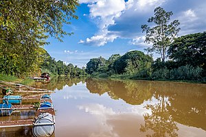
1343:Bhumibol Dam
1340:
1333:
1322:
1152:Mempin River
1128:Khanat River
1118:Sapuat River
561:
535:
532:
522:
521:(also named
519:Nakhon Sawan
446:
426:
424:
394:Kwuang River
327:Nakhon Sawan
238:Nakhon Sawan
101:Nakhon Sawan
1559: /
1347:Doi Tao Dam
1305: /
1268: /
1244:Taeng River
1225: /
1188: /
1146:Phaem River
1105: /
1068: /
1044:Kuang River
1029: /
992: /
949: /
912: /
888:Klang River
875: /
851:Chaem River
827: /
790: /
728: /
685: /
648: /
611: /
570:Tributaries
545:Haripunchai
447:Maenam Ping
418:Chaem River
414:Taeng River
376:Tributaries
366:Chao Phraya
362:Progression
270: /
258:100°08′31″E
234:Pak Nam Pho
189: /
155:Doi Thuai,
1574:Categories
1527:2009-04-02
1498:2009-05-20
1478:References
1336:Wang River
1319:Ping Basin
1293:99°00′44″E
1290:19°09′11″N
1281:Ngat River
1256:98°56′49″E
1253:19°06′08″N
1213:98°58′02″E
1210:18°55′13″N
1176:98°58′22″E
1173:18°53′28″N
1093:98°56′29″E
1090:18°32′23″N
1056:98°56′07″E
1053:18°32′33″N
1017:98°51′37″E
1014:18°32′58″N
980:98°51′04″E
977:18°30′05″N
937:98°42′08″E
934:18°25′43″N
900:98°40′55″E
897:18°22′12″N
863:98°38′02″E
860:18°11′19″N
815:98°45′01″E
812:17°41′17″N
778:99°04′00″E
775:17°02′18″N
716:99°03′35″E
713:17°07′25″N
704:Wang River
698:Raka River
673:99°13′05″E
670:16°44′46″N
636:99°16′16″E
633:16°41′02″N
599:99°29′56″E
596:16°29′42″N
553:Chiang Mai
523:Paknam Pho
503:Chiang Mai
470:pronounced
453:pronounced
427:Ping River
402:Wang River
390:Ngad River
301:Basin size
255:15°42′04″N
177:98°50′20″E
174:19°48′45″N
157:Chiang Mai
111:Chiang Mai
85:Chiang Mai
46:Chiang Mai
33:Ping River
1420:Mae Chaem
1238:Nai River
1201:Rim River
1140:Tip River
1134:San River
1081:Tha River
840:Tun River
766:Tak River
559:in 1296.
487:Doi Thuai
479:Nan River
466:น้ำแม่ปิง
435:แม่น้ำปิง
313:Discharge
145:Khun Ping
1345:and the
1164:Sa River
925:Li River
846:Pa River
803:Ko River
398:Li River
81:District
75:Thailand
66:Location
18:Mae Ping
1547:98°58′E
1544:19°30′N
1459:Lampang
1369:Gallery
1327:of the
537:Mengrai
529:History
507:Lamphun
489:in the
442::
119:San Sai
115:Saraphi
89:Lamphun
71:Country
760:Rivers
756:&
379:
316:
293:Length
142:Source
107:Cities
754:Chang
493:, in
217:Mouth
564:Siam
513:and
440:RTGS
431:Thai
425:The
758:Soi
750:Tui
739:Tak
511:Tak
93:Tak
1576::
1515:.
1365:.
1349:.
1114:)
1077:)
1001:)
752:,
748:,
746:Mo
741:)
509:,
497:,
468:,
464::
460:;
451:,
437:,
433::
416:,
400:,
396:,
392:,
368:→
236:,
125:,
121:,
117:,
113:,
99:,
95:,
91:,
87:,
1530:.
1501:.
1314:)
1277:)
1234:)
1197:)
1038:)
958:)
921:)
884:)
836:)
799:)
694:)
657:)
620:)
429:(
20:)
Text is available under the Creative Commons Attribution-ShareAlike License. Additional terms may apply.