537:
545:
827:
66:
54:
602:พระราชกฤษฎีกาตั้งอำเภอด่านมะขามเตี้ย อำเภอแก่งหางแมว อำเภอภักดีชุมพล อำเภอเวียงแก่น อำเภอแม่วาง อำเภอถ้ำพรรณรา อำเภอบ่อเกลือ อำเภอโนนสุวรรณ อำเภอห้วยราช อำเภอแม่ลาน อำเภอบางแก้ว อำเภอป่าพะยอม อำเภอหนองม่วงไข่ อำเภอยางสีสุราช อำเภอจังหาร อำเภอบ้านธิ อำเภอภูสิงห์ อำเภอบางกล่ำ อำเภอวังม่วง และอำเภอนายูง พ.ศ. ๒๕๓๘
329:
297:
The majority of the
District's 30,000 people live in the valley of this river, and many weirs have been built along its course to irrigate rice fields. Near its source, a Hmong village renowned for its Sakura blossoms, Khun Wang, is home to Thailand's highest school.
286:(Pronounced "Tanon Tong Chai"), and elevations in the district increase towards Thailand's tallest mountain. The dominant feature of the district, and its namesake, the Mae Wang River, rises in the peaks and flows east towards Chiang Mai before eventually joining the
274:, ethnic minorities become more common. Past Mae Sa Pok, on Rural Road 1013, The villages are almost exclusively Karen, with Hmong people living in higher elevations.
254:. Across Mae Wang district, the ethnic Hill Tribe people are more present than in other parts of Thailand. Groups with large populations in the district include the
892:
868:
665:
887:
306:
82:
566:
637:
600:
861:
694:
658:
65:
854:
53:
689:
651:
536:
809:
283:
749:
674:
124:
341:
789:
784:
744:
367:
322:
834:
704:
678:
243:
129:
71:
759:
714:
709:
699:
583:
568:ประกาศกระทรวงมหาดไทย เรื่อง แบ่งเขตท้องที่อำเภอสันป่าตอง จังหวัดเชียงใหม่ ตั้งเป็นกิ่งอำเภอแม่วาง
318:
310:
617:
544:
470:
428:
328:
250:. The largest settlement and administrative seat of Mae Wang is Ban Kad, a satellite town of
779:
769:
754:
724:
719:
314:
291:
187:
804:
799:
734:
392:
302:
400:
Ban Kat and Don Pao. There are a further five tambon administrative organizations (TAO).
838:
774:
739:
881:
729:
232:
220:
826:
764:
271:
259:
255:
358:
267:
263:
195:
418:
287:
251:
97:
84:
345:
270:
people are more common, and as elevations increase on the
Western slopes of
178:
643:
449:
247:
44:
17:
512:
491:
205:
114:
548:
Straw is scattered over empty rice paddies during the cool, dry season
366:
Ban Kat, Thung Pi, Thung Ruang Thong, and Mae Win were split off from
380:
238:
183:
543:
535:
386:
327:
647:
348:. This particular specimen was found in Mae Wang District.
540:
Rice farmers carrying bales of rice straw off paddy fields
370:. On 7 September 1995 it was upgraded to a full district.
842:
301:
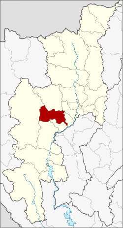
Neighboring districts are (from the south clockwise)
204:
194:
177:
169:
161:
156:
148:
143:
135:
123:
113:
32:
384:), which are further subdivided into 62 villages (
378:The district is divided into five sub-districts (
362:) was established on 1 April 1990, when the four
282:Mae Wang district occupies the western slopes of
582:(25 ง): 1349. February 13, 1990. Archived from
862:
659:
8:
616:(32 ก): 1–3. August 8, 1995. Archived from
344:is a rare holo-parasitic flower related to
869:
855:
666:
652:
644:
29:
152:601.680 km (232.310 sq mi)
558:
203:
193:
176:
155:
142:
112:
77:
62:
50:
266:peoples. In the lowlands near Ban Kad
58:Tung flags inside a temple in Mae Wang
231:
168:
160:
147:
134:
122:
7:
823:
821:
332:Topographic map of Mae Wang district
893:Chiang Mai province geography stubs
25:
888:Districts of Chiang Mai province
825:
290:on the border of Chiang Mai and
64:
52:
27:District in Chiang Mai, Thailand
1:
841:. You can help Knowledge by
909:
820:
390:). Ban Kat is a township (
685:
242:) in the central part of
224:
78:
63:
51:
42:
601:
567:
396:) which covers parts of
325:of Chiang Mai Province.
173:51.3/km (133/sq mi)
284:Thanon Thong Chai Range
837:location article is a
549:
541:
333:
547:
539:
331:
98:18.61250°N 98.77500°E
70:District location in
623:on January 26, 2009.
368:San Pa Tong district
356:The minor district (
170: • Density
835:Chiang Mai province
244:Chiang Mai province
94: /
72:Chiang Mai province
589:on April 19, 2012.
550:
542:
334:
233:[mɛ̂ːwāːŋ]
162: • Total
149: • Total
103:18.61250; 98.77500
850:
849:
818:
817:
690:Mueang Chiang Mai
529:
528:
471:Thung Ruang Thong
342:Sapria Himalayana
236:) is a district (
214:
213:
16:(Redirected from
900:
871:
864:
857:
829:
822:
668:
661:
654:
645:
625:
624:
622:
607:
597:
591:
590:
588:
573:
563:
403:
402:
292:Lamphun province
235:
230:
226:
109:
108:
106:
105:
104:
99:
95:
92:
91:
90:
87:
68:
56:
30:
21:
908:
907:
903:
902:
901:
899:
898:
897:
878:
877:
876:
875:
819:
814:
810:Galyani Vadhana
681:
672:
634:
629:
628:
620:
605:
603:
599:
598:
594:
586:
571:
569:
565:
564:
560:
555:
534:
393:thesaban tambon
376:
354:
339:
280:
228:
102:
100:
96:
93:
88:
85:
83:
81:
80:
74:
59:
47:
38:
35:
28:
23:
22:
15:
12:
11:
5:
906:
904:
896:
895:
890:
880:
879:
874:
873:
866:
859:
851:
848:
847:
830:
816:
815:
813:
812:
807:
802:
797:
792:
787:
782:
777:
772:
767:
762:
757:
752:
747:
742:
737:
732:
727:
722:
717:
712:
707:
702:
697:
692:
686:
683:
682:
673:
671:
670:
663:
656:
648:
642:
641:
633:
632:External links
630:
627:
626:
592:
557:
556:
554:
551:
533:
530:
527:
526:
524:
521:
518:
515:
510:
506:
505:
503:
500:
497:
494:
489:
485:
484:
482:
479:
476:
473:
468:
464:
463:
461:
458:
455:
452:
447:
443:
442:
440:
437:
434:
431:
426:
422:
421:
416:
413:
410:
407:
375:
374:Administration
372:
353:
350:
338:
335:
279:
276:
212:
211:
208:
202:
201:
198:
192:
191:
181:
175:
174:
171:
167:
166:
163:
159:
158:
154:
153:
150:
146:
145:
141:
140:
137:
133:
132:
127:
121:
120:
117:
111:
110:
76:
75:
69:
61:
60:
57:
49:
48:
43:
40:
39:
36:
33:
26:
24:
14:
13:
10:
9:
6:
4:
3:
2:
905:
894:
891:
889:
886:
885:
883:
872:
867:
865:
860:
858:
853:
852:
846:
844:
840:
836:
831:
828:
824:
811:
808:
806:
803:
801:
798:
796:
793:
791:
788:
786:
783:
781:
778:
776:
773:
771:
768:
766:
763:
761:
758:
756:
753:
751:
750:San Kamphaeng
748:
746:
743:
741:
738:
736:
733:
731:
728:
726:
723:
721:
718:
716:
713:
711:
708:
706:
703:
701:
698:
696:
693:
691:
688:
687:
684:
680:
676:
669:
664:
662:
657:
655:
650:
649:
646:
639:
636:
635:
631:
619:
615:
611:
610:Royal Gazette
604:
596:
593:
585:
581:
577:
576:Royal Gazette
570:
562:
559:
552:
546:
538:
531:
525:
522:
519:
516:
514:
511:
508:
507:
504:
501:
498:
495:
493:
490:
487:
486:
483:
480:
477:
474:
472:
469:
466:
465:
462:
459:
456:
453:
451:
448:
445:
444:
441:
438:
435:
432:
430:
427:
424:
423:
420:
417:
414:
411:
408:
405:
404:
401:
399:
395:
394:
389:
388:
383:
382:
373:
371:
369:
365:
361:
360:
351:
349:
347:
343:
336:
330:
326:
324:
320:
316:
312:
308:
304:
299:
295:
293:
289:
285:
277:
275:
273:
269:
265:
261:
257:
253:
249:
245:
241:
240:
234:
222:
218:
209:
207:
199:
197:
189:
185:
182:
180:
172:
164:
151:
138:
131:
128:
126:
118:
116:
107:
79:Coordinates:
73:
67:
55:
46:
41:
31:
19:
843:expanding it
832:
794:
618:the original
613:
609:
595:
584:the original
579:
575:
561:
397:
391:
385:
379:
377:
363:
357:
355:
340:
300:
296:
281:
272:Doi Inthanon
246:in northern
237:
216:
215:
790:Chai Prakan
785:Wiang Haeng
745:San Pa Tong
612:(in Thai).
578:(in Thai).
359:king amphoe
323:San Pa Tong
196:Postal code
101: /
882:Categories
705:Chiang Dao
695:Chom Thong
679:Chiang Mai
640:(archived)
638:amphoe.com
553:References
475:ทุ่งรวงทอง
412:Thai name
307:Chom Thong
288:Ping River
252:Chiang Mai
229:pronounced
157:Population
130:Chiang Mai
89:98°46′30″E
86:18°36′45″N
760:Hang Dong
715:Mae Taeng
710:Doi Saket
700:Mae Chaem
675:Districts
415:Villages
346:Rafflesia
319:Hang Dong
311:Mae Chaem
278:Geography
179:Time zone
795:Mae Wang
450:Thung Pi
258:people,
248:Thailand
217:Mae Wang
125:Province
119:Thailand
45:District
34:Mae Wang
18:Mae Wang
780:Saraphi
770:Doi Tao
755:San Sai
725:Samoeng
720:Mae Rim
532:Gallery
513:Don Pao
492:Mae Win
454:ทุ่งปี้
433:บ้านกาด
429:Ban Kat
398:tambons
364:tambons
352:History
315:Samoeng
206:Geocode
139:Ban Kat
115:Country
805:Doi Lo
800:Mae On
735:Mae Ai
517:ดอนเปา
502:10,879
496:แม่วิน
381:tambon
303:Doi Lo
239:amphoe
225:แม่วาง
165:30,871
37:แม่วาง
833:This
775:Omkoi
740:Phrao
621:(PDF)
606:(PDF)
587:(PDF)
572:(PDF)
523:7,196
481:2,650
460:4,602
439:5,544
409:Name
387:muban
337:Flora
260:Hmong
256:Karen
200:50360
184:UTC+7
839:stub
730:Fang
419:Pop.
406:No.
321:and
268:Thai
264:Akha
262:and
221:Thai
210:5022
144:Area
136:Seat
765:Hot
677:of
614:112
580:107
188:ICT
884::
608:.
574:.
520:10
509:5.
499:19
488:4.
467:3.
457:12
446:2.
436:13
425:1.
317:,
313:,
309:,
305:,
294:.
227:,
223::
870:e
863:t
856:v
845:.
667:e
660:t
653:v
478:8
219:(
190:)
186:(
20:)
Text is available under the Creative Commons Attribution-ShareAlike License. Additional terms may apply.