79:
51:
86:
58:
34:
301:, which is shaped like a keyhole, having one square end and one circular end, when viewed from above. The tumulus has a total length of 94 meters, with a posterior circular portion in two tiers and an anterior rectangular portion two tiers, and is orientated to 70 degrees northeast. Part of the mound is carved out of the ground, and only the upper tier was originally covered in
521:
361:
Grave goods included two gold earrings, 451 blue glass beads, 17 green glass beads, 28 yellow glass beads, 15 crystal beads, 6 jasper beads, 3 silver balls, several iron swords, iron hooks, saddle and horse fittings, and a comprehensive set of miniature farming tools. The tomb also contained large
341:
chronicle. The
Ushirofutago Kofun was also excavated at the same time, and was initially promoted by the government as the grave of Toyoki-irihiko no Mikoto; however, the proposed designation was lifted after only a year when a stone-lined
354:
was discovered with the
Maefutago Kofun. This created a media sensation, and an exhibition of artifacts drew crowds of visitors. Although Gunma Prefecture officially petitioned the
78:
385:
and made a number of sketches also brought back the samples of red pigment and glass beads found in the burial chamber. He published a paper in the
135:
439:
558:
389:, vol. 8, no. 3, which also included the results of chemical analysis of iron oxide and potash glass on the artifacts he brought back.
358:
for recognition of the tomb, the petition failed due to lack of evidence, and the recovered artifacts were stored at a nearby shrine.
50:
568:
498:
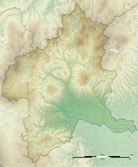
264:
in 1927. It is estimated to have been built around beginning of the 6th century AD and is part of a group of at least six
321:
were in rows on the mounds. The tumulus is surrounded by a shield-shaped double moat with a total length of 148 meters.
463:
268:
which were concentrated in the vicinity, forming the Ōmuro Kofun
Cluster. Within the Ōmuro Kofun Cluster are also the
355:
314:
382:
525:
573:
366:
pottery in various sizes and configurations. Many of these grave goods show a strong connection to the
427:
378:
371:
273:
261:
215:
563:
494:
367:
325:
269:
249:
245:
109:
253:
123:
343:
552:
329:
328:
project to find the grave of the legendary Toyoki-irihiko no Mikoto, the founder of
532:
238:
193:
459:
351:
347:
337:
333:
285:
33:
150:
137:
381:
visited the site in March 1880 on behalf of the
British government and the
520:
540:
363:
303:
309:
284:
The
Maefutago Kofun is located on a low hill at the southern foot of
244:
located in the Nishi-Ōmuro neighborhood of what is now the city of
257:
241:
170:
113:
317:
in profusion, and it is estimated that originally more than 1340
276:, which have a separate National Historic Site designations.
324:
The tumulus was first excavated in March 1878 as part of a
426:
and reconstructions of Kofun-period structures forming an
412:
The surrounding area is now maintained as Ōmuro Park
377:
The
British diplomat and amateur archaeologist, Sir
204:
199:
189:
181:
176:
166:
129:
119:
105:
307:. Cylindrical, house-shaped and other types of
415:
294:
230:
491:(国指定史跡事典) National Historic Site Encyclopedia
8:
387:Transactions of the Asiatic Society of Japan
19:
16:Kofun period burial mound in Takasaki, Japan
408:68 meter diameter x 14 meters high, 2-tier
32:
18:
484:
482:
480:
451:
440:List of Historic Sites of Japan (Gunma)
85:
57:
489:Isomura, Yukio; Sakai, Hideya (2012).
7:
14:
519:
84:
77:
56:
49:
262:National Historic Site of Japan
216:National Historic Site of Japan
370:, notably the tumulus of King
1:
533:Gunma Prefecture tourism site
399:Anterior rectangular portion
68:Show map of Gunma Prefecture
559:History of Gunma Prefecture
464:Agency for Cultural Affairs
590:
405:Posterior circular portion
416:
356:Imperial Household Agency
295:
231:
212:
43:
31:
24:
383:Asiatic Society of Japan
151:36.386167°N 139.196167°E
569:Historic Sites of Japan
93:Maefutago Kofun (Japan)
528:at Wikimedia Commons
402:65 meters wide, 2-tier
260:. It was designated a
156:36.386167; 139.196167
541:Maebashi City guide
428:archaeological park
422:with several other
346:containing a stone
147: /
21:
379:Ernest Mason Satow
372:Muryeong of Baekje
274:Ushirofutago Kofun
205:Public access
524:Media related to
332:mentioned in the
223:
222:
96:Show map of Japan
581:
545:
537:
523:
508:
507:
504:
486:
475:
474:
472:
470:
456:
421:
419:
418:
368:Korean Peninsula
326:Meiji government
300:
298:
297:
270:Nakafutago Kofun
252:in the northern
250:Gunma Prefecture
236:
234:
233:
162:
161:
159:
158:
157:
152:
148:
145:
144:
143:
140:
97:
88:
87:
81:
69:
60:
59:
53:
36:
22:
589:
588:
584:
583:
582:
580:
579:
578:
549:
548:
543:
535:
517:
512:
511:
505:
501:
488:
487:
478:
468:
466:
462:(in Japanese).
458:
457:
453:
448:
436:
413:
292:
282:
228:
226:Maefutago Kofun
219:
218:
155:
153:
149:
146:
141:
138:
136:
134:
133:
110:Maebashi, Gunma
101:
100:
99:
98:
95:
94:
91:
90:
89:
72:
71:
70:
67:
66:
65:Maefutago Kofun
63:
62:
61:
39:
38:Maefutago Kofun
27:
20:Maefutago Kofun
17:
12:
11:
5:
587:
585:
577:
576:
571:
566:
561:
551:
550:
547:
546:
538:
516:
515:External links
513:
510:
509:
499:
476:
450:
449:
447:
444:
443:
442:
435:
432:
410:
409:
406:
403:
400:
397:
394:
344:burial chamber
290:zenpō-kōen-fun
281:
278:
221:
220:
214:
213:
210:
209:
206:
202:
201:
197:
196:
191:
187:
186:
183:
179:
178:
174:
173:
168:
164:
163:
131:
127:
126:
121:
117:
116:
107:
103:
102:
92:
83:
82:
76:
75:
74:
73:
64:
55:
54:
48:
47:
46:
45:
44:
41:
40:
37:
29:
28:
25:
15:
13:
10:
9:
6:
4:
3:
2:
586:
575:
572:
570:
567:
565:
562:
560:
557:
556:
554:
544:(in Japanese)
542:
539:
536:(in Japanese)
534:
531:
530:
529:
527:
522:
514:
506:(in Japanese)
502:
496:
492:
485:
483:
481:
477:
465:
461:
455:
452:
445:
441:
438:
437:
433:
431:
429:
425:
407:
404:
401:
398:
395:
392:
391:
390:
388:
384:
380:
375:
373:
369:
365:
359:
357:
353:
350:and numerous
349:
345:
340:
339:
335:
331:
330:Keno Province
327:
322:
320:
316:
312:
311:
306:
305:
291:
287:
279:
277:
275:
271:
267:
263:
259:
255:
251:
247:
243:
240:
227:
217:
211:
207:
203:
198:
195:
192:
188:
184:
180:
175:
172:
169:
165:
160:
142:139°11′46.2″E
132:
128:
125:
122:
118:
115:
111:
108:
104:
80:
52:
42:
35:
30:
23:
574:Zenpokoenfun
518:
490:
467:. Retrieved
454:
423:
411:
393:Total length
386:
376:
362:quantity of
360:
336:
323:
318:
308:
302:
289:
283:
265:
254:Kantō region
242:burial mound
239:Kofun period
225:
224:
194:Kofun period
139:36°23′10.2″N
124:Kantō region
352:grave goods
348:sarcophagus
338:Nihon Shoki
334:Nara period
286:Mount Akagi
185:6th century
154: /
130:Coordinates
553:Categories
526:Omuro Park
500:4311750404
469:August 20,
446:References
313:were also
288:. It is a
208:Yes (Park)
200:Site notes
396:94 meters
315:excavated
564:Maebashi
434:See also
364:Sue ware
304:fukiishi
280:Overview
272:and the
246:Takasaki
106:Location
493:. 学生社.
460:"大鶴巻古墳"
190:Periods
182:Founded
177:History
497:
417:大室公園¥¥
319:haniwa
310:haniwa
120:Region
424:kofun
296:前方後円墳
266:kofun
258:Japan
237:is a
232:前二子古墳
171:kofun
114:Japan
26:前二子古墳
495:ISBN
471:2020
167:Type
256:of
555::
479:^
430:.
374:.
248:,
112:,
503:.
473:.
420:)
414:(
299:)
293:(
235:)
229:(
Text is available under the Creative Commons Attribution-ShareAlike License. Additional terms may apply.