91:
51:
in its north, in the South-East of
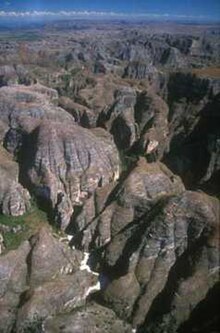
Madagascar. It covers an area of approximately 4000 km. It extends north-northeast–south-southwest for approximately 150 km, and is up to 50 km wide. The massif reaches up to 1000 meters elevation. It is deeply dissected by sinuous canyons. It forms
326:
Fromont C, Blanco J, Culas C, Pannier E, Razafindrakoto M, et al. (2022) Towards an inclusive nature conservation initiative: Preliminary assessment of stakeholders’ representations about the Makay region, Madagascar. PLOS ONE 17(8): e0272223.
339:
Dolch, Rainer & Ratsisetraina, Rita & Markolf, Matthias & Ratolojanahary, Tiana & Rakotonirina, Hanitriniaina & Louis, Edward & Wendenbaum, Evrard. (2011). Assessment of lemur diversity in the Makay massif.
20:
231:
The deeply dissected topography makes the massif mostly impassable. The massif is largely uninhabited, and residents mostly live in villages of 500 or fewer people at the edges of the massif. Herding
122:
adapted to the thin soils and dry conditions, and some patches of dry forest. In contrast the canyons are home to lush forests, including stands of
377:
362:
244:
164:
367:
53:
235:
cattle is an important occupation for inhabitants, and they also rely on forest resources from the massif.
198:
180:
291:
Aldegheri, M. (1972). Rivers and
Streams on Madagascar. In: Battistini, R., Richard-Vindard, G. (eds)
156:
44:
84:
90:
208:
188:
148:
134:
102:
mudstones and sandstones, also known as the Makay
Formation. The formation include fossils of
68:
307:
Brenon, P. (1972). The
Geology of Madagascar. In: Battistini, R., Richard-Vindard, G. (eds)
172:
75:, including the Makay River, drain the southeastern and southern slopes of the massif. The
372:
140:
76:
216:
80:
356:
119:
72:
57:
115:
64:
48:
328:
312:
296:
32:
114:
The ridges and plateaus generally have sparse vegetation, with species of
128:
103:
99:
263:
123:
67:
rises from the northeastern massif and flows northward to join the
89:
19:
18:
279:
232:
83:
rise from the western slope, and empty westwards into the
311:. Monographiae Biologicae, vol 21. Springer, Dordrecht.
295:. Monographiae Biologicae, vol 21. Springer, Dordrecht.
63:
Several rivers have their springs in the massif. The
94:
Map of the rivers originating from the Makay Massif
247:) is unpaved and can only been taken by 4x4 cars.
43:The Makay Massif is situated in the district of
8:
329:https://doi.org/10.1371/journal.pone.0272223
313:https://doi.org/10.1007/978-94-015-7159-3_2
297:https://doi.org/10.1007/978-94-015-7159-3_8
280:Le massif du Makay – Aire Protégée du Makay
223:), Madagascar's largest native carnivore.
322:
320:
275:
273:
271:
256:
309:Biogeography and Ecology in Madagascar
293:Biogeography and Ecology in Madagascar
7:
98:The massif's bedrock is principally
14:
31:is a mountain range in western
1:
52:part of the boundary between
282:. Accessed 22 November 2022.
165:Coquerel's giant mouse lemur
16:Mountain range in Madagascar
378:Madagascar subhumid forests
394:
215:). It is also home to the
147:Native lemurs include the
56:on the south and east and
23:Makay Massif from the air
363:Mountains of Madagascar
60:on the west and north.
54:Atsimo-Andrefana Region
243:The road to Beroroha (
181:fat-tailed dwarf lemur
95:
24:
161:Propithecus verreauxi
93:
71:. Tributaries of the
39:Geography and geology
22:
344:. Volume 16. 48-53.
185:Cheirogaleus medius
221:Cryptoprocta ferox
177:Microcebus murinus
96:
85:Mozambique Channel
25:
209:ring-tailed lemur
157:Verreaux's sifaka
153:Eulemur rufifrons
149:red-fronted lemur
135:Ravenea rivularis
69:Tsiribihina River
47:in the south and
385:
368:Atsimo-Andrefana
345:
337:
331:
324:
315:
305:
299:
289:
283:
277:
266:
261:
245:National Road 15
173:gray mouse lemur
132:, and the palms
393:
392:
388:
387:
386:
384:
383:
382:
353:
352:
349:
348:
338:
334:
325:
318:
306:
302:
290:
286:
278:
269:
262:
258:
253:
241:
229:
169:Mirza coquereli
141:Ravenea lakatra
112:
110:Flora and fauna
41:
17:
12:
11:
5:
391:
389:
381:
380:
375:
370:
365:
355:
354:
347:
346:
332:
316:
300:
284:
267:
255:
254:
252:
249:
240:
237:
228:
225:
111:
108:
40:
37:
15:
13:
10:
9:
6:
4:
3:
2:
390:
379:
376:
374:
371:
369:
366:
364:
361:
360:
358:
351:
343:
336:
333:
330:
323:
321:
317:
314:
310:
304:
301:
298:
294:
288:
285:
281:
276:
274:
272:
268:
265:
260:
257:
250:
248:
246:
238:
236:
234:
226:
224:
222:
218:
214:
210:
206:
205:
201:
196:
195:
191:
186:
182:
178:
174:
170:
166:
162:
158:
154:
150:
145:
143:
142:
137:
136:
131:
130:
125:
121:
120:Euphorbiaceae
117:
109:
107:
105:
101:
92:
88:
86:
82:
78:
74:
73:Mangoky River
70:
66:
61:
59:
58:Menabe Region
55:
50:
46:
38:
36:
34:
30:
21:
350:
341:
335:
308:
303:
292:
287:
259:
242:
230:
220:
212:
204:ruficaudatus
203:
199:
193:
189:
184:
176:
168:
160:
152:
146:
139:
133:
127:
116:Didiereaceae
113:
97:
65:Sakeny River
62:
42:
29:Makay Massif
28:
26:
213:Lemur catta
49:Malaimbandy
357:Categories
342:Lemur news
251:References
194:pallescens
33:Madagascar
200:Lepilemur
77:Morondava
264:Beroroha
129:Pandanus
106:period.
104:Triassic
100:Isalo II
81:Maharivo
45:Beroroha
373:Menabe
239:Access
227:People
207:, and
190:Phaner
124:bamboo
217:fossa
233:zebu
202:cf.
192:cf.
138:and
118:and
79:and
27:The
187:),
179:),
171:),
163:),
155:),
359::
319:^
270:^
197:,
144:.
126:,
87:.
35:.
219:(
211:(
183:(
175:(
167:(
159:(
151:(
Text is available under the Creative Commons Attribution-ShareAlike License. Additional terms may apply.