237:
42:
29:
293:
49:
228:
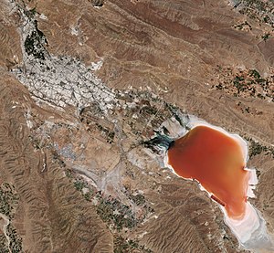
Rudkhane-ye-Khoshk, a seasonal river flowing through the city of Shiraz, brings most of the flood water to the lake bed during intensive precipitation events. The lake water typically evaporates by the end of summer and exposes the white lake bed. By mid-summer and due to high evaporation rates and
86:
334:
368:
358:
183:
41:
327:
363:
320:
353:
240:
236:
128:
304:
300:
206:
253:
140:
28:
347:
258:
118:
276:
101:
88:
214:
292:
229:
salt concentrations, the lake water turns pinkish red as a result of the
230:
129:
222:
71:
235:
218:
308:
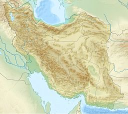
221:, 27.0 km (16.8 mi) southeast of the city of
225:. The lake salt is rich in potassium and other salts.
192:
182:
178:
170:
162:
154:
150:
139:
127:
117:
78:
66:
21:
79:
328:
8:
16:Seasonal salt lake in south of Shiraz urban
335:
321:
18:
269:
135:Dry river, Soltanabad river (seasonal)
48:
7:
289:
287:
210:
307:. You can help Knowledge (XXG) by
14:
243:photo of Shiraz and Maharloo Lake
158:600 km (230 sq mi)
369:Sarvestan County geography stubs
291:
47:
40:
27:
169:
161:
153:
1:
65:
174:1,500 m (4,900 ft)
166:ca. 100 m (330 ft)
385:
359:Landforms of Fars province
286:
277:FARS Geography and History
35:
26:
303:location article is a
244:
241:European Space Agency
239:
364:Saline lakes of Asia
217:in the highlands of
98: /
245:
123:Seasonal salt lake
316:
315:
233:within the lake.
200:
199:
171:Surface elevation
102:29.467°N 52.800°E
376:
337:
330:
323:
301:Sarvestan County
295:
288:
279:
274:
213:) is a seasonal
212:
131:
113:
112:
110:
109:
108:
103:
99:
96:
95:
94:
91:
81:
51:
50:
44:
31:
19:
384:
383:
379:
378:
377:
375:
374:
373:
344:
343:
342:
341:
284:
282:
275:
271:
267:
250:
143: countries
130:Primary inflows
106:
104:
100:
97:
92:
89:
87:
85:
84:
62:
61:
60:
59:
58:
57:
56:
52:
17:
12:
11:
5:
382:
380:
372:
371:
366:
361:
356:
346:
345:
340:
339:
332:
325:
317:
314:
313:
296:
281:
280:
268:
266:
263:
262:
261:
256:
254:Dasht-e Arzhan
249:
246:
198:
197:
194:
190:
189:
186:
180:
179:
176:
175:
172:
168:
167:
164:
160:
159:
156:
152:
151:
148:
147:
144:
137:
136:
133:
125:
124:
121:
115:
114:
107:29.467; 52.800
82:
76:
75:
68:
64:
63:
54:
53:
46:
45:
39:
38:
37:
36:
33:
32:
24:
23:
15:
13:
10:
9:
6:
4:
3:
2:
381:
370:
367:
365:
362:
360:
357:
355:
354:Lakes of Iran
352:
351:
349:
338:
333:
331:
326:
324:
319:
318:
312:
310:
306:
302:
297:
294:
290:
285:
278:
273:
270:
264:
260:
259:Lake Parishan
257:
255:
252:
251:
247:
242:
238:
234:
232:
226:
224:
220:
216:
211:دریاچه مهارلو
208:
204:
203:Maharloo Lake
195:
191:
187:
185:
181:
177:
173:
165:
157:
149:
145:
142:
138:
134:
132:
126:
122:
120:
116:
111:
83:
77:
73:
69:
55:Maharloo Lake
43:
34:
30:
25:
22:Maharloo Lake
20:
309:expanding it
298:
283:
272:
227:
202:
201:
155:Surface area
193:Settlements
105: /
80:Coordinates
348:Categories
265:References
163:Max. depth
215:salt lake
70:south of
248:See also
231:red tide
67:Location
207:Persian
184:Islands
93:52°48′E
90:29°28′N
223:Shiraz
196:Shiraz
72:Shiraz
299:This
141:Basin
74:urban
305:stub
219:Iran
188:none
146:Iran
119:Type
350::
209::
336:e
329:t
322:v
311:.
205:(
Text is available under the Creative Commons Attribution-ShareAlike License. Additional terms may apply.