282:) began developing around Hubbard and Weed's sawmill on the Black River. The mill burned in 1889, but by that time Ramsay was home to the company headquarters of and workers from the nearby Castile Mining Company. At the turn of the century, Ramsay's Main Street was carried over the Black River by an older truss bridge; by the end of the 1910s, the bridge was deteriorating and was a bottleneck for vehicular traffic. The Gogebic County Road Commission asked the state to help fund a replacement bridge, and in 1922 engineers from the Michigan State Highway Department designed a bridge to span the Black river, designating it Bridge File No. 270103. A contract for $ 19,455.14 was awarded to Paul N. Massie of nearby
315:
curb," as stated in their
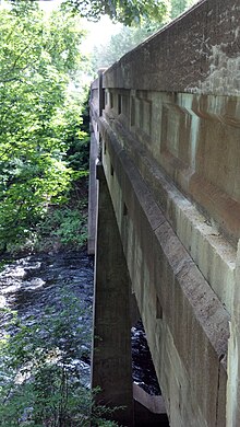
Seventh Biennial Report. The Highway Department used this design until about 1930, and in that span designed and built perhaps hundreds of them through the state. Most of this type of bridge were single-span structures; the triple-span design and tapered piers of the Main Street–Black River Bridge mark it as a noteworthy example of the design's potential. The bridge is visually striking when views from the river, and is historically important for enabling local vehicular transportation. Other than minor concrete spalling, the bridge is essentially unaltered and remains in good condition.
271:
263:
48:
65:
934:
90:
298:, with a main span length of 50 feet (15 m) and a complete structure length of 130 feet (40 m). The structure is 27 feet 2 inches (8.28 m) wide, of which 22 feet (6.7 m) is the roadway. Three concrete girders carry the roadway: a central 50-foot (15 m) girder, and two 40-foot (12 m) girders on each end. The girders sit on tapered concrete piers. Panels are recessed in the girder walls, which are capped with heavy concrete
327:
339:
945:
351:
97:
72:
314:
design used for the Main Street–Black River Bridge was a well-tested standard design. The
Michigan State Highway Department had first delineated this type of structure in 1913-14, and used them for "spans from thirty to fifty feet in both the eighteen and twenty-foot clear roadway from curb to
823:
918:
854:
838:
969:
828:
984:
360:
913:
859:
500:
880:
782:
813:
747:
712:
787:
692:
652:
477:
979:
752:
742:
737:
717:
833:
667:
582:
702:
697:
572:
792:
757:
662:
637:
777:
727:
707:
682:
672:
657:
647:
632:
612:
587:
577:
567:
797:
772:
677:
617:
597:
592:
562:
552:
732:
687:
627:
602:
557:
864:
762:
642:
607:
818:
767:
722:
622:
530:
515:
989:
470:
546:
130:
286:, who completed construction in 1923. Since that time, the Main Street–Black River Bridge has been essentially unaltered, and continues to carry vehicular traffic.
994:
948:
463:
89:
938:
64:
999:
510:
486:
388:
251:
34:
974:
901:
243:
204:
418:
247:
118:
906:
885:
270:
262:
47:
279:
520:
525:
505:
393:
311:
295:
197:
343:
283:
209:
455:
331:
355:
326:
338:
222:
963:
421:. Michigan State Housing Development Authority: Historic Sites Online. Archived from
919:
University and college buildings listed on the
National Register of Historic Places
448:
422:
302:. Bronze plates stating "State Reward Bridge" are mounted on each sidewall.
145:
132:
361:
National
Register of Historic Places listings in Gogebic County, Michigan
299:
914:
List of jails and prisons on the
National Register of Historic Places
970:
Road bridges on the
National Register of Historic Places in Michigan
269:
261:
383:
985:
National
Register of Historic Places in Gogebic County, Michigan
459:
96:
71:
980:
Buildings and structures in
Gogebic County, Michigan
894:
873:
847:
806:
539:
516:
History of the
National Register of Historic Places
493:
228:
215:
203:
193:
185:
177:
169:
161:
124:
113:
547:List of U.S. National Historic Landmarks by state
294:The Main Street–Black River Bridge is a concrete
939:National Register of Historic Places portal
471:
8:
242:is a bridge located on Main Street over the
478:
464:
456:
46:
990:Plate girder bridges in the United States
487:U.S. National Register of Historic Places
35:U.S. National Register of Historic Places
413:
411:
409:
407:
405:
403:
372:
278:In 1884, the village of Ramsay (now an
384:"National Register Information System"
378:
376:
18:
995:Concrete bridges in the United States
7:
389:National Register of Historic Places
252:National Register of Historic Places
902:National Historic Preservation Act
14:
944:
943:
932:
419:"Main Street/Black River Bridge"
349:
337:
325:
95:
88:
70:
63:
1000:1923 establishments in Michigan
210:Highway Bridges of Michigan MPS
855:Federated States of Micronesia
501:Architectural style categories
240:Main Street–Black River Bridge
217:
27:Main Street–Black River Bridge
1:
104:Show map of the United States
250:, USA. It was listed on the
189:Michigan State Highway Dept.
16:United States historic place
248:Bessemer Township, Michigan
119:Bessemer Township, Michigan
1016:
907:Historic Preservation Fund
886:American Legation, Morocco
975:Bridges completed in 1923
927:
848:Lists by associated state
216:NRHP reference
57:
45:
41:
32:
25:
21:
829:Northern Mariana Islands
280:unincorporated community
194:Architectural style
117:Main St. over Black R.,
824:Minor Outlying Islands
807:Lists by insular areas
521:Keeper of the Register
451:. HistoricBridges.org.
344:Engineering portal
310:By 1923, the concrete
275:
267:
526:National Park Service
506:Contributing property
394:National Park Service
312:through girder bridge
296:through girder bridge
273:
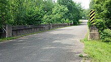
265:
198:Through girder bridge
146:46.47361°N 90.00139°W
881:District of Columbia
425:on December 24, 2012
332:Transport portal
79:Show map of Michigan
356:Michigan portal
151:46.47361; -90.00139
142: /
276:
268:
165:less than one acre
957:
956:
511:Historic district
236:
235:
1007:
947:
946:
937:
936:
935:
860:Marshall Islands
480:
473:
466:
457:
452:
435:
434:
432:
430:
415:
398:
397:
380:
354:
353:
352:
342:
341:
330:
329:
232:December 9, 1999
219:
157:
156:
154:
153:
152:
147:
143:
140:
139:
138:
135:
105:
99:
98:
92:
80:
74:
73:
67:
50:
19:
1015:
1014:
1010:
1009:
1008:
1006:
1005:
1004:
960:
959:
958:
953:
933:
931:
923:
890:
869:
843:
802:
535:
489:
484:
449:"Ramsay Bridge"
447:
444:
439:
438:
428:
426:
417:
416:
401:
396:. July 9, 2010.
382:
381:
374:
369:
350:
348:
336:
324:
321:
308:
292:
260:
150:
148:
144:
141:
136:
133:
131:
129:
128:
109:
108:
107:
106:
103:
102:
101:
100:
83:
82:
81:
78:
77:
76:
75:
53:
37:
28:
17:
12:
11:
5:
1013:
1011:
1003:
1002:
997:
992:
987:
982:
977:
972:
962:
961:
955:
954:
952:
951:
941:
928:
925:
924:
922:
921:
916:
911:
910:
909:
898:
896:
892:
891:
889:
888:
883:
877:
875:
871:
870:
868:
867:
862:
857:
851:
849:
845:
844:
842:
841:
839:Virgin Islands
836:
831:
826:
821:
816:
814:American Samoa
810:
808:
804:
803:
801:
800:
795:
790:
785:
780:
775:
770:
765:
760:
755:
750:
748:South Carolina
745:
740:
735:
730:
725:
720:
715:
713:North Carolina
710:
705:
700:
695:
690:
685:
680:
675:
670:
665:
660:
655:
650:
645:
640:
635:
630:
625:
620:
615:
610:
605:
600:
595:
590:
585:
580:
575:
570:
565:
560:
555:
550:
543:
541:
540:Lists by state
537:
536:
534:
533:
531:Property types
528:
523:
518:
513:
508:
503:
497:
495:
491:
490:
485:
483:
482:
475:
468:
460:
454:
453:
443:
442:External links
440:
437:
436:
399:
371:
370:
368:
365:
364:
363:
358:
346:
334:
320:
317:
307:
304:
291:
288:
259:
256:
234:
233:
230:
226:
225:
220:
213:
212:
207:
201:
200:
195:
191:
190:
187:
183:
182:
181:Paul N. Massie
179:
175:
174:
171:
167:
166:
163:
159:
158:
126:
122:
121:
115:
111:
110:
94:
93:
87:
86:
85:
84:
69:
68:
62:
61:
60:
59:
58:
55:
54:
52:Bridge in 2013
51:
43:
42:
39:
38:
33:
30:
29:
26:
23:
22:
15:
13:
10:
9:
6:
4:
3:
2:
1012:
1001:
998:
996:
993:
991:
988:
986:
983:
981:
978:
976:
973:
971:
968:
967:
965:
950:
942:
940:
930:
929:
926:
920:
917:
915:
912:
908:
905:
904:
903:
900:
899:
897:
893:
887:
884:
882:
879:
878:
876:
872:
866:
863:
861:
858:
856:
853:
852:
850:
846:
840:
837:
835:
832:
830:
827:
825:
822:
820:
817:
815:
812:
811:
809:
805:
799:
796:
794:
791:
789:
788:West Virginia
786:
784:
781:
779:
776:
774:
771:
769:
766:
764:
761:
759:
756:
754:
751:
749:
746:
744:
741:
739:
736:
734:
731:
729:
726:
724:
721:
719:
716:
714:
711:
709:
706:
704:
701:
699:
696:
694:
693:New Hampshire
691:
689:
686:
684:
681:
679:
676:
674:
671:
669:
666:
664:
661:
659:
656:
654:
653:Massachusetts
651:
649:
646:
644:
641:
639:
636:
634:
631:
629:
626:
624:
621:
619:
616:
614:
611:
609:
606:
604:
601:
599:
596:
594:
591:
589:
586:
584:
581:
579:
576:
574:
571:
569:
566:
564:
561:
559:
556:
554:
551:
548:
545:
544:
542:
538:
532:
529:
527:
524:
522:
519:
517:
514:
512:
509:
507:
504:
502:
499:
498:
496:
492:
488:
481:
476:
474:
469:
467:
462:
461:
458:
450:
446:
445:
441:
424:
420:
414:
412:
410:
408:
406:
404:
400:
395:
391:
390:
385:
379:
377:
373:
366:
362:
359:
357:
347:
345:
340:
335:
333:
328:
323:
322:
318:
316:
313:
305:
303:
301:
297:
289:
287:
285:
281:
272:
264:
257:
255:
253:
249:
245:
241:
231:
229:Added to NRHP
227:
224:
221:
214:
211:
208:
206:
202:
199:
196:
192:
188:
184:
180:
176:
172:
168:
164:
160:
155:
127:
123:
120:
116:
112:
91:
66:
56:
49:
44:
40:
36:
31:
24:
20:
753:South Dakota
743:Rhode Island
738:Pennsylvania
718:North Dakota
429:December 22,
427:. Retrieved
423:the original
387:
309:
306:Significance
293:
277:
239:
237:
874:Other areas
834:Puerto Rico
668:Mississippi
583:Connecticut
290:Description
274:Bridge deck
246:in Ramsay,
244:Black River
149: /
125:Coordinates
964:Categories
783:Washington
703:New Mexico
698:New Jersey
573:California
367:References
134:46°28′25″N
793:Wisconsin
758:Tennessee
663:Minnesota
638:Louisiana
254:in 1999.
186:Architect
949:Category
778:Virginia
728:Oklahoma
708:New York
683:Nebraska
673:Missouri
658:Michigan
648:Maryland
633:Kentucky
613:Illinois
588:Delaware
578:Colorado
568:Arkansas
319:See also
284:Bessemer
223:99001514
178:Built by
137:90°0′5″W
114:Location
895:Related
798:Wyoming
773:Vermont
678:Montana
618:Indiana
598:Georgia
593:Florida
563:Arizona
553:Alabama
300:corbels
258:History
733:Oregon
688:Nevada
628:Kansas
603:Hawaii
558:Alaska
494:Topics
865:Palau
763:Texas
643:Maine
608:Idaho
170:Built
819:Guam
768:Utah
723:Ohio
623:Iowa
431:2011
266:Side
238:The
173:1923
162:Area
218:No.
205:MPS
966::
402:^
392:.
386:.
375:^
549::
479:e
472:t
465:v
433:.
Text is available under the Creative Commons Attribution-ShareAlike License. Additional terms may apply.