343:
33:
366:, where it enters the Vltava River at the elevation of 384 m (1,260 ft). The river is 96.0 km (59.7 mi) long, of which 89.3 km (55.5 mi) is in the Czech Republic (including the 22 km (14 mi) stretch that forms the Austrian-Czech border). Its
499:
with an area of 201 ha (500 acres). It serves as a drinking water reservoir for České Budějovice and the surrounding area. There are 179 bodies of water larger than 1 ha in the basin area.
342:
468:
625:
640:
476:
635:
508:
605:
620:
630:
334:
The name is derived from the personal name Malch. The land through which the river flows once belonged to someone of that name.
370:
has an area of 979.1 km (378.0 sq mi), of which 869.2 km (335.6 sq mi) is in the Czech
Republic.
529:
178:
72:
443:, then turns north into the hinterland of the Czech Republic. The river then flows through the municipal territories of
460:
645:
444:
77:
428:
363:
38:
650:
436:
323:
85:
496:
362:
at the elevation of 985 m (3,232 ft), on the slope of the
Viehberg mountain, and flows to
359:
127:
601:
291:
367:
303:
57:
556:
614:
440:
319:
91:
464:
149:
577:
456:
193:
180:
311:
278:
533:
484:
495:
The largest body of water on the Malše and in its whole basin area is the
472:
452:
448:
347:
307:
62:
315:
270:
164:
480:
432:
355:
341:
299:
123:
32:
274:
427:
The most notable settlement on the river is the city of
431:. In Austria, the river flows past the territories of
253:
7.26 m/s (256 cu ft/s) near the estuary
557:"Základní charakteristiky toku Malše a jeho povodí"
266:
261:
247:
239:
227:
219:
209:
170:
158:
148:
134:
117:
109:
100:
71:
50:
45:
21:
559:(in Czech). T. G. Masaryk Water Research Institute
604:– Flood Warning and Forecasting Service of the
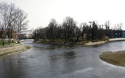
37:Confluence of the Malše and Vltava rivers in
8:
373:The longest tributaries of the Malše are:
326:. It is 96.0 km (59.7 mi) long.
578:"Řeka Malše – pravostranný přítok Vltavy"
551:
549:
354:The Malše originates in the territory of
375:
520:
18:
231:979.1 km (378.0 sq mi)
7:
509:List of rivers of the Czech Republic
626:Rivers of the South Bohemian Region
606:Czech Hydrometeorological Institute
14:
31:
16:River in Czech Republic, Austria
636:International rivers of Europe
172: • coordinates
1:
641:Austria–Czech Republic border
530:"Řeky si pojmenovali nejdřív"
101:Physical characteristics
602:River flow at Roudné station
528:Loucká, Pavla (1997-09-05).
211: • elevation
136: • elevation
223:96.0 km (59.7 mi)
160: • location
119: • location
667:
249: • average
215:384 m (1,260 ft)
140:985 m (3,232 ft)
621:Tributaries of the Vltava
257:
235:
144:
105:
30:
580:(in Czech). CzechTourism
318:River. It flows through
631:Rivers of Upper Austria
487:and České Budějovice.
437:Windhaag bei Freistadt
351:
295:
345:
324:South Bohemian Region
194:48.97278°N 14.47000°E
461:Svatý Jan nad Malší
262:Basin features
190: /
352:
199:48.97278; 14.47000
646:Rivers of Austria
420:
419:
360:Gratzen Mountains
284:
283:
128:Gratzen Mountains
658:
589:
588:
586:
585:
574:
568:
567:
565:
564:
553:
544:
543:
541:
540:
525:
429:České Budějovice
376:
364:České Budějovice
250:
205:
204:
202:
201:
200:
195:
191:
188:
187:
186:
183:
137:
120:
39:České Budějovice
35:
19:
666:
665:
661:
660:
659:
657:
656:
655:
611:
610:
598:
593:
592:
583:
581:
576:
575:
571:
562:
560:
555:
554:
547:
538:
536:
527:
526:
522:
517:
505:
497:Římov Reservoir
493:
491:Bodies of water
425:
340:
332:
248:
212:
198:
196:
192:
189:
184:
181:
179:
177:
176:
173:
161:
135:
118:
96:
90:
76:
67:
41:
26:
23:
17:
12:
11:
5:
664:
662:
654:
653:
648:
643:
638:
633:
628:
623:
613:
612:
609:
608:
597:
596:External links
594:
591:
590:
569:
545:
519:
518:
516:
513:
512:
511:
504:
501:
492:
489:
445:Dolní Dvořiště
424:
421:
418:
417:
414:
411:
408:
404:
403:
400:
397:
394:
390:
389:
386:
383:
380:
368:drainage basin
339:
338:Characteristic
336:
331:
328:
304:Czech Republic
282:
281:
268:
264:
263:
259:
258:
255:
254:
251:
245:
244:
241:
237:
236:
233:
232:
229:
225:
224:
221:
217:
216:
213:
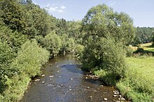
210:
207:
206:
174:
171:
168:
167:
162:
159:
156:
155:
152:
146:
145:
142:
141:
138:
132:
131:
121:
115:
114:
111:
107:
106:
103:
102:
98:
97:
95:
94:
88:
86:South Bohemian
82:
80:
69:
68:
66:
65:
60:
58:Czech Republic
54:
52:
48:
47:
43:
42:
36:
28:
27:
24:
15:
13:
10:
9:
6:
4:
3:
2:
663:
652:
651:Border rivers
649:
647:
644:
642:
639:
637:
634:
632:
629:
627:
624:
622:
619:
618:
616:
607:
603:
600:
599:
595:
579:
573:
570:
558:
552:
550:
546:
535:
531:
524:
521:
514:
510:
507:
506:
502:
500:
498:
490:
488:
486:
482:
478:
474:
470:
466:
462:
458:
454:
450:
446:
442:
441:Leopoldschlag
438:
434:
430:
422:
415:
412:
409:
406:
405:
401:
398:
395:
392:
391:
387:
384:
381:
378:
377:
374:
371:
369:
365:
361:
357:
349:
346:The Malše at
344:
337:
335:
329:
327:
325:
321:
320:Upper Austria
317:
313:
309:
305:
301:
297:
293:
289:
280:
276:
272:
269:
265:
260:
256:
252:
246:
242:
238:
234:
230:
226:
222:
218:
214:
208:
203:
175:
169:
166:
163:
157:
153:
151:
147:
143:
139:
133:
129:
125:
122:
116:
112:
108:
104:
99:
93:
92:Upper Austria
89:
87:
84:
83:
81:
79:
74:
70:
64:
61:
59:
56:
55:
53:
49:
44:
40:
34:
29:
20:
582:. Retrieved
572:
561:. Retrieved
537:. Retrieved
532:(in Czech).
523:
494:
426:
372:
353:
333:
287:
285:
423:Settlements
382:Length (km)
267:Progression
197: /
615:Categories
584:2023-10-20
563:2023-10-20
539:2023-10-20
515:References
310:, a right
228:Basin size
185:14°28′12″E
182:48°58′22″N
393:Stropnice
379:Tributary
330:Etymology
312:tributary
279:North Sea
240:Discharge
130:, Austria
51:Countries
503:See also
473:Doudleby
385:River km
350:-Pořešín
322:and the
46:Location
465:Velešín
457:Soběnov
453:Kaplice
449:Bujanov
358:in the
348:Kaplice
314:of the
308:Austria
302:in the
298:) is a
296:Maltsch
73:Regions
63:Austria
25:Maltsch
534:Vesmír
485:Roudné
416:right
402:right
316:Vltava
292:German
271:Vltava
243:
220:Length
165:Vltava
154:
113:
110:Source
78:States
481:Vidov
469:Římov
433:Sandl
407:Černá
388:Side
356:Sandl
300:river
288:Malše
150:Mouth
124:Sandl
22:Malše
477:Plav
439:and
413:44.7
410:29.3
399:16.6
396:58.4
306:and
286:The
275:Elbe
617::
548:^
483:,
479:,
475:,
471:,
467:,
463:,
459:,
455:,
451:,
447:,
435:,
294::
277:→
273:→
126:,
587:.
566:.
542:.
290:(
75:/
Text is available under the Creative Commons Attribution-ShareAlike License. Additional terms may apply.