24:
32:
309:, 350 miles (560 km) to the north. Other Paiute and Bannock were scattered about Eastern Oregon, northeastern California and northern Nevada, working for settlers or engaged in subsistence hunting and gathering. More than a year after the war, most had not moved back onto the reservation, although the U.S. government had urged them to do so. Still others were interned at
293:, one of the principal Paiute war leaders, and a number of his followers. After that point, having lost their leader, scattered bands of Paiute took refuge in the mountains, and many of the Bannock tried to return to Idaho. Ultimately, most Paiute surrendered. Together with Bannock prisoners, they were initially interned at the Malheur Indian Reservation.
87:
for the
Northern Paiute. It was intended for "all the roving and straggling bands in Eastern and Southeastern Oregon, which can be induced to settle there." The goal was to reduce conflict between the Paiute, who were struggling to find enough food for survival, and the settlers, whose farms and
277:
to the north of the Harney Basin. They raided isolated ranches as they fled northward, killing some settlers, and taking horses and cattle. In engagements with the Army, both Paiute and soldiers were killed, but casualties were few, given that hundreds of soldiers were operating on each side.
316:
Ranchers and settlers had started to graze their herds on the best meadowlands of the
Malheur Indian Reservation, and the U.S. Army had been reluctant to remove the trespassers. In his annual report in August 1879, Agent W. V. Rinehart, who had fought in the
237:
country of
Eastern Oregon, the ranchers considered the streams and pastures along those trails as highly valuable for sustaining the cattle on the drives. But, the cattle consumed water and were pastured in lands that were reserved for the Paiute.
449:
128:
and son
Natchez Winnemucca went to Malheur Indian Reservation. In 1865 they had lost 29 of 30 people in a band in a raid by Nevada Volunteer cavalry, including the chief's two wives, one of whom was the mother of Sarah and Natchez.
325:
and held negative views of the
Natives, opined that the reservation should be discontinued, in part because the support for all agencies in Oregon was spread too thin to be effective. In October of that year, the
225:, and southern Grant County. With the completion of major portions of the transcontinental railroad in 1868, cattle ranchers in the former Nez Perce lands had begun to drive herds along those trails to
458:
645:
285:
on the
Columbia River, the Umatilla saw that the Paiute and Bannock were not going to prevail against the U.S. Army, which outnumbered the Native Americans. The
539:
655:
660:
478:
665:
254:
to the south of the Harney Basin. The mountain is a large block-fault formation, and its eastern escarpment rises almost straight up from the
369:
611:
301:
In
November 1878, General Howard received orders to move about 543 Paiute and Bannock prisoners from the Malheur Indian Reservation to the
59:
of 1878, under pressure from
European-American settlers who wanted the land. This negative recommendation against continuing by its agent
455:
359:
206:: the "wada-seed-eaters".) Settlers along Willow Creek Valley on the eastern edge of the reservation also protested the boundaries.
571:
289:
allied with the Army. Under the guise of negotiation, some warriors entered an encampment of Paiute and
Bannock, where they killed
339:
76:
650:
327:
518:
583:
148:. It comprised approximately 2,285 square miles (5,920 km) or 1,462,400 acres (5,918 km). At that time,
615:
536:
302:
64:
27:
Harney Basin looking from Wright's Point north towards Burns, Oregon, and to the Blue
Mountains in the distance.
640:
226:
141:
137:
17:
196:
open for settlement. This was a blow to the Paiute, because that was an area where the tribe collected wada (
306:
274:
23:
635:
88:
ranches encroached on their territory. About 800 Northern Paiute were living in settlements and at Forts
282:
234:
210:
55:
and northern Nevada from 1872 to 1879. The federal government discontinued the reservation after the
121:
60:
310:
266:
250:
in May 1878 in Idaho led the Paiute to abandon the Malheur Indian Reservation and take refuge on
230:
44:
396:
338:
Today a small group of Paiute lives on a small allotment of 760 acres (3.1 km), called the
16:
This article is about the Oregon Indian reservation. For other uses of the word "Malheur", see
318:
173:
559:
408:
286:
273:
began moving toward their positions, the united Paiute and Bannock decided to move into the
270:
189:
125:
80:
67:, as well as the reluctance of the Bannock and Paiute to return to the lands after the war.
543:
462:
262:
251:
218:
97:
48:
202:) seeds, which they gathered as food. (The Paiute around Malheur Lake were known as the
31:
620:
153:
133:
109:
84:
629:
347:
343:
290:
255:
181:
161:
145:
117:
364:
322:
214:
193:
188:
Basin on the southwest edge of the reservation. In January of that year, President
177:
101:
93:
350:. Other Paiute are federally recognized as distinct tribes on other reservations.
180:
in order to take over more land. In 1876, settlers asked for the exclusion of the
247:
185:
157:
116:. Three bands went to the reservation, led by chiefs Weahwewa, Watta-belly, and
89:
56:
595:
105:
547:
598:, Tribal History, Burns Paiute Official Website. Retrieved March 2, 2008.
198:
149:
113:
52:
35:
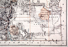
Map of the Malheur Reservation drawn by the U.S. General Land Office
484:
222:
30:
22:
466:
192:, under pressure from settlers, ordered the northern shores of
584:"Settling Up the Country: Social Costs of the Cattlemen's Era"
560:"Bannock War" (mistakenly titled Rogue River War on the page)
550:, Idaho State Historical Society. Retrieved January 31, 2016.
209:
The reservation straddled trails between then northern
63:, led to the internment of more than 500 Paiute on the
261:
They were later joined there during the summer by the
221:had received orders to move with his people to
8:
469:, Burns, Oregon. Retrieved January 31, 2016.
178:changes to the boundaries of the reservation
83:set aside the Malheur Indian Reservation in
414:, University of Oklahoma Press, 1988, p. 94
572:"Native American History: The Bannock War"
497:
495:
493:
480:Census of Indians in Eastern Oregon, 1865.
612:Malheur Indian Reservation (includes map)
387:
385:
411:Sarah Winnemucca of the Northern Paiutes
381:
342:(or the Burns Paiute Colony) along the
258:, making it relatively easy to defend.
646:American Indian reservations in Oregon
370:List of Indian reservations in Oregon
7:
160:rivers into the North Fork from the
132:The reservation covered roughly the
656:Former American Indian reservations
269:units under the command of General
233:, for shipment to the East. In the
451:Treaties and Reservations Created.
14:
661:Native American history of Oregon
360:Fort McDermitt Indian Reservation
393:Harney County and Its Range Land
527:, June 4, 1878 (.PDF download).
340:Burns Paiute Indian Reservation
334:Burns Paiute Indian Reservation
596:"The Fight to Regain the Land"
537:"Bannock War at Camas Prairie"
328:Commissioner of Indian Affairs
1:
666:1872 establishments in Oregon
485:The Oregon Historical Project
265:coming west from Idaho. When
586:, The Oregon History Project
124:of the Paiute, his daughter
297:Removal and discontinuation
682:
176:settlers began requesting
41:Malheur Indian Reservation
15:
616:Oregon Historical Society
391:Brimlow, George Francis.
330:discontinued the agency.
303:Yakama Indian Reservation
168:Reductions and incursions
75:On September 12, 1872, a
65:Yakama Indian Reservation
409:Gae Whitney Canfield,
152:still migrated up the
36:
28:
651:Harney County, Oregon
199:Suaeda calceoliformis
34:
26:
395:, Portland, Oregon:
307:Washington Territory
246:The outbreak of the
172:Almost immediately,
47:established for the
397:Binfords & Mort
61:William V. Rinehart
562:, Global Security.
542:2015-12-20 at the
487:, January 31, 2016
467:Burns Paiute Tribe
461:2016-01-31 at the
311:Vancouver Barracks
242:Bannock War (1878)
231:Winnemucca, Nevada
229:railheads such as
77:presidential order
45:Indian reservation
37:
29:
436:Canfield (1988),
423:Canfield (1988),
399:, 1951, pp. 90-1.
174:European American
673:
599:
593:
587:
581:
575:
569:
563:
557:
551:
548:Reference Series
534:
528:
516:
510:
501:Brimlow (1951),
499:
488:
476:
470:
447:
441:
438:Sarah Winnemucca
434:
428:
425:Sarah Winnemucca
421:
415:
406:
400:
389:
346:, just north of
271:Oliver O. Howard
104:in northeastern
81:Ulysses S. Grant
43:was an American
681:
680:
676:
675:
674:
672:
671:
670:
641:Northern Paiute
626:
625:
608:
603:
602:
594:
590:
582:
578:
570:
566:
558:
554:
544:Wayback Machine
535:
531:
520:The Bannock War
517:
513:
500:
491:
477:
473:
463:Wayback Machine
448:
444:
435:
431:
422:
418:
407:
403:
390:
383:
378:
356:
336:
313:in Washington.
299:
283:Umatilla Agency
252:Steens Mountain
244:
227:Central Pacific
184:Valley and the
170:
98:Southern Oregon
73:
49:Northern Paiute
21:
12:
11:
5:
679:
677:
669:
668:
663:
658:
653:
648:
643:
638:
628:
627:
624:
623:
618:
607:
606:External links
604:
601:
600:
588:
576:
564:
552:
529:
525:New York Times
511:
489:
471:
456:Paiute History
442:
429:
416:
401:
380:
379:
377:
374:
373:
372:
367:
362:
355:
352:
335:
332:
321:under General
298:
295:
275:Blue Mountains
243:
240:
169:
166:
134:drainage basin
122:Old Winnemucca
110:Fort McDermitt
85:Eastern Oregon
72:
69:
13:
10:
9:
6:
4:
3:
2:
678:
667:
664:
662:
659:
657:
654:
652:
649:
647:
644:
642:
639:
637:
636:Bannock tribe
634:
633:
631:
622:
619:
617:
613:
610:
609:
605:
597:
592:
589:
585:
580:
577:
573:
568:
565:
561:
556:
553:
549:
545:
541:
538:
533:
530:
526:
522:
521:
515:
512:
508:
505:, pp. 81-130
504:
503:Harney County
498:
496:
494:
490:
486:
482:
481:
475:
472:
468:
464:
460:
457:
453:
452:
446:
443:
439:
433:
430:
426:
420:
417:
413:
412:
405:
402:
398:
394:
388:
386:
382:
375:
371:
368:
366:
363:
361:
358:
357:
353:
351:
349:
348:Burns, Oregon
345:
344:Silvies River
341:
333:
331:
329:
324:
320:
314:
312:
308:
304:
296:
294:
292:
288:
284:
279:
276:
272:
268:
264:
259:
257:
256:Alvord Desert
253:
249:
241:
239:
236:
232:
228:
224:
220:
216:
212:
207:
205:
201:
200:
195:
191:
187:
183:
182:Silvies River
179:
175:
167:
165:
163:
162:Pacific Ocean
159:
155:
151:
147:
146:Malheur River
144:forks of the
143:
140:, Middle and
139:
135:
130:
127:
123:
119:
115:
111:
107:
103:
99:
95:
91:
86:
82:
78:
71:Establishment
70:
68:
66:
62:
58:
54:
50:
46:
42:
33:
25:
19:
591:
579:
567:
555:
532:
524:
519:
514:
506:
502:
479:
474:
450:
445:
437:
432:
424:
419:
410:
404:
392:
365:Harney Basin
337:
315:
300:
280:
260:
245:
215:Chief Joseph
211:Grant County
208:
203:
197:
194:Malheur Lake
171:
131:
112:in northern
102:Fort Bidwell
74:
40:
38:
440:, pp. 44-45
248:Bannock War
235:high desert
186:Harney Lake
120:. In 1875,
57:Bannock War
51:in eastern
630:Categories
376:References
267:U. S. Army
106:California
281:Near the
219:Nez Perce
540:Archived
459:Archived
354:See also
287:Umatilla
213:, where
204:Wadatika
156:and the
154:Columbia
621:Paiutes
427:, p. 92
263:Bannock
217:of the
136:of the
94:Klamath
18:Malheur
507:passim
150:salmon
114:Nevada
108:, and
90:Harney
53:Oregon
614:from
323:Crook
305:, in
223:Idaho
190:Grant
158:Snake
142:North
138:South
126:Sarah
319:West
291:Egan
118:Egan
92:and
39:The
96:in
79:by
632::
546:,
523:,
492:^
483:,
465:,
454:,
384:^
164:.
100:,
574:.
509:.
20:.
Text is available under the Creative Commons Attribution-ShareAlike License. Additional terms may apply.