70:
160:
376:
141:
1123:. It extends into Stara Borča and Centar I on the south, Centar II on the east and Borča Greda on the north-east. Northern and western border of Centar III is marked by the Pretok canal and an unurbanized area across it, while in the south-west the neighborhood meets the Vizelj river. West, right across the Vizelj is occupied by the sport fields of the
987:. It is also called Mokri Sebeš (Wet Sebeš) or Borčanski Sebeš. Named after the river-turned-canal Sebeš which flows into Vizelj further south and marks the southern border of the neighborhood but also of the entire Borča. It extends into Stara Borča and Centar I on the west, Zrenjaninski Put on the north and Popova Bara on the east, across the road of
77:
54:
884:
1222:(west) and the Pretok canal (north). It borders the neighborhoods of Centar IV on the south-west and Mali Zbeg on the north, across the Pretok. Because of its white buildings, it has been nicknamed "Sivi Dom" after very popular 1986 Serbian TV serial "Sivi dom" (literally, "grey home"), about a correctional facility in central Serbia.
908:
and comprises most diverse neighborhoods of Borča: the original, oldest section in the south-west, those closest to
Belgrade, easternmost sections which extends to Ovča and the south-western extension in the direction of the Danube. It had a population of 7,928 in 1991, 13,624 in 2002 and 20,188 in
623:
When construction of the Pupin Bridge was coming to an end in 2014, building of a massive industrial park by the
Chinese investors at the Borča side of the bridge was announced. This was confirmed by the government in 2020 and 2021, when the project was called Mihajlo Pupin Industrial Park, and was
561:
As Pančevački Rit is a floodplain, during extremely high levels of the Danube (especially in 1826, 1888 and 1924), entire area and settlements in it were completely flooded turning the marsh into a large lake. It was recorded that during the floods of 1924, rescue ships had to maneuver between the
1256:
Large cemetery of "Zbeg" is located just north of the neighborhood. Plan for the cemetery was adopted in 1994, and in 1996 "Zbeg" became operational. Chief planner was architect
Slobodanka Prekajski. The cemetery covers an area of 29 ha (72 acres) and has no church, but the Church of the
1079:
street and the Square of
Liberation. It borders the neighborhoods of Centar III on the north, Centar I on the north-east, Sebeš on the west and extends into Crvenka further into the south-west. Generally considered the calmest part of Borča, it is mostly made of individual residential houses,
1159:
street running through the central parts of the municipality. It borders the neighborhoods of Centar IV in the north-west, Centar II on the north-east, Centar III on the south and Mali Zbeg on the north, across the Pretok. Neighborhood originates from the early 1950s and was originally named
811:
In 1727, 39 households were recorded in the settlement. In 1843 it had 675 inhabitants while in 1859 there were 124 households. In 1910, by the last census in
Austria-Hungary in had a population of 1,535. Since the 1960s Borča began a massive development with rapid population growth having a
896:), sub-municipal administrative units: Stara Borča (formerly Borča I, 1991-2002), Borča Greda (formerly Borča II) and Nova Borča (formerly Borča III). Most of Borča is grouped into centers (Centar I to V), which are sometimes referred to as Borča I to V (Centar I = Borča I, etc.).
628:". In March 2023 construction of the access infrastructure to the future construction site was announced. The park will cover 483.5 ha (1,195 acres), divided in three sections - commercial center, industrial park and high-tech park. The entire complex will be patterned after
997:(Слатина; "salt marsh"); eastern extension, developed along the road to Ovča. As a curiosity, majority of the streets in the neighborhood, previously known all as Slatina with different numbers added to distinguish them, are recently being named after (ancient) Greek toponyms:
639:
In
December 2021, city announced restoration of the riverine public transportation, which was discontinued decades ago. One of the first two proposed lines should be Borča-Ada Huja. In the same month, construction of the pier at Ada Huja began. New mayor
1099:
Local community of Nova Borča (New Borča) occupies the east-central corner of Borča. Unlike Stara Borča and Borča Greda, it comprises only one sub-neighborhood, Centar III. It had a population of 9,640 in 1991, 14,875 in 2002 and 7,298 in 2011.
562:
telephone poles and that dead were buried from the boats. In 1929-1933 an 89 kilometer-long embankment was built which protected Borča from further floodings. At the same time, road and railway connecting Borča to
Belgrade were also built.
1144:. The fastest growing sections of Borča, like Pretok or Mali Zbeg, are located in this local community, so it more than doubled its population between the 2002 and 2011 censuses: 9,327 in 1991, 8,087 in 2002 and 18,600 in 2011.
1307:, with massive expansion of the neighborhoods on the east (Pretok, Guvno, Popova Bara, Slatina, etc.), Zrenjaninski Put basically becomes central part of the entire neighborhood. It expands during almost entire run of the
891:
As one of the largest suburbs of
Belgrade and a large settlement in its own right, Borča developed several sub-neighborhoods of its own. Officially, after the 1981 census, Borča is divided into three "local communities"
1373:"2011 Census of Population, Households and Dwellings in the Republic of Serbia: Comparative Overview of the Number of Population in 1948, 1953, 1961, 1971, 1981, 1991, 2002 and 2011, Data by settlements"
503:
in 1743 the entire village of Borča was burned to the ground. The new settlement emerged around the sentry post of Stara Borča (Alt Borcsa) in 1794 which became center of a municipality as part of the
1258:
1254:(south). One of the fastest growing parts of Borča. The Pretok canal, which makes southern border of Mali Zbeg, separates it from the neighborhoods of Borča Greda, Centar IV and Centar V.
1890:
518:, a Serb autonomous region within Habsburg Monarchy, but in 1849 it was again placed under administration of the Military Frontier. After transformation of Habsburg Monarchy into the
1178:(southern). It extends into Centar III on the south-west, Borča Greda on the west, Center IV and Center V on the north and Zrenjaninski Put on the east. Open green market (old one,
1236:, in the section where a regional road for Ovča separates. It extends into Pretok on the north, Popova Bara in the south and Zrenjaninski Put, across the road of the same name.
1518:
1327:
Street, at the Borča 3 roundabout of the bus lines 85, 95, 96 and 105L. It covers an area of 3,354 m (36,100 sq ft) and was renovated in
November 2017.
1263:
The name of the locality came from the
Austrian period, when it was the gathering place of the refugees who fled across the river from the Ottoman held Serbia.
522:
in 1867 and abolition of the Military Frontier on 27 June 1873 Borča became part of the Hungarian half of the monarchy, as part of the Pančevo district within
1757:
Branka Vasiljević (10 December 2018). "Почивалишта настала с краја прошлог века" [Resting places originating from the end of the previous century].
400:
and coins from the 3rd and 4th century BC are also found. Because of the marshy area, not much is preserved, but the remains which confirm presence of the
44:
1895:
1503:
566:
1320:
There are only few parks in Borča, and they are small. One, called Mali park (Small Park, formerly Park Sonje Marinković), is located in Borča I.
1665:
1641:
1462:
1414:
1383:
1311:, connecting many other neighborhoods (Sebeš, Centar II, Centar V on the western side and Pretok, Guvno and Popova Bara on the eastern side).
269:
1293:, which made it another fast growing part of Borča. It borders the neighborhoods of Pretok on the south and Zrenjaninski Put on the east.
859:
171:
1478:
101:
1615:
69:
1845:
1832:
1818:
1438:
947:(Иргот); south-western part of Stara Borča. It is located around the church, in the curve made by the Vizelj river, south of the
1204:. It extends into Borča Greda on the south-west, Centar V on the north-east and Mali Zbeg on the north, across the Pretok canal.
440:
possibly derived from Slavic word "bara" meaning "swamp" in English, indicating the settlement's position in the swampy area of
1343:
1075:(Стара Борча); as the name suggests, the oldest part of the entire settlement. It occupies the south-west corner, south of the
904:
Local community of Stara Borča (Old Borča) occupies the entire southern section of the settlement. It extends on both sides of
526:
1634:
Comparative overview of the number of population in 1948, 1953, 1961, 1971, 1981, 1991, 2002 and 2011 – Data by settlements
1537:
1885:
644:, however, stated in July 2022 that the project will not be pursued further, calling it too expensive and "pointless".
1900:
1596:
259:
865:
1140:
Local community of Borča Greda occupies the entire northern section of the settlement, extending on both sides of
284:
1739:
815:
Following the official data, Borča is the largest single suburb of Belgrade. However, unofficial estimates put
133:
585:). Between 1941 and 1944 it was occupied by German troops and included into German-ruled autonomous region of
324:
section of the municipality of Palilula, at an altitude of 78 m (256 ft). It stretches between the
1687:
Stanovništvo prema migracionim obeležjima – SFRJ, SR i SAP, opštine i mesne zajednice 31.03.1991, tabela 018
1577:
1183:
296:
1286:
247:
152:
641:
586:
616:
merged into one named Krnjača. In turn, this municipality was annexed to the Belgrade's municipality of
484:
1372:
1242:(Мали Збег; "little refuge"); the northernmost part of Borča, across the canal and east of the road of
597:
441:
345:
232:
176:
604:
of Belgrade. Borča got its own municipality again on 30 May 1952 but in 1955 with municipalities of
1791:
Branka Vasiljević (30 November 2017), "Uređen park in Borča" [Park in Borča was arranged],
476:
449:
499:
in 1739 Habsburg Monarchy obliged to tear down the fortifications, but due to the outbreak of the
1107:(Центар III); entire settlement is constructed as a series of a parallel, half-circular streets:
496:
429:
1841:
1828:
1814:
1661:
1637:
1497:
1458:
1434:
1410:
1379:
938:
617:
515:
508:
1618:[Šapić: Vesić gave away tablets to pupils, so now we have no money for some things].
1192:(Центар IV); smallest of all five centers. It occupies five buildings between the streets of
573:), being taken by the Serbian army on 9 November 1918. From 1918 to 1922, it was part of the
1658:
2022 Census of Population, Households and Dwellings : Age and sex - data by settlements
1482:
1229:
1081:
853:
519:
462:
53:
1561:[Partner for the riverine public transportation (will be selected) in February].
577:
county, from 1922 to 1929 part of the Belgrade oblast, and from 1929 to 1941 part of the
471:-Ottoman wars, Borča became center of the Ottoman border zone and was heavily fortified (
980:
613:
364:
360:
1303:
road"); once easternmost part of Borča, located along the western side of the road of
537:
were in an absolute majority in Borča. Other ethnic groups in the settlement included
1879:
1290:
957:(Попова бара; "priest's pond"); east-central and east-southern extension, across the
841:
816:
504:
445:
320:
Borča is located just 8 km (5.0 mi) north of the downtown Belgrade, in the
1323:
Another, called Park Centar 3 (formerly Park JNA) is located along the curve of the
375:
550:
409:
1124:
523:
500:
1151:(Борча Греда); north-western extension of Borča, located between the street of
1030:
984:
609:
582:
570:
542:
401:
389:
356:
1281:. It developed in the late 1990s and was mostly settled by the refugees from
934:. It borders the neighborhoods of Stara Borča on the west, Sebeš on the east.
116:
103:
1660:. Belgrade: Statistical Office of the Republic of Serbia. 2023. p. 78.
1636:. Belgrade: Statistical Office of the Republic of Serbia. 2014. p. 29.
1300:
1058:
847:
546:
530:
480:
388:
Earliest remains in the vicinity of modern settlement of Borča are from the
333:
329:
217:
1182:) is located in the center of the neighborhood. Next to he market, a large
979:(Себеш); southern extension which makes one continuous built-up area with
819:
in first place. Borča is statistically classified as an urban settlement.
1793:
1026:
970:
633:
625:
578:
468:
397:
393:
337:
305:
164:
159:
17:
1616:"Šapić: Vesić đacima podelio tablete i posle nemamo para za neke stvari"
1166:(Центар II); north-central extension, mostly bordered by the streets of
565:
After the collapse of Austria-Hungary in 1918, Borča became part of the
1282:
1054:
1038:
1014:
1006:
666:
605:
538:
405:
1269:(Преток; "overspill"); north-eastern extension of Borča, west of the
1062:
1050:
1034:
1022:
1010:
998:
973:
river, while the central bart in between is still mainly unurbanized.
871:
828:
629:
590:
341:
309:
239:
222:
145:
140:
1706:
Popis stanovništva po mesnim zajednicama, Saopštenje 40/2002, page 4
1542:[Construction of the industrial park in Borča begins soon].
922:(Центар Ι); central part of Borča, mainly bounded by the streets of
883:
1599:[New Belgrade's new administration (elected) by 27. July].
1066:
1046:
1018:
1002:
882:
835:
601:
574:
534:
457:
433:
321:
301:
1708:. Zavod za informatiku i statistiku grada Beograda. 26 July 2002.
1042:
453:
456:
status. Already in 1567 Borča was predominantly settled by the
596:
In 1949 the municipality was disbanded and the entire area of
1727:. Grad Beograd – Sektor statistike (xls file). 23 April 2015.
379:
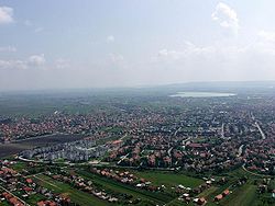
Borča visible in lower right area of aerial image of Belgrade
1860:, Vol. I (1955); Jugoslavenski leksikografski zavod, Zagreb;
1378:. Statistical Office of Republic Of Serbia, Belgrade. 2014.
661:
1776:[About names of some settlements around Belgrade].
487:
in 1718 was formally handed over to the Habsburg Monarchy.
1725:
Stanovništvo po opštinama i mesnim zajednicama, Popis 2011
420:
Borča was mentioned for the first time in 1375 under name
312:. As of 2011, it has a population of 46,086 inhabitants.
1870:
1127:
football club. Cemetery and open green market (new one,
916:(Атови, "horses"); easternmost extension, close to Ovča.
1090:(Вихор; "windstorm"); eastern extension, close to Ovča.
344:, which flows through the middle of the marshy area of
1155:
on the south and the Pretok canal on the north, with
812:
population of 46,086 by the official census in 2011.
348:, the northern part of the municipality of Palilula.
636:. Estimated length of the construction is 19 years.
553:
during World War I (6 September - 14 October 1914).
268:
258:
246:
229:
216:
208:
200:
195:
187:
182:
170:
151:
132:
32:
1539:Ускоро почиње изградња индустријског парка у Борчи
1232:"); north-eastern extension of Borča, west of the
961:. Consists of two sections, northern, around the
300:) is an urban settlement of the municipality of
1825:Enciklopedijski geografski leksikon Jugoslavije
1891:Former and proposed municipalities of Belgrade
428:). Settlement was under administration of the
1742:[Healthcare center in Borča opened].
1597:"Novo novobeogradsko rukovodstvo do 27. jula"
328:road (which connects Belgrade to the town of
8:
969:) and southern, on the northern bank of the
652:
1838:Uporedni pregled broja stanovnika 1948-2002
1259:Translation of the Relics of Saint Nicholas
1210:(Центар V); located between the streets of
363:) and to the north (suburban settlement of
351:As Borča developed, it stretched along the
1871:Borca All information in one place - Borča
1353:(in Serbian). Statistical Office of Serbia
1186:was built from December 2019 to July 2021.
651:
29:
1813:, Third edition (1986), Vol.I; Prosveta;
1689:. Savezni zavod za statistiku (txt file).
1521:[Borča getting industrial park].
567:Kingdom of the Serbs, Croats and Slovenes
1840:(2004); Republički zavod za statistiku;
1774:О називима појединих насеља око Београда
1719:
1717:
1715:
1700:
1698:
1696:
1681:
1679:
1677:
1580:[Pontoon appeared on Ada Huja].
1559:У фебруару партнер за речни јавни превоз
374:
1433:. Smedrevska Palanka: M@gic M@p. 2006.
1335:
1273:. Main streets in the neighborhood are
1246:. Main streets in the neighborhood are
267:
245:
215:
194:
181:
131:
96:
62:
50:
1740:"Otvorena zdravstvena stanica u Borči"
1576:Branka Vasiljević (23 December 2021).
1502:: CS1 maint: archived copy as title (
1495:
1772:Dragan Stanković (17 October 2020).
581:City Administration (the District of
416:Kingdom of Hungary and Ottoman Empire
295:
257:
228:
207:
199:
191:56.61 km (21.86 sq mi)
186:
169:
150:
7:
1536:Mirjana Avakumović (17 March 2023).
1405:Tamara Marinković-Radošević (2007).
514:In 1848-1849, Borča belonged to the
27:Urban settlement in Belgrade, Serbia
1557:Dejan Aleksić (23 December 2021).
432:, although its name imply possible
1131:) are located in the neighborhood.
444:). In 1537 it was captured by the
336:) and the slow streams of Pretok,
25:
1896:Populated places in Serbian Banat
1080:resembling in form other typical
549:. Borča was shortly taken by the
89:Location of Borča within Belgrade
1519:"Borča dobija industrijski park"
1517:Nikola Vojnović (23 June 2021).
158:
139:
75:
68:
52:
479:but was still conquered by the
1595:Dejan Aleksić (22 July 2022).
467:was written in it. During the
288:
1:
1811:Mala Prosvetina Enciklopedija
76:
1738:Mina Ćurčić (16 July 2021).
1455:Turističko područje Beograda
507:, a section of the Habsburg
1850:Velimir Marinković (1975):
983:and, further to the south,
827:Ethnic structure of Borča (
1917:
1823:Jovan Đ. Marković (1990):
1578:"Nikao ponton na Adi Huji"
887:Local communities in Borča
1858:Enciklopedija Jugoslavije
1780:(in Serbian). p. 23.
1746:(in Serbian). p. 15.
1603:(in Serbian). p. 18.
1584:(in Serbian). p. 16.
1565:(in Serbian). p. 16.
1546:(in Serbian). p. 11.
1344:"Насеља општине Палилула"
804:
679:—
212:810/km (2,100/sq mi)
97:
63:
51:
42:
1797:(in Serbian), p. 17
1773:
1558:
1538:
36:
1852:Borča - naselje i škola
1184:community health center
1117:Privrednikovih pitomaca
1827:; Svjetlost-Sarajevo;
1409:. Belgrade: Geokarta.
1407:Beograd - plan i vodič
1325:Ratnih vojnih invalida
1287:Bosnia and Herzegovina
1252:Karlovačke mitropolije
1109:Ratnih vojnih invalida
888:
589:, which was a part of
396:, but the medallions,
380:
1614:Beta (21 July 2022).
1279:Mitra Trifunovića Uče
886:
653:Historical population
557:Yugoslavia and Serbia
485:Treaty of Passarowitz
378:
231: • Summer (
1431:Beograd - plan grada
1172:Bratstva i jedinstva
1153:Bratstva i jedinstva
448:, included into the
209: • Density
1886:Suburbs of Belgrade
1299:(Зрењанински пут; "
654:
529:, seated in modern
483:in 1717 and by the
477:Treaty of Karlowitz
450:Sanjak of Smederevo
359:'s neighborhood of
297:[bɔ̂ːrt͡ʃa]
113: /
1901:Palilula, Belgrade
1457:. Geokarta. 2007.
1261:is located nearby.
1176:Ivana Milutinovića
1170:(western border),
1160:"Martinova Greda".
965:street (formerly,
924:Ivana Milutinovića
889:
624:labeled "European
533:. In 1910, ethnic
497:Treaty of Belgrade
430:Kingdom of Hungary
381:
201: • Total
188: • Total
1667:978-86-6161-230-5
1643:978-86-6161-109-4
1464:978-86-459-0099-2
1416:978-86-459-0006-0
1385:978-86-6161-109-4
1234:Zrenjaninski road
1220:Dunavske divizije
1198:Severina Bijelića
1168:Valjevskog odreda
949:Borčanskih žrtava
838:= 30,834 (87.72%)
809:
808:
516:Serbian Vojvodina
509:Military Frontier
491:Habsburg Monarchy
278:
277:
58:Panorama of Borča
16:(Redirected from
1908:
1799:
1798:
1788:
1782:
1781:
1769:
1763:
1762:
1754:
1748:
1747:
1735:
1729:
1728:
1721:
1710:
1709:
1702:
1691:
1690:
1683:
1672:
1671:
1654:
1648:
1647:
1630:
1624:
1623:
1611:
1605:
1604:
1592:
1586:
1585:
1573:
1567:
1566:
1554:
1548:
1547:
1533:
1527:
1526:
1514:
1508:
1507:
1501:
1493:
1491:
1490:
1481:. Archived from
1475:
1469:
1468:
1451:
1445:
1444:
1427:
1421:
1420:
1402:
1396:
1395:
1393:
1392:
1377:
1369:
1363:
1362:
1360:
1358:
1348:
1340:
1309:Zrenjaninski put
1305:Zrenjaninski put
1297:Zrenjaninski Put
1271:Zrenjaninski put
1248:Rastka Nemanjića
1244:Zrenjaninski put
1142:Zrenjaninski put
989:Zrenjaninski put
959:Zrenjaninski put
906:Zrenjaninski put
823:Ethnic structure
668:
663:
655:
642:Aleksandar Šapić
452:and granted the
353:Zrenjaninski put
326:Zrenjaninski put
299:
294:
290:
285:Serbian Cyrillic
236:
163:
162:
144:
143:
128:
127:
125:
124:
123:
118:
114:
111:
110:
109:
106:
79:
78:
72:
56:
45:Urban settlement
30:
21:
1916:
1915:
1911:
1910:
1909:
1907:
1906:
1905:
1876:
1875:
1867:
1807:
1802:
1790:
1789:
1785:
1775:
1771:
1770:
1766:
1756:
1755:
1751:
1737:
1736:
1732:
1723:
1722:
1713:
1704:
1703:
1694:
1685:
1684:
1675:
1668:
1656:
1655:
1651:
1644:
1632:
1631:
1627:
1613:
1612:
1608:
1594:
1593:
1589:
1575:
1574:
1570:
1560:
1556:
1555:
1551:
1540:
1535:
1534:
1530:
1516:
1515:
1511:
1494:
1488:
1486:
1479:"Archived copy"
1477:
1476:
1472:
1465:
1453:
1452:
1448:
1441:
1429:
1428:
1424:
1417:
1404:
1403:
1399:
1390:
1388:
1386:
1375:
1371:
1370:
1366:
1356:
1354:
1346:
1342:
1341:
1337:
1333:
1318:
1262:
1255:
1230:threshing floor
1202:Miladina Zarića
1174:(northern) and
1138:
1097:
932:Narodnog fronta
902:
894:mesna zajednica
881:
844:= 1,296 (3.69%)
825:
650:
559:
520:Austria-Hungary
493:
418:
386:
373:
318:
292:
254:
230:
157:
138:
121:
119:
117:44.87°N 20.45°E
115:
112:
107:
104:
102:
100:
99:
93:
92:
91:
90:
87:
86:
85:
84:
80:
59:
47:
38:
35:
28:
23:
22:
15:
12:
11:
5:
1914:
1912:
1904:
1903:
1898:
1893:
1888:
1878:
1877:
1874:
1873:
1866:
1865:External links
1863:
1862:
1861:
1855:
1848:
1835:
1821:
1806:
1803:
1801:
1800:
1783:
1764:
1749:
1730:
1711:
1692:
1673:
1666:
1649:
1642:
1625:
1606:
1587:
1568:
1549:
1528:
1509:
1470:
1463:
1446:
1439:
1422:
1415:
1397:
1384:
1364:
1334:
1332:
1329:
1317:
1314:
1313:
1312:
1294:
1264:
1237:
1223:
1216:Velikoremetska
1205:
1187:
1161:
1137:
1134:
1133:
1132:
1096:
1093:
1092:
1091:
1085:
1070:
992:
981:Dunavski Venac
974:
952:
942:
935:
917:
901:
898:
880:
879:Neighbourhoods
877:
876:
875:
869:
863:
860:ethnic Muslims
857:
851:
845:
839:
824:
821:
807:
806:
802:
801:
798:
795:
791:
790:
787:
784:
780:
779:
776:
773:
769:
768:
765:
762:
758:
757:
754:
751:
747:
746:
743:
740:
736:
735:
732:
729:
725:
724:
721:
718:
714:
713:
710:
707:
703:
702:
699:
696:
692:
691:
688:
685:
681:
680:
677:
674:
670:
669:
664:
659:
649:
646:
614:Padinska Skela
598:Pančevački Rit
558:
555:
492:
489:
442:Pančevački Rit
417:
414:
385:
382:
372:
369:
365:Padinska Skela
361:Dunavski Venac
355:to the south (
346:Pančevački Rit
317:
314:
276:
275:
272:
266:
265:
262:
256:
255:
252:
250:
244:
243:
237:
227:
226:
220:
214:
213:
210:
206:
205:
202:
198:
197:
193:
192:
189:
185:
184:
180:
179:
174:
168:
167:
155:
149:
148:
136:
130:
129:
95:
94:
88:
82:
81:
74:
73:
67:
66:
65:
64:
61:
60:
57:
49:
48:
43:
40:
39:
33:
26:
24:
14:
13:
10:
9:
6:
4:
3:
2:
1913:
1902:
1899:
1897:
1894:
1892:
1889:
1887:
1884:
1883:
1881:
1872:
1869:
1868:
1864:
1859:
1856:
1853:
1849:
1847:
1846:86-84433-14-9
1843:
1839:
1836:
1834:
1833:86-01-02651-6
1830:
1826:
1822:
1820:
1819:86-07-00001-2
1816:
1812:
1809:
1808:
1804:
1796:
1795:
1787:
1784:
1779:
1768:
1765:
1761:(in Serbian).
1760:
1753:
1750:
1745:
1741:
1734:
1731:
1726:
1720:
1718:
1716:
1712:
1707:
1701:
1699:
1697:
1693:
1688:
1682:
1680:
1678:
1674:
1669:
1663:
1659:
1653:
1650:
1645:
1639:
1635:
1629:
1626:
1622:(in Serbian).
1621:
1617:
1610:
1607:
1602:
1598:
1591:
1588:
1583:
1579:
1572:
1569:
1564:
1553:
1550:
1545:
1541:
1532:
1529:
1525:(in Serbian).
1524:
1520:
1513:
1510:
1505:
1499:
1485:on 2011-10-07
1484:
1480:
1474:
1471:
1466:
1460:
1456:
1450:
1447:
1442:
1440:86-83501-53-1
1436:
1432:
1426:
1423:
1418:
1412:
1408:
1401:
1398:
1387:
1381:
1374:
1368:
1365:
1352:
1345:
1339:
1336:
1330:
1328:
1326:
1321:
1315:
1310:
1306:
1302:
1298:
1295:
1292:
1291:Yugoslav wars
1288:
1284:
1280:
1276:
1272:
1268:
1265:
1260:
1253:
1250:(center) and
1249:
1245:
1241:
1238:
1235:
1231:
1227:
1224:
1221:
1217:
1213:
1209:
1206:
1203:
1199:
1195:
1191:
1188:
1185:
1181:
1177:
1173:
1169:
1165:
1162:
1158:
1157:Ranka Miljića
1154:
1150:
1147:
1146:
1145:
1143:
1135:
1130:
1126:
1122:
1118:
1114:
1110:
1106:
1103:
1102:
1101:
1094:
1089:
1086:
1083:
1078:
1077:Jugoslovenska
1074:
1071:
1068:
1064:
1060:
1056:
1052:
1048:
1044:
1040:
1036:
1032:
1028:
1024:
1020:
1016:
1012:
1008:
1004:
1000:
996:
993:
990:
986:
982:
978:
975:
972:
968:
964:
960:
956:
953:
950:
946:
943:
941:
940:
936:
933:
929:
925:
921:
918:
915:
912:
911:
910:
907:
899:
897:
895:
885:
878:
874:= 232 (0.66%)
873:
870:
868:= 240 (0.68%)
867:
864:
862:= 271 (0.77%)
861:
858:
856:= 464 (1.32%)
855:
852:
850:= 474 (1.35%)
849:
846:
843:
840:
837:
834:
833:
832:
830:
822:
820:
818:
813:
803:
799:
796:
793:
792:
788:
785:
782:
781:
777:
774:
771:
770:
766:
763:
760:
759:
755:
752:
749:
748:
744:
741:
738:
737:
733:
730:
727:
726:
722:
719:
716:
715:
711:
708:
705:
704:
700:
697:
694:
693:
689:
686:
683:
682:
678:
675:
672:
671:
665:
660:
657:
656:
647:
645:
643:
637:
635:
631:
627:
621:
619:
615:
611:
607:
603:
599:
594:
592:
588:
584:
580:
576:
572:
568:
563:
556:
554:
552:
548:
544:
540:
536:
532:
528:
525:
521:
517:
512:
510:
506:
505:Banat Krajina
502:
498:
490:
488:
486:
482:
478:
474:
470:
466:
464:
459:
455:
451:
447:
443:
439:
435:
431:
427:
423:
415:
413:
411:
407:
403:
399:
395:
391:
384:Early history
383:
377:
370:
368:
366:
362:
358:
354:
349:
347:
343:
339:
335:
331:
327:
323:
315:
313:
311:
307:
303:
298:
286:
282:
273:
271:
263:
261:
251:
249:
241:
238:
234:
224:
221:
219:
211:
203:
190:
178:
175:
173:
166:
161:
156:
154:
147:
142:
137:
135:
126:
98:Coordinates:
71:
55:
46:
41:
31:
19:
1857:
1851:
1837:
1824:
1810:
1792:
1786:
1777:
1767:
1758:
1752:
1743:
1733:
1724:
1705:
1686:
1657:
1652:
1633:
1628:
1619:
1609:
1600:
1590:
1581:
1571:
1562:
1552:
1543:
1531:
1522:
1512:
1487:. Retrieved
1483:the original
1473:
1454:
1449:
1430:
1425:
1406:
1400:
1389:. Retrieved
1367:
1355:. Retrieved
1350:
1338:
1324:
1322:
1319:
1308:
1304:
1296:
1278:
1274:
1270:
1266:
1251:
1247:
1243:
1239:
1233:
1225:
1219:
1215:
1211:
1207:
1201:
1197:
1193:
1189:
1180:Stara pijaca
1179:
1175:
1171:
1167:
1163:
1156:
1152:
1148:
1141:
1139:
1128:
1120:
1116:
1113:Bele Bartoka
1112:
1108:
1104:
1098:
1087:
1084:settlements.
1076:
1072:
994:
988:
976:
966:
962:
958:
954:
948:
944:
937:
931:
927:
923:
919:
913:
905:
903:
893:
890:
826:
814:
810:
638:
622:
595:
564:
560:
551:Serbian army
513:
494:
475:) after the
472:
461:
460:when famous
437:
425:
421:
419:
412:were found.
387:
352:
350:
325:
319:
280:
279:
172:Municipality
122:44.87; 20.45
1351:stat.gov.rs
1149:Borča Greda
1136:Borča Greda
1129:Nova pijaca
1073:Stara Borča
967:Popova bara
955:Popova Bara
900:Stara Borča
866:Macedonians
473:Porača fort
436:root (Name
404:(including
248:Postal code
120: /
1880:Categories
1489:2011-06-28
1391:2014-06-27
1357:22 October
1331:References
1194:Kovilovska
1121:Prelivačka
1105:Centar III
1095:Nova Borča
1031:Cappadocia
963:Androvačka
817:Kaluđerica
648:Population
600:became IX
571:Yugoslavia
543:Hungarians
495:After the
402:Sarmatians
293:pronounced
270:Car plates
196:Population
1301:Zrenjanin
1275:Kikindska
1240:Mali Zbeg
1228:(Гувно; "
1218:(south),
1190:Centar IV
1164:Centar II
1125:BSK Borča
1082:Pannonian
1059:Epidaurus
848:Yugoslavs
620:in 1965.
547:Romanians
531:Zrenjanin
527:comitatus
481:Habsburgs
398:figurines
334:Vojvodina
330:Zrenjanin
264:+381(0)11
260:Area code
218:Time zone
18:Mali Zbeg
1794:Politika
1778:Politika
1759:Politika
1744:Politika
1601:Politika
1582:Politika
1563:Politika
1544:Politika
1498:cite web
1214:(west),
1212:Hopovska
1208:Centar V
1027:Pergamon
920:Centar I
805:Source:
634:Shanghai
626:Shenzhen
618:Palilula
579:Belgrade
569:(future
524:Torontál
469:Habsburg
446:Ottomans
394:Iron Age
316:Location
306:Belgrade
165:Belgrade
1805:Sources
1289:during
1283:Croatia
1055:Antioch
1039:Corinth
1015:Ephesus
1007:Boeotia
995:Slatina
985:Krnjača
951:street.
939:Crvenka
831:2002):
667:±% p.a.
632:, near
610:Krnjača
583:Pančevo
539:Germans
406:Iazyges
371:History
357:Krnjača
134:Country
108:20°27′E
105:44°52′N
1844:
1831:
1817:
1664:
1640:
1461:
1437:
1413:
1382:
1267:Pretok
1069:, etc.
1063:Phocis
1051:Sparta
1035:Delphi
1023:Nicaea
1011:Angora
999:Epirus
909:2011.
872:Croats
854:Gorani
842:Romani
829:census
800:+1.08%
797:51,862
789:+3.06%
786:46,086
778:+2.46%
775:35,150
767:+3.79%
764:26,895
756:+6.93%
753:18,549
745:+8.16%
734:+3.13%
723:−0.85%
712:+4.31%
701:−0.76%
690:−0.24%
630:Xuzhou
591:Serbia
501:plague
465:Gospel
438:Barcsa
434:Slavic
426:Bercse
422:Barcsa
410:Romans
408:) and
390:Bronze
342:Vizelj
310:Serbia
242:(CEST)
204:46,086
153:Region
146:Serbia
1376:(PDF)
1347:(PDF)
1316:Parks
1226:Guvno
1088:Vihor
1067:Pilos
1047:Volos
1019:Milet
1003:Morea
977:Sebeš
971:Sebeš
945:Irgot
928:Lička
914:Atovi
836:Serbs
742:9,487
731:4,330
720:3,384
709:3,532
698:1,724
687:1,860
676:1,910
602:Raion
587:Banat
575:Banat
535:Serbs
463:Jazak
458:Serbs
340:and
338:Sebeš
322:Banat
302:Zemun
289:Борча
281:Borča
253:11211
240:UTC+2
225:(CET)
223:UTC+1
177:Zemun
83:Borča
37:Борча
34:Borča
1842:ISBN
1829:ISBN
1815:ISBN
1662:ISBN
1638:ISBN
1523:Blic
1504:link
1459:ISBN
1435:ISBN
1411:ISBN
1380:ISBN
1359:2019
1285:and
1277:and
1200:and
1043:Troy
930:and
794:2022
783:2011
772:2002
761:1991
750:1981
739:1971
728:1961
717:1953
706:1948
695:1931
684:1921
673:1910
662:Pop.
658:Year
612:and
606:Ovča
545:and
454:waqf
424:(or
392:and
183:Area
367:).
332:in
233:DST
1882::
1714:^
1695:^
1676:^
1620:N1
1500:}}
1496:{{
1349:.
1196:,
1119:,
1115:,
1111:,
1065:,
1061:,
1057:,
1053:,
1049:,
1045:,
1041:,
1037:,
1033:,
1029:,
1025:,
1021:,
1017:,
1013:,
1009:,
1005:,
1001:,
926:,
608:,
593:.
541:,
511:.
308:,
304:,
291:,
287::
274:BG
1854:;
1670:.
1646:.
1506:)
1492:.
1467:.
1443:.
1419:.
1394:.
1361:.
991:.
892:(
283:(
235:)
20:)
Text is available under the Creative Commons Attribution-ShareAlike License. Additional terms may apply.