1047:
41:
1097:
29:
481:
on the
Mamberamo that would have submerged much of the area. This plan was shelved after the Indonesian financial crisis from 1998 to 1999, but there are concerns by environmental groups that it could be resurrected sometime in the future. At present, the Mamberamo remains the second largest river in
1119:
covers an area of 16,610 km, extending along the
Mamberamo and its major tributaries from the Central Range foothills to the Pacific Ocean. It encompasses the central Lakes Plains region and extends southwards along the eastern side of the river to include the Foya Mountains, the river delta,
1211:
1046:
509:. The scientific team discovered the first new bird species from New Guinea in 60 years, and a wealth of other new plants and animals. The Foya Mountains appear to be a globally outstanding repository of biodiversity.
1466:
529:, it covers a total distance of 1,112 km (691 mi). It has a catchment area of 79,000 km (31,000 sq mi) with an annual rainfall of 3,578 mm (
1742:
450:
through a series of rapids and gorges. The last 160 km of the river are navigable. In the coastal lowlands, the river is lined with marshes and forms a broad
1459:
1313:
2339:
107:
1452:
1280:
1233:
2518:
1475:
1141:
1089:) rowed up the river to ascertain that it was navigable by steamer. The following year in 1884 Van Braam Morris returned to the steamship
175:
2678:
2470:
1890:
1735:
1435:
1146:
997:
530:
502:
1116:
1110:
2442:
2140:
1728:
1180:
1178:
1176:
1174:
1172:
2153:
1752:
1711:
412:
69:
2241:
498:
1330:
920:
438:
region, an interior basin with extensive freshwater swamp forests and grasslands. It flows northwards between the
2400:
1764:
1296:
1156:
1151:
2683:
2385:
2226:
1392:
1129:
2366:
2415:
1059:
506:
474:
1077:
The first
European to enter the mouth of the Mamberamo was Dutchman Dr D. F. van Braam Morris in 1883. The
2526:
2452:
2347:
2204:
2013:
1870:
1510:
1346:
Prof. Dr. Ir., San Afri Awang; Sasmita, Nugroho; Dr., Julijanti; Isluyandari, Woelan
Yanuartanti (2019).
1050:
The upper
Mamberamo River was photographed during the Central-North New Guinea Expedition led by Le Roux
493:
The
Mamberamo area also broadly refers to several nearby mountain ranges, including the Van Rees and
1347:
537:). Average width is 175–800 m (574–2,625 ft), depth 8 m (26 ft) (maximum 33 m).
1062:
sailed along the northern coast of the island as far as the mouth of this river that he charted as
466:
1367:
1240:
497:(also known as Foya), which were the subject of a recent rapid biological assessment conducted by
2623:
1981:
1956:
1848:
1479:
1132:
with 235 meters and 270 meters respectively until the latter bridge collapsed in
November 2011.
2361:
1922:
1799:
1431:
478:
1186:
2581:
2406:
2309:
2254:
1927:
1660:
1078:
643:
2456:
2429:
2299:
1934:
1902:
1897:
1821:
1789:
1410:
Conservation and
Development in Irian Jaya: A Strategy for Rational Resource Utilization
2657:
2576:
2566:
2541:
2493:
2488:
2448:
2437:
2425:
2221:
2211:
2187:
2078:
1875:
1838:
1804:
1695:
1690:
1650:
1630:
1545:
740:
615:
522:
494:
447:
431:
371:
333:
225:
93:
1187:
Country Report
Implementation of Demonstration Project Mamberamo River Basin Indonesia
2672:
2645:
2630:
2618:
2551:
2498:
2421:
2380:
2376:
2329:
2324:
2274:
2269:
2259:
2231:
2199:
2175:
2160:
2095:
2083:
2073:
2068:
2031:
1996:
1986:
1961:
1939:
1831:
1826:
1809:
1794:
1675:
1620:
1605:
1600:
1565:
1555:
1540:
1500:
1490:
455:
325:
148:
40:
2650:
2608:
2603:
2586:
2571:
2561:
2531:
2508:
2433:
2319:
2294:
2289:
2284:
2279:
2264:
2249:
2170:
2165:
2148:
2130:
2125:
2115:
2041:
1966:
1949:
1865:
1843:
1777:
1685:
1670:
1645:
1625:
1590:
1585:
1580:
1520:
1515:
1505:
1495:
1263:
758:
724:
594:
526:
518:
470:
435:
427:
420:
359:
89:
1128:
The
Mamberamo Bridge was the second longest cable-stayed span in Indonesia after
2640:
2635:
2613:
2546:
2536:
2391:
2372:
2357:
2353:
2216:
2182:
2120:
2105:
2046:
2026:
2003:
1991:
1976:
1912:
1907:
1885:
1860:
1855:
1816:
1782:
1700:
1665:
1635:
1610:
1570:
1550:
1535:
451:
396:
143:
1444:
1096:
28:
2598:
2593:
2503:
2483:
2460:
2410:
2395:
2314:
2304:
2192:
2110:
2058:
2021:
1971:
1944:
1917:
1880:
1772:
1640:
1595:
1575:
392:
1012:
999:
935:
922:
190:
177:
122:
109:
2478:
2090:
2053:
2036:
1756:
1720:
1655:
1530:
1093:
and travelled 60 mi (97 km) (as the crow flies) along its course.
1067:
487:
483:
416:
408:
404:
161:
59:
1205:
1203:
1201:
1199:
2100:
2063:
1082:
1680:
1086:
400:
1234:"Fragmentation and Flow Regulation of the World's Large River Systems"
426:
The river is formed from the confluence of its upper tributaries, the
1615:
1525:
1325:
1323:
1095:
1066:. At this spot, on 20 June 1545, he claimed the territory for the
1055:
1045:
388:
1724:
1448:
458:
at the northern point of Point D'Urville or Cape Narwaku (
482:
the world to be completely unfragmented by dams in its
1070:, and in the process bestowed the name to the island (
525:
is 283 km (176 mi). From the source of the
1399:, donderdag 5 maart 1885 no. 57. Visited 2 July 2013
1349:
2018 BUKU 1-KAJIAN PENGANYAN PEMBANGUNAN PULAU PAPUA
786:) at delta in 2003–2012: 5,014 m/s (158.23 km/year)
2517:
2469:
2338:
2240:
2139:
2012:
1763:
365:
353:
345:
331:
321:
316:
302:
290:
282:
268:
258:
248:
240:
232:
216:
206:
167:
154:
142:
99:
84:
75:
65:
55:
50:
21:
1228:
1226:
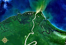
45:Mamberamo, entering the sea, seen from space.
1736:
1460:
975:5,922.9 m/s (209,170 cu ft/s)
8:
1297:"Hydrology and Earth System Sciences (EGU)"
1033:4,532 m/s (160,000 cu ft/s)
984:5,500 m/s (190,000 cu ft/s)
891:5,896 m/s (208,200 cu ft/s)
883:3,691 m/s (130,300 cu ft/s)
875:4,709 m/s (166,300 cu ft/s)
867:3,515 m/s (124,100 cu ft/s)
859:4,157 m/s (146,800 cu ft/s)
851:3,417 m/s (120,700 cu ft/s)
843:4,629 m/s (163,500 cu ft/s)
835:4,374 m/s (154,500 cu ft/s)
827:5,276 m/s (186,300 cu ft/s)
819:6,749 m/s (238,300 cu ft/s)
811:7,749 m/s (273,700 cu ft/s)
803:6,006 m/s (212,100 cu ft/s)
465:The river's huge valley is home to various
1743:
1729:
1721:
1467:
1453:
1445:
1192:(Report). Indonesian Hydrological Society.
308:5,500 m/s (190,000 cu ft/s)
956:163.26346 km/a (5,173.507 m/s)
1213:PENGEMBANGAN PLTA MAMBERAMO TERINTEGRASS
899:
788:
547:
1168:
236:78,992 km (30,499 sq mi)
517:Its length from the confluence of the
18:
545:The main tributaries from the mouth:
399:(1,126 km) and the second largest in
33:Mamberamo River, aerial view in 2017.
7:
1142:List of drainage basins of Indonesia
486:, behind only the relatively nearby
454:. The Mamberamo discharges into the
415:. It is the second largest river in
228:–Waruta 1,112 km (691 mi))
897:Mamberamo River average discharge:
966:158.23 km/a (5,014 m/s)
14:
1332:Pola PSDA Mamberamo Tami Apauvar
1147:Mekong-Mamberamo linguistic area
503:Indonesian Institute of Sciences
39:
27:
1368:"Grafik Neraca Air Pulau Papua"
1282:Ausztrália, Óceánia, Antarktisz
1117:Mamberamo Foja Wildlife Reserve
1111:Mamberamo Foja Wildlife Reserve
1105:Mamberamo Foja Wildlife Reserve
477:had plans to construct a large
1074:) by which it is known today.
992:Mamberamo II Hydro Power Plant
169: • coordinates
101: • coordinates
1:
1013:2.144336000°S 137.860271000°E
533:classifies this area as type
531:Köppen climate classification
419:by volume of discharge after
76:Physical characteristics
1428:New Guinea: The Last Unknown
385:Indonesian: Sungai Mamberamo
220:283 km (176 mi) (
208: • elevation
1100:The Mamberamo River in 2017
1018:-2.144336000; 137.860271000
292: • location
264:8–14 m (26–46 ft)
156: • location
2700:
2679:Rivers of Papua (province)
1408:Petocz, Ronald G. (1989).
1108:
675:Taritatu main tributaries
499:Conservation International
403:by discharge volume after
304: • average
270: • maximum
260: • average
250: • minimum
1709:
1486:
1430:. Angus & Robertson.
1157:Kwerba Mamberamo language
1152:Lower Mamberamo languages
990:
913:
682:
674:
635:
631:
589:
567:
312:
278:
138:
80:
38:
26:
1266:Encyclopaedia Britannica
1185:Joesron, Loebis (2008).
1130:Kutai Kartanegara Bridge
636:Tariku main tributaries
563:Average discharge (m/s)
387:) is the second-longest
367: • right
1210:Agus, Sugiyono (2023).
507:Cenderawasih University
407:. It is located in the
355: • left
274:33 m (108 ft)
1426:Souter, Gavin (1963).
1279:Balázs, Dénes (1978).
1268:. Accessed 7 June 2020
1101:
1051:
782:Average monthly flow (
254:3 m (9.8 ft)
1496:Baliem (Vriendschaps)
1099:
1049:
475:Indonesian Government
423:and also the widest.
123:2.92500°S 138.44167°E
2340:Lesser Sunda Islands
1380:Souter (1963) p. 145
1060:Iñigo Ortiz de Retes
473:. In the 1990s, the
212:0 m (0 ft)
1712:Rivers of Indonesia
1366:Rendy, Firmansyah.
1264:"Mamberamo River".
1009: /
932: /
467:uncontacted peoples
444:Pegunungan Van Rees
317:Basin features
187: /
128:-2.92500; 138.44167
119: /
1480:Western New Guinea
1314:"Papua New Guinea"
1102:
1081:from the northern
1052:
16:River in Indonesia
2666:
2665:
1718:
1717:
1039:
1038:
936:1.467°S 137.900°E
895:
894:
773:
772:
479:hydroelectric dam
391:on the island of
377:
376:
191:1.467°S 137.900°E
2691:
1745:
1738:
1731:
1722:
1611:Pulau (Eilanden)
1469:
1462:
1455:
1446:
1441:
1413:
1406:
1400:
1391:
1387:
1381:
1378:
1372:
1371:
1363:
1357:
1356:
1354:
1343:
1337:
1336:
1327:
1318:
1317:
1310:
1304:
1303:
1301:
1293:
1287:
1286:
1276:
1270:
1261:
1255:
1254:
1252:
1251:
1245:
1239:. Archived from
1238:
1230:
1221:
1220:
1218:
1207:
1194:
1193:
1191:
1182:
1124:Mamberamo Bridge
1024:
1023:
1021:
1020:
1019:
1014:
1010:
1007:
1006:
1005:
1004:137°51′36.9756″E
1002:
947:
946:
944:
943:
942:
937:
933:
930:
929:
928:
925:
900:
789:
560:Basin size (km)
554:Right tributary
548:
368:
356:
336:
305:
293:
271:
261:
251:
202:
201:
199:
198:
197:
192:
188:
185:
184:
183:
180:
134:
133:
131:
130:
129:
124:
120:
117:
116:
115:
112:
102:
43:
31:
19:
2699:
2698:
2694:
2693:
2692:
2690:
2689:
2688:
2684:Mamberamo basin
2669:
2668:
2667:
2662:
2513:
2465:
2334:
2236:
2154:Kapuas (Barito)
2135:
2008:
1759:
1749:
1719:
1714:
1705:
1482:
1473:
1438:
1425:
1422:
1417:
1416:
1407:
1403:
1389:
1388:
1384:
1379:
1375:
1365:
1364:
1360:
1352:
1345:
1344:
1340:
1329:
1328:
1321:
1312:
1311:
1307:
1299:
1295:
1294:
1290:
1278:
1277:
1273:
1262:
1258:
1249:
1247:
1243:
1236:
1232:
1231:
1224:
1216:
1209:
1208:
1197:
1189:
1184:
1183:
1170:
1165:
1138:
1126:
1113:
1107:
1044:
1017:
1015:
1011:
1008:
1003:
1000:
998:
996:
995:
941:-1.467; 137.900
940:
938:
934:
931:
926:
923:
921:
919:
918:
915:Mamberamo Delta
780:
551:Left tributary
543:
515:
469:and incredible
460:Tanjung Narwaku
366:
354:
340:Mamberamo River
332:
303:
297:Mamberamo Delta
291:
269:
259:
249:
209:
196:-1.467; 137.900
195:
193:
189:
186:
181:
178:
176:
174:
173:
170:
157:
127:
125:
121:
118:
113:
110:
108:
106:
105:
100:
46:
34:
17:
12:
11:
5:
2697:
2695:
2687:
2686:
2681:
2671:
2670:
2664:
2663:
2661:
2660:
2655:
2654:
2653:
2643:
2638:
2633:
2628:
2627:
2626:
2621:
2611:
2606:
2601:
2596:
2591:
2590:
2589:
2584:
2579:
2574:
2569:
2564:
2554:
2549:
2544:
2539:
2534:
2529:
2523:
2521:
2515:
2514:
2512:
2511:
2506:
2501:
2496:
2491:
2486:
2481:
2475:
2473:
2467:
2466:
2464:
2463:
2440:
2413:
2398:
2383:
2364:
2344:
2342:
2336:
2335:
2333:
2332:
2327:
2322:
2317:
2312:
2307:
2302:
2297:
2292:
2287:
2282:
2277:
2272:
2267:
2262:
2257:
2252:
2246:
2244:
2238:
2237:
2235:
2234:
2229:
2224:
2219:
2214:
2209:
2208:
2207:
2197:
2196:
2195:
2185:
2180:
2179:
2178:
2173:
2163:
2158:
2157:
2156:
2145:
2143:
2137:
2136:
2134:
2133:
2128:
2123:
2118:
2113:
2108:
2103:
2098:
2093:
2088:
2087:
2086:
2076:
2071:
2066:
2061:
2056:
2051:
2050:
2049:
2044:
2039:
2029:
2024:
2018:
2016:
2010:
2009:
2007:
2006:
2001:
2000:
1999:
1989:
1984:
1979:
1974:
1969:
1964:
1959:
1954:
1953:
1952:
1942:
1937:
1932:
1931:
1930:
1925:
1920:
1910:
1905:
1900:
1895:
1894:
1893:
1888:
1883:
1878:
1868:
1863:
1858:
1853:
1852:
1851:
1841:
1836:
1835:
1834:
1829:
1819:
1814:
1813:
1812:
1807:
1797:
1792:
1787:
1786:
1785:
1775:
1769:
1767:
1761:
1760:
1750:
1748:
1747:
1740:
1733:
1725:
1716:
1715:
1710:
1707:
1706:
1704:
1703:
1698:
1693:
1688:
1683:
1678:
1673:
1668:
1663:
1658:
1653:
1648:
1643:
1638:
1633:
1628:
1623:
1618:
1613:
1608:
1603:
1598:
1593:
1588:
1583:
1578:
1576:Maro (Merauke)
1573:
1568:
1563:
1558:
1553:
1548:
1543:
1538:
1533:
1528:
1523:
1518:
1513:
1508:
1503:
1498:
1493:
1487:
1484:
1483:
1474:
1472:
1471:
1464:
1457:
1449:
1443:
1442:
1436:
1421:
1420:External links
1418:
1415:
1414:
1412:. Brill, 1989.
1401:
1393:'Nieuw Guinea'
1382:
1373:
1358:
1338:
1319:
1305:
1288:
1271:
1256:
1222:
1195:
1167:
1166:
1164:
1161:
1160:
1159:
1154:
1149:
1144:
1137:
1134:
1125:
1122:
1109:Main article:
1106:
1103:
1043:
1040:
1037:
1036:
1034:
1031:
1027:
1026:
988:
987:
985:
982:
979:
978:
976:
973:
970:
969:
967:
964:
960:
959:
957:
954:
950:
949:
911:
910:
907:
904:
893:
892:
889:
885:
884:
881:
877:
876:
873:
869:
868:
865:
861:
860:
857:
853:
852:
849:
845:
844:
841:
837:
836:
833:
829:
828:
825:
821:
820:
817:
813:
812:
809:
805:
804:
801:
797:
796:
793:
779:
776:
771:
770:
767:
764:
761:
756:
753:
752:
749:
746:
743:
737:
736:
733:
730:
727:
721:
720:
717:
714:
711:
710:Sobgair (Air)
707:
706:
703:
700:
697:
693:
692:
689:
686:
683:
681:
677:
676:
672:
671:
668:
665:
662:
660:
656:
655:
652:
649:
646:
641:
638:
637:
633:
632:
629:
628:
625:
622:
619:
613:
610:
609:
606:
603:
600:
598:
591:
590:
587:
586:
581:
576:
571:
565:
564:
561:
558:
555:
552:
542:
539:
514:
511:
495:Foja Mountains
448:Foja Mountains
440:Van Rees Range
434:Rivers in the
375:
374:
369:
363:
362:
357:
351:
350:
347:
343:
342:
337:
329:
328:
323:
319:
318:
314:
313:
310:
309:
306:
300:
299:
294:
288:
287:
284:
280:
279:
276:
275:
272:
266:
265:
262:
256:
255:
252:
246:
245:
242:
238:
237:
234:
230:
229:
218:
214:
213:
210:
207:
204:
203:
171:
168:
165:
164:
158:
155:
152:
151:
146:
140:
139:
136:
135:
103:
97:
96:
88:confluence of
86:
82:
81:
78:
77:
73:
72:
67:
63:
62:
57:
53:
52:
48:
47:
44:
36:
35:
32:
24:
23:
15:
13:
10:
9:
6:
4:
3:
2:
2696:
2685:
2682:
2680:
2677:
2676:
2674:
2659:
2656:
2652:
2649:
2648:
2647:
2644:
2642:
2639:
2637:
2634:
2632:
2629:
2625:
2622:
2620:
2617:
2616:
2615:
2612:
2610:
2607:
2605:
2602:
2600:
2597:
2595:
2592:
2588:
2585:
2583:
2580:
2578:
2575:
2573:
2570:
2568:
2565:
2563:
2560:
2559:
2558:
2555:
2553:
2550:
2548:
2545:
2543:
2540:
2538:
2535:
2533:
2530:
2528:
2525:
2524:
2522:
2520:
2519:Western Papua
2516:
2510:
2507:
2505:
2502:
2500:
2497:
2495:
2492:
2490:
2487:
2485:
2482:
2480:
2477:
2476:
2474:
2472:
2468:
2462:
2458:
2454:
2450:
2447:
2445:
2441:
2439:
2435:
2431:
2427:
2423:
2420:
2418:
2414:
2412:
2408:
2405:
2403:
2399:
2397:
2393:
2390:
2388:
2384:
2382:
2378:
2374:
2370:
2369:
2365:
2363:
2359:
2355:
2352:
2350:
2346:
2345:
2343:
2341:
2337:
2331:
2328:
2326:
2323:
2321:
2318:
2316:
2313:
2311:
2308:
2306:
2303:
2301:
2298:
2296:
2293:
2291:
2288:
2286:
2283:
2281:
2278:
2276:
2273:
2271:
2268:
2266:
2263:
2261:
2258:
2256:
2253:
2251:
2248:
2247:
2245:
2243:
2239:
2233:
2230:
2228:
2225:
2223:
2220:
2218:
2215:
2213:
2210:
2206:
2203:
2202:
2201:
2198:
2194:
2191:
2190:
2189:
2186:
2184:
2181:
2177:
2174:
2172:
2169:
2168:
2167:
2164:
2162:
2159:
2155:
2152:
2151:
2150:
2147:
2146:
2144:
2142:
2138:
2132:
2129:
2127:
2124:
2122:
2119:
2117:
2114:
2112:
2109:
2107:
2104:
2102:
2099:
2097:
2094:
2092:
2089:
2085:
2082:
2081:
2080:
2077:
2075:
2072:
2070:
2067:
2065:
2062:
2060:
2057:
2055:
2052:
2048:
2045:
2043:
2040:
2038:
2035:
2034:
2033:
2030:
2028:
2025:
2023:
2022:Bengawan Solo
2020:
2019:
2017:
2015:
2011:
2005:
2002:
1998:
1995:
1994:
1993:
1990:
1988:
1985:
1983:
1980:
1978:
1975:
1973:
1970:
1968:
1965:
1963:
1960:
1958:
1955:
1951:
1948:
1947:
1946:
1943:
1941:
1938:
1936:
1933:
1929:
1926:
1924:
1921:
1919:
1916:
1915:
1914:
1911:
1909:
1906:
1904:
1901:
1899:
1896:
1892:
1891:Simpang-kanan
1889:
1887:
1884:
1882:
1879:
1877:
1874:
1873:
1872:
1869:
1867:
1864:
1862:
1859:
1857:
1854:
1850:
1847:
1846:
1845:
1842:
1840:
1837:
1833:
1830:
1828:
1825:
1824:
1823:
1820:
1818:
1815:
1811:
1808:
1806:
1803:
1802:
1801:
1798:
1796:
1793:
1791:
1788:
1784:
1781:
1780:
1779:
1776:
1774:
1771:
1770:
1768:
1766:
1762:
1758:
1754:
1746:
1741:
1739:
1734:
1732:
1727:
1726:
1723:
1713:
1708:
1702:
1699:
1697:
1694:
1692:
1689:
1687:
1684:
1682:
1679:
1677:
1674:
1672:
1669:
1667:
1664:
1662:
1659:
1657:
1654:
1652:
1649:
1647:
1644:
1642:
1639:
1637:
1634:
1632:
1629:
1627:
1624:
1622:
1619:
1617:
1614:
1612:
1609:
1607:
1604:
1602:
1599:
1597:
1594:
1592:
1589:
1587:
1584:
1582:
1579:
1577:
1574:
1572:
1569:
1567:
1564:
1562:
1559:
1557:
1556:Lorentz/Undir
1554:
1552:
1549:
1547:
1544:
1542:
1539:
1537:
1534:
1532:
1529:
1527:
1524:
1522:
1519:
1517:
1514:
1512:
1509:
1507:
1504:
1502:
1499:
1497:
1494:
1492:
1489:
1488:
1485:
1481:
1477:
1470:
1465:
1463:
1458:
1456:
1451:
1450:
1447:
1439:
1437:0-207-94627-2
1433:
1429:
1424:
1423:
1419:
1411:
1405:
1402:
1398:
1397:De Locomotief
1394:
1386:
1383:
1377:
1374:
1369:
1362:
1359:
1351:
1350:
1342:
1339:
1334:
1333:
1326:
1324:
1320:
1315:
1309:
1306:
1298:
1292:
1289:
1284:
1283:
1275:
1272:
1269:
1267:
1260:
1257:
1246:on 2012-03-30
1242:
1235:
1229:
1227:
1223:
1215:
1214:
1206:
1204:
1202:
1200:
1196:
1188:
1181:
1179:
1177:
1175:
1173:
1169:
1162:
1158:
1155:
1153:
1150:
1148:
1145:
1143:
1140:
1139:
1135:
1133:
1131:
1123:
1121:
1120:and the sea.
1118:
1112:
1104:
1098:
1094:
1092:
1088:
1084:
1080:
1075:
1073:
1069:
1068:Spanish Crown
1065:
1061:
1057:
1054:In 1545, the
1048:
1041:
1035:
1032:
1029:
1028:
1025:
1022:
1001:2°8′39.6096″S
993:
989:
986:
983:
981:
980:
977:
974:
972:
971:
968:
965:
962:
961:
958:
955:
952:
951:
948:
945:
916:
912:
908:
905:
902:
901:
898:
890:
887:
886:
882:
879:
878:
874:
871:
870:
866:
863:
862:
858:
855:
854:
850:
847:
846:
842:
839:
838:
834:
831:
830:
826:
823:
822:
818:
815:
814:
810:
807:
806:
802:
799:
798:
794:
791:
790:
787:
785:
777:
775:
768:
765:
762:
760:
757:
755:
754:
750:
747:
744:
742:
739:
738:
734:
731:
728:
726:
723:
722:
718:
715:
712:
709:
708:
704:
701:
698:
695:
694:
690:
687:
684:
679:
678:
673:
669:
666:
663:
661:
658:
657:
653:
650:
647:
645:
642:
640:
639:
634:
630:
626:
623:
620:
617:
614:
612:
611:
607:
604:
601:
599:
596:
593:
592:
588:
585:
582:
580:
577:
575:
572:
570:
566:
562:
559:
556:
553:
550:
549:
546:
540:
538:
536:
532:
528:
524:
520:
512:
510:
508:
504:
500:
496:
491:
489:
485:
480:
476:
472:
468:
463:
461:
457:
456:Pacific Ocean
453:
449:
445:
441:
437:
433:
429:
424:
422:
418:
414:
410:
406:
402:
398:
394:
390:
386:
382:
373:
370:
364:
361:
358:
352:
348:
344:
341:
338:
335:
330:
327:
326:Pacific Ocean
324:
320:
315:
311:
307:
301:
298:
295:
289:
285:
281:
277:
273:
267:
263:
257:
253:
247:
243:
239:
235:
231:
227:
223:
219:
215:
211:
205:
200:
172:
166:
163:
159:
153:
150:
149:Pacific Ocean
147:
145:
141:
137:
132:
104:
98:
95:
91:
87:
83:
79:
74:
71:
68:
64:
61:
58:
54:
49:
42:
37:
30:
25:
20:
2624:Vriendschaps
2556:
2443:
2416:
2401:
2386:
2367:
2348:
1982:Tulangbawang
1957:Simpang-kiri
1849:Kampar Kanan
1560:
1427:
1409:
1404:
1396:
1385:
1376:
1361:
1348:
1341:
1331:
1308:
1291:
1281:
1274:
1265:
1259:
1248:. Retrieved
1241:the original
1212:
1127:
1114:
1090:
1076:
1072:Nueva Guinea
1071:
1063:
1053:
994:
991:
917:
914:
896:
783:
781:
774:
696:Van der Wal
583:
578:
573:
568:
557:Length (km)
544:
534:
516:
492:
471:biodiversity
464:
459:
443:
439:
436:Lakes Plains
425:
411:province of
384:
380:
378:
339:
334:River system
296:
221:
2362:Telaga Waja
1923:Rokan-kanan
1800:Batang Hari
1064:San Agustín
1016: /
939: /
618:(Idenburg)
597:(Rouffaer)
541:Tributaries
452:river delta
397:Sepik River
346:Tributaries
322:Progression
194: /
126: /
114:138°26′30″E
2673:Categories
2582:Van Daalen
2444:West Timor
2407:Brang Biji
2310:Pangkajene
2255:Jeneberang
2141:Kalimantan
2069:Ci Mandiri
2059:Ci Kaengan
1928:Rokan-kiri
1661:Van Daalen
1390:(in Dutch)
1250:2013-01-12
1163:References
1058:navigator
1030:1962–1987
963:2003–2012
953:2012–2018
906:Discharge
644:Van Daalen
409:Indonesian
393:New Guinea
233:Basin size
2557:Mamberamo
2457:Noel Besi
2430:Kambaniru
2300:Paguyaman
2091:Ci Tanduy
2079:Ci Sadane
2064:Ci Liwung
2054:Ci Durian
1935:Sekampung
1903:Peusangen
1898:Peureulak
1822:Indragiri
1790:Banyuasin
1757:Indonesia
1561:Mamberamo
1079:residents
778:Discharge
624:47,803.2
605:24,664.2
569:Mamberamo
513:Hydrology
484:catchment
417:Indonesia
381:Mamberamo
283:Discharge
222:Mamberamo
162:Indonesia
111:2°55′30″S
60:Indonesia
22:Mamberamo
2658:Wiriagar
2577:Taritatu
2567:Songgato
2542:Kamundan
2494:Sapalewa
2489:Masiwang
2449:Benanain
2438:Polapare
2426:Kadumbul
2242:Sulawesi
2222:Pembuang
2212:Mendawai
2188:Lamandau
2101:Ci Ujung
2096:Ci Tarum
2084:Ci Anten
2074:Ci Manuk
2037:Kali Mas
1876:Komering
1839:Jamboaye
1805:Merangin
1696:Wiriagar
1691:Wildeman
1651:Taritatu
1631:Songgato
1546:Kamundan
1395:, in de
1136:See also
1083:Moluccas
927:137°54′E
766:4,295.9
748:4,365.6
732:3,551.7
716:7,195.9
702:6,099.9
688:3,282.4
667:4,457.3
651:3,384.3
627:2,965.2
616:Taritatu
608:2,086.1
523:Taritatu
432:Taritatu
395:, after
372:Taritatu
226:Taritatu
182:137°54′E
94:Taritatu
51:Location
2646:Warenai
2631:Seremuk
2619:Kampung
2552:Lorentz
2499:Salawai
2422:Kadassa
2402:Sumbawa
2381:Jangkok
2377:Dodokan
2330:Walanae
2325:Sampara
2290:Manado
2275:Lariang
2270:Lalindu
2260:Kalaena
2232:Sesayap
2200:Mahakam
2176:Sekayam
2161:Kahayan
2032:Brantas
1997:Bohorok
1987:Tungkal
1962:Tamiang
1940:Seputih
1832:Sinamar
1827:Ombilin
1810:Tembesi
1795:Barumun
1765:Sumatra
1681:Warswai
1676:Warenai
1621:Seremuk
1606:Pauwasi
1601:Ok Tedi
1566:Mandobo
1541:Kampung
1501:Becking
1491:Apauwar
1335:. 2014.
1302:. 2021.
1087:Ternate
1056:Spanish
1042:History
903:Period
741:Songgat
659:Bigabu
401:Oceania
56:Country
2651:Wapoga
2609:Muturi
2604:Momats
2587:Waruta
2572:Tariku
2562:Sobger
2532:Bulaka
2509:Waeapo
2471:Maluku
2434:Melolo
2387:Flores
2368:Lombok
2320:Sadang
2295:Marisa
2285:Mamasa
2280:Lasolo
2265:Karama
2250:Bongka
2227:Sampit
2171:Melawi
2166:Kapuas
2149:Barito
2131:Serayu
2126:Serang
2116:Pemali
2042:Porong
1967:Teunom
1950:Mandau
1866:Mesuji
1844:Kampar
1778:Asahan
1753:rivers
1751:Major
1686:Waruta
1671:Wapoga
1646:Tariku
1626:Sobger
1591:Muturi
1586:Momats
1581:Mimika
1521:Bulaka
1516:Brazza
1506:Bewani
1476:Rivers
1434:
924:1°28′S
792:Month
769:122.6
763:179.2
759:Waruta
751:237.1
745:131.2
735:376.6
729:188.9
725:Sobger
719:707.6
705:330.5
691:254.1
680:Dundu
670:438.3
654:292.1
595:Tariku
579:78,992
527:Waruta
519:Tariku
505:, and
501:, the
446:) and
428:Tariku
421:Kapuas
360:Tariku
349:
286:
244:
217:Length
179:1°28′S
160:Teba,
90:Tariku
85:Source
66:Region
2641:Wamma
2636:Tabai
2614:Pulau
2547:Kumbe
2537:Digul
2417:Sumba
2392:Sissa
2373:Babak
2358:Sungi
2354:Ayung
2217:Pawan
2183:Kayan
2121:Sanen
2106:Progo
2047:Widas
2027:Bodri
2004:Woyla
1992:Wampu
1977:Tripa
1913:Rokan
1908:Renun
1886:Rawas
1861:Kualu
1856:Kluet
1817:Gadis
1783:Silau
1701:Wowei
1666:Wamma
1636:Tabai
1616:Sepik
1571:Mappi
1551:Kumbe
1536:Grime
1526:Digul
1353:(PDF)
1300:(PDF)
1244:(PDF)
1237:(PDF)
1217:(PDF)
1190:(PDF)
1091:Havik
909:Ref.
584:5,500
574:1,112
413:Papua
389:river
241:Depth
144:Mouth
70:Papua
2599:Maro
2594:Mapi
2527:Bian
2504:Tala
2484:Kawa
2461:Pono
2453:Mina
2411:Moyo
2396:Wera
2349:Bali
2315:Poso
2305:Palu
2205:Lawa
2193:Arut
2111:Opak
2014:Java
1972:Toru
1945:Siak
1918:Kumu
1881:Ogan
1871:Musi
1773:Aceh
1641:Tami
1596:Nawa
1511:Bian
1432:ISBN
1115:The
888:DEC
880:NOV
872:OCT
864:SEP
856:AUG
848:JUL
840:JUN
832:MAY
824:APR
816:MAR
808:FEB
800:JAN
713:180
699:230
685:170
664:150
648:140
621:808
602:488
521:and
430:and
379:The
92:and
2479:Eti
1755:in
1656:Tor
1531:Fly
1478:of
488:Fly
462:).
405:Fly
2675::
2459:,
2455:,
2451:,
2436:,
2432:,
2428:,
2424:,
2409:,
2394:,
2379:,
2375:,
2371::
2360:,
2356:,
1322:^
1225:^
1198:^
1171:^
795:Q
535:Af
490:.
2446::
2419::
2404::
2389::
2351::
1744:e
1737:t
1730:v
1468:e
1461:t
1454:v
1440:.
1370:.
1355:.
1316:.
1285:.
1253:.
1219:.
1085:(
784:Q
442:(
383:(
224:–
Text is available under the Creative Commons Attribution-ShareAlike License. Additional terms may apply.