201:
186:, who purchased property, on the adjacent Marietta Lane, for their paddling center from a Mann family relative thirteen years earlier. The construction meant the "centuries-old" tote road that was used to access the cemetery had to be dug up to install drainage. While Mann Cemetery Association, which was established in 2011, had a secondary access road, it was through a private gated road that was only opened to the public in late 2018.
225:
213:
29:
178:
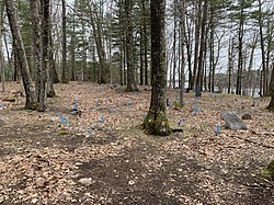
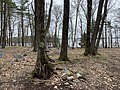
There are around 160 burials, most in unmarked graves. Dozens of blue plastic markers denote what are believed to be burials. The Mann family plot is surrounded by barbed wire, outside of which members of at least ten other families are buried.
200:
306:
311:
301:
316:
296:
189:
Residents and descendants of those interred in the cemetery demanded that L.L. Bean rebuild the track to re-establish public access to the cemetery.
206:
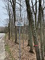
This formerly private access road was opened to the public in 2018. It is approximately 0.6 miles to the cemetery from Lower Flying Point Road
255:
87:
224:
80:
212:
260:
277:
172:
64:
290:
281:
175:, United States. It was established around 1750 and was closed to burials in 1922.
155:
160:
102:
89:
28:
183:
256:"L.L. Bean in dispute over access road to old cemetery in Freeport"
307:
1750 establishments in the
Province of Massachusetts Bay
33:
The blue markers denote what are believed to be burials
154:
143:
135:
127:
119:
79:
71:
57:
47:
42:
21:
8:
312:Buildings and structures in Freeport, Maine
302:Protected areas of Cumberland County, Maine
317:Cemeteries established in the 18th century
18:
16:Cemetery in Cumberland County, Maine, US
241:
230:The entrance on Lower Flying Point Road
196:
297:Cemeteries in Cumberland County, Maine
251:
249:
247:
245:
7:
171:is an historic cemetery located in
14:
223:
211:
199:
27:
144:
1:
182:A dispute arose in 2016 with
62:Off Lower Flying Point Road
53:(closed to burials in 1922)
333:
218:The known burial locations
131:Mann Cemetery Association
38:
26:
139:0.5 acres (0.20 ha)
261:Portland Press Herald
103:43.83333°N 70.04972°W
108:43.83333; -70.04972
99: /
166:
165:
324:
265:
253:
227:
215:
203:
146:
114:
113:
111:
110:
109:
104:
100:
97:
96:
95:
92:
31:
19:
332:
331:
327:
326:
325:
323:
322:
321:
287:
286:
274:
269:
268:
264:, July 30, 2016
254:
243:
238:
231:
228:
219:
216:
207:
204:
195:
173:Freeport, Maine
115:
107:
105:
101:
98:
93:
90:
88:
86:
85:
67:
65:Freeport, Maine
63:
52:
34:
17:
12:
11:
5:
330:
328:
320:
319:
314:
309:
304:
299:
289:
288:
285:
284:
273:
272:External links
270:
267:
266:
240:
239:
237:
234:
233:
232:
229:
222:
220:
217:
210:
208:
205:
198:
194:
191:
164:
163:
158:
152:
151:
148:
141:
140:
137:
133:
132:
129:
125:
124:
121:
117:
116:
83:
77:
76:
73:
69:
68:
61:
59:
55:
54:
49:
45:
44:
40:
39:
36:
35:
32:
24:
23:
15:
13:
10:
9:
6:
4:
3:
2:
329:
318:
315:
313:
310:
308:
305:
303:
300:
298:
295:
294:
292:
283:
279:
278:Mann Cemetery
276:
275:
271:
263:
262:
257:
252:
250:
248:
246:
242:
235:
226:
221:
214:
209:
202:
197:
192:
190:
187:
185:
180:
176:
174:
170:
169:Mann Cemetery
162:
161:Mann Cemetery
159:
157:
153:
149:
142:
138:
134:
130:
126:
122:
118:
112:
84:
82:
78:
75:United States
74:
70:
66:
60:
56:
50:
46:
41:
37:
30:
25:
22:Mann Cemetery
20:
282:Find A Grave
259:
188:
181:
177:
168:
167:
156:Find a Grave
106: /
81:Coordinates
48:Established
291:Categories
236:References
94:70°02′59″W
91:43°50′00″N
147:of graves
184:L.L.Bean
150:est. 160
128:Owned by
58:Location
193:Gallery
123:Private
72:Country
51:c. 1750
43:Details
136:Size
120:Type
280:at
145:No.
293::
258:-
244:^
Text is available under the Creative Commons Attribution-ShareAlike License. Additional terms may apply.