247:
1066:
33:
1207:
232:
690:
329:
680:
217:
1020:
621:, which mean 'old woman' and 'peak' or 'summit', respectively. The legend goes that two groups of people were each living on the summit of a hill, one of them named Sau Raha (now Soraha) and the other Sau Lor (now Saulidun). The two groups were engaged separately in their own daily activities, but each was accompanied by one of two
1078:
77:, is a useful starting point for translations, but translators must revise errors as necessary and confirm that the translation is accurate, rather than simply copy-pasting machine-translated text into the English Knowledge (XXG).
939:
528:
457:
63:
1110:
895:
480:
439:
575:, located in the central part of the country. It has a population of 45,541 (Census 2010) and an area of 1,783.3 km. The capital of the municipality is also named
1045:
969:
416:
1103:
80:
Do not translate text that appears unreliable or low-quality. If possible, verify the text with references provided in the foreign-language article.
993:
88:
946:
1231:
1096:
289:
354:
145:
918:
660:
to the west. It reaches both the south and north coasts of the island, and is only one of two municipalities to do so (the other is
1024:
1226:
833:
710:
365:
101:
Content in this edit is translated from the existing German
Knowledge (XXG) article at ]; see its history for attribution.
1056:
782:, later to become the nation's first president. He was born in the village of Laleia (19 km East of Manatuto town).
1119:
734:
722:
580:
568:
385:
375:
169:
149:
137:
740:
231:
1175:
764:
728:
380:
110:
716:
370:
321:
96:
117:
1206:
516:
1170:
1155:
661:
246:
1196:
1185:
1150:
985:
649:
645:
216:
1165:
1145:
1135:
760:
641:
552:
390:
341:
188:
1065:
1130:
653:
496:
45:
1160:
914:
657:
92:
1082:
779:
634:
968:[Manatuto Municipality: Municipal Strategic Development Plan] (Report) (in Tetum).
665:
599:
965:
756:
596:
560:
203:
689:
1220:
829:
633:
The borders of the municipality of
Manatuto are identical to those of the council of
509:
1040:
17:
844:
1070:
610:
1088:
804:
664:
in the far east), and has the most geographical diversity. To the north is the
572:
492:
334:
268:
841:
Placenames
Australia: Newsletter of the Australian National Placenames Survey
304:
291:
679:
669:
487:
1019:
747:
The administrative posts are divided into 29 sucos ("villages") in total.
576:
504:
346:
141:
1190:
99:
to the source of your translation. A model attribution edit summary is
945:(Report). District Administrator, Manatuto. April 2002. Archived from
706:
The municipality's administrative posts (formerly sub-districts) are:
1140:
767:
622:
770:, which is designated as a "national language" by the constitution.
688:
678:
763:), a large part of the population of the municipality speaks the
74:
1092:
966:
Munisipio
Manatuto: Planu Estartejiku Desenvolvimentu Munisipal
26:
1032:
595:
has been said to be a
Portuguese approximation of the local
869:
539:
1036:– official site (in Tetum with some content in English)
1054:
755:
In addition to the official languages of East Timor (
805:"Sub-national HDI - Area Database - Global Data Lab"
70:
534:
515:
503:
486:
476:
468:
463:
453:
445:
435:
427:
422:
412:
404:
399:
352:
340:
320:
160:
66:
a machine-translated version of the German article.
913:. Lanham, Maryland: Scarecrow Press. p. 124.
180:
972:/ Administration of Manatuto Municipality. 2015
778:The municipality is known as the birthplace of
640:The municipality borders the municipalities of
95:accompanying your translation by providing an
57:Click for important translation instructions.
44:expand this article with text translated from
1104:
970:Ministry of State Administration (East Timor)
8:
609:According to another source, the word is a
195:
1111:
1097:
1089:
157:
1061:
796:
533:
514:
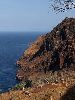
502:
485:
462:
421:
408:1,783.3 km (688.5 sq mi)
398:
339:
319:
284:
243:
225:
213:
175:
475:
467:
452:
444:
434:
426:
411:
403:
351:
275:
107:{{Translated|de|Manatuto (Gemeinde)}}
7:
988:[Manatuto District Profile]
911:Historical Dictionary of East Timor
898:. Timor-Leste Ministry of Finance.
25:
999:from the original on 3 March 2014
1205:
1076:
1064:
1046:Ministry of State Administration
1018:
872:[Profile: 2. Toponymy].
683:Administrative posts of Manatuto
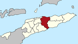
327:
245:
230:
215:
31:
606:, which means 'pecking birds'.
834:"The placenames of East Timor"
105:You may also add the template
1:
1232:Municipalities of East Timor
1120:Municipalities of East Timor
579:. It is the least populated
150:Manatuto Administrative Post
992:(Report) (in Tetum). 2012.
118:Knowledge (XXG):Translation
1248:
765:Malayo-Polynesian language
170:Municipality of East Timor
155:Municipality of East Timor
136:This article is about the
135:
131:Municipality of East Timor
69:Machine translation, like
1203:
1126:
1050:(in Portuguese and Tetum)
940:Manatuto District Profile
909:Gunn, Geoffrey C (2011).
285:
276:
244:
226:
214:
176:
167:
46:the corresponding article
986:Perfil Distritu Manatuto
571:(formerly districts) of
464:Households (2015 census)
1025:Manatuto (Municipality)
896:"Manatuto Suco Reports"
564:
454: • Rank
196:
116:For more guidance, see
1044:– information page on
870:"Perfil: 2. Toponímia"
694:
684:
668:, to the south is the
556:
181:
1227:Manatuto Municipality
1041:Manatuto Municipality
1033:Manatuto Municipality
1027:at Wikimedia Commons
874:Manatuto Municipality
843:: 6–7. Archived from
809:hdi.globaldatalab.org
692:
682:
625:, who were brothers.
540:Manatuto Municipality
449:26/km (68/sq mi)
89:copyright attribution
702:Administrative posts
637:with the same name.
446: • Density
355:Administrative posts
140:. For the city, see
850:on 14 February 2017
613:of the Tetum words
301: /
146:administrative post
18:Manatuto (district)
695:
693:Cities of Manatuto
685:
565:Munisípiu Manatutu
557:Município Manatuto
469: • Total
428: • Total
405: • Total
221:Cliffs at Manatuto
197:Munisípiu Manatutu
182:Município Manatuto
97:interlanguage link
1214:
1213:
1023:Media related to
711:Barique-Natarbora
699:
698:
546:
545:
477: • Rank
436: • Rank
413: • Rank
366:Barique-Natarbora
305:8.700°S 125.917°E
129:
128:
58:
54:
16:(Redirected from
1239:
1209:
1113:
1106:
1099:
1090:
1081:
1080:
1079:
1069:
1068:
1060:
1051:
1043:
1035:
1022:
1008:
1006:
1004:
998:
991:
981:
979:
977:
961:
959:
957:
952:on 28 March 2009
951:
944:
925:
924:
906:
900:
899:
892:
886:
885:
883:
881:
866:
860:
859:
857:
855:
849:
838:
826:
820:
819:
817:
815:
801:
675:
674:
648:to the east and
635:Portuguese Timor
567:) is one of the
542:
526:
357:
333:
331:
330:
316:
315:
313:
312:
311:
306:
302:
299:
298:
297:
294:
266:
264:
256:
254:
249:
234:
219:
207:
199:
192:
184:
158:
108:
102:
75:Google Translate
56:
52:
35:
34:
27:
21:
1247:
1246:
1242:
1241:
1240:
1238:
1237:
1236:
1217:
1216:
1215:
1210:
1201:
1122:
1117:
1087:
1077:
1075:
1063:
1055:
1049:
1039:
1031:
1016:
1011:
1002:
1000:
996:
989:
984:
975:
973:
964:
955:
953:
949:
942:
938:
934:
929:
928:
921:
908:
907:
903:
894:
893:
889:
879:
877:
868:
867:
863:
853:
851:
847:
836:
828:
827:
823:
813:
811:
803:
802:
798:
793:
788:
776:
753:
704:
666:Strait of Wetar
631:
600:Galoli language
589:
583:of East Timor.
538:
524:
523:
395:
353:
328:
326:
310:-8.700; 125.917
309:
307:
303:
300:
295:
292:
290:
288:
287:
281:
280:
272:
262:
261:
252:
251:
240:
239:
238:
237:
222:
210:
201:
186:
172:
163:
156:
153:
132:
125:
124:
123:
106:
100:
59:
36:
32:
23:
22:
15:
12:
11:
5:
1245:
1243:
1235:
1234:
1229:
1219:
1218:
1212:
1211:
1204:
1202:
1200:
1199:
1194:
1188:
1183:
1178:
1173:
1168:
1163:
1158:
1153:
1148:
1143:
1138:
1133:
1127:
1124:
1123:
1118:
1116:
1115:
1108:
1101:
1093:
1086:
1085:
1073:
1053:
1052:
1037:
1015:
1014:External links
1012:
1010:
1009:
982:
962:
935:
933:
930:
927:
926:
919:
901:
887:
861:
830:Hull, Geoffrey
821:
795:
794:
792:
789:
787:
784:
775:
774:Notable people
772:
752:
749:
745:
744:
738:
732:
726:
720:
714:
703:
700:
697:
696:
686:
630:
627:
588:
585:
569:municipalities
544:
543:
536:
532:
531:
520:
513:
512:
507:
501:
500:
490:
484:
483:
478:
474:
473:
470:
466:
465:
461:
460:
455:
451:
450:
447:
443:
442:
437:
433:
432:
429:
425:
424:
420:
419:
414:
410:
409:
406:
402:
401:
397:
396:
394:
393:
388:
383:
378:
373:
368:
362:
358:
350:
349:
344:
338:
337:
324:
318:
317:
283:
282:
278:
277:
274:
273:
250:
242:
241:
235:
229:
228:
227:
224:
223:
220:
212:
211:
209:
208:
193:
177:
174:
173:
168:
165:
164:
161:
154:
130:
127:
126:
122:
121:
114:
103:
81:
78:
67:
60:
41:
40:
39:
37:
30:
24:
14:
13:
10:
9:
6:
4:
3:
2:
1244:
1233:
1230:
1228:
1225:
1224:
1222:
1208:
1198:
1195:
1192:
1189:
1187:
1184:
1182:
1179:
1177:
1174:
1172:
1169:
1167:
1164:
1162:
1159:
1157:
1154:
1152:
1149:
1147:
1144:
1142:
1139:
1137:
1134:
1132:
1129:
1128:
1125:
1121:
1114:
1109:
1107:
1102:
1100:
1095:
1094:
1091:
1084:
1074:
1072:
1067:
1062:
1058:
1047:
1042:
1038:
1034:
1030:
1029:
1028:
1026:
1021:
1013:
995:
987:
983:
971:
967:
963:
948:
941:
937:
936:
931:
922:
920:9780810867543
916:
912:
905:
902:
897:
891:
888:
875:
871:
865:
862:
846:
842:
835:
832:(June 2006).
831:
825:
822:
810:
806:
800:
797:
790:
785:
783:
781:
780:Xanana Gusmão
773:
771:
769:
766:
762:
758:
750:
748:
742:
739:
737:(pop. 11,500)
736:
733:
730:
727:
725:(pop. 10,100)
724:
721:
718:
715:
712:
709:
708:
707:
701:
691:
687:
681:
677:
676:
673:
671:
667:
663:
659:
655:
651:
647:
643:
638:
636:
628:
626:
624:
620:
616:
612:
607:
605:
601:
598:
594:
586:
584:
582:
578:
574:
570:
566:
562:
558:
554:
550:
541:
537:
530:
521:
518:
511:
508:
506:
505:ISO 3166 code
498:
494:
491:
489:
482:
479:
471:
459:
456:
448:
441:
438:
430:
418:
415:
407:
392:
389:
387:
384:
382:
379:
377:
374:
372:
369:
367:
364:
363:
361:
359:
356:
348:
345:
343:
336:
325:
323:
314:
286:Coordinates:
279:OpenStreetMap
271:
270:
259:
248:
233:
218:
205:
198:
194:
190:
183:
179:
178:
171:
166:
159:
151:
147:
143:
139:
134:
119:
115:
112:
104:
98:
94:
90:
86:
82:
79:
76:
72:
68:
65:
62:
61:
55:
49:
47:
42:You can help
38:
29:
28:
19:
1180:
1017:
1001:. Retrieved
974:. Retrieved
954:. Retrieved
947:the original
932:Bibliography
910:
904:
890:
878:. Retrieved
873:
864:
852:. Retrieved
845:the original
840:
824:
814:13 September
812:. Retrieved
808:
799:
777:
754:
751:Demographics
746:
743:(pop. 2,950)
731:(pop. 3,200)
719:(pop. 6,400)
713:(pop. 4,900)
705:
639:
632:
618:
614:
608:
603:
592:
590:
581:municipality
548:
547:
360:
267:
257:
236:Official map
138:municipality
133:
93:edit summary
84:
51:
43:
956:27 February
611:portmanteau
308: /
53:(July 2011)
1221:Categories
876:(in Tetum)
786:References
761:Portuguese
573:East Timor
553:Portuguese
423:Population
335:East Timor
269:East Timor
189:Portuguese
144:. For the
1156:Cova Lima
1083:Geography
670:Timor Sea
629:Geography
597:Tetum and
591:The word
587:Etymology
493:UTC+09:00
488:Time zone
260:in
258:Manatuto
111:talk page
48:in German
1197:Viqueque
1186:Manufahi
1181:Manatuto
1151:Bobonaro
994:Archived
735:Manatuto
723:Laclubar
650:Manufahi
646:Viqueque
604:Manatutu
593:Manatuto
577:Manatuto
549:Manatuto
386:Manatuto
376:Laclubar
347:Manatuto
296:125°55′E
162:Manatuto
142:Manatuto
87:provide
1191:Oecusse
1176:Liquiçá
1057:Portals
1003:18 July
976:18 July
880:18 July
741:Soibada
535:Website
391:Soibada
342:Capital
322:Country
109:to the
91:in the
50:.
1171:Lautém
1166:Ermera
1146:Baucau
1141:Atauro
1136:Ainaro
917:
854:4 June
768:Galoli
729:Laleia
662:Lautém
656:, and
642:Baucau
623:Liurai
525:medium
519:(2017)
431:46,619
381:Laleia
332:
293:8°42′S
265:
263:
255:
253:
200:
185:
148:, see
1193:(SAR)
1131:Aileu
1048:site
997:(PDF)
990:(PDF)
950:(PDF)
943:(PDF)
848:(PDF)
837:(PDF)
791:Notes
757:Tetum
717:Laclo
654:Aileu
602:word
561:Tetum
522:0.614
510:TL-MT
472:7,467
371:Laclo
204:Tetum
71:DeepL
1161:Dili
1071:Asia
1005:2022
978:2022
958:2022
915:ISBN
882:2022
856:2018
816:2018
759:and
658:Dili
644:and
619:tutu
617:and
615:Mana
481:12th
458:13th
440:13th
400:Area
85:must
83:You
64:View
529:5th
517:HDI
497:TLT
417:2nd
73:or
1223::
839:.
807:.
672:.
652:,
563::
559:,
555::
527:·
1112:e
1105:t
1098:v
1059::
1007:.
980:.
960:.
923:.
884:.
858:.
818:.
551:(
499:)
495:(
206:)
202:(
191:)
187:(
152:.
120:.
113:.
20:)
Text is available under the Creative Commons Attribution-ShareAlike License. Additional terms may apply.