263:
47:
31:
860:
555:
423:
116:
54:
270:
09 fokontany (villages) are part of this municipality: Manantenina Haut, Manantenina Bas, Ambalateza, Ankarefo, Ampasimasay, Esama, Ankaromanihy, Manambato and
Antanintsara. The population of the commune was estimated to be approximately 19,000 in 2001 commune
278:
Primary and junior level secondary education are available in town. The majority 50% of the population works in fishing. 35% are farmers, while an additional 10% receives their livelihood from raising livestock. The most important crop is
389:
901:
925:
78:
920:
46:
340:
245:
411:
894:
687:
442:
241:
824:
887:
336:
222:
140:
30:
450:
803:
788:
723:
677:
381:
324:
128:
262:
256:
708:
524:
494:
404:
252:
469:
582:
563:
361:
226:
145:
539:
871:
783:
304:
195:
703:
647:
554:
859:
397:
382:
Projet de réhabilitation de la RN12A entre
Ebakika PK 44+850 et Manambondro PK 165+231
325:
Projet de réhabilitation de la RN12A entre
Ebakika PK 44+850 et Manambondro PK 165+231
914:
758:
529:
459:
733:
718:
587:
577:
284:
237:
230:
652:
607:
597:
514:
763:
713:
698:
592:
432:
422:
218:
121:
839:
826:
93:
80:
798:
768:
753:
738:
693:
667:
657:
622:
617:
572:
534:
186:
357:
793:
748:
662:
632:
627:
602:
778:
743:
642:
637:
612:
544:
519:
509:
489:
280:
728:
504:
499:
479:
464:
272:
867:
484:
474:
428:
261:
133:
288:
191:
393:
291:. Services provide employment for 5% of the population.
875:
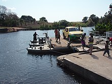
255:. In its south the municipality is also crossed by the
266:
Madagascar national road 12a ferry over the
Ankaramany
676:
562:
449:
202:
185:
177:
172:
164:
156:
151:
139:
127:
109:
21:
895:
405:
307:, a bauxit deposit that is not yet exploited.
8:
902:
888:
412:
398:
390:
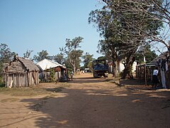
251:Manantenina lies at southern banks of the
18:
317:
201:
184:
171:
163:
150:
108:
73:
39:
27:
352:
350:
348:
283:, while other important products are
176:
155:
138:
126:
7:
856:
854:
236:It is situated at the coast of the
53:
874:. You can help Knowledge (XXG) by
14:
160:421 km (163 sq mi)
858:
553:
421:
341:Shuttle Radar Topography Mission
114:
52:
45:
29:
1:
926:Anosy Region geography stubs
217:is a rural municipality in
942:
853:
16:Place in Anosy, Madagascar
921:Populated places in Anosy
812:
688:Fort Dauphin (Taolagnaro)
551:
443:Fort Dauphin (Taolagnaro)
439:
74:
40:
28:
814:3 districts; 62 communes
870:location article is a
433:Republic of Madagascar
267:
168:16 m (52 ft)
66:Location in Madagascar
265:
229:, which is a part of
221:. It belongs to the
836: /
335:Estimated based on
246:Route nationale 12a
240:at 107 km North of
90: /
362:Cornell University
268:
178: • Total
157: • Total
883:
882:
840:24.283°S 47.317°E
819:
818:
358:"ILO census data"
212:
211:
94:24.283°S 47.317°E
933:
904:
897:
890:
862:
855:
851:
850:
848:
847:
846:
841:
837:
834:
833:
832:
829:
784:Mandromodromotra
557:
427:Communes in the
426:
425:
414:
407:
400:
391:
384:
379:
373:
372:
370:
369:
354:
343:
333:
327:
322:
305:Manantenina mine
257:Ankaramany river
120:
118:
117:
105:
104:
102:
101:
100:
95:
91:
88:
87:
86:
83:
56:
55:
49:
33:
19:
941:
940:
936:
935:
934:
932:
931:
930:
911:
910:
909:
908:
845:-24.283; 47.317
844:
842:
838:
835:
830:
827:
825:
823:
822:
820:
815:
808:
704:Ampasy Nahampoa
672:
558:
549:
445:
435:
420:
418:
388:
387:
380:
376:
367:
365:
356:
355:
346:
334:
330:
323:
319:
314:
300:
294:
244:on the unpaved
208:
115:
113:
99:-24.283; 47.317
98:
96:
92:
89:
84:
81:
79:
77:
76:
70:
69:
68:
67:
64:
63:
62:
61:
57:
36:
24:
17:
12:
11:
5:
939:
937:
929:
928:
923:
913:
912:
907:
906:
899:
892:
884:
881:
880:
863:
817:
816:
813:
810:
809:
807:
806:
801:
796:
791:
786:
781:
776:
771:
766:
761:
756:
751:
746:
741:
736:
731:
726:
721:
716:
711:
706:
701:
696:
691:
683:
681:
674:
673:
671:
670:
665:
660:
655:
650:
645:
640:
635:
630:
625:
620:
615:
610:
605:
600:
595:
590:
585:
580:
575:
569:
567:
560:
559:
552:
550:
548:
547:
542:
537:
532:
527:
522:
517:
512:
507:
502:
497:
492:
487:
482:
477:
472:
467:
462:
456:
454:
447:
446:
440:
437:
436:
419:
417:
416:
409:
402:
394:
386:
385:
374:
344:
328:
316:
315:
313:
310:
309:
308:
299:
296:
285:sweet potatoes
210:
209:
206:
204:
200:
199:
189:
183:
182:
179:
175:
174:
170:
169:
166:
162:
161:
158:
154:
153:
149:
148:
143:
137:
136:
131:
125:
124:
111:
107:
106:
72:
71:
65:
59:
58:
51:
50:
44:
43:
42:
41:
38:
37:
34:
26:
25:
22:
15:
13:
10:
9:
6:
4:
3:
2:
938:
927:
924:
922:
919:
918:
916:
905:
900:
898:
893:
891:
886:
885:
879:
877:
873:
869:
864:
861:
857:
852:
849:
811:
805:
802:
800:
797:
795:
792:
790:
787:
785:
782:
780:
777:
775:
772:
770:
767:
765:
762:
760:
759:Isaka-Ivondro
757:
755:
752:
750:
747:
745:
742:
740:
737:
735:
732:
730:
727:
725:
722:
720:
717:
715:
712:
710:
707:
705:
702:
700:
697:
695:
692:
690:
689:
685:
684:
682:
679:
675:
669:
666:
664:
661:
659:
656:
654:
651:
649:
646:
644:
641:
639:
636:
634:
631:
629:
626:
624:
621:
619:
616:
614:
611:
609:
606:
604:
601:
599:
596:
594:
591:
589:
586:
584:
581:
579:
576:
574:
571:
570:
568:
565:
561:
556:
546:
543:
541:
538:
536:
533:
531:
530:Tanandava Sud
528:
526:
523:
521:
518:
516:
513:
511:
508:
506:
503:
501:
498:
496:
493:
491:
488:
486:
483:
481:
478:
476:
473:
471:
468:
466:
463:
461:
460:Amboasary Sud
458:
457:
455:
452:
451:Amboasary Sud
448:
444:
438:
434:
430:
424:
415:
410:
408:
403:
401:
396:
395:
392:
383:
378:
375:
363:
359:
353:
351:
349:
345:
342:
338:
332:
329:
326:
321:
318:
311:
306:
302:
301:
297:
295:
292:
290:
286:
282:
276:
274:
264:
260:
258:
254:
253:Soavary river
249:
247:
243:
239:
234:
232:
228:
224:
220:
216:
205:
197:
193:
190:
188:
180:
167:
159:
147:
144:
142:
135:
132:
130:
123:
112:
103:
75:Coordinates:
48:
32:
20:
876:expanding it
868:Anosy Region
865:
821:
773:
734:Enakara-Haut
719:Andranombory
686:
588:Andriandampy
578:Ambatomivary
470:Berano Ville
429:Anosy Region
377:
366:. Retrieved
331:
320:
293:
277:
269:
250:
242:Fort-Dauphin
238:Indian Ocean
235:
231:Anosy Region
214:
213:
843: /
774:Manantenina
653:Mahasoa Est
608:Benato-Toby
598:Beapombo II
515:Marotsiraka
215:Manantenina
203:Postal code
97: /
60:Manantenina
35:Manantenina
23:Manantenina
915:Categories
804:Soanierana
789:Ranomafana
764:Mahatalaky
724:Ankaramena
714:Analapatsy
699:Ampasimena
680:(24) - 614
678:Taolagnaro
593:Beapombo I
566:(20) - 613
540:Tomboarivo
453:(18) - 603
368:2008-05-04
339:data from
312:References
219:Madagascar
173:Population
122:Madagascar
799:Sarasambo
769:Manambaro
754:Ifarantsa
739:Enaniliha
709:Analamary
694:Ambatoabo
668:Tsaraitso
658:Nagnarena
623:Ianabinda
618:Iaborotra
583:Analamary
573:Ambalasoa
535:Tranomaro
441:Capital:
227:Taolanaro
187:Time zone
165:Elevation
146:Taolanaro
794:Ranopiso
749:Iabakoho
663:Naninora
633:Isoanala
628:Ianakafy
603:Bekorobo
223:district
141:District
831:47°19′E
828:24°17′S
779:Mandiso
744:Fenoevo
643:Jangany
638:Ivahona
613:Betroka
564:Betroka
545:Tsivory
520:Sampona
510:Maromby
490:Ifotaka
431:of the
281:cassava
110:Country
85:47°19′E
82:24°17′S
729:Bevoay
648:Mahabo
525:Ranobe
505:Manevy
500:Mahaly
495:Mahabo
480:Elonty
465:Behara
364:. 2002
298:Mining
273:census
181:19,000
129:Region
119:
866:This
485:Esira
475:Ebelo
134:Anosy
872:stub
303:the
289:rice
287:and
192:UTC3
152:Area
337:DEM
225:of
207:614
196:EAT
917::
360:.
347:^
275:.
259:.
248:.
233:.
903:e
896:t
889:v
878:.
413:e
406:t
399:v
371:.
198:)
194:(
Text is available under the Creative Commons Attribution-ShareAlike License. Additional terms may apply.