116:
1569:
100:
1375:
1365:
374:
85:
1620:
75:
60:
1518:
123:
506:) characterized by warm summers and cold winters with heavy snowfall. The average annual temperature in Kanna is 10.7 °C. The average annual rainfall is 1195 mm with September as the wettest month. The temperatures are highest on average in August, at around 23.7 °C, and lowest in January, at around -1.7 °C.
1313:
town council of 8 members. Kanna, together with the city of
Fujioka and village of Ueno contributes two members to the Gunma Prefectural Assembly. In terms of national politics, the town is part of
1341:
Kanna has one public elementary school and one public middle school operated by the town government. The town has one public high school operated by the Gunma
Prefectural Board of Education.
1095:
Per
Japanese census data, the town's population has dropped precipitously from its 1950 peak, with the remaining population having the second oldest median age in Japan after
1486:
115:
1459:
1297:. Kamikawa village was elevated to town status in 1926 and renamed Manba town. On April 1, 2003, Manba and Nakasato merged, forming the town of Kanna.
1568:
147:
99:
1878:
1897:
421:
of 14.35 persons per km². The total area of the town is 114.6 square kilometres (44.2 sq mi). A footprint of Japan's first
1318:
294:
1558:
1619:
1536:
1492:
1465:
1278:
1081:
84:
1767:
1586:
499:
299:
1708:
1378:
1368:
191:
179:
1522:
1628:
1784:
1713:
1286:
402:
59:
74:
1902:
1745:
1845:
1828:
1816:
1596:
1294:
1290:
220:
203:
1551:
373:
270:
1687:
1314:
1267:
476:
438:
418:
336:
215:
1728:
1271:
1424:
1282:
1101:
1034:
482:
1855:
1804:
1777:
1755:
1682:
1572:
1447:
1281:
Prefecture on April 1, 1889 with the creation of the modern municipalities system after the
465:
449:
434:
406:
208:
1850:
1772:
1733:
1397:
360:
1865:
1667:
196:
1794:
1789:
1760:
1718:
1692:
1662:
1544:
1096:
487:
470:
455:
50:
1891:
1860:
1809:
1677:
1672:
1657:
1641:
1322:
1306:
913:
1799:
1750:
347:
1838:
460:
1723:
1310:
1257:
414:
162:
149:
261:
17:
1262:
1517:
1821:
1738:
1609:
1604:
1581:
422:
1636:
266:
1528:
513:
Climate data for Kanna (1991−2020 normals, extremes 1977−present)
410:
372:
311:
184:
1122:
1540:
1277:
Kamikawa village and
Nakasato village were established within
425:
was discovered in former
Nakasato village, now part of Kanna.
1099:(61.5% over the age or 65). The town is thus classified as a
1117:
433:
Kanna is located in the mountainous southwestern portion of
413:. As of 1 October 2020, the town had an estimated
1333:
The economy of Kanna is heavily dependent on agriculture.
1309:
form of government with a directly elected mayor and a
289:
90-6 Manba, Kanna-machi, Tano-gun, Gunma-ken 370-1592
1393:
Sazanamiiwa (The location of the dinosaur footprint)
1701:
1650:
1627:
1595:
1354:Kanna does not have any passenger railway service.
355:
342:
332:
305:
293:
285:
277:
260:
252:
244:
239:
231:
226:
214:
202:
190:
178:
32:
1419:
1417:
1285:. In 1896 Minamikanra District was united with
1260:, the area of present-day Kanna was part of the
392:
386:
38:
1552:
8:
1108:
1559:
1545:
1537:
1107:
509:
29:
1413:
1266:territory administered directly by the
327:
304:
292:
276:
259:
238:
225:
177:
142:
108:
96:
68:
56:
354:
341:
331:
284:
251:
243:
230:
213:
201:
189:
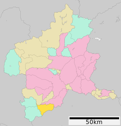
104:Location of Kanna in Gunma Prefecture
7:
235:114.6 km (44.2 sq mi)
1879:List of mergers in Gunma Prefecture
25:
1396:Ryūshōji (A temple famed for its
1618:
1567:
1516:
1373:
1363:
121:
114:
98:
83:
73:
58:
1403:Roadside Station Manba no Sato
1:
122:
1279:Minamikanra District, Gunma
986:Average precipitation days
772:Mean daily minimum °C (°F)
632:Mean daily maximum °C (°F)
393:
1919:
1079:
512:
445:Surrounding municipalities
1898:Towns in Gunma Prefecture
1876:
1616:
1579:
1135:—
1032:
985:
911:
841:
771:
701:
631:
561:
556:
553:
550:
547:
544:
541:
538:
535:
532:
529:
526:
523:
520:
517:
500:Humid continental climate
387:
367:
328:
323:
319:
143:
109:
97:
69:
57:
48:
39:
1487:
1460:
377:Kanna Koinobori Festival
36:
1425:"Kanna city population"
1379:National Route 462
1369:National Route 299
163:36.115917°N 138.91972°E
378:
1461:観測史上1~10位の値(年間を通じての値)
1390:Kanna Dinosaur Center
1109:Historical population
376:
256:14/km (37/sq mi)
1525:at Wikimedia Commons
562:Record high °C (°F)
253: • Density
168:36.115917; 138.91972
27:Town in Kantō, Japan
1110:
842:Record low °C (°F)
702:Daily mean °C (°F)
271:Japan Standard Time
159: /
1768:Kitagunma District
1488:気象庁 / 平年値(年・月ごとの値)
1448:Kanna climate data
1315:Gunma 4th district
1268:Tokugawa shogunate
477:Saitama Prefecture
439:Saitama Prefecture
419:population density
379:
337:Japanese white-eye
245: • Total
232: • Total
1885:
1884:
1709:Agatsuma District
1590:
1521:Media related to
1385:Local attractions
1283:Meiji Restoration
1249:
1248:
1087:
1086:
371:
370:
278:Phone number
64:Kanna town office
16:(Redirected from
1910:
1622:
1584:
1573:Gunma Prefecture
1571:
1561:
1554:
1547:
1538:
1533:
1529:Official Website
1520:
1504:
1503:
1501:
1499:
1483:
1477:
1476:
1474:
1472:
1456:
1450:
1445:
1439:
1438:
1436:
1435:
1421:
1377:
1376:
1367:
1366:
1124:
1119:
1111:
989:
510:
450:Gunma Prefecture
435:Gunma Prefecture
407:Gunma Prefecture
400:
399:
396:
390:
389:
315:
314:
312:Official website
174:
173:
171:
170:
169:
164:
160:
157:
156:
155:
152:
125:
124:
118:
102:
87:
77:
62:
43:
42:
41:
30:
21:
1918:
1917:
1913:
1912:
1911:
1909:
1908:
1907:
1888:
1887:
1886:
1881:
1872:
1714:Higashiagatsuma
1697:
1646:
1623:
1614:
1591:
1575:
1565:
1531:
1513:
1508:
1507:
1497:
1495:
1489:
1485:
1484:
1480:
1470:
1468:
1462:
1458:
1457:
1453:
1446:
1442:
1433:
1431:
1423:
1422:
1415:
1410:
1398:cherry blossoms
1387:
1374:
1364:
1360:
1352:
1347:
1339:
1331:
1303:
1272:Kōzuke Province
1254:
1093:
1088:
987:
980:
975:
970:
965:
960:
955:
950:
945:
940:
935:
930:
925:
920:
906:
901:
896:
891:
886:
881:
876:
871:
866:
861:
856:
851:
846:
836:
831:
826:
821:
816:
811:
806:
801:
796:
791:
786:
781:
776:
766:
761:
756:
751:
746:
741:
736:
731:
726:
721:
716:
711:
706:
696:
691:
686:
681:
676:
671:
666:
661:
656:
651:
646:
641:
636:
626:
621:
616:
611:
606:
601:
596:
591:
586:
581:
576:
571:
566:
496:
447:
431:
417:of 1,645 and a
397:
384:
361:Zelkova serrata
310:
309:
167:
165:
161:
158:
153:
150:
148:
146:
145:
139:
138:
137:
136:
133:
132:
131:
130:
126:
105:
93:
92:
91:
90:
81:
80:
65:
53:
44:
37:
35:
28:
23:
22:
15:
12:
11:
5:
1916:
1914:
1906:
1905:
1900:
1890:
1889:
1883:
1882:
1877:
1874:
1873:
1871:
1870:
1869:
1868:
1863:
1858:
1853:
1843:
1842:
1841:
1836:
1826:
1825:
1824:
1814:
1813:
1812:
1807:
1802:
1797:
1792:
1782:
1781:
1780:
1775:
1765:
1764:
1763:
1758:
1753:
1746:Kanra District
1743:
1742:
1741:
1736:
1731:
1726:
1721:
1716:
1705:
1703:
1699:
1698:
1696:
1695:
1690:
1685:
1680:
1675:
1670:
1665:
1660:
1654:
1652:
1648:
1647:
1645:
1644:
1639:
1633:
1631:
1629:Special cities
1625:
1624:
1617:
1615:
1613:
1612:
1607:
1601:
1599:
1593:
1592:
1580:
1577:
1576:
1566:
1564:
1563:
1556:
1549:
1541:
1535:
1534:
1526:
1512:
1511:External links
1509:
1506:
1505:
1478:
1451:
1440:
1429:citypopulation
1412:
1411:
1409:
1406:
1405:
1404:
1401:
1394:
1391:
1386:
1383:
1382:
1381:
1371:
1359:
1356:
1351:
1348:
1346:
1345:Transportation
1343:
1338:
1335:
1330:
1327:
1302:
1299:
1291:Tago Districts
1253:
1250:
1247:
1246:
1243:
1240:
1236:
1235:
1232:
1229:
1225:
1224:
1221:
1218:
1214:
1213:
1210:
1207:
1203:
1202:
1199:
1196:
1192:
1191:
1188:
1185:
1181:
1180:
1177:
1174:
1170:
1169:
1166:
1163:
1159:
1158:
1155:
1152:
1148:
1147:
1144:
1141:
1137:
1136:
1133:
1130:
1126:
1125:
1120:
1115:
1102:genkai shūraku
1097:Nanmoku, Gunma
1092:
1089:
1085:
1084:
1077:
1076:
1073:
1070:
1067:
1064:
1061:
1058:
1055:
1052:
1049:
1046:
1043:
1040:
1037:
1035:sunshine hours
1030:
1029:
1026:
1023:
1020:
1017:
1014:
1011:
1008:
1005:
1002:
999:
996:
993:
990:
983:
982:
977:
972:
967:
962:
957:
952:
947:
942:
937:
932:
927:
922:
917:
909:
908:
903:
898:
893:
888:
883:
878:
873:
868:
863:
858:
853:
848:
843:
839:
838:
833:
828:
823:
818:
813:
808:
803:
798:
793:
788:
783:
778:
773:
769:
768:
763:
758:
753:
748:
743:
738:
733:
728:
723:
718:
713:
708:
703:
699:
698:
693:
688:
683:
678:
673:
668:
663:
658:
653:
648:
643:
638:
633:
629:
628:
623:
618:
613:
608:
603:
598:
593:
588:
583:
578:
573:
568:
563:
559:
558:
555:
552:
549:
546:
543:
540:
537:
534:
531:
528:
525:
522:
519:
515:
514:
508:
495:
492:
491:
490:
485:
474:
473:
468:
463:
458:
446:
443:
441:to the south.
437:, bordered by
430:
427:
369:
368:
365:
364:
357:
353:
352:
344:
340:
339:
334:
330:
329:
326:
325:
321:
320:
317:
316:
307:
303:
302:
297:
291:
290:
287:
283:
282:
279:
275:
274:
264:
258:
257:
254:
250:
249:
246:
242:
241:
237:
236:
233:
229:
228:
224:
223:
218:
212:
211:
206:
200:
199:
194:
188:
187:
182:
176:
175:
141:
140:
134:
128:
127:
120:
119:
113:
112:
111:
110:
107:
106:
103:
95:
94:
88:
82:
78:
72:
71:
70:
67:
66:
63:
55:
54:
49:
46:
45:
33:
26:
24:
14:
13:
10:
9:
6:
4:
3:
2:
1915:
1904:
1901:
1899:
1896:
1895:
1893:
1880:
1875:
1867:
1864:
1862:
1859:
1857:
1854:
1852:
1849:
1848:
1847:
1846:Tone District
1844:
1840:
1837:
1835:
1832:
1831:
1830:
1829:Tano District
1827:
1823:
1820:
1819:
1818:
1817:Sawa District
1815:
1811:
1808:
1806:
1803:
1801:
1798:
1796:
1793:
1791:
1788:
1787:
1786:
1783:
1779:
1776:
1774:
1771:
1770:
1769:
1766:
1762:
1759:
1757:
1754:
1752:
1749:
1748:
1747:
1744:
1740:
1737:
1735:
1732:
1730:
1727:
1725:
1722:
1720:
1717:
1715:
1712:
1711:
1710:
1707:
1706:
1704:
1700:
1694:
1691:
1689:
1686:
1684:
1681:
1679:
1676:
1674:
1671:
1669:
1666:
1664:
1661:
1659:
1656:
1655:
1653:
1649:
1643:
1640:
1638:
1635:
1634:
1632:
1630:
1626:
1621:
1611:
1608:
1606:
1603:
1602:
1600:
1598:
1594:
1588:
1583:
1578:
1574:
1570:
1562:
1557:
1555:
1550:
1548:
1543:
1542:
1539:
1532:(in Japanese)
1530:
1527:
1524:
1519:
1515:
1514:
1510:
1494:
1490:
1482:
1479:
1467:
1463:
1455:
1452:
1449:
1444:
1441:
1430:
1426:
1420:
1418:
1414:
1407:
1402:
1399:
1395:
1392:
1389:
1388:
1384:
1380:
1372:
1370:
1362:
1361:
1357:
1355:
1349:
1344:
1342:
1336:
1334:
1328:
1326:
1324:
1323:Diet of Japan
1320:
1316:
1312:
1308:
1307:mayor-council
1300:
1298:
1296:
1295:Tano District
1292:
1288:
1284:
1280:
1275:
1273:
1269:
1265:
1264:
1259:
1251:
1244:
1241:
1238:
1237:
1233:
1230:
1227:
1226:
1222:
1219:
1216:
1215:
1211:
1208:
1205:
1204:
1200:
1197:
1194:
1193:
1189:
1186:
1183:
1182:
1178:
1175:
1172:
1171:
1167:
1164:
1161:
1160:
1156:
1153:
1150:
1149:
1145:
1142:
1139:
1138:
1134:
1131:
1128:
1127:
1121:
1116:
1113:
1112:
1106:
1104:
1103:
1098:
1090:
1083:
1078:
1074:
1071:
1068:
1065:
1062:
1059:
1056:
1053:
1050:
1047:
1044:
1041:
1038:
1036:
1033:Mean monthly
1031:
1027:
1024:
1021:
1018:
1015:
1012:
1009:
1006:
1003:
1000:
997:
994:
991:
984:
978:
973:
968:
963:
958:
953:
948:
943:
938:
933:
928:
923:
918:
915:
914:precipitation
910:
904:
899:
894:
889:
884:
879:
874:
869:
864:
859:
854:
849:
844:
840:
834:
829:
824:
819:
814:
809:
804:
799:
794:
789:
784:
779:
774:
770:
764:
759:
754:
749:
744:
739:
734:
729:
724:
719:
714:
709:
704:
700:
694:
689:
684:
679:
674:
669:
664:
659:
654:
649:
644:
639:
634:
630:
624:
619:
614:
609:
604:
599:
594:
589:
584:
579:
574:
569:
564:
560:
516:
511:
507:
505:
501:
493:
489:
486:
484:
481:
480:
479:
478:
472:
469:
467:
464:
462:
459:
457:
454:
453:
452:
451:
444:
442:
440:
436:
428:
426:
424:
420:
416:
412:
408:
404:
395:
383:
375:
366:
363:
362:
358:
351:
349:
345:
338:
335:
322:
318:
313:
308:
301:
298:
296:
288:
280:
272:
268:
265:
263:
255:
247:
234:
222:
219:
217:
210:
207:
205:
198:
195:
193:
186:
183:
181:
172:
144:Coordinates:
117:
101:
86:
76:
61:
52:
47:
31:
19:
1903:Kanna, Gunma
1833:
1785:Ōra District
1523:Kanna, Gunma
1498:February 26,
1496:. Retrieved
1481:
1471:February 26,
1469:. Retrieved
1454:
1443:
1432:. Retrieved
1428:
1353:
1340:
1332:
1305:Kanna has a
1304:
1276:
1261:
1255:
1100:
1094:
1091:Demographics
916:mm (inches)
503:
498:Kanna has a
497:
475:
448:
432:
381:
380:
359:
348:Rhododendron
346:
281:0274-57-2111
18:Manba, Gunma
1688:Tatebayashi
1597:Core cities
1319:lower house
1256:During the
405:located in
394:Kanna-machi
166: /
154:138°55′11″E
151:36°6′57.3″N
1892:Categories
1724:Naganohara
1434:2022-09-26
1408:References
1311:unicameral
1301:Government
1293:to create
1258:Edo period
988:(≥ 1.0 mm)
415:population
240:Population
204:Prefecture
1856:Katashina
1756:Shimonita
1702:Districts
1683:Shibukawa
1337:Education
466:Shimonita
429:Geography
423:dinosaurs
350:dilatatum
262:Time zone
1851:Minakami
1822:Tamamura
1773:Yoshioka
1739:Tsumagoi
1734:Takayama
1729:Nakanojō
1610:Takasaki
1605:Maebashi
1582:Maebashi
1080:Source:
1075:2,134.8
981:(49.22)
912:Average
627:(101.7)
597:(101.7)
502:(Köppen
483:Chichibu
216:District
1795:Itakura
1790:Chiyoda
1761:Nanmoku
1719:Kusatsu
1693:Tomioka
1663:Fujioka
1637:Isesaki
1587:capital
1358:Highway
1350:Railway
1329:Economy
1321:of the
1317:of the
1252:History
979:1,250.2
976:(0.88)
971:(1.47)
966:(6.83)
961:(8.83)
956:(7.12)
951:(7.15)
946:(5.65)
941:(3.82)
936:(2.92)
931:(2.32)
926:(0.97)
921:(1.26)
907:(11.1)
902:(17.2)
897:(23.5)
892:(31.5)
887:(42.8)
882:(52.5)
877:(53.8)
872:(42.8)
867:(32.0)
862:(23.9)
857:(15.8)
852:(11.1)
847:(13.5)
837:(45.3)
832:(28.4)
827:(37.2)
822:(50.0)
817:(61.3)
812:(68.2)
807:(66.7)
802:(59.2)
797:(50.2)
792:(40.3)
787:(31.5)
782:(25.7)
777:(24.6)
767:(53.6)
762:(36.7)
757:(45.7)
752:(57.0)
747:(67.6)
742:(74.8)
737:(73.4)
732:(66.7)
727:(60.4)
722:(51.4)
717:(41.5)
712:(35.1)
707:(33.1)
697:(64.9)
692:(49.8)
687:(58.3)
682:(66.9)
677:(76.8)
672:(84.7)
667:(82.8)
662:(76.1)
657:(72.0)
652:(63.7)
647:(53.8)
642:(47.7)
637:(45.7)
622:(71.4)
617:(74.8)
612:(88.9)
607:(99.5)
602:(99.1)
592:(98.4)
587:(93.9)
582:(90.9)
577:(76.3)
572:(73.8)
567:(64.9)
494:Climate
471:Nanmoku
456:Fujioka
324:Symbols
306:Website
295:Climate
286:Address
180:Country
1861:Kawaba
1805:Ōizumi
1778:Shintō
1678:Numata
1673:Midori
1658:Annaka
1651:Cities
1287:Midono
1263:tenryō
1245:−30.1%
1234:−26.7%
1223:−22.7%
1212:−24.0%
1201:−20.5%
1190:−21.2%
1179:−11.6%
1168:+18.3%
1072:193.7
1069:182.0
1066:142.0
1063:122.9
1060:159.2
1057:147.1
1054:137.4
1051:203.6
1048:211.5
1045:212.7
1042:209.0
1039:213.7
1028:106.3
518:Month
343:Flower
192:Region
135:
1866:Shōwa
1834:Kanna
1800:Meiwa
1751:Kanra
1668:Kiryū
1242:1,645
1239:2020
1231:2,352
1228:2010
1220:3,210
1217:2000
1209:4,154
1206:1990
1198:5,469
1195:1980
1187:6,878
1184:1970
1176:8,733
1173:1960
1165:9,881
1162:1950
1157:−4.1%
1154:8,352
1151:1940
1146:−1.4%
1143:8,706
1140:1930
1132:8,832
1129:1920
1016:12.6
1013:12.7
1010:15.2
1007:13.6
1004:10.1
964:173.5
959:224.3
954:180.9
949:181.5
944:143.4
905:−11.6
850:−11.6
845:−10.3
557:Year
488:Ogano
411:Japan
401:is a
382:Kanna
267:UTC+9
248:1,645
209:Gunma
197:Kantō
185:Japan
129:Kanna
34:Kanna
1839:Ueno
1500:2022
1473:2022
1289:and
1118:Pop.
1114:Year
1025:3.7
1022:5.2
1019:9.7
1001:8.3
998:7.8
995:3.7
992:3.7
974:22.4
969:37.4
939:97.1
934:74.2
929:58.9
924:24.7
919:32.1
900:−8.2
895:−4.7
890:−0.3
880:11.4
875:12.1
860:−4.5
855:−9.0
830:−2.0
820:10.0
815:16.3
810:20.1
805:19.3
800:15.1
795:10.1
785:−0.3
780:−3.5
775:−4.1
765:12.0
750:13.9
745:19.8
740:23.8
735:23.0
730:19.3
725:15.8
720:10.8
695:18.3
685:14.6
680:19.4
675:24.9
670:29.3
665:28.2
660:24.5
655:22.2
650:17.6
645:12.1
625:38.7
620:21.9
615:23.8
610:31.6
605:37.5
600:37.3
595:38.7
590:36.9
585:34.4
580:32.7
575:24.6
570:23.2
565:18.3
554:Dec
551:Nov
548:Oct
545:Sep
542:Aug
539:Jul
536:Jun
533:May
530:Apr
527:Mar
524:Feb
521:Jan
461:Ueno
403:town
356:Tree
333:Bird
227:Area
221:Tano
89:Seal
79:Flag
51:Town
1810:Ōra
1642:Ōta
1493:JMA
1466:JMA
1270:in
1082:JMA
885:6.0
870:6.0
865:0.0
835:7.4
825:2.9
790:4.6
760:2.6
755:7.6
715:5.3
710:1.7
705:0.6
690:9.9
640:8.7
635:7.6
504:Cfa
388:神流町
300:Cfa
40:神流町
1894::
1491:.
1464:.
1427:.
1416:^
1325:.
1274:.
1123:±%
1105:.
409:,
391:,
1589:)
1585:(
1560:e
1553:t
1546:v
1502:.
1475:.
1437:.
1400:)
398:)
385:(
273:)
269:(
20:)
Text is available under the Creative Commons Attribution-ShareAlike License. Additional terms may apply.