157:
164:
127:
120:
645:
33:
284:
mountains, which lies across the
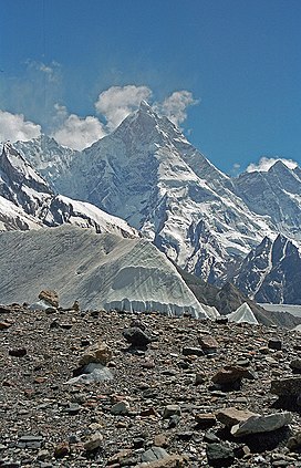
Baltoro Glacier, the Masherbrum Mountains contain some of the highest peaks in the world (highest 7,821 metres (25,659 ft)). They attract climbers from around the planet.
293:
The following is a table of the peaks in the
Masherbrum Mountains which are over 7,200 metres (23,620 ft) in elevation and have over 500 metres (1,640 ft) of
156:
710:
686:
75:
705:
119:
715:
679:
520:
460:
401:
342:
604:
68:
672:
609:
294:
656:
250:
203:
281:
266:
506:
447:
214:
699:
582:
236:
644:
375:
274:
270:
434:
329:
51:
535:
522:
475:
462:
416:
403:
357:
344:
90:
77:
553:
493:
388:
297:. (This is a common criterion for peaks of this stature to be independent.)
254:
246:
207:
140:
572:
Other notable peaks include the following ones in the Hushe Valley region:
652:
576:
193:
591:
32:
58:
265:
The
Masherbrum Mountains are located on the south side of the
299:
139:
Location of the
Masherbrum Mountains within the greater
660:
625:, Swiss Foundation for Alpine Research, Zurich, 1990.
213:
199:
189:
106:
67:
57:
47:
42:
21:
680:
8:
163:
126:
687:
673:
241:
24:
18:
269:. The southern side of the range, in the
257:region of Pakistan-administered Kashmir.
623:Orographical Sketch Map of the Karakoram
176:Masherbrum Mountains (Gilgit Baltistan)
7:
641:
639:
628:Andy Fanshawe and Stephen Venables,
711:Mountain ranges of Gilgit-Baltistan
240:
659:. You can help Knowledge (XXG) by
14:
706:Mountain ranges of the Karakoram
643:
162:
155:
125:
118:
31:
1:
632:, Hodder and Stoughton, 1995.
605:List of mountains in Pakistan
63:7,821 m (25,659 ft)
560:
557:
500:
497:
441:
438:
382:
379:
179:Show map of Gilgit Baltistan
549:
514:
511:
489:
454:
451:
430:
395:
392:
371:
336:
333:
280:While not as famous as the
732:
638:
610:List of highest mountains
273:basin, is drained by the
225:
111:
30:
716:Pakistan geography stubs
245:) are a subrange of the
655:location article is a
295:topographic prominence
249:mountains, located in
630:Himalaya Alpine-Style
536:35.41667°N 76.55083°E
476:35.63917°N 76.67333°E
417:35.61417°N 76.57917°E
358:35.64000°N 76.30583°E
146:Show map of Karakoram
91:35.64250°N 76.31083°E
233:Masherbrum Mountains
170:Masherbrum Mountains
133:Masherbrum Mountains
22:Masherbrum Mountains
532: /
472: /
413: /
354: /
324:Ascents (attempts)
87: /
541:35.41667; 76.55083
481:35.63917; 76.67333
422:35.61417; 76.57917
363:35.64000; 76.30583
96:35.64250; 76.31083
43:Highest point
668:
667:
565:
564:
229:
228:
723:
689:
682:
675:
647:
640:
547:
546:
544:
543:
542:
537:
533:
530:
529:
528:
525:
487:
486:
484:
483:
482:
477:
473:
470:
469:
468:
465:
428:
427:
425:
424:
423:
418:
414:
411:
410:
409:
406:
369:
368:
366:
365:
364:
359:
355:
352:
351:
350:
347:
318:Parent mountain
300:
251:Ghanche District
244:
243:
242:ما شربرم پہاڑیاں
217:
204:Ghanche District
180:
166:
165:
159:
147:
129:
128:
122:
102:
101:
99:
98:
97:
92:
88:
85:
84:
83:
80:
35:
26:
25:ما شربرم پہاڑیاں
19:
731:
730:
726:
725:
724:
722:
721:
720:
696:
695:
694:
693:
636:
618:
601:
588:Kapura, 6,544 m
570:
540:
538:
534:
531:
526:
523:
521:
519:
518:
480:
478:
474:
471:
466:
463:
461:
459:
458:
421:
419:
415:
412:
407:
404:
402:
400:
399:
362:
360:
356:
353:
348:
345:
343:
341:
340:
315:Prominence (m)
291:
282:Baltoro Muztagh
267:Baltoro Glacier
263:
215:
185:
184:
183:
182:
181:
178:
177:
174:
173:
172:
171:
167:
150:
149:
148:
145:
144:
137:
136:
135:
134:
130:
95:
93:
89:
86:
81:
78:
76:
74:
73:
38:
23:
17:
12:
11:
5:
729:
727:
719:
718:
713:
708:
698:
697:
692:
691:
684:
677:
669:
666:
665:
648:
634:
633:
626:
617:
614:
613:
612:
607:
600:
597:
596:
595:
589:
586:
580:
569:
566:
563:
562:
559:
556:
551:
548:
516:
513:
510:
507:Baltistan Peak
503:
502:
499:
496:
491:
488:
456:
453:
450:
448:Baltoro Kangri
444:
443:
440:
437:
432:
429:
397:
394:
391:
385:
384:
381:
378:
373:
370:
338:
335:
332:
326:
325:
322:
319:
316:
313:
310:
307:
304:
290:
289:Selected peaks
287:
262:
259:
227:
226:
223:
222:
219:
211:
210:
201:
197:
196:
191:
187:
186:
175:
169:
168:
161:
160:
154:
153:
152:
151:
138:
132:
131:
124:
123:
117:
116:
115:
114:
113:
112:
109:
108:
104:
103:
71:
65:
64:
61:
55:
54:
49:
45:
44:
40:
39:
36:
28:
27:
16:Mountain range
15:
13:
10:
9:
6:
4:
3:
2:
728:
717:
714:
712:
709:
707:
704:
703:
701:
690:
685:
683:
678:
676:
671:
670:
664:
662:
658:
654:
649:
646:
642:
637:
631:
627:
624:
620:
619:
615:
611:
608:
606:
603:
602:
598:
593:
590:
587:
584:
581:
578:
575:
574:
573:
567:
555:
552:
545:
517:
508:
505:
504:
495:
492:
485:
457:
449:
446:
445:
436:
433:
426:
398:
390:
387:
386:
377:
374:
367:
339:
331:
328:
327:
323:
321:First ascent
320:
317:
314:
311:
308:
305:
302:
301:
298:
296:
288:
286:
283:
278:
276:
272:
268:
260:
258:
256:
252:
248:
238:
234:
224:
220:
218:
212:
209:
205:
202:
198:
195:
192:
188:
158:
142:
121:
110:
105:
100:
72:
70:
66:
62:
60:
56:
53:
50:
46:
41:
34:
29:
20:
661:expanding it
650:
635:
629:
622:
621:Jerzy Wala,
571:
376:Gasherbrum I
312:Coordinates
309:Height (ft)
292:
279:
264:
232:
230:
216:Parent range
568:Other peaks
539: /
479: /
420: /
361: /
306:Height (m)
275:Hushe River
271:Indus River
94: /
69:Coordinates
700:Categories
527:76°33′03″E
524:35°25′00″N
467:76°40′24″E
464:35°38′21″N
435:Masherbrum
408:76°34′45″E
405:35°36′51″N
349:76°18′21″E
346:35°38′24″N
330:Masherbrum
82:76°18′39″E
79:35°38′33″N
52:Masherbrum
37:Masherbrum
594:, 6,447 m
585:, 6,934 m
579:, 7,041 m
554:Chogolisa
494:Chogolisa
389:Chogolisa
303:Mountain
261:Geography
255:Baltistan
247:Karakoram
221:Karakoram
208:Baltistan
141:Karakoram
107:Geography
59:Elevation
653:Pakistan
599:See also
577:Link Sar
194:Pakistan
616:Sources
592:Drifika
515:23,891
455:23,990
396:25,148
337:25,659
253:in the
190:Country
561:1 (3)
550:1,962
512:7,282
501:1 (0)
490:1,040
452:7,312
442:4 (2)
431:1,624
393:7,665
383:4 (9)
372:2,457
334:7,821
200:Region
143:region
651:This
558:1970
509:(K6)
498:1976
439:1975
380:1960
657:stub
237:Urdu
231:The
48:Peak
702::
583:K7
277:.
239::
206:,
688:e
681:t
674:v
663:.
235:(
Text is available under the Creative Commons Attribution-ShareAlike License. Additional terms may apply.