20:
67:. The river then continues to its mouth at Greenwich Cove, on the north side of Potowomut Peninsula. Dark Entry Brook is the Maskerchugg River's only named tributary, though it has many unnamed streams that also feed it. There are four dams along the river's length.
741:
780:
613:
760:
450:
672:
445:
59:
near the intersection of
Cowesett Road and Paddock Drive. From there, the river flows east along Cowesett Road, then turns southeast and flows past
19:
785:
770:
734:
186:
775:
727:
608:
535:
525:
199:
144:
765:
540:
195:
131:
505:
60:
455:
301:
64:
530:
485:
415:
266:
75:
Below is a list of all crossings over the
Maskerchugg River. The list starts at the headwaters and goes downstream.
435:
311:
291:
654:
545:
376:
405:
94:
276:
247:
179:
555:
56:
357:
343:
157:
639:
207:
116:
24:
470:
238:
224:
216:
172:
711:
515:
510:
465:
410:
391:
352:
334:
281:
164:
644:
480:
430:
425:
381:
367:
296:
286:
252:
589:
574:
565:
495:
460:
271:
158:
Governor's Task Force on Dam Safety and
Maintenance – Final Report, January 2001
754:
618:
579:
520:
490:
440:
261:
40:
623:
599:
584:
500:
475:
320:
110:
44:
550:
420:
400:
687:
674:
36:
18:
168:
715:
710:
This article related to a river in Rhode Island is a
632:
598:
564:
390:
366:
342:
333:
310:
246:
237:
215:
206:
47:. It flows approximately 4 miles (6.4 km).
735:
180:
8:
742:
728:
339:
243:
212:
187:
173:
165:
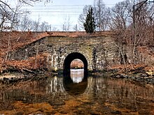
27:over the Maskerchugg River near its mouth
55:The river rises from an unnamed pond in
150:
781:Northeastern United States river stubs
7:
707:
705:
16:River in Rhode Island, United States
761:Rivers of Kent County, Rhode Island
714:. You can help Knowledge (XXG) by
446:Flat River (South Branch Pawtuxet)
14:
145:United States Geological Survey
132:List of rivers in Rhode Island
1:
82:Cowesett Road (two crossings)
786:Rhode Island geography stubs
771:East Greenwich, Rhode Island
23:An arch bridge carrying the
531:South Branch Pawtuxet River
486:North Branch Pawtuxet River
802:
704:
688:41.681861°N 71.482000°W
248:Little Narragansett Bay
776:Rivers of Rhode Island
196:Rivers of Rhode Island
28:
766:Warwick, Rhode Island
693:41.681861; -71.482000
556:Woonasquatucket River
22:
358:Pettaquamscutt River
344:Pettaquamscutt River
684: /
640:Annaquatucket River
208:Block Island Sound
117:Northeast Corridor
29:
25:Northeast Corridor
723:
722:
667:
666:
663:
662:
650:Maskerchugg River
471:Moswansicut River
329:
328:
277:Flat River (Wood)
239:Long Island Sound
233:
232:
225:Saugatucket River
217:Point Judith Pond
93:Division Street (
33:Maskerchugg River
793:
744:
737:
730:
706:
699:
698:
696:
695:
694:
689:
685:
682:
681:
680:
677:
609:Barrington River
536:Stillwater River
516:Providence River
511:Ponaganset River
466:Moshassuck River
411:Blackstone River
392:Providence River
353:Mattatuxet River
340:
335:Narragansett Bay
282:Green Fall River
244:
213:
189:
182:
175:
166:
160:
155:
801:
800:
796:
795:
794:
792:
791:
790:
751:
750:
749:
748:
702:
692:
690:
686:
683:
678:
675:
673:
671:
670:
668:
659:
645:Kickemuit River
628:
594:
560:
526:Sevenmile River
481:Nooseneck River
431:Chockalog River
426:Chepachet River
386:
382:Potowomut River
368:Potowomut River
362:
325:
306:
297:Usquepaug River
287:Pawcatuck River
253:Pawcatuck River
250:
229:
202:
200:drainage system
193:
163:
156:
152:
140:
128:
90:East Greenwich
73:
53:
17:
12:
11:
5:
799:
797:
789:
788:
783:
778:
773:
768:
763:
753:
752:
747:
746:
739:
732:
724:
721:
720:
665:
664:
661:
660:
658:
657:
652:
647:
642:
636:
634:
630:
629:
627:
626:
621:
616:
611:
605:
603:
596:
595:
593:
592:
590:Sakonnet River
587:
582:
577:
575:Maidford River
571:
569:
566:Sakonnet River
562:
561:
559:
558:
553:
548:
543:
541:Ten Mile River
538:
533:
528:
523:
518:
513:
508:
506:Pocasset River
503:
498:
496:Pawtuxet River
493:
488:
483:
478:
473:
468:
463:
461:Mishnock River
458:
453:
448:
443:
438:
433:
428:
423:
418:
413:
408:
403:
397:
395:
388:
387:
385:
384:
379:
373:
371:
364:
363:
361:
360:
355:
349:
347:
337:
331:
330:
327:
326:
324:
323:
317:
315:
308:
307:
305:
304:
299:
294:
289:
284:
279:
274:
272:Chipuxet River
269:
264:
258:
256:
241:
235:
234:
231:
230:
228:
227:
221:
219:
210:
204:
203:
194:
192:
191:
184:
177:
169:
162:
161:
149:
148:
147:
143:Maps from the
139:
136:
135:
134:
127:
124:
123:
122:
121:
120:
114:
107:
104:
103:Green Hill Way
101:
98:
88:
87:
86:
83:
72:
69:
65:East Greenwich
52:
49:
15:
13:
10:
9:
6:
4:
3:
2:
798:
787:
784:
782:
779:
777:
774:
772:
769:
767:
764:
762:
759:
758:
756:
745:
740:
738:
733:
731:
726:
725:
719:
717:
713:
708:
703:
700:
697:
656:
653:
651:
648:
646:
643:
641:
638:
637:
635:
631:
625:
622:
620:
619:Runnins River
617:
615:
612:
610:
607:
606:
604:
601:
597:
591:
588:
586:
583:
581:
580:Maiford River
578:
576:
573:
572:
570:
567:
563:
557:
554:
552:
549:
547:
544:
542:
539:
537:
534:
532:
529:
527:
524:
522:
521:Seekonk River
519:
517:
514:
512:
509:
507:
504:
502:
499:
497:
494:
492:
491:Pascoag River
489:
487:
484:
482:
479:
477:
474:
472:
469:
467:
464:
462:
459:
457:
456:Millers River
454:
452:
449:
447:
444:
442:
441:Congdon River
439:
437:
434:
432:
429:
427:
424:
422:
419:
417:
414:
412:
409:
407:
404:
402:
399:
398:
396:
393:
389:
383:
380:
378:
375:
374:
372:
369:
365:
359:
356:
354:
351:
350:
348:
345:
341:
338:
336:
332:
322:
319:
318:
316:
313:
309:
303:
300:
298:
295:
293:
290:
288:
285:
283:
280:
278:
275:
273:
270:
268:
265:
263:
262:Ashaway River
260:
259:
257:
254:
249:
245:
242:
240:
236:
226:
223:
222:
220:
218:
214:
211:
209:
205:
201:
197:
190:
185:
183:
178:
176:
171:
170:
167:
159:
154:
151:
146:
142:
141:
137:
133:
130:
129:
125:
118:
115:
112:
109:Main Street (
108:
106:Kenyon Avenue
105:
102:
99:
96:
92:
91:
89:
85:Interstate 95
84:
81:
80:
78:
77:
76:
70:
68:
66:
62:
61:Interstate 95
58:
50:
48:
46:
42:
38:
34:
26:
21:
716:expanding it
709:
701:
679:71°28′55.2″W
676:41°40′54.7″N
669:
649:
624:Warren River
614:Palmer River
600:Warren River
585:Quaket River
501:Peters River
476:Nipmuc River
416:Branch River
321:Moosup River
312:Thames River
267:Beaver River
153:
111:U.S. Route 1
100:Sylvan Drive
74:
54:
45:Rhode Island
32:
30:
691: /
551:Wilde River
436:Clear River
292:Queen River
755:Categories
655:Pine River
546:West River
451:Mill River
421:Carr River
401:Abbott Run
377:Hunt River
302:Wood River
255:Watershed)
138:References
602:Watershed
568:Watershed
406:Big River
394:Watershed
370:Watershed
346:Watershed
314:Watershed
119:rail line
95:Route 401
71:Crossings
43:state of
126:See also
79:Warwick
57:Warwick
39:in the
633:Others
51:Course
37:river
35:is a
712:stub
41:U.S.
31:The
198:by
63:to
757::
743:e
736:t
729:v
718:.
251:(
188:e
181:t
174:v
113:)
97:)
Text is available under the Creative Commons Attribution-ShareAlike License. Additional terms may apply.