185:
25:
192:
99:
300:
and is considerably better known than
Ishpatina Ridge. It ranks thirteenth, but when ranked by vertical rise it is the highest of the top 25 peaks in Ontario. The 30 m (100 ft) fire tower is also still intact and attracts many hikers. A 3.2-kilometre-long
406:
354:
316:, the mountain is not very accessible; roads and trails in the remote area are difficult to travel in poor weather. The most popular approach routes to Maple Mountain are by
416:
141:
54:
411:
184:
277:
331:, meaning "the place where the spirits go" and consider it a sacred site. The English name of the mountain was given by Dr. Robert Bell of the
76:
239:
401:
396:
134:
332:
236:
349:
37:
47:
41:
33:
297:
124:
58:
324:
288:. It has a higher vertical rise over the surrounding landscape, 37 m (121 ft) higher than the
313:
309:
285:
281:
293:
242:
344:
289:
231:
223:
366:
216:
390:
302:
254:
156:
143:
98:
376:
273:
335:
in 1888. Bell was the first known non-aboriginal to scale the mountain.
204:
261:
114:
381:
371:
317:
18:
355:
List of highest points of
Canadian provinces and territories
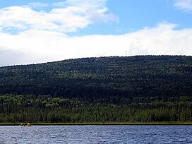
292:, which is the highest point of land in Ontario rising over
407:
Religious places of the
Indigenous peoples of North America
253:
248:
230:
215:
172:
133:
123:
113:
108:
91:
367:Maple Mountain Myth - The highest point in Ontario
46:but its sources remain unclear because it lacks
284:, Canada, estimated 642 m (2,106 ft)
8:
88:
77:Learn how and when to remove this message
278:Lady Evelyn-Smoothwater Provincial Park
191:
103:Maple Mountain rising over Tupper Lake
417:Mountains of Canada under 1000 metres
7:
305:leads to the abandoned fire tower.
14:
412:Sacred mountains of the Americas
190:
183:
97:
23:
1:
377:Ontario's Highest Elevations
296:. Maple Mountain rises over
333:Geological Survey of Canada
16:Mountain in Ontario, Canada
433:
129:351 m (1,152 ft)
119:642 m (2,106 ft)
350:Temagami Magnetic Anomaly
177:
96:
372:Maple Mountain firetower
32:This article includes a
61:more precise citations.
325:Temagami First Nation
402:Mountains of Ontario
320:and/or float plane.
314:Northeastern Ontario
310:Timiskaming District
286:above mean sea level
282:Northeastern Ontario
397:Anishinaabe culture
382:Friends of Temagami
153: /
327:call the mountain
109:Highest point
34:list of references
276:, located within
267:
266:
157:47.383°N 80.333°W
87:
86:
79:
424:
257:
243:Lady Evelyn Lake
219:
194:
193:
187:
168:
167:
165:
164:
163:
158:
154:
151:
150:
149:
146:
101:
89:
82:
75:
71:
68:
62:
57:this article by
48:inline citations
27:
26:
19:
432:
431:
427:
426:
425:
423:
422:
421:
387:
386:
363:
345:Ishpatina Ridge
341:
323:The indigenous
290:Ishpatina Ridge
255:
226:, unnamed range
224:Canadian Shield
217:
211:
210:
209:
208:
207:
202:
201:
200:
199:
195:
162:47.383; -80.333
161:
159:
155:
152:
147:
144:
142:
140:
139:
104:
83:
72:
66:
63:
52:
38:related reading
28:
24:
17:
12:
11:
5:
430:
428:
420:
419:
414:
409:
404:
399:
389:
388:
385:
384:
379:
374:
369:
362:
361:External links
359:
358:
357:
352:
347:
340:
337:
294:Scarecrow Lake
270:Maple Mountain
265:
264:
259:
251:
250:
246:
245:
234:
228:
227:
221:
213:
212:
203:
198:Maple Mountain
197:
196:
189:
188:
182:
181:
180:
179:
178:
175:
174:
170:
169:
137:
131:
130:
127:
121:
120:
117:
111:
110:
106:
105:
102:
94:
93:
92:Maple Mountain
85:
84:
42:external links
31:
29:
22:
15:
13:
10:
9:
6:
4:
3:
2:
429:
418:
415:
413:
410:
408:
405:
403:
400:
398:
395:
394:
392:
383:
380:
378:
375:
373:
370:
368:
365:
364:
360:
356:
353:
351:
348:
346:
343:
342:
338:
336:
334:
330:
329:Chee-bay-jing
326:
321:
319:
315:
311:
306:
304:
299:
295:
291:
287:
283:
279:
275:
271:
263:
260:
258:
256:Easiest route
252:
247:
244:
241:
238:
235:
233:
229:
225:
222:
220:
214:
206:
186:
176:
171:
166:
138:
136:
132:
128:
126:
122:
118:
116:
112:
107:
100:
95:
90:
81:
78:
70:
60:
56:
50:
49:
43:
39:
35:
30:
21:
20:
328:
322:
307:
303:hiking trail
269:
268:
218:Parent range
73:
64:
53:Please help
45:
308:Located in
298:Tupper Lake
160: /
135:Coordinates
59:introducing
391:Categories
125:Prominence
173:Geography
115:Elevation
67:July 2024
339:See also
274:mountain
249:Climbing
232:Topo map
205:Ontario
148:80°20′W
145:47°23′N
55:improve
318:canoe
272:is a
40:, or
262:Hike
240:41P8
312:of
237:NTS
393::
280:,
44:,
36:,
80:)
74:(
69:)
65:(
51:.
Text is available under the Creative Commons Attribution-ShareAlike License. Additional terms may apply.