74:
99:
57:
944:
248:
955:
106:
81:
456:
259:
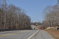
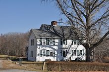
bordered on both sides by stone walls about 50 feet apart for most of the way. As of 2002, the walls were clearly visible at some times of the year, although overgrown in places, but difficult to see in the summer. The only concentration of houses as of 2002 was of 18th- and 19th-century houses in the
289:
The area listed is the roadway owned by the
Connecticut State Department of Transportation, and not the adjacent properties. In 1781, the roadway was poor, at least to the east of the hamlet of Plainfield just east of the listed district, and it caused difficulty for the artillery and baggage trains
271:
at the time), which was mentioned in multiple French accounts of the marches and which is also NRHP-listed. The segment includes views of farm fields and other countryside suggestive of how the land would have appeared in 1781 and 1782 for the troops marching through, including views west to ridges
280:
Although it is now a paved state highway, the road retains its narrow, hilly, winding character, and for most of its length, the characteristic borders of stone walls remain in place. This is the longest continuous portion of the route to survive with these physical attributes intact. This is also
258:
It is a linear historic district consisting of a portion of
Connecticut Route 14A, locally known as Plainfield Pike, which is level in the eastern part but generally hilly with curves. Along the route is open land of pasture and cornfields, wooded areas, and streams, including Ekonk Brook. It is
294:
in Rhode Island. Frenchman
Clermont-Crevecoeur's journal recorded: "very bad roads. The artillery and the supply wagons arrived very late" at the Plainfield camp. Von Closen agreed, "The roads were still very bad", as did du Bourg: "The roads still quite bad, many stragglers".
833:
928:
864:
848:
1004:
838:
1014:
979:
1009:
260:
923:
869:
510:
890:
792:
984:
823:
757:
722:
797:
702:
662:
487:
762:
752:
747:
727:
843:
677:
592:
312:
712:
707:
582:
802:
767:
672:
647:
787:
737:
717:
692:
682:
667:
657:
642:
622:
597:
587:
577:
807:
782:
687:
627:
607:
602:
572:
562:
742:
697:
637:
612:
567:
73:
138:
874:
772:
652:
617:
98:
828:
777:
732:
632:
540:
525:
480:
556:
989:
307:
958:
473:
948:
298:
There are multiple other properties associated with
Rochambeau's route that were also considered for listing on the National Register in a 2001 study.
460:
520:
43:
496:
340:
241:
34:
911:
999:
240:'s army in June 1781 on its way to Yorktown, Virginia, and again of the returning army in November 1782. It was listed on the
994:
178:
442:"National Register of Historic Places Multiple Property Documentation: Rochambeau's Army in Connecticut, 1780-1782 MPS"
916:
895:
229:
126:
56:
530:
268:
535:
515:
345:
233:
370:"National Register of Historic Places Registration: March Route of Rochambeau's Army: Plainfield Pike"
291:
237:
399:
393:
378:
282:
465:
441:
369:
183:
401:
Accompanying three photos, exterior, from 2001 (see map captions page 12 of text document)
273:
247:
196:
973:
285:). Elsewhere, the route has been too affected by re-forestation to allow such views.
929:
University and college buildings listed on the
National Register of Historic Places
281:
the only portion of the route that still offers repeated vistas of distant ridges (
264:
251:
153:
140:
105:
80:
455:
924:
List of jails and prisons on the
National Register of Historic Places
1015:
National
Register of Historic Places in Windham County, Connecticut
454:
246:
394:"National Register of Historic Places Registration: Dorrance Inn"
335:
1005:
Historic places on the
Washington–Rochambeau Revolutionary Route
980:
Roads on the
National Register of Historic Places in Connecticut
1010:
American
Revolution on the National Register of Historic Places
469:
276:
valley. According to the NRHP nomination for the district:
290:
making their way to Plainfield from their second camp near
363:
361:
359:
357:
355:
313:
List of historic sites preserved along Rochambeau's route
985:
Buildings and structures in Windham County, Connecticut
236:
which forms a portion of the historic march route of
904:
883:
857:
816:
549:
526:
History of the National Register of Historic Places
503:
440:Bruce Clouette and Mary Harper (October 22, 2001).
215:
207:
202:
189:
177:
169:
132:
122:
557:List of U.S. National Historic Landmarks by state
226:March Route of Rochambeau's Army: Plainfield Pike
27:March Route of Rochambeau's Army: Plainfield Pike
368:Mary Harper and Bruce Clouette (December 2002).
949:National Register of Historic Places portal
184:Rochambeau's Army in Connecticut, 1780-1782 MPS
481:
61:the march route along Plainfield Pike in 2016
8:
488:
474:
466:
55:
497:U.S. National Register of Historic Places
308:Washington–Rochambeau Revolutionary Route
35:U.S. National Register of Historic Places
324:
990:Connecticut in the American Revolution
336:"National Register Information System"
330:
328:
18:
7:
341:National Register of Historic Places
242:National Register of Historic Places
392:Bruce Clouette (February 1, 2001).
228:is a 3.6 mile-long road segment in
912:National Historic Preservation Act
430:du Bourg, Vol. 4 (April 1880): 293
14:
380:Accompanying 14 photos, from 2001
954:
953:
942:
104:
97:
79:
72:
267:in Sterling (which was part of
261:Sterling Hill Historic District
865:Federated States of Micronesia
511:Architectural style categories
191:
1:
263:section. Among these is the
113:Show map of the United States
16:United States historic place
412:Rice and Brown 1972 (I): 28
1031:
917:Historic Preservation Fund
896:American Legation, Morocco
937:
858:Lists by associated state
190:NRHP reference
66:
54:
50:
41:
32:
25:
21:
839:Northern Mariana Islands
447:. National Park Service.
396:. National Park Service.
375:. National Park Service.
272:on the west side of the
1000:Plainfield, Connecticut
127:Plainfield, Connecticut
88:Show map of Connecticut
834:Minor Outlying Islands
817:Lists by insular areas
531:Keeper of the Register
463:
287:
255:
173:22 acres (8.9 ha)
44:U.S. Historic district
995:Sterling, Connecticut
536:National Park Service
516:Contributing property
458:
346:National Park Service
278:
250:
234:Sterling, Connecticut
208:Dates of significance
154:41.68167°N 71.86389°W
891:District of Columbia
421:von Closen 1958: 85
283:Photographs 3 and 4
238:Comte de Rochambeau
159:41.68167; -71.86389
150: /
464:
256:
967:
966:
521:Historic district
348:. March 13, 2009.
292:Waterman's Tavern
223:
222:
203:Significant dates
1022:
957:
956:
947:
946:
945:
870:Marshall Islands
490:
483:
476:
467:
449:
448:
446:
437:
431:
428:
422:
419:
413:
410:
404:
397:
389:
383:
376:
374:
365:
350:
349:
332:
244:(NRHP) in 2003.
193:
165:
164:
162:
161:
160:
155:
151:
148:
147:
146:
143:
114:
108:
107:
101:
89:
83:
82:
76:
59:
19:
1030:
1029:
1025:
1024:
1023:
1021:
1020:
1019:
970:
969:
968:
963:
943:
941:
933:
900:
879:
853:
812:
545:
499:
494:
459:NPS map of the
453:
452:
444:
439:
438:
434:
429:
425:
420:
416:
411:
407:
391:
390:
386:
372:
367:
366:
353:
334:
333:
326:
321:
304:
274:Quinebaug River
158:
156:
152:
149:
144:
141:
139:
137:
136:
118:
117:
116:
115:
112:
111:
110:
109:
92:
91:
90:
87:
86:
85:
84:
62:
46:
37:
28:
17:
12:
11:
5:
1028:
1026:
1018:
1017:
1012:
1007:
1002:
997:
992:
987:
982:
972:
971:
965:
964:
962:
961:
951:
938:
935:
934:
932:
931:
926:
921:
920:
919:
908:
906:
902:
901:
899:
898:
893:
887:
885:
881:
880:
878:
877:
872:
867:
861:
859:
855:
854:
852:
851:
849:Virgin Islands
846:
841:
836:
831:
826:
824:American Samoa
820:
818:
814:
813:
811:
810:
805:
800:
795:
790:
785:
780:
775:
770:
765:
760:
758:South Carolina
755:
750:
745:
740:
735:
730:
725:
723:North Carolina
720:
715:
710:
705:
700:
695:
690:
685:
680:
675:
670:
665:
660:
655:
650:
645:
640:
635:
630:
625:
620:
615:
610:
605:
600:
595:
590:
585:
580:
575:
570:
565:
560:
553:
551:
550:Lists by state
547:
546:
544:
543:
541:Property types
538:
533:
528:
523:
518:
513:
507:
505:
501:
500:
495:
493:
492:
485:
478:
470:
451:
450:
432:
423:
414:
405:
384:
351:
323:
322:
320:
317:
316:
315:
310:
303:
300:
221:
220:
217:
213:
212:
209:
205:
204:
200:
199:
194:
187:
186:
181:
175:
174:
171:
167:
166:
134:
130:
129:
124:
120:
119:
103:
102:
96:
95:
94:
93:
78:
77:
71:
70:
69:
68:
67:
64:
63:
60:
52:
51:
48:
47:
42:
39:
38:
33:
30:
29:
26:
23:
22:
15:
13:
10:
9:
6:
4:
3:
2:
1027:
1016:
1013:
1011:
1008:
1006:
1003:
1001:
998:
996:
993:
991:
988:
986:
983:
981:
978:
977:
975:
960:
952:
950:
940:
939:
936:
930:
927:
925:
922:
918:
915:
914:
913:
910:
909:
907:
903:
897:
894:
892:
889:
888:
886:
882:
876:
873:
871:
868:
866:
863:
862:
860:
856:
850:
847:
845:
842:
840:
837:
835:
832:
830:
827:
825:
822:
821:
819:
815:
809:
806:
804:
801:
799:
798:West Virginia
796:
794:
791:
789:
786:
784:
781:
779:
776:
774:
771:
769:
766:
764:
761:
759:
756:
754:
751:
749:
746:
744:
741:
739:
736:
734:
731:
729:
726:
724:
721:
719:
716:
714:
711:
709:
706:
704:
703:New Hampshire
701:
699:
696:
694:
691:
689:
686:
684:
681:
679:
676:
674:
671:
669:
666:
664:
663:Massachusetts
661:
659:
656:
654:
651:
649:
646:
644:
641:
639:
636:
634:
631:
629:
626:
624:
621:
619:
616:
614:
611:
609:
606:
604:
601:
599:
596:
594:
591:
589:
586:
584:
581:
579:
576:
574:
571:
569:
566:
564:
561:
558:
555:
554:
552:
548:
542:
539:
537:
534:
532:
529:
527:
524:
522:
519:
517:
514:
512:
509:
508:
506:
502:
498:
491:
486:
484:
479:
477:
472:
471:
468:
462:
457:
443:
436:
433:
427:
424:
418:
415:
409:
406:
403:
402:
395:
388:
385:
382:
381:
371:
364:
362:
360:
358:
356:
352:
347:
343:
342:
337:
331:
329:
325:
318:
314:
311:
309:
306:
305:
301:
299:
296:
293:
286:
284:
277:
275:
270:
266:
262:
253:
249:
245:
243:
239:
235:
231:
227:
218:
216:Added to NRHP
214:
210:
206:
201:
198:
195:
188:
185:
182:
180:
176:
172:
168:
163:
135:
131:
128:
125:
121:
100:
75:
65:
58:
53:
49:
45:
40:
36:
31:
24:
20:
763:South Dakota
753:Rhode Island
748:Pennsylvania
728:North Dakota
435:
426:
417:
408:
400:
387:
379:
339:
297:
288:
279:
265:Dorrance Inn
257:
252:Dorrance Inn
225:
224:
219:June 6, 2003
123:Nearest city
884:Other areas
844:Puerto Rico
678:Mississippi
593:Connecticut
157: /
133:Coordinates
974:Categories
793:Washington
713:New Mexico
708:New Jersey
583:California
319:References
230:Plainfield
211:1781, 1782
145:71°51′50″W
142:41°40′54″N
803:Wisconsin
768:Tennessee
673:Minnesota
648:Louisiana
461:W3R Route
269:Voluntown
959:Category
788:Virginia
738:Oklahoma
718:New York
693:Nebraska
683:Missouri
668:Michigan
658:Maryland
643:Kentucky
623:Illinois
598:Delaware
588:Colorado
578:Arkansas
302:See also
197:03000312
905:Related
808:Wyoming
783:Vermont
688:Montana
628:Indiana
608:Georgia
603:Florida
573:Arizona
563:Alabama
254:in 2016
743:Oregon
698:Nevada
638:Kansas
613:Hawaii
568:Alaska
504:Topics
875:Palau
773:Texas
653:Maine
618:Idaho
445:(PDF)
373:(PDF)
829:Guam
778:Utah
733:Ohio
633:Iowa
398:and
377:and
232:and
170:Area
192:No.
179:MPS
976::
354:^
344:.
338:.
327:^
559::
489:e
482:t
475:v
Text is available under the Creative Commons Attribution-ShareAlike License. Additional terms may apply.