369:
236:
1056:
24:
1139:. At 3:16 p.m. the tornado either formed a new funnel or changed course as it tracked into the west side of Marion along Illinois Route 13, causing extensive damage throughout the city. During this time the tornado was observed have a
319:
was draped over
Central Illinois and Missouri from overnight convection that was decaying as it tracked east across the two states. This outflow boundary provided the potential for storms to redevelop. By mid-afternoon, temperatures at
1155:
and
Illinois Route 13 interchange including the Marion Ford dealership, and also damaged two schools, 648 homes, and 52 businesses. It caused 10 deaths and 181 injuries, and left over 1,000 people homeless.
573:
1165:
1866:
1651:
885:
703:
A house and a power station were damaged near Percy. Four homes were destroyed and five were damaged in Conant. Seven people were injured. Damage was estimated at $ 300,000.
958:
811:
500:
1744:
733:
655:
1795:
1363:
1856:
1151:. The tornado had destroyed the Shawnee Village Apartment Complex and severely damaged three shopping centers. It heavily damaged the area surrounding the
556:
1820:
1681:
1184:
1881:
1136:
1659:
1851:
1825:
1523:
1188:
782:
1296:
1781:
1871:
1846:
1788:
1685:
1628:
1600:
1572:
1544:
1488:
1460:
1432:
1404:
1322:
1270:
1374:
1714:
1221:
721:
345:
341:
1876:
1025:
1861:
639:
1722:
349:
333:
308:
244:
194:
1252:
1140:
873:
868:
799:
312:
1718:
1247:
946:
643:
488:
1128:
1124:
712:
353:
337:
304:
288:
1689:
1623:
1595:
1567:
1539:
1483:
1455:
1427:
1399:
1192:
1132:
794:
321:
300:
292:
561:
1148:
941:
483:
296:
219:, being the hardest hit. Ten fatalities occurred there after the town took a direct hit from an
1147:, causing it to explode. By 3:30 p.m. the tornado had exited the city and dissipated near
1815:
1804:
1519:
1143:
with up to three subvortices swirling around the main tornado. The tornado struck a car along
462:
164:
33:
716:
634:
316:
276:
224:
216:
190:
630:
357:
1300:
272:
1840:
1152:
1144:
329:
29:
1114:
1084:
1046:
444:
378:
220:
172:
97:
1326:
1274:
473:
368:
325:
280:
248:
235:
1759:
1746:
974:
960:
901:
887:
827:
813:
749:
735:
671:
657:
589:
575:
516:
502:
451:
448:
1773:
1726:
1225:
1021:
621:
A small, brief tornado heavily damaged or destroyed several farm buildings.
284:
252:
1055:
878:
804:
726:
648:
493:
264:
208:
204:
154:
146:
1131:. It then tracked into downtown Carterville then tracked southeast into
1655:
951:
212:
200:
150:
23:
1516:
Significant tornadoes, 1680-1991: A Chronology and
Analysis of Events
260:
239:
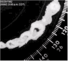
Radar loop of the storm that produced the Marion, Illinois, tornado.
1518:. St. Johnsbury, Vermont: Environmental Films. pp. 1241–1242.
328:
with dew points near 70 °F (21 °C). At 1:03 p.m., a
1715:"NOAA/NWS 1982 Williamson County / Marion, IL F4 Tornado Web Site"
367:
268:
234:
1725:
Paducah, KY Weather
Forecast Office. May 27, 2012. Archived from
1373:. National Oceanic and Atmospheric Administration. Archived from
1135:, after which it caused moderate damage to the area surrounding
566:
352:
and
Williamson County. At 3:00 p.m, a tornado was observed near
256:
223:
tornado. The outbreak also produced an F3 tornado affecting the
1777:
299:. 70 or 71 °F (21 or 22 °C) dew points were found in
1127:, at 3:00 p.m. resulting in damage to a subdivision near
283:
positioned east across northern
Illinois and Indiana. Morning
227:, area and several weaker tornadoes in the surrounding area.
1248:"Timeline on tornado that devastated Marion on May 29, 1982"
1024:
where the tornado touched down; however, all times are in
1632:(Report). National Oceanic and Atmospheric Administration
1604:(Report). National Oceanic and Atmospheric Administration
1576:(Report). National Oceanic and Atmospheric Administration
1548:(Report). National Oceanic and Atmospheric Administration
1492:(Report). National Oceanic and Atmospheric Administration
1464:(Report). National Oceanic and Atmospheric Administration
1436:(Report). National Oceanic and Atmospheric Administration
1408:(Report). National Oceanic and Atmospheric Administration
1166:
List of North
American tornadoes and tornado outbreaks
372:
Satellite photo of the clouds that produced the storm.
332:
was issued for the region. Later in the afternoon the
859:
A "spot touchdown" damaged a barn and several trees.
439:
List of confirmed tornadoes – Saturday, May 29, 1982
1103:
1077:
1045:
470:
467:
460:
457:
454:
443:
324:, and Marion had risen to the middle and upper 80s°
142:
134:
126:
104:
90:
80:
60:
52:
1185:"The thirty most damaging tornadoes since 1890"
933:Power lines were downed. No path was observed.
1371:National Centers for Environmental Information
344:and surrounding counties. At 2:58 p.m. a
1789:
1216:
1214:
1212:
1210:
340:, issued several severe weather warnings for
8:
1265:
1263:
1040:
16:
1867:1982 natural disasters in the United States
1509:
1507:
1796:
1782:
1774:
1358:
1356:
1354:
1352:
1350:
1348:
1346:
1344:
1323:"1982 Marion, Illinois Tornado Then / Now"
1299:. NOAA/NWS. March 28, 2006. Archived from
1222:"1982 Marion, Illinois Tornado Storm Path"
1054:
1039:
437:
22:
15:
1325:. NOAA/NWS. June 27, 2007. Archived from
1273:. NOAA/NWS. June 27, 2007. Archived from
1224:. NOAA/NWS. June 27, 2007. Archived from
375:
1271:"1982 Marion, Illinois Tornado Weather"
1176:
1013:
287:ranged from 65 °F (18 °C) at
193:that affected southern portions of the
178:Time from first tornado to last tornado
1364:"Storm Data: May 1982 Volume 24 No. 5"
1297:"Weather Gloassary for Storm Spotters"
1123:The Marion tornado touched down near
7:
1857:May 1982 events in the United States
1137:Williamson County Regional Airport
601:Caesarscreek Township (May 29, F1)
548:A brief tornado destroyed a shed.
14:
1596:Illinois Event Report: F0 Tornado
1568:Illinois Event Report: F0 Tornado
1540:Illinois Event Report: F4 Tornado
1484:Illinois Event Report: F3 Tornado
1456:Illinois Event Report: F3 Tornado
1400:Missouri Event Report: F1 Tornado
1189:National Severe Storms Laboratory
1020:All dates are based on the local
1006:A service station was destroyed.
187:Marion, Illinois tornado outbreak
17:Marion, Illinois tornado outbreak
1658:. March 11, 2007. Archived from
1624:Indiana Event Report: F1 Tornado
1113:Most severe tornado damage; see
295:, to 72 °F (22 °C) at
171:Most severe tornado damage; see
1078:
937:
863:
789:
707:
625:
552:
478:
91:
28:The F4 Marion tornado crossing
203:touched down in the states of
1:
1686:National Climatic Data Center
1652:"Top 5 Most Severe Tornadoes"
1629:National Climatic Data Center
1601:National Climatic Data Center
1573:National Climatic Data Center
1545:National Climatic Data Center
1489:National Climatic Data Center
1461:National Climatic Data Center
1433:National Climatic Data Center
1428:Ohio Event Report: F1 Tornado
1405:National Climatic Data Center
1514:Grazulis, Thomas P. (1993).
1882:Williamson County, Illinois
1107:10 fatalities, 181 injuries
785:– 181 people were injured.
783:See section on this tornado
542:0.06 miles (0.097 km)
346:severe thunderstorm warning
1898:
1060:Damage to the Marion area.
1026:Coordinated Universal Time
913:Carrier Mills (May 29, F0)
615:0.25 miles (0.40 km)
138:>$ 166 million 1997 USD
1811:
1805:Tornado outbreaks of 1982
1141:multiple-vortex structure
1111:
1099:
1095:
1091:
1073:
1069:
1065:
1053:
405:
402:
399:
396:
393:
390:
387:
384:
165:tornado outbreaks of 1982
160:
122:
118:
114:
76:
72:
68:
48:
44:
40:
21:
1852:F4 tornadoes by location
1723:National Weather Service
1041:Marion, Illinois tornado
377:Confirmed tornadoes by
334:National Weather Service
309:Cape Girardeau, Missouri
275:was found just south of
195:Midwestern United States
839:Harrisburg (May 29, F0)
778:400 yards (370 m)
700:200 yards (180 m)
313:Fort Campbell, Kentucky
231:Meteorological synopsis
130:10 deaths, 188 injuries
1719:West Paducah, Kentucky
1682:"Event Record Details"
986:Princeton (May 29, F1)
775:17 miles (27 km)
697:10 miles (16 km)
373:
240:
1872:Tornadoes in Illinois
1129:John A. Logan College
618:50 yards (46 m)
557:Caesarscreek Township
545:20 yards (18 m)
528:Columbia (May 29, F1)
371:
354:Carterville, Illinois
338:Saint Louis, Missouri
289:Saint Louis, Missouri
238:
1847:F4 tornadoes by date
1133:Crainville, Illinois
322:Carbondale, Illinois
301:Fort Smith, Arkansas
293:Louisville, Kentucky
189:was a small, severe
110:13 hours, 10 minutes
1756: /
1729:on October 16, 2012
1329:on October 25, 2012
1277:on October 25, 2012
1228:on October 15, 2012
1195:on February 7, 2012
1042:
970: /
897: /
823: /
761:Marion (May 29, F4)
745: /
683:Conant (May 29, F3)
667: /
585: /
512: /
440:
381:
364:Confirmed tornadoes
18:
1149:Illinois Route 166
438:
376:
374:
360:at 3:19 p.m.
297:Memphis, Tennessee
241:
1877:Tornadoes of 1982
1834:
1833:
1760:37.733°N 88.933°W
1121:
1120:
1010:
1009:
436:
435:
342:Williamson County
255:southwest across
243:On the 12:00 UTC
197:on May 29, 1982.
183:
182:
34:Illinois Route 13
1889:
1862:1982 in Illinois
1798:
1791:
1784:
1775:
1771:
1770:
1768:
1767:
1766:
1761:
1757:
1754:
1753:
1752:
1749:
1738:
1736:
1734:
1702:
1701:
1699:
1697:
1688:. Archived from
1678:
1672:
1671:
1669:
1667:
1662:on June 28, 2009
1648:
1642:
1641:
1639:
1637:
1620:
1614:
1613:
1611:
1609:
1592:
1586:
1585:
1583:
1581:
1564:
1558:
1557:
1555:
1553:
1536:
1530:
1529:
1511:
1502:
1501:
1499:
1497:
1480:
1474:
1473:
1471:
1469:
1452:
1446:
1445:
1443:
1441:
1424:
1418:
1417:
1415:
1413:
1396:
1390:
1389:
1387:
1385:
1380:on 20 April 2022
1379:
1368:
1360:
1339:
1338:
1336:
1334:
1319:
1313:
1312:
1310:
1308:
1293:
1287:
1286:
1284:
1282:
1267:
1258:
1257:
1244:
1238:
1237:
1235:
1233:
1218:
1205:
1204:
1202:
1200:
1191:. Archived from
1181:
1080:
1058:
1043:
1036:Marion, Illinois
1029:
1028:for consistency.
1018:
994:
993:
991:
990:
989:
987:
982:
981:
976:
971:
968:
967:
966:
963:
921:
920:
918:
917:
916:
914:
909:
908:
903:
898:
895:
894:
893:
890:
847:
846:
844:
843:
842:
840:
835:
834:
829:
824:
821:
820:
819:
816:
769:
768:
766:
765:
764:
762:
757:
756:
751:
746:
743:
742:
741:
738:
691:
690:
688:
687:
686:
684:
679:
678:
673:
668:
665:
664:
663:
660:
609:
608:
606:
605:
604:
602:
597:
596:
591:
586:
583:
582:
581:
578:
536:
535:
533:
532:
531:
529:
524:
523:
518:
513:
510:
509:
508:
505:
452:County / Parish
441:
382:
317:outflow boundary
277:Des Moines, Iowa
251:was draped from
225:Conant, Illinois
217:Marion, Illinois
191:tornado outbreak
107:tornado outbreak
93:
56:Tornado outbreak
26:
19:
1897:
1896:
1892:
1891:
1890:
1888:
1887:
1886:
1837:
1836:
1835:
1830:
1807:
1802:
1765:37.733; -88.933
1764:
1762:
1758:
1755:
1750:
1747:
1745:
1743:
1742:
1732:
1730:
1713:
1710:
1705:
1695:
1693:
1692:on May 20, 2011
1680:
1679:
1675:
1665:
1663:
1650:
1649:
1645:
1635:
1633:
1622:
1621:
1617:
1607:
1605:
1594:
1593:
1589:
1579:
1577:
1566:
1565:
1561:
1551:
1549:
1538:
1537:
1533:
1526:
1513:
1512:
1505:
1495:
1493:
1482:
1481:
1477:
1467:
1465:
1454:
1453:
1449:
1439:
1437:
1426:
1425:
1421:
1411:
1409:
1398:
1397:
1393:
1383:
1381:
1377:
1366:
1362:
1361:
1342:
1332:
1330:
1321:
1320:
1316:
1306:
1304:
1303:on May 30, 2009
1295:
1294:
1290:
1280:
1278:
1269:
1268:
1261:
1256:. May 29, 2007.
1246:
1245:
1241:
1231:
1229:
1220:
1219:
1208:
1198:
1196:
1183:
1182:
1178:
1174:
1162:
1061:
1038:
1033:
1032:
1019:
1015:
985:
983:
979:
977:
975:38.35°N 87.57°W
973:
972:
969:
964:
961:
959:
957:
956:
912:
910:
906:
904:
902:37.72°N 88.67°W
900:
899:
896:
891:
888:
886:
884:
883:
838:
836:
832:
830:
828:37.70°N 88.48°W
826:
825:
822:
817:
814:
812:
810:
809:
760:
758:
754:
752:
750:37.72°N 89.13°W
748:
747:
744:
739:
736:
734:
732:
731:
682:
680:
676:
674:
672:38.03°N 89.67°W
670:
669:
666:
661:
658:
656:
654:
653:
600:
598:
594:
592:
590:39.62°N 84.07°W
588:
587:
584:
579:
576:
574:
572:
571:
527:
525:
521:
519:
517:38.83°N 92.18°W
515:
514:
511:
506:
503:
501:
499:
498:
366:
358:tornado warning
348:was issued for
233:
176:
169:
168:
106:
82:
36:
12:
11:
5:
1895:
1893:
1885:
1884:
1879:
1874:
1869:
1864:
1859:
1854:
1849:
1839:
1838:
1832:
1831:
1829:
1828:
1823:
1818:
1812:
1809:
1808:
1803:
1801:
1800:
1793:
1786:
1778:
1740:
1739:
1709:
1708:External links
1706:
1704:
1703:
1673:
1643:
1615:
1587:
1559:
1531:
1524:
1503:
1475:
1447:
1419:
1391:
1340:
1314:
1288:
1259:
1239:
1206:
1175:
1173:
1170:
1169:
1168:
1161:
1158:
1119:
1118:
1109:
1108:
1105:
1101:
1100:
1097:
1096:
1093:
1092:
1089:
1088:
1082:
1075:
1074:
1071:
1070:
1067:
1066:
1063:
1062:
1059:
1051:
1050:
1037:
1034:
1031:
1030:
1012:
1011:
1008:
1007:
1004:
1001:
998:
995:
954:
949:
944:
939:
935:
934:
931:
928:
925:
922:
881:
876:
871:
865:
861:
860:
857:
854:
851:
848:
807:
802:
797:
791:
787:
786:
779:
776:
773:
770:
729:
724:
719:
709:
705:
704:
701:
698:
695:
692:
651:
646:
637:
627:
623:
622:
619:
616:
613:
610:
569:
564:
559:
554:
550:
549:
546:
543:
540:
537:
496:
491:
486:
480:
476:
475:
472:
469:
466:
459:
456:
453:
450:
447:
434:
433:
430:
427:
424:
421:
418:
415:
412:
408:
407:
404:
401:
398:
395:
392:
389:
386:
365:
362:
356:, prompting a
350:Jackson County
232:
229:
181:
180:
161:
158:
157:
144:
143:Areas affected
140:
139:
136:
132:
131:
128:
124:
123:
120:
119:
116:
115:
112:
111:
108:
102:
101:
95:
88:
87:
84:
78:
77:
74:
73:
70:
69:
66:
65:
62:
58:
57:
54:
50:
49:
46:
45:
42:
41:
38:
37:
27:
13:
10:
9:
6:
4:
3:
2:
1894:
1883:
1880:
1878:
1875:
1873:
1870:
1868:
1865:
1863:
1860:
1858:
1855:
1853:
1850:
1848:
1845:
1844:
1842:
1827:
1824:
1822:
1819:
1817:
1814:
1813:
1810:
1806:
1799:
1794:
1792:
1787:
1785:
1780:
1779:
1776:
1772:
1769:
1733:September 12,
1728:
1724:
1720:
1716:
1712:
1711:
1707:
1696:September 12,
1691:
1687:
1683:
1677:
1674:
1666:September 12,
1661:
1657:
1653:
1647:
1644:
1631:
1630:
1625:
1619:
1616:
1603:
1602:
1597:
1591:
1588:
1575:
1574:
1569:
1563:
1560:
1547:
1546:
1541:
1535:
1532:
1527:
1525:1-879362-03-1
1521:
1517:
1510:
1508:
1504:
1491:
1490:
1485:
1479:
1476:
1463:
1462:
1457:
1451:
1448:
1435:
1434:
1429:
1423:
1420:
1407:
1406:
1401:
1395:
1392:
1376:
1372:
1365:
1359:
1357:
1355:
1353:
1351:
1349:
1347:
1345:
1341:
1333:September 12,
1328:
1324:
1318:
1315:
1307:September 12,
1302:
1298:
1292:
1289:
1281:September 12,
1276:
1272:
1266:
1264:
1260:
1255:
1254:
1249:
1243:
1240:
1232:September 12,
1227:
1223:
1217:
1215:
1213:
1211:
1207:
1199:September 12,
1194:
1190:
1186:
1180:
1177:
1171:
1167:
1164:
1163:
1159:
1157:
1154:
1153:Interstate 57
1150:
1146:
1145:Interstate 57
1142:
1138:
1134:
1130:
1126:
1117:
1116:
1110:
1106:
1102:
1098:
1094:
1090:
1086:
1083:
1076:
1072:
1068:
1064:
1057:
1052:
1048:
1044:
1035:
1027:
1023:
1017:
1014:
1005:
1002:
999:
996:
992:
980:38.35; -87.57
955:
953:
950:
948:
945:
943:
940:
936:
932:
929:
926:
923:
919:
907:37.72; -88.67
882:
880:
877:
875:
872:
870:
869:Carrier Mills
866:
862:
858:
855:
852:
849:
845:
833:37.70; -88.48
808:
806:
803:
801:
798:
796:
792:
788:
784:
780:
777:
774:
771:
767:
755:37.72; -89.13
730:
728:
725:
723:
720:
718:
714:
710:
706:
702:
699:
696:
693:
689:
677:38.03; -89.67
652:
650:
647:
645:
641:
638:
636:
632:
628:
624:
620:
617:
614:
611:
607:
595:39.62; -84.07
570:
568:
565:
563:
560:
558:
555:
551:
547:
544:
541:
538:
534:
522:38.83; -92.18
497:
495:
492:
490:
487:
485:
481:
477:
464:
458:Start Coord.
446:
442:
431:
428:
425:
422:
419:
416:
413:
410:
409:
383:
380:
379:Fujita rating
370:
363:
361:
359:
355:
351:
347:
343:
339:
335:
331:
330:tornado watch
327:
323:
318:
314:
310:
306:
302:
298:
294:
290:
286:
282:
278:
274:
270:
266:
262:
258:
254:
250:
246:
245:surface chart
237:
230:
228:
226:
222:
218:
214:
210:
206:
202:
198:
196:
192:
188:
179:
175:
174:
167:
166:
159:
156:
152:
148:
145:
141:
137:
133:
129:
125:
121:
117:
113:
109:
103:
99:
96:
89:
85:
79:
75:
71:
67:
63:
59:
55:
51:
47:
43:
39:
35:
31:
30:Interstate 57
25:
20:
1741:
1731:. Retrieved
1727:the original
1694:. Retrieved
1690:the original
1676:
1664:. Retrieved
1660:the original
1646:
1634:. Retrieved
1627:
1618:
1606:. Retrieved
1599:
1590:
1578:. Retrieved
1571:
1562:
1550:. Retrieved
1543:
1534:
1515:
1494:. Retrieved
1487:
1478:
1466:. Retrieved
1459:
1450:
1438:. Retrieved
1431:
1422:
1410:. Retrieved
1403:
1394:
1382:. Retrieved
1375:the original
1370:
1331:. Retrieved
1327:the original
1317:
1305:. Retrieved
1301:the original
1291:
1279:. Retrieved
1275:the original
1253:The Southern
1251:
1242:
1230:. Retrieved
1226:the original
1197:. Retrieved
1193:the original
1179:
1122:
1115:Fujita scale
1112:
1016:
781:10 deaths –
772:14:05–14:32
694:13:05–13:20
468:Path length
273:triple point
242:
199:
186:
184:
177:
173:Fujita scale
170:
163:
162:Part of the
64:May 29, 1982
1816:January 3–4
1763: /
1125:Carterville
978: /
905: /
831: /
753: /
713:Carterville
675: /
593: /
520: /
305:Springfield
267:, and into
105:Duration of
86:7 confirmed
1841:Categories
1172:References
1104:Fatalities
984: (
911: (
837: (
795:Harrisburg
759: (
722:Williamson
681: (
633:to WNW of
599: (
526: (
471:Max width
285:dew points
281:warm front
249:cold front
127:Fatalities
1821:April 2–3
1636:April 20,
1608:April 20,
1580:April 20,
1552:April 20,
1496:April 20,
1468:April 20,
1440:April 20,
1412:April 20,
1022:time zone
942:Princeton
449:Location
279:, with a
253:Minnesota
201:Tornadoes
83:confirmed
81:Tornadoes
1384:20 April
1160:See also
1003:unknown
1000:unknown
930:unknown
927:unknown
856:unknown
853:unknown
715:to E of
640:Randolph
484:Columbia
474:Summary
265:Oklahoma
209:Missouri
205:Illinois
155:Missouri
147:Illinois
61:Duration
1751:88°56′W
1748:37°44′N
1656:WPSD-TV
1087:tornado
1049:tornado
965:87°34′W
962:38°21′N
892:88°40′W
889:37°43′N
818:88°29′W
815:37°42′N
740:89°08′W
737:37°43′N
662:89°40′W
659:38°02′N
580:84°04′W
577:39°37′N
507:92°11′W
504:38°50′N
215:, with
213:Indiana
151:Indiana
100:tornado
1826:May 29
1522:
1081:rating
997:16:10
947:Gibson
924:15:46
874:Saline
867:NE of
850:15:26
800:Saline
793:SE of
717:Marion
711:NW of
635:Conant
612:12:30
562:Greene
539:03:00
482:SE of
461:Time (
455:State
406:Total
311:, and
291:, and
261:Kansas
211:, and
135:Damage
94:rating
1378:(PDF)
1367:(PDF)
644:Perry
631:Percy
629:N of
489:Boone
315:. An
269:Texas
32:near
1735:2021
1698:2021
1668:2021
1638:2022
1610:2022
1582:2022
1554:2022
1520:ISBN
1498:2022
1470:2022
1442:2022
1414:2022
1386:2022
1335:2021
1309:2021
1283:2021
1234:2021
1201:2021
1079:Max.
307:and
271:. A
257:Iowa
247:, a
185:The
92:Max.
53:Type
938:F1
864:F0
790:F0
708:F4
626:F3
553:F1
479:F1
463:CST
403:F5
400:F4
397:F3
394:F2
391:F1
388:F0
385:FU
336:in
1843::
1721::
1717:.
1684:.
1654:.
1626:.
1598:.
1570:.
1542:.
1506:^
1486:.
1458:.
1430:.
1402:.
1369:.
1343:^
1262:^
1250:.
1209:^
1187:.
1085:F4
1047:F4
952:IN
879:IL
805:IL
727:IL
649:IL
642:,
567:OH
494:MO
465:)
445:F#
432:7
429:0
426:1
423:1
420:0
417:3
414:2
411:0
303:,
263:,
259:,
221:F4
207:,
153:,
149:,
98:F4
1797:e
1790:t
1783:v
1737:.
1700:.
1670:.
1640:.
1612:.
1584:.
1556:.
1528:.
1500:.
1472:.
1444:.
1416:.
1388:.
1337:.
1311:.
1285:.
1236:.
1203:.
988:)
915:)
841:)
763:)
685:)
603:)
530:)
326:F
Text is available under the Creative Commons Attribution-ShareAlike License. Additional terms may apply.