298:
350:
26:
467:
430:
461:
424:
505:
238:
223:
118:
542:
473:
436:
102:
609:
297:
349:
333:
and provides access to westbound I-695. The state highway enters a residential area after it crosses MD 295. MD 168 reaches its eastern terminus at its junction with MD 648 (Baltimore–Annapolis
Boulevard) in Pumphrey. Nursery Road continues east into the parking lot for the
305:
MD 168 begins at an intersection with
Hammonds Ferry Road in a mixed commercial and industrial area at the northern end of the unincorporated community of Linthicum. Access between MD 168 and eastbound
323:
748:
677:
719:
191:
56:
743:
201:
196:
206:
516:
379:
286:
164:
362:
MD 168 was paved in concrete in 1929 from
Hammonds Ferry Road—which was built contemporaneously and was designated
314:
to the north. The west leg of the intersection is county-maintained West
Nursery Road, which curves to the south, has a
326:. MD 168 heads east as a two-lane undivided road that passes underneath I-695 and intersects Fairview Avenue, which is
478:
441:
307:
105:
343:
183:
546:
571:
335:
410:
315:
274:
88:
588:
512:
508:
492:
485:
363:
330:
319:
282:
278:
241:
226:
125:
121:
662:
Map of
Maryland Showing State Road System: State Aid Roads and Improved County Road Connections
710:
660:
367:
327:
636:
311:
310:(I-695, Baltimore Beltway) is via the county highway between the state highway and the
737:
262:
144:
728:
339:
614:
641:(1927–1930 ed.). Baltimore: Maryland State Roads Commission. p. 196
366:—to the Baltimore–Annapolis Boulevard, which was then part of
322:(Baltimore–Washington Parkway), and serves a business district near
25:
273:, the highway runs 1.28 miles (2.06 km) from Hammonds Ferry Road in
266:
154:
16:
State highway in Anne
Arundel County, Maryland, U.S., known as Nursery Rd
348:
296:
635:
Uhl, G. Clinton; Bruce, Howard; Shaw, John K. (October 1, 1930).
718:
526:
1.000 mi = 1.609 km; 1.000 km = 0.621 mi
324:
570:
Highway
Information Services Division (December 31, 2013).
706:
701:
174:
160:
150:
140:
135:
112:
94:
83:
78:
70:
62:
49:
21:
685:(Map). Baltimore: Maryland State Roads Commission.
638:Report of the State Roads Commission of Maryland
565:
563:
561:
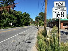
353:View east along MD 168 from I-695 in Linthicum
665:(Map). Baltimore: Maryland Geological Survey.
511:(Baltimore–Annapolis Boulevard) –
301:View west along MD 168 at MD 648 in Linthicum
8:
440:West Nursery Road / Hammonds Ferry Road to
384:
215:
723:
720:Template:Attached KML/Maryland Route 168
676:Maryland State Roads Commission (1939).
576:. Maryland State Highway Administration
557:
749:Roads in Anne Arundel County, Maryland
679:General Highway Map: State of Maryland
289:. MD 168 was built in the late 1920s.
18:
502:
496:
457:
451:
420:
414:
44:Maryland Route 168 highlighted in red
7:
521:Eastern terminus; officially MD 648E
659:Maryland Geological Survey (1930).
397:
14:
540:
503:
471:
465:
459:
434:
428:
422:
236:
221:
116:
100:
66:1.28 mi (2.06 km)
24:
1:
391:
484:Fairview Avenue is unsigned
765:
744:State highways in Maryland
573:Highway Location Reference
547:Maryland Roads portal
525:
520:
499:
491:
483:
454:
446:
417:
409:
404:
401:
396:
390:
387:
214:
179:
170:
131:
54:
42:
37:
344:Baltimore Light RailLink
378:The entire route is in
184:Maryland highway system
87:Hammonds Ferry Road in
354:
302:
352:
300:
265:in the U.S. state of
724:KML is from Wikidata
610:"Maryland Route 168"
336:Nursery Road station
590:Anne Arundel County
517:Baltimore Highlands
477:Fairview Avenue to
380:Anne Arundel County
316:diamond interchange
287:Anne Arundel County
96:Major intersections
355:
303:
255:Maryland Route 168
31:Maryland Route 168
531:
530:
293:Route description
252:
251:
248:
247:
50:Route information
756:
714:
687:
686:
684:
673:
667:
666:
656:
650:
649:
647:
646:
632:
626:
625:
623:
622:
606:
600:
597:
595:
584:
582:
581:
567:
545:
544:
543:
507:
506:
476:
475:
474:
469:
468:
463:
462:
447:Western terminus
439:
438:
437:
432:
431:
426:
425:
399:
393:
385:
244:
240:
239:
229:
225:
224:
216:
120:
119:
104:
103:
97:
28:
19:
764:
763:
759:
758:
757:
755:
754:
753:
734:
733:
729:MDRoads: MD 168
725:
722:
717:
716:
715:
699:
695:
690:
682:
675:
674:
670:
658:
657:
653:
644:
642:
634:
633:
629:
620:
618:
608:
607:
603:
593:
587:
579:
577:
569:
568:
559:
555:
541:
539:
536:
527:
504:
472:
470:
466:
464:
460:
458:
435:
433:
429:
427:
423:
421:
394:
376:
360:
295:
237:
235:
222:
220:
117:
101:
95:
79:Major junctions
45:
33:
32:
29:
17:
12:
11:
5:
762:
760:
752:
751:
746:
736:
735:
732:
731:
698:
697:
696:
694:
693:External links
691:
689:
688:
668:
651:
627:
601:
599:
598:
556:
554:
551:
550:
549:
535:
532:
529:
528:
523:
522:
519:
501:
498:
495:
489:
488:
482:
456:
453:
449:
448:
445:
419:
416:
413:
407:
406:
403:
400:
395:
389:
375:
372:
359:
356:
312:Patapsco River
308:Interstate 695
294:
291:
250:
249:
246:
245:
232:
230:
212:
211:
210:
209:
204:
199:
194:
188:
187:
177:
176:
175:Highway system
172:
171:
168:
167:
162:
158:
157:
152:
148:
147:
142:
138:
137:
133:
132:
129:
128:
114:
110:
109:
98:
92:
91:
85:
81:
80:
76:
75:
72:
68:
67:
64:
60:
59:
55:Maintained by
52:
51:
47:
46:
43:
40:
39:
35:
34:
30:
23:
22:
15:
13:
10:
9:
6:
4:
3:
2:
761:
750:
747:
745:
742:
741:
739:
730:
727:
726:
721:
712:
708:
704:
703:
692:
681:
680:
672:
669:
664:
663:
655:
652:
640:
639:
631:
628:
617:
616:
611:
605:
602:
592:
591:
586:
585:
575:
574:
566:
564:
562:
558:
552:
548:
538:
537:
533:
524:
518:
514:
510:
494:
490:
487:
480:
450:
443:
412:
408:
386:
383:
381:
374:Junction list
373:
371:
369:
365:
357:
351:
347:
345:
341:
337:
332:
329:
325:
321:
317:
313:
309:
299:
292:
290:
288:
284:
280:
276:
272:
268:
264:
263:state highway
260:
256:
243:
233:
231:
228:
218:
217:
213:
208:
207:Scenic Byways
205:
203:
200:
198:
195:
193:
190:
189:
186:
185:
181:
180:
178:
173:
169:
166:
163:
159:
156:
153:
149:
146:
145:United States
143:
139:
134:
130:
127:
123:
115:
113:East end
111:
107:
99:
93:
90:
86:
84:West end
82:
77:
73:
69:
65:
61:
58:
53:
48:
41:
36:
27:
20:
700:
678:
671:
661:
654:
643:. Retrieved
637:
630:
619:. Retrieved
613:
604:
589:
578:. Retrieved
572:
402:Destinations
377:
361:
340:MTA Maryland
304:
285:in northern
271:Nursery Road
270:
258:
254:
253:
182:
165:Anne Arundel
108:in Linthicum
74:1929–present
38:Nursery Road
615:Google Maps
269:. Known as
738:Categories
645:2012-11-29
621:2012-11-29
580:2012-11-17
553:References
192:Interstate
411:Linthicum
275:Linthicum
89:Linthicum
702:KML file
534:See also
513:Ferndale
493:Pumphrey
388:Location
328:unsigned
283:Pumphrey
277:east to
267:Maryland
161:Counties
155:Maryland
136:Location
126:Pumphrey
612:(Map).
486:MD 969A
358:History
331:MD 969A
261:) is a
141:Country
71:Existed
509:MD 648
364:MD 167
320:MD 295
279:MD 648
259:MD 168
242:MD 169
227:MD 166
122:MD 648
63:Length
683:(PDF)
594:(PDF)
479:I-695
442:I-695
405:Notes
318:with
202:State
151:State
106:I-695
57:MDSHA
711:help
707:edit
500:2.06
497:1.28
481:west
455:0.34
452:0.21
444:east
418:0.00
415:0.00
368:MD 3
342:'s
338:of
281:in
124:in
740::
709:•
560:^
515:,
398:km
392:mi
382:.
370:.
346:.
234:→
219:←
197:US
713:)
705:(
648:.
624:.
596:.
583:.
257:(
Text is available under the Creative Commons Attribution-ShareAlike License. Additional terms may apply.