284:
332:). The portion of Armory Road north of MD 402 was designated MD 750. In 1957, the state highway was extended east from Wilson Road to Dares Beach using what is now MD 768. MD 402 was removed from Armory Road the same year when the road was transferred to county control. The state highway was reconstructed with a wider bituminous concrete surface starting in 1957 from the Prince Frederick end. The reconstruction was completed in 1959, the same year the highway was extended to its present western terminus at MD 2. MD 402 was rerouted to its present eastern terminus in 1960.
26:
439:
224:
209:
433:
390:
385:
89:
84:
483:
283:
327:
MD 402 was constructed as a gravel road from MD 2 in Prince
Frederick, which originally followed Armory Road, to Wilson Road near Dares Beach in 1932. When MD 2 was relocated on the north side of Prince Frederick around 1942, MD 402 was extended south along Armory Road to Main Street (then MD 2, now
550:
295:
as
Solomons Island Road, in the northern end of Prince Frederick. The roadway continues west as West Dares Beach Road to Prince Frederick Boulevard. MD 402 heads east as two-lane undivided Dares Beach Road, which intersects Armory Road at a
304:. The state highway passes through a forested area with scattered residential subdivisions. Between Prince Frederick and Dares Beach, MD 402 intersects Wilson Road, which heads north toward
301:
275:. MD 402 was mostly constructed in 1932. Both termini have changed multiple times; the state highway settled into its present routing in the late 1950s.
820:
315:(Dares Wharf Road), splits to the northeast. MD 402 continues east as Branch Street to its eastern terminus at Chesapeake Avenue, one block west of the
749:
729:
685:
665:
645:
601:
791:
177:
51:
815:
187:
182:
192:
372:
268:
100:
409:
341:
150:
169:
259:. Known for most of its length as Dares Beach Road, the state highway runs 4.33 miles (6.97 km) from
305:
487:
419:
272:
111:
512:
405:
443:
401:
329:
312:
292:
227:
212:
603:
Map of
Maryland Showing State Road System: State Aid Roads and Improved County Road Connections
782:
397:
393:
309:
264:
260:
96:
92:
529:
705:
621:
577:
316:
809:
248:
130:
800:
555:
704:
Bonnell, Robert O.; Bennett, Edgar T.; McMullen, John J. (December 15, 1958).
297:
252:
582:(1931–1934 ed.). Baltimore: Maryland State Roads Commission. p. 322
308:. On the western edge of Dares Beach, the old alignment of MD 402, which is
710:(1957–1958 ed.). Baltimore: Maryland State Roads Commission. p. 73
626:(1941–1942 ed.). Baltimore: Maryland State Roads Commission. p. 93
25:
256:
140:
653:(Map) (1946–1947 ed.). Baltimore: Maryland State Roads Commission.
620:
Whitman, Ezra B.; Webb, P. Watson; Thomas, W. Frank (March 15, 1943).
282:
790:
467:
1.000 mi = 1.609 km; 1.000 km = 0.621 mi
511:
Highway
Information Services Division (December 31, 2013).
400:(Solomons Island Road) / West Dares Beach Road –
778:
773:
291:
MD 402 begins at an intersection with MD 2/MD 4, which
576:
Byron, William D.; Lacy, Robert (December 28, 1934).
160:
146:
136:
126:
121:
106:
78:
73:
65:
57:
44:
21:
757:(Map). Baltimore: Maryland State Roads Commission.
737:(Map). Baltimore: Maryland State Roads Commission.
693:(Map). Baltimore: Maryland State Roads Commission.
673:(Map). Baltimore: Maryland State Roads Commission.
707:Report of the State Roads Commission of Maryland
623:Report of the State Roads Commission of Maryland
579:Report of the State Roads Commission of Maryland
506:
504:
502:
609:(Map). Baltimore: Maryland Geological Survey.
8:
346:
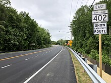
287:View east along MD 402 in Prince Frederick
201:
795:
792:Template:Attached KML/Maryland Route 402
748:Maryland State Roads Commission (1960).
728:Maryland State Roads Commission (1959).
684:Maryland State Roads Commission (1957).
664:Maryland State Roads Commission (1950).
644:Maryland State Roads Commission (1946).
16:State highway in Maryland, United States
517:. Maryland State Highway Administration
498:
18:
458:
452:
429:
423:
382:
376:
39:Maryland Route 402 highlighted in red
7:
600:Maryland Geological Survey (1933).
359:
14:
821:Roads in Calvert County, Maryland
481:
437:
431:
388:
383:
222:
207:
87:
82:
61:4.33 mi (6.97 km)
24:
751:Maryland: Official Highway Map
731:Maryland: Official Highway Map
687:Maryland: Official Highway Map
667:Maryland: Official Highway Map
647:Maryland: Official Highway Map
1:
353:
271:east to Chesapeake Avenue in
837:
816:State highways in Maryland
514:Highway Location Reference
488:Maryland Roads portal
466:
461:
455:
448:
426:
418:
413:
379:
371:
366:
363:
358:
352:
349:
200:
165:
156:
117:
49:
37:
446:north (Dares Wharf Road)
340:The entire route is in
170:Maryland highway system
288:
286:
110:Chesapeake Avenue in
796:KML is from Wikidata
551:"Maryland Route 402"
300:and passes south of
302:Calvert High School
289:
241:Maryland Route 402
31:Maryland Route 402
472:
471:
459:Chesapeake Avenue
279:Route description
238:
237:
234:
233:
45:Route information
828:
786:
759:
758:
756:
745:
739:
738:
736:
725:
719:
718:
716:
715:
701:
695:
694:
692:
681:
675:
674:
672:
661:
655:
654:
652:
641:
635:
634:
632:
631:
617:
611:
610:
608:
597:
591:
590:
588:
587:
573:
567:
566:
564:
563:
547:
541:
538:
536:
525:
523:
522:
508:
486:
485:
484:
462:Eastern terminus
442:
441:
440:
435:
434:
414:Western terminus
392:
391:
387:
386:
373:Prince Frederick
361:
355:
347:
293:run concurrently
269:Prince Frederick
230:
226:
225:
215:
211:
210:
202:
101:Prince Frederick
91:
90:
86:
85:
28:
19:
836:
835:
831:
830:
829:
827:
826:
825:
806:
805:
801:MDRoads: MD 402
797:
794:
789:
788:
787:
771:
767:
762:
754:
747:
746:
742:
734:
727:
726:
722:
713:
711:
703:
702:
698:
690:
683:
682:
678:
670:
663:
662:
658:
650:
643:
642:
638:
629:
627:
619:
618:
614:
606:
599:
598:
594:
585:
583:
575:
574:
570:
561:
559:
549:
548:
544:
534:
528:
520:
518:
510:
509:
500:
496:
482:
480:
477:
468:
438:
436:
432:
430:
389:
384:
356:
338:
325:
281:
223:
221:
208:
206:
88:
83:
74:Major junctions
40:
33:
32:
29:
17:
12:
11:
5:
834:
832:
824:
823:
818:
808:
807:
804:
803:
770:
769:
768:
766:
765:External links
763:
761:
760:
740:
720:
696:
676:
656:
636:
612:
592:
568:
542:
540:
539:
531:Calvert County
497:
495:
492:
491:
490:
476:
473:
470:
469:
464:
463:
460:
457:
454:
450:
449:
447:
428:
425:
422:
416:
415:
412:
410:Upper Marlboro
381:
378:
375:
369:
368:
365:
362:
357:
351:
342:Calvert County
337:
334:
324:
321:
317:Chesapeake Bay
280:
277:
236:
235:
232:
231:
218:
216:
198:
197:
196:
195:
190:
185:
180:
174:
173:
163:
162:
161:Highway system
158:
157:
154:
153:
148:
144:
143:
138:
134:
133:
128:
124:
123:
119:
118:
115:
114:
108:
104:
103:
80:
76:
75:
71:
70:
67:
63:
62:
59:
55:
54:
50:Maintained by
47:
46:
42:
41:
38:
35:
34:
30:
23:
22:
15:
13:
10:
9:
6:
4:
3:
2:
833:
822:
819:
817:
814:
813:
811:
802:
799:
798:
793:
784:
780:
776:
775:
764:
753:
752:
744:
741:
733:
732:
724:
721:
709:
708:
700:
697:
689:
688:
680:
677:
669:
668:
660:
657:
649:
648:
640:
637:
625:
624:
616:
613:
605:
604:
596:
593:
581:
580:
572:
569:
558:
557:
552:
546:
543:
533:
532:
527:
526:
516:
515:
507:
505:
503:
499:
493:
489:
479:
478:
474:
465:
451:
445:
421:
417:
411:
407:
403:
399:
395:
374:
370:
348:
345:
343:
336:Junction list
335:
333:
331:
322:
320:
318:
314:
311:
307:
303:
299:
294:
285:
278:
276:
274:
270:
266:
262:
258:
254:
250:
249:state highway
246:
242:
229:
219:
217:
214:
204:
203:
199:
194:
193:Scenic Byways
191:
189:
186:
184:
181:
179:
176:
175:
172:
171:
167:
166:
164:
159:
155:
152:
149:
145:
142:
139:
135:
132:
131:United States
129:
125:
120:
116:
113:
109:
107:East end
105:
102:
98:
94:
81:
79:West end
77:
72:
68:
64:
60:
56:
53:
48:
43:
36:
27:
20:
772:
750:
743:
730:
723:
712:. Retrieved
706:
699:
686:
679:
666:
659:
646:
639:
628:. Retrieved
622:
615:
602:
595:
584:. Retrieved
578:
571:
560:. Retrieved
554:
545:
530:
519:. Retrieved
513:
364:Destinations
339:
326:
290:
244:
240:
239:
168:
69:1932–present
556:Google Maps
420:Dares Beach
319:shoreline.
273:Dares Beach
112:Dares Beach
810:Categories
714:2011-02-17
630:2011-02-17
586:2011-02-17
562:2011-02-17
521:2011-02-17
494:References
306:Plum Point
298:roundabout
253:U.S. state
178:Interstate
406:Annapolis
774:KML file
475:See also
402:Solomons
396: /
350:Location
310:unsigned
257:Maryland
147:Counties
141:Maryland
122:Location
95: /
553:(Map).
323:History
251:in the
247:) is a
151:Calvert
127:Country
66:Existed
444:MD 768
330:MD 765
313:MD 768
245:MD 402
228:MD 404
213:MD 396
58:Length
755:(PDF)
735:(PDF)
691:(PDF)
671:(PDF)
651:(PDF)
607:(PDF)
535:(PDF)
367:Notes
188:State
137:State
52:MDSHA
783:help
779:edit
456:6.97
453:4.33
427:6.20
424:3.85
398:MD 4
394:MD 2
380:0.00
377:0.00
265:MD 4
261:MD 2
97:MD 4
93:MD 2
267:in
255:of
99:in
812::
781:•
501:^
408:,
404:,
360:km
354:mi
344:.
220:→
205:←
183:US
785:)
777:(
717:.
633:.
589:.
565:.
537:.
524:.
263:/
243:(
Text is available under the Creative Commons Attribution-ShareAlike License. Additional terms may apply.