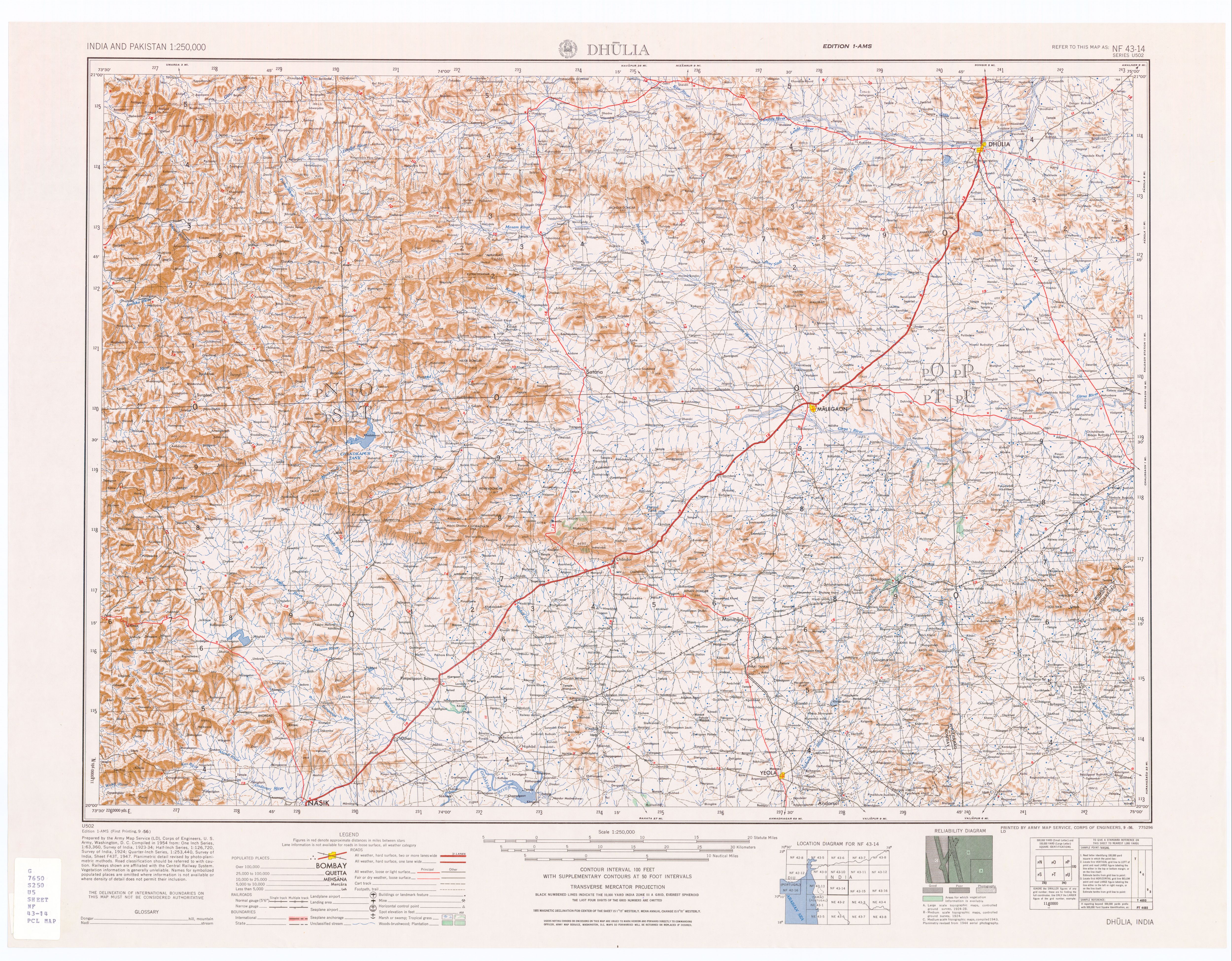
64:, with Vide Digar on the right bank (south) and Jaitapur on the left bank (north). It continues east past Antapur to Taharabad where it turns northeast up to Sompur where it turns southeast, and it continues southeast past
266:
220:
295:
290:
138:
130:
285:
259:
213:
83:
300:
252:
206:
134:
236:
190:
178:
29:
153:
73:
57:
279:
61:
53:
49:
182:
37:
33:
98:
85:
77:
65:
69:
186:
161:, Series U-502, United States Army Map Service, September 1956
56:, in northern Nashik District, just south of the border with
240:
194:
139:
United States
National Geospatial-Intelligence Agency
235:This article related to a river in India is a
148:
146:
260:
214:
8:
267:
253:
221:
207:
60:. The river flows east and is dammed at
120:
36:, India. It is a left tributary of the
126:
124:
76:and then turns south into the city of
7:
232:
230:
174:
172:
239:. You can help Knowledge (XXG) by
193:. You can help Knowledge (XXG) by
159:(topographic map, scale 1:250,000)
80:where it joins the Girna River at
14:
296:Nashik Division geography stubs
52:, above the village of Golwad,
291:Tributaries of the Tapti River
48:The Mosam River arises in the
1:
155:Dhulia, India, Sheet NF 43-14
317:
229:
171:
189:location article is a
131:Mosam River (Approved)
286:Rivers of Maharashtra
99:20.53083°N 74.53278°E
135:GEOnet Names Server
95: /
104:20.53083; 74.53278
301:India river stubs
248:
247:
202:
201:
26:Mokshaganga River
308:
269:
262:
255:
231:
223:
216:
209:
173:
163:
162:
160:
150:
141:
128:
110:
109:
107:
106:
105:
100:
96:
93:
92:
91:
88:
28:) is a river in
316:
315:
311:
310:
309:
307:
306:
305:
276:
275:
274:
273:
228:
227:
179:Nashik district
169:
167:
166:
158:
152:
151:
144:
129:
122:
117:
103:
101:
97:
94:
89:
86:
84:
82:
81:
46:
30:Nashik District
12:
11:
5:
314:
312:
304:
303:
298:
293:
288:
278:
277:
272:
271:
264:
257:
249:
246:
245:
226:
225:
218:
211:
203:
200:
199:
165:
164:
142:
119:
118:
116:
113:
58:Dhule District
45:
42:
13:
10:
9:
6:
4:
3:
2:
313:
302:
299:
297:
294:
292:
289:
287:
284:
283:
281:
270:
265:
263:
258:
256:
251:
250:
244:
242:
238:
233:
224:
219:
217:
212:
210:
205:
204:
198:
196:
192:
188:
184:
180:
175:
170:
157:
156:
149:
147:
143:
140:
136:
132:
127:
125:
121:
114:
112:
108:
79:
75:
71:
67:
63:
62:Haranbari Dam
59:
55:
54:Baglan Taluka
51:
50:Western Ghats
43:
41:
39:
35:
31:
27:
23:
19:
241:expanding it
234:
195:expanding it
176:
168:
154:
47:
25:
21:
18:Mausam River
17:
15:
183:Maharashtra
102: /
90:074°31′58″E
38:Girna River
34:Maharashtra
22:Mosam River
280:Categories
87:20°31′51″N
78:Malegaon
66:Jaikheda
74:Kashti
72:, and
70:Nampur
44:Course
187:India
177:This
115:Notes
237:stub
191:stub
16:The
133:at
32:in
282::
185:,
181:,
145:^
137:,
123:^
111:.
68:,
40:.
24:,
268:e
261:t
254:v
243:.
222:e
215:t
208:v
197:.
20:(
Text is available under the Creative Commons Attribution-ShareAlike License. Additional terms may apply.