45:
334:
29:
164:
52:
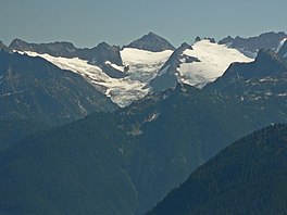
190:. The glacier is approximately 1.85 mi (2.98 km) in length, 1.5 mi (2.4 km) in width at its terminus and descends from 8,000 to 4,500 ft (2,400 to 1,400 m), where it terminates near a
379:
403:
44:
214:
to the east. Like most glaciers in the North
Cascades, McAllister Glacier is retreating and retreated approximately 1350 ft (410 m) between 1975 and 2009.
413:
106:
257:
408:
398:
372:
223:
248:
303:
365:
253:
280:
183:
99:
84:
88:
243:
195:
203:
345:
187:
333:
349:
211:
191:
28:
392:
207:
179:
92:
163:
210:
and an arete extending north from that peak separate McAllister
Glacier from the
121:
108:
199:
341:
175:
162:
353:
285:(Map). TopoQwest (United States Geological Survey Maps)
198:
to the south and the two glaciers are separated by the
153:
145:
137:
98:
80:
72:
21:
373:
8:
304:"McAllister Glacier Retreat, North Cascades"
194:. McAllister Glacier is nearly connected to
380:
366:
51:
18:
258:United States Department of the Interior
235:
275:
273:
404:Glaciers of Skagit County, Washington
224:List of glaciers in the United States
7:
330:
328:
249:Geographic Names Information System
352:. You can help Knowledge (XXG) by
16:Glacier in the state of Washington
14:
414:Washington (state) glacier stubs
332:
50:
43:
27:
254:United States Geological Survey
409:Glaciers of Washington (state)
399:Glaciers of the North Cascades
1:
308:From a Glacier's Perspective
184:North Cascades National Park
85:North Cascades National Park
141:1.85 mi (2.98 km)
430:
327:
33:McAllister Glacier in 2007
178:to the north and east of
89:Skagit County, Washington
38:
26:
186:, in the U.S. state of
168:
122:48.55667°N 121.13028°W
64:Location in Washington
340:This article about a
166:
244:"McAllister Glacier"
127:48.55667; -121.13028
196:Inspiration Glacier
118: /
172:McAllister Glacier
169:
167:McAllister Glacier
58:McAllister Glacier
22:McAllister Glacier
361:
360:
282:Eldorado Peak, WA
161:
160:
421:
382:
375:
368:
336:
329:
319:
318:
316:
315:
300:
294:
293:
291:
290:
277:
268:
267:
265:
264:
240:
212:Klawatti Glacier
133:
132:
130:
129:
128:
123:
119:
116:
115:
114:
111:
76:Mountain glacier
54:
53:
47:
31:
19:
429:
428:
424:
423:
422:
420:
419:
418:
389:
388:
387:
386:
325:
323:
322:
313:
311:
302:
301:
297:
288:
286:
279:
278:
271:
262:
260:
242:
241:
237:
232:
220:
192:proglacial lake
126:
124:
120:
117:
112:
109:
107:
105:
104:
68:
67:
66:
65:
62:
61:
60:
59:
55:
34:
17:
12:
11:
5:
427:
425:
417:
416:
411:
406:
401:
391:
390:
385:
384:
377:
370:
362:
359:
358:
337:
321:
320:
295:
269:
234:
233:
231:
228:
227:
226:
219:
216:
174:is in a large
159:
158:
155:
151:
150:
147:
143:
142:
139:
135:
134:
102:
96:
95:
82:
78:
77:
74:
70:
69:
63:
57:
56:
49:
48:
42:
41:
40:
39:
36:
35:
32:
24:
23:
15:
13:
10:
9:
6:
4:
3:
2:
426:
415:
412:
410:
407:
405:
402:
400:
397:
396:
394:
383:
378:
376:
371:
369:
364:
363:
357:
355:
351:
347:
343:
338:
335:
331:
326:
309:
305:
299:
296:
284:
283:
276:
274:
270:
259:
255:
251:
250:
245:
239:
236:
229:
225:
222:
221:
217:
215:
213:
209:
208:Klawatti Peak
205:
201:
197:
193:
189:
185:
181:
180:Dorado Needle
177:
173:
165:
156:
152:
148:
144:
140:
136:
131:
103:
101:
97:
94:
90:
86:
83:
79:
75:
71:
46:
37:
30:
25:
20:
354:expanding it
339:
324:
312:. Retrieved
310:. 2011-12-11
307:
298:
287:. Retrieved
281:
261:. Retrieved
247:
238:
204:Tepeh Towers
171:
170:
125: /
113:121°07′49″W
100:Coordinates
393:Categories
346:Washington
314:2022-03-05
289:2013-02-09
263:2013-02-09
230:References
188:Washington
157:Retreating
110:48°33′24″N
202:known as
218:See also
146:Terminus
81:Location
342:glacier
149:Icefall
176:cirque
154:Status
138:Length
348:is a
200:arête
350:stub
93:U.S.
73:Type
344:in
395::
306:.
272:^
256:,
252:.
246:.
206:.
182:,
91:,
87:,
381:e
374:t
367:v
356:.
317:.
292:.
266:.
Text is available under the Creative Commons Attribution-ShareAlike License. Additional terms may apply.