415:
begun to decline once again. As of July 2023, Medina Lake was the lowest it’s been since 2015, only being filled to about 5% capacity, compared to 12% capacity in 2022. This is due to constant drought and irrigation as many experts claim it may take years of rain to replenish the reservoir. Due to declining lake levels, many area farmers have to turned to using groundwater for irrigation. In June 2024, Medina Lake had dropped down to 2.4% capacity, with
Lakehills and the surrounding areas suffering an
83:
53:
400:, the lake water levels dropped below 5% capacity. Many cracks, oil drums and a Jeep were visible as a result of low water. Only one public boat ramp remained, located at Red Cove in Mico. A few showers in the Summer of 2013 helped the lake rise to 5.2%, but the dam was reopened in September as many people in the South Side of San Antonio use the lake for a water source. Many businesses have closed in the area, many residents have left and
36:
90:
60:
114:
414:
Due to heavy rains on the Medina River basin and the lake itself in May 2016, Medina Lake was 100% full and 1.5 feet above its conservation pool as of June 1, 2016. As of July 2024, the last time the lake was considered to be at full capacity was on July 7, 2019. Since then, the lake levels have
388:. Due to drought conditions lasting up until July 2015, recreational fish species had disappeared. Plans to restock the lake once levels reach viable levels were put in place. These plans were realized when the lake did reach these levels, which as of October 2, 2016, is 96.6% full.
436:
695:
411:
Heavy rainfall in the region as of May 2015 brought the levels above 46% capacity. At that time, Medina Lake was about 28 feet low, down from 90 feet low mere months before.
337:
at the lake's south end. At the time of the dam's construction, it was the largest concrete dam in the country and the fourth largest dam overall. The dam is listed on the
734:
739:
523:
574:
397:
440:
149:
549:
82:
368:
Medina Lake has been stocked with species of fish intended to improve the reservoir for recreational fishing. Fish in Medina Lake include
338:
645:
333:
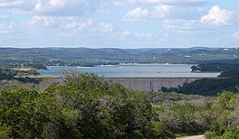
running west to east. It is 18 miles (29 km) long and 3 miles (5 km) wide at its broadest point. It is contained by the
52:
729:
527:
578:
353:
315:
239:
210:
127:
311:
131:
416:
377:
319:
295:
196:
622:
274:
462:
672:
600:
498:
476:
401:
357:
348:, and serves both recreational and irrigation uses. Communities located along the lake are
369:
224:
723:
299:
345:
306:
was completed in 1913 in a privately financed project, creating the lake to supply
291:
217:
203:
349:
186:
17:
113:
35:
405:
373:
334:
307:
303:
302:. It is operated by the Bexar/Medina/Atascosa County Agricultural District.
164:
151:
330:
287:
189:
419:
as a result along with depreciated home values and a rise in homelessness.
696:"Medina Lake at historic low water levels, also causing economic drought"
326:
699:
381:
197:
211:
310:
water for local agricultural use. Lake Medina is in northeastern
135:
646:"Medina Lake is still shrinking. Here's why, and why it matters"
385:
181:
575:"Lakehills 'a ghost town': Is Medina Lake fish kill imminent"
437:"Medina Lake's rich fishing history now only a memory"
264:
256:
248:
238:
234:
223:
209:
195:
180:
141:
123:
28:
644:
499:"Rainfall barely can slow decline of Medina Lake"
344:The lake is fed by and discharges back into the
142:
550:"Residents on edge as Medina Lake evaporates"
8:
318:, about 40 miles (64 km) northwest of
25:
735:Bodies of water of Bandera County, Texas
740:Bodies of water of Medina County, Texas
428:
398:2010–13 Southern United States drought
694:Esquivel, Stephanie (June 13, 2024).
7:
577:. Kens 5 San Antonio. Archived from
339:National Register of Historic Places
524:"Medina Lake nears 1968 record low"
89:
59:
23:Agricultural reservoir in Texas, US
526:. Bandera Bulletin. Archived from
14:
112:
88:
81:
58:
51:
34:
263:
255:
247:
237:
1:
439:. KSAT ABC 12. Archived from
122:
102:Show map of the United States
392:Future and state of the lake
244:6,060 acres (2,450 ha)
756:
275:not a well-defined measure
268:1,062 ft (324 m)
15:
404:has become somewhat of a
272:
260:110 mi (180 km)
111:
45:
33:
651:San Antonio Express News
554:San Antonio Express News
503:San Antonio Express News
252:152 ft (46 m)
675:. Water Data for Texas
625:. Water Data for Texas
603:. Water Data for Texas
479:. Water Data for Texas
463:"Water Data for Texas"
165:29.54028°N 98.93361°W
730:Reservoirs in Texas
653:. February 29, 2024
417:economic depression
378:hybrid striped bass
170:29.54028; -98.93361
161: /
581:on January 4, 2014
354:Lake Medina Shores
296:Texas Hill Country
16:For the band, see
443:on August 9, 2015
314:and southeastern
281:
280:
265:Surface elevation
72:Show map of Texas
747:
711:
710:
708:
706:
691:
685:
684:
682:
680:
669:
663:
662:
660:
658:
648:
641:
635:
634:
632:
630:
619:
613:
612:
610:
608:
597:
591:
590:
588:
586:
571:
565:
564:
562:
560:
546:
540:
539:
537:
535:
530:on March 5, 2015
520:
514:
513:
511:
509:
495:
489:
488:
486:
484:
473:
467:
466:
459:
453:
452:
450:
448:
433:
364:Fish populations
273:Shore length is
213:
212:Primary outflows
199:
176:
175:
173:
172:
171:
166:
162:
159:
158:
157:
154:
144:
116:
103:
92:
91:
85:
73:
62:
61:
55:
38:
26:
755:
754:
750:
749:
748:
746:
745:
744:
720:
719:
717:
715:
714:
704:
702:
693:
692:
688:
678:
676:
671:
670:
666:
656:
654:
643:
642:
638:
628:
626:
621:
620:
616:
606:
604:
599:
598:
594:
584:
582:
573:
572:
568:
558:
556:
548:
547:
543:
533:
531:
522:
521:
517:
507:
505:
497:
496:
492:
482:
480:
475:
474:
470:
461:
460:
456:
446:
444:
435:
434:
430:
425:
396:As part of the
394:
370:largemouth bass
366:
227: countries
198:Primary inflows
169:
167:
163:
160:
155:
152:
150:
148:
147:
119:
107:
106:
105:
104:
101:
100:
99:
98:
97:
93:
76:
75:
74:
71:
70:
69:
68:
67:
63:
41:
24:
21:
12:
11:
5:
753:
751:
743:
742:
737:
732:
722:
721:
713:
712:
686:
664:
636:
614:
592:
566:
541:
515:
490:
468:
454:
427:
426:
424:
421:
393:
390:
365:
362:
316:Bandera County
279:
278:
270:
269:
266:
262:
261:
258:
254:
253:
250:
246:
245:
242:
236:
235:
232:
231:
228:
221:
220:
215:
207:
206:
201:
193:
192:
184:
178:
177:
145:
139:
138:
125:
121:
120:
117:
109:
108:
95:
94:
87:
86:
80:
79:
78:
77:
65:
64:
57:
56:
50:
49:
48:
47:
46:
43:
42:
39:
31:
30:
22:
13:
10:
9:
6:
4:
3:
2:
752:
741:
738:
736:
733:
731:
728:
727:
725:
718:
701:
697:
690:
687:
674:
673:"Medina Lake"
668:
665:
652:
647:
640:
637:
624:
623:"Medina Lake"
618:
615:
602:
601:"Medina Lake"
596:
593:
580:
576:
570:
567:
555:
551:
545:
542:
529:
525:
519:
516:
504:
500:
494:
491:
478:
477:"Medina Lake"
472:
469:
464:
458:
455:
442:
438:
432:
429:
422:
420:
418:
412:
409:
407:
403:
399:
391:
389:
387:
383:
379:
375:
371:
363:
361:
359:
355:
351:
347:
342:
340:
336:
332:
328:
323:
321:
317:
313:
312:Medina County
309:
305:
301:
300:United States
297:
293:
289:
285:
276:
271:
267:
259:
251:
243:
241:
233:
230:United States
229:
226:
222:
219:
216:
214:
208:
205:
202:
200:
194:
191:
188:
185:
183:
179:
174:
146:
140:
137:
133:
129:
126:
115:
110:
84:
54:
44:
37:
32:
27:
19:
716:
703:. Retrieved
689:
677:. Retrieved
667:
655:. Retrieved
650:
639:
627:. Retrieved
617:
605:. Retrieved
595:
583:. Retrieved
579:the original
569:
557:. Retrieved
553:
544:
532:. Retrieved
528:the original
518:
506:. Retrieved
502:
493:
481:. Retrieved
471:
457:
445:. Retrieved
441:the original
431:
413:
410:
395:
367:
346:Medina River
343:
324:
292:Medina River
283:
282:
257:Shore length
240:Surface area
218:Medina River
204:Medina River
187:Agricultural
320:San Antonio
284:Medina Lake
168: /
143:Coordinates
96:Medina Lake
66:Medina Lake
40:Medina Lake
29:Medina Lake
18:Madina Lake
724:Categories
585:January 4,
559:January 4,
534:January 4,
508:January 4,
423:References
406:ghost town
374:white bass
335:Medina Dam
308:irrigation
304:Medina Dam
249:Max. depth
156:98°56′01″W
153:29°32′25″N
134:counties,
402:Lakehills
358:Lakehills
331:reservoir
288:reservoir
190:reservoir
182:Lake type
136:Texas, US
705:July 28,
679:July 16,
657:July 28,
329:-shaped
327:crescent
325:It is a
124:Location
700:WOAI-TV
629:June 3,
607:May 25,
483:May 25,
447:May 25,
382:catfish
298:of the
294:in the
290:on the
128:Bandera
384:, and
132:Medina
286:is a
225:Basin
707:2024
681:2023
659:2024
631:2016
609:2015
587:2014
561:2014
536:2014
510:2014
485:2015
449:2015
386:carp
356:and
350:Mico
118:Map
726::
698:.
649:.
552:.
501:.
408:.
380:,
376:,
372:,
360:.
352:,
341:.
322:.
130:/
709:.
683:.
661:.
633:.
611:.
589:.
563:.
538:.
512:.
487:.
465:.
451:.
277:.
20:.
Text is available under the Creative Commons Attribution-ShareAlike License. Additional terms may apply.