376:
44:
60:
456:
1227:
447:
eroded by streams that run on either side. A Dr Phenè discovered this structure and excavations revealed a paved platform shaped like a segment of a circle, together with many bones and charcoal. As stated, the mound itself may well be entirely natural; however, the paved platform is a genuine artifact; it is not listed by the relevant authorities.
67:
181:
438:, etc. With the establishment of the coast road a new bridge was built over the Skelmorlie Water and the old bridge and that section of the old road became an entrance to Bridgend House. The 1832 Thomson's map shows the new coastal toll road with a new bridge at Meagle (sic) named Haining Bridge End.
446:
Above the hamlet lies the 'Serpent Mound', named after the curved shape of the earthwork. It is said to have been had connections with the cult of sun worship. Smith records that despite the serpentine shape it is a natural stratified structure formed from stratified deposits on the old raised beach
397:
In 1855 a new road had been built close to the coast and
Bridgend House and its grounds stand on the old toll road route. A bathing house is shown on the north side of the Skelmorlie Burn with a footpath leading to it. A school is also shown on the outskirts of the hamlet that served Meigle and the
393:
In 1876 a chapel was built, using the medium of mass concrete, as a gift from the
Stewart sisters of Ashcraig House. It was converted and extended to become a private dwelling. A mission hall is shown on the OS map of 1909.
401:
In 1909 the post office is no longer shown on OS maps, but a letter box is present as it still is. The school is also not indicated, however the boat house is marked. A mission hall is however still present.
344:
and glen lie nearby. The Meigle Burn has its confluence with the
Skelmorlie Burns to the east of Skelmorlie Bridge. The modern spelling 'Meigle' will be used for consistency. There is also a village called
483:
that has links with the
Scandinavian influences that are common on the west coast of Scotland, is thought to be derived from the Norse ' mjo gil' meaning 'narrow gill' or 'narrow opening'.
239:
383:
Meagle (sic) was an ordinary country school without an endowment, its costs being covered by voluntary
Contributions and by the pupils parents. In 1855-57 Mr Lorgan was the teacher.
221:
1184:
229:
1199:
1194:
247:
205:
98:
590:
579:
568:
1179:
491:
One of the markers for the 'Arran
Measured Mile' is located on the beach at Meigle. In the 19th century a boat house and bathing houses were located here.
463:
Ashcraig House on the Firth of Clyde had a boat house and a bathing house. Spacious formal gardens are overlooked by a circa 1840 pink stone marine villa.
280:
778:
368:
gives the spelling as 'Meagle'. In 1855-57 Meagle (sic) consisted of a cottage house and buildings leased by the late A.H.Campbell Esq from the
59:
1253:
193:
1248:
736:
613:
361:
In the 1750s a mill stood close to the Meigle Burn and
Skelmorlie Water, the mills presence surviving as the place-name 'Millburn'.
1213:
265:
198:
554:
543:
518:
332:
and is named after the bay where the
Skelmorlie Burn flows into the Firth of Clyde. Meigle once stood on the old toll road from
143:
375:
125:
91:
771:
43:
1023:
968:
270:
210:
978:
928:
913:
953:
888:
426:
on its eastern side, crossing a rather narrow Bridge over
Skelmorlie Water and then running further inland via
157:
107:
390:. It was a famous haunt of smugglers who found safe hiding places here in the Rocks, Caves and neighbourhood.
1258:
943:
764:
873:
816:
435:
811:
455:
325:
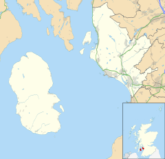
529:
591:
Records
Ordnance Survey Name Books Ayrshire OS Name Books, 1855-1857 Ayrshire volume 42 OS1/3/42/32
427:
133:
350:
1156:
1003:
973:
732:
609:
476:
423:
387:
341:
1232:
1081:
369:
365:
186:
1086:
1051:
918:
787:
480:
321:
115:
80:
28:
1242:
1146:
1076:
1071:
1038:
846:
1131:
898:
1136:
1091:
1008:
963:
958:
878:
1222:
1028:
1018:
903:
841:
826:
386:
Meigle Bay is a small and shallow and lies in the Firth of Clyde in front of
295:
282:
1101:
1046:
993:
948:
938:
923:
908:
836:
821:
801:
167:
744:
Skelmorlie. The Story of the Parish Consisting of Skelmorlie and Wemyss Bay
1126:
1121:
1111:
983:
933:
419:
415:
337:
329:
149:
1106:
1096:
1066:
1061:
1056:
1013:
988:
893:
1116:
883:
472:
346:
655:
628:
479:
may be from the Old English for 'midge gill'. The Meigle hamlet in
831:
806:
454:
431:
411:
374:
333:
756:
760:
746:. Published by The Skelmorlie and Wemyss Bay Community Centre.
629:
Ayrshire I.11 (Largs) Publication date:1910 Revised:1909
328:, Scotland. The settlement lies close to the road to
715:
The Buildings of Scotland : Ayrshire and Arran.
644:
The Buildings of Scotland : Ayrshire and Arran.
1169:
1145:
1037:
866:
855:
794:
340:. It lies 41 m (135 ft) above sea level.
238:
220:
204:
192:
180:
166:
156:
142:
124:
106:
90:
23:
519:Ayrshire, Sheet I, Surveyed: 1855, Published: 1857
772:
555:Rothesay (29), Revised: 1895, Published: 1897
8:
646:London : Yale University Press. p. 539.
863:
779:
765:
757:
20:
504:
219:
175:
165:
141:
89:
40:
656:John Thomson's Atlas of Scotland, 1832
724:. Dundee : Valentine & Sons.
638:
636:
514:
512:
510:
508:
237:
203:
191:
179:
155:
123:
105:
7:
729:Ayrshire : Discovering a County
717:London : Yale University Press.
713:Close, Rob and Riches, Anne (2012).
642:Close, Rob and Riches, Anne (2012).
624:
622:
606:Ayrshire : Discovering a County
600:
598:
564:
562:
539:
537:
422:used to run mainly inland, close to
670:. London : Elliot Stock. p.1.
320:is a hamlet on the Meigle Burn in
14:
580:Ayrshire OS Name Book. Volume 42.
569:Ayrshire OS Name Book. Volume 42.
1225:
1214:List of places in North Ayrshire
530:OS Survey Meigle, North Ayrshire
65:
58:
42:
410:The old road in the 1750s from
731:. Ayr : Fort Publishing.
608:. Ayr : Fort Publishing.
66:
1:
753:. London : Elliot Stock.
18:Human settlement in Scotland
751:Prehistoric Man in Ayrshire
697:Johnston, James B. (1934).
668:Prehistoric Man in Ayrshire
92:OS grid reference
1275:
1254:Villages in North Ayrshire
296:55.85240173°N 4.88388064°W
1249:History of North Ayrshire
1210:
701:London:John Murray. p.250
256:
216:
176:
53:
41:
1185:North Ayrshire and Arran
699:Place-Names of Scotland.
301:55.85240173; -4.88388064
240:Scottish Parliament
230:North Ayrshire and Arran
459:The Victorian letterbox
32:
742:Smart, Walter (1968).
460:
380:
379:The old Meigle Chapel.
458:
378:
126:Lieutenancy area
1191:Scottish Parliament
749:Smith, John (1895).
722:Picturesque Ayrshire
666:Smith, John (1895).
158:Sovereign state
48:The hamlet of Meigle
727:Love, Dane (2003).
604:Love, Dane (2003).
398:surrounding farms.
351:Perth & Kinross
292: /
461:
381:
222:UK Parliament
134:Ayrshire and Arran
1220:
1219:
1200:Cunninghame South
1195:Cunninghame North
1165:
1164:
1004:Meikle Auchengree
974:Hessilhead hamlet
720:Harvey, William.
477:Perth and Kinross
442:The Serpent Mound
424:Skelmorlie Castle
388:Skelmorlie Castle
342:Skelmorlie Castle
311:
310:
248:Cunninghame North
108:Council area
1266:
1235:
1230:
1229:
1228:
1180:Central Ayrshire
864:
781:
774:
767:
758:
702:
695:
689:
686:
680:
677:
671:
664:
658:
653:
647:
640:
631:
626:
617:
602:
593:
588:
582:
577:
571:
566:
557:
552:
546:
541:
532:
527:
521:
516:
307:
306:
304:
303:
302:
297:
293:
290:
289:
288:
285:
262:
152:
102:
101:
79:Location within
69:
68:
62:
46:
21:
1274:
1273:
1269:
1268:
1267:
1265:
1264:
1263:
1239:
1238:
1233:Scotland portal
1231:
1226:
1224:
1221:
1216:
1206:
1161:
1148:
1141:
1033:
859:
857:
851:
790:
785:
705:
696:
692:
687:
683:
679:Harvey, Page 95
678:
674:
665:
661:
654:
650:
641:
634:
627:
620:
603:
596:
589:
585:
578:
574:
567:
560:
553:
549:
542:
535:
528:
524:
517:
506:
497:
489:
471:The place-name
469:
453:
444:
408:
370:Earl of Glasgow
359:
300:
298:
294:
291:
286:
283:
281:
279:
278:
277:
260:
252:
234:
148:
138:
120:
97:
96:
86:
85:
84:
83:
77:
76:
75:
74:
70:
49:
37:
19:
12:
11:
5:
1272:
1270:
1262:
1261:
1259:Firth of Clyde
1256:
1251:
1241:
1240:
1237:
1236:
1218:
1217:
1211:
1208:
1207:
1205:
1204:
1203:
1202:
1197:
1189:
1188:
1187:
1182:
1176:UK Parliament
1173:
1171:
1170:Constituencies
1167:
1166:
1163:
1162:
1160:
1159:
1153:
1151:
1143:
1142:
1140:
1139:
1134:
1129:
1124:
1119:
1114:
1109:
1104:
1099:
1094:
1089:
1084:
1079:
1074:
1069:
1064:
1059:
1054:
1052:Blackwaterfoot
1049:
1043:
1041:
1035:
1034:
1032:
1031:
1026:
1021:
1016:
1011:
1006:
1001:
996:
991:
986:
981:
976:
971:
966:
961:
956:
951:
946:
941:
936:
931:
926:
921:
919:Cunninghamhead
916:
911:
906:
901:
896:
891:
886:
881:
876:
870:
868:
861:
853:
852:
850:
849:
844:
839:
834:
829:
824:
819:
814:
809:
804:
798:
796:
792:
791:
788:North Ayrshire
786:
784:
783:
776:
769:
761:
755:
754:
747:
740:
725:
718:
710:
709:
704:
703:
690:
681:
672:
659:
648:
632:
618:
594:
583:
572:
558:
547:
533:
522:
503:
502:
501:
496:
493:
488:
485:
481:North Ayrshire
468:
465:
452:
451:Ashcraig House
449:
443:
440:
407:
404:
358:
355:
322:North Ayrshire
309:
308:
276:
275:
273:
268:
263:
261:List of places
257:
254:
253:
251:
250:
244:
242:
236:
235:
233:
232:
226:
224:
218:
217:
214:
213:
208:
202:
201:
196:
190:
189:
184:
178:
177:
174:
173:
170:
164:
163:
162:United Kingdom
160:
154:
153:
146:
140:
139:
137:
136:
130:
128:
122:
121:
119:
118:
116:North Ayrshire
112:
110:
104:
103:
94:
88:
87:
81:North Ayrshire
78:
72:
71:
64:
63:
57:
56:
55:
54:
51:
50:
47:
39:
38:
36:
35:
25:
17:
13:
10:
9:
6:
4:
3:
2:
1271:
1260:
1257:
1255:
1252:
1250:
1247:
1246:
1244:
1234:
1223:
1215:
1209:
1201:
1198:
1196:
1193:
1192:
1190:
1186:
1183:
1181:
1178:
1177:
1175:
1174:
1172:
1168:
1158:
1155:
1154:
1152:
1150:
1144:
1138:
1135:
1133:
1130:
1128:
1125:
1123:
1120:
1118:
1115:
1113:
1110:
1108:
1105:
1103:
1100:
1098:
1095:
1093:
1090:
1088:
1085:
1083:
1080:
1078:
1075:
1073:
1070:
1068:
1065:
1063:
1060:
1058:
1055:
1053:
1050:
1048:
1045:
1044:
1042:
1040:
1036:
1030:
1027:
1025:
1022:
1020:
1017:
1015:
1012:
1010:
1007:
1005:
1002:
1000:
997:
995:
992:
990:
987:
985:
982:
980:
977:
975:
972:
970:
967:
965:
962:
960:
957:
955:
952:
950:
947:
945:
942:
940:
937:
935:
932:
930:
927:
925:
922:
920:
917:
915:
912:
910:
907:
905:
902:
900:
897:
895:
892:
890:
887:
885:
882:
880:
877:
875:
872:
871:
869:
865:
862:
854:
848:
847:West Kilbride
845:
843:
840:
838:
835:
833:
830:
828:
825:
823:
820:
818:
815:
813:
810:
808:
805:
803:
800:
799:
797:
793:
789:
782:
777:
775:
770:
768:
763:
762:
759:
752:
748:
745:
741:
738:
737:0-9544461-1-9
734:
730:
726:
723:
719:
716:
712:
711:
707:
706:
700:
694:
691:
688:Smart, Page 6
685:
682:
676:
673:
669:
663:
660:
657:
652:
649:
645:
639:
637:
633:
630:
625:
623:
619:
615:
614:0-9544461-1-9
611:
607:
601:
599:
595:
592:
587:
584:
581:
576:
573:
570:
565:
563:
559:
556:
551:
548:
545:
540:
538:
534:
531:
526:
523:
520:
515:
513:
511:
509:
505:
499:
498:
494:
492:
486:
484:
482:
478:
474:
466:
464:
457:
450:
448:
441:
439:
437:
433:
429:
425:
421:
417:
413:
405:
403:
399:
395:
391:
389:
384:
377:
373:
371:
367:
362:
356:
354:
352:
348:
343:
339:
335:
331:
327:
323:
319:
315:
305:
274:
272:
269:
267:
264:
259:
258:
255:
249:
246:
245:
243:
241:
231:
228:
227:
225:
223:
215:
212:
209:
207:
200:
197:
195:
188:
185:
183:
171:
169:
161:
159:
151:
147:
145:
135:
132:
131:
129:
127:
117:
114:
113:
111:
109:
100:
95:
93:
82:
61:
52:
45:
34:
30:
27:
26:
22:
16:
1132:Whitefarland
998:
899:Bourtreehill
750:
743:
728:
721:
714:
698:
693:
684:
675:
667:
662:
651:
643:
605:
586:
575:
550:
544:Roy Lowlands
525:
490:
470:
462:
445:
428:Knock Castle
409:
400:
396:
392:
385:
382:
363:
360:
324:, Parish of
317:
313:
312:
99:NS 1957 6589
15:
1137:Whiting Bay
1009:Portencross
964:Glengarnock
959:Girdle Toll
879:Auchentiber
860:and hamlets
299: /
1243:Categories
1029:Torranyard
1024:Springside
1019:Skelmorlie
969:Greenhills
914:Castlepark
904:Broomlands
842:Stevenston
827:Kilwinning
495:References
487:Meigle Bay
364:The first
284:55°51′09″N
1212:See also
1102:Lochranza
1047:Birchburn
994:Lylestone
979:Highfield
949:Fullarton
939:Drybridge
929:Drakemyre
924:Dalgarven
909:Burnhouse
856:Villages,
837:Saltcoats
822:Kilbirnie
802:Ardrossan
467:Etymology
406:Transport
287:4°53′02″W
206:Ambulance
168:Post town
1157:Millport
1127:Sliddery
1122:Shiskine
1112:Pirnmill
1082:Kildonan
984:Lawthorn
954:Gateside
934:Dreghorn
889:Barrmill
867:Mainland
420:Inverkip
416:Greenock
338:Greenock
330:Greenock
271:Scotland
211:Scottish
199:Scottish
187:Scotland
150:Scotland
1149:Cumbrae
1107:Machrie
1097:Lamlash
1087:Kilmory
1067:Cladach
1062:Catacol
1057:Brodick
1014:Seamill
989:Longbar
944:Fairlie
894:Benslie
858:suburbs
708:Sources
366:OS maps
357:History
144:Country
1117:Sannox
1077:Dippen
1072:Corrie
999:Meigle
884:Barkip
874:Ardeer
817:Irvine
735:
612:
473:Meigle
436:Irvine
347:Meigle
318:Meagle
314:Meigle
182:Police
73:Meigle
33:Meagle
24:Meigle
1147:Great
1039:Arran
832:Largs
812:Dalry
807:Beith
795:Towns
616:. p.9
500:Notes
432:Largs
412:Largs
334:Largs
326:Largs
172:Largs
29:Scots
1092:Lagg
733:ISBN
610:ISBN
418:via
194:Fire
475:in
430:to
414:to
349:in
336:to
316:or
1245::
635:^
621:^
597:^
561:^
536:^
507:^
434:,
372:.
353:.
266:UK
31::
780:e
773:t
766:v
739:.
Text is available under the Creative Commons Attribution-ShareAlike License. Additional terms may apply.