384:(CNR) to create a reservoir to supply water for its operations. The city of Melville bought the reservoir in 1958 and, in 1959, a water treatment plant was built to supply drinking water to the city. The water plant has undergone several upgrades since then. In 1977, a 4,546 m (160,500 cu ft) storage reservoir was added next to the treatment plant and in 1979 the reservoir was expanded to its current size. The total capacity of the reservoir is 4,406,000 m (155,600,000 cu ft), while the surface area is 148.1 hectares (366 acres), and the shoreline is 13 kilometres (8.1 mi) long.
59:
87:
125:
145:
94:
66:
42:
387:
At the southern end of the lake, on the north side of the dam, is a 2.1-kilometre (1.3 mi) loop hiking trail. Another hiking trail, 3.2 kilometres (2.0 mi) in length, goes from the lake to
Melville along the north side of Crescent Creek.
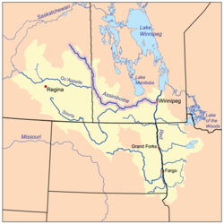
325:. North-west of the city, the river empties into Melville Reservoir. From there, Crescent Creek carries on eastward skirting the northern edge of Melville, running through the middle of
58:
770:
352:
609:
380:), also known as Crescent Creek Reservoir, is a man-made lake along the course of Crescent Creek north-west of Melville. The dam was built in 1921 by the
635:
765:
221:
86:
760:
755:
287:
137:
775:
745:
750:
397:
303:
402:
295:
169:
407:
381:
687:
505:
479:
341:
and
Crescent Lake. Crescent Lake is a shallow lake that connects to Leech Lake, the source of Yorkton Creek.
334:
330:
713:
326:
322:
318:
314:
181:
338:
207:
583:
453:
427:
307:
275:
298:
and flows in an easterly direction into
Crescent Lake. Crescent Creek is a tributary of
269:
739:
299:
291:
150:
41:
17:
661:
531:
192:
367:
354:
236:
223:
130:
46:
Red River drainage basin, with the
Assiniboine River highlighted
557:
93:
65:
337:. After Melville, the river continues east into the
267:
262:
252:
213:
201:
191:
175:
165:
156:
136:
118:
113:
34:
8:
317:, Crescent Creek flows south-east into the
286:is a river in the south-east region of the
419:
101:Crescent Creek (Saskatchewan) (Canada)
31:
636:"Melville Town Reservoir Fishing Map"
73:Location of the mouth in Saskatchewan
7:
771:Tributaries of the Assiniboine River
588:Canadian Geographical Names Database
458:Canadian Geographical Names Database
432:Canadian Geographical Names Database
506:"Crescent Creek, Saskatchewan Map:"
25:
480:"Crescent Lake, Saskatchewan Map"
564:. Melville Golf and Country Club
558:"Melville Golf and Country Club"
143:
123:
92:
85:
64:
57:
40:
562:Melville Golf and Country Club
398:List of rivers of Saskatchewan
327:Melville Golf and Country Club
215: • coordinates
1:
766:Stanley No. 215, Saskatchewan
403:List of lakes of Saskatchewan
302:, which flows north into the
157:Physical characteristics
27:River in Saskatchewan, Canada
254: • elevation
761:Garry No. 245, Saskatchewan
321:and on towards the city of
203: • location
177: • location
792:
756:Cana No. 214, Saskatchewan
688:"Melville Reservoir Trail"
294:. The river begins in the
258:512 m (1,680 ft)
776:Tributaries of Hudson Bay
408:Hudson Bay drainage basin
382:Canadian National Railway
187:
161:
51:
39:
76:Show map of Saskatchewan
662:"Water Treatment Plant"
746:Rivers of Saskatchewan
590:. Government of Canada
460:. Government of Canada
434:. Government of Canada
751:Lakes of Saskatchewan
714:"Crescent Creek Loop"
319:RM of Stanley No. 215
368:50.9516°N 102.8496°W
349:Melville Reservoir (
306:–a tributary of the
237:51.0167°N 102.4671°W
640:GPS Nautical Charts
616:. ResearchGate GmbH
364: /
315:RM of Garry No. 245
263:Basin features
233: /
182:RM of Garry No. 245
668:. City of Melville
373:50.9516; -102.8496
345:Melville Reservoir
339:RM of Cana No. 214
242:51.0167; -102.4671
208:RM of Cana No. 214
104:Show map of Canada
18:Melville Reservoir
313:Beginning in the
308:Assiniboine River
288:Canadian province
281:
280:
276:Assiniboine River
16:(Redirected from
783:
730:
729:
727:
725:
720:. AllTrails, LLC
710:
704:
703:
701:
699:
694:. AllTrails, LLC
684:
678:
677:
675:
673:
666:City of Melville
658:
652:
651:
649:
647:
632:
626:
625:
623:
621:
606:
600:
599:
597:
595:
580:
574:
573:
571:
569:
554:
548:
547:
545:
543:
532:"Crescent Creek"
528:
522:
521:
519:
517:
502:
496:
495:
493:
491:
476:
470:
469:
467:
465:
450:
444:
443:
441:
439:
428:"Crescent Creek"
424:
379:
378:
376:
375:
374:
369:
365:
362:
361:
360:
357:
272:
248:
247:
245:
244:
243:
238:
234:
231:
230:
229:
226:
178:
149:
147:
146:
129:
127:
126:
105:
96:
95:
89:
77:
68:
67:
61:
44:
32:
21:
791:
790:
786:
785:
784:
782:
781:
780:
736:
735:
734:
733:
723:
721:
712:
711:
707:
697:
695:
686:
685:
681:
671:
669:
660:
659:
655:
645:
643:
634:
633:
629:
619:
617:
610:"Yorkton Creek"
608:
607:
603:
593:
591:
584:"Crescent Lake"
582:
581:
577:
567:
565:
556:
555:
551:
541:
539:
530:
529:
525:
515:
513:
504:
503:
499:
489:
487:
478:
477:
473:
463:
461:
452:
451:
447:
437:
435:
426:
425:
421:
416:
394:
372:
370:
366:
363:
358:
355:
353:
351:
350:
347:
329:, and crossing
304:Whitesand River
268:
255:
241:
239:
235:
232:
227:
224:
222:
220:
219:
216:
204:
176:
144:
142:
124:
122:
109:
108:
107:
106:
103:
102:
99:
98:
97:
80:
79:
78:
75:
74:
71:
70:
69:
47:
28:
23:
22:
15:
12:
11:
5:
789:
787:
779:
778:
773:
768:
763:
758:
753:
748:
738:
737:
732:
731:
705:
679:
653:
627:
601:
575:
549:
538:. Geoview.info
523:
497:
471:
454:"Beaver Hills"
445:
418:
417:
415:
412:
411:
410:
405:
400:
393:
390:
346:
343:
284:Crescent Creek
279:
278:
273:
265:
264:
260:
259:
256:
253:
250:
249:
217:
214:
211:
210:
205:
202:
199:
198:
195:
189:
188:
185:
184:
179:
173:
172:
167:
163:
162:
159:
158:
154:
153:
140:
134:
133:
120:
116:
115:
111:
110:
100:
91:
90:
84:
83:
82:
81:
72:
63:
62:
56:
55:
54:
53:
52:
49:
48:
45:
37:
36:
35:Crescent Creek
26:
24:
14:
13:
10:
9:
6:
4:
3:
2:
788:
777:
774:
772:
769:
767:
764:
762:
759:
757:
754:
752:
749:
747:
744:
743:
741:
719:
715:
709:
706:
693:
689:
683:
680:
667:
663:
657:
654:
641:
637:
631:
628:
615:
614:Research Gate
611:
605:
602:
589:
585:
579:
576:
563:
559:
553:
550:
537:
533:
527:
524:
511:
507:
501:
498:
485:
481:
475:
472:
459:
455:
449:
446:
433:
429:
423:
420:
413:
409:
406:
404:
401:
399:
396:
395:
391:
389:
385:
383:
377:
344:
342:
340:
336:
332:
328:
324:
320:
316:
311:
309:
305:
301:
300:Yorkton Creek
297:
293:
289:
285:
277:
274:
271:
266:
261:
257:
251:
246:
218:
212:
209:
206:
200:
197:Crescent Lake
196:
194:
190:
186:
183:
180:
174:
171:
168:
164:
160:
155:
152:
141:
139:
135:
132:
121:
117:
112:
88:
60:
50:
43:
38:
33:
30:
19:
722:. Retrieved
717:
708:
696:. Retrieved
691:
682:
670:. Retrieved
665:
656:
644:. Retrieved
639:
630:
618:. Retrieved
613:
604:
592:. Retrieved
587:
578:
566:. Retrieved
561:
552:
540:. Retrieved
536:Geoview.info
535:
526:
514:. Retrieved
512:. Geodata.us
509:
500:
488:. Retrieved
486:. Geodata.us
483:
474:
462:. Retrieved
457:
448:
436:. Retrieved
431:
422:
386:
348:
312:
296:Beaver Hills
292:Saskatchewan
283:
282:
270:River system
170:Beaver Hills
151:Saskatchewan
29:
371: /
359:102°50′59″W
331:Highways 47
240: /
228:102°28′02″W
740:Categories
642:. Bist LLC
510:Geodata.us
484:Geodata.us
414:References
356:50°57′06″N
225:51°01′00″N
718:AllTrails
692:AllTrails
138:Provinces
392:See also
323:Melville
114:Location
119:Country
724:28 May
698:28 May
672:28 May
646:28 May
620:28 May
594:28 May
568:30 May
542:28 May
516:28 May
490:28 May
464:28 May
438:28 May
166:Source
148:
131:Canada
128:
193:Mouth
726:2022
700:2022
674:2022
648:2022
622:2022
596:2022
570:2022
544:2022
518:2022
492:2022
466:2022
440:2022
333:and
290:of
742::
716:.
690:.
664:.
638:.
612:.
586:.
560:.
534:.
508:.
482:.
456:.
430:.
335:10
310:.
728:.
702:.
676:.
650:.
624:.
598:.
572:.
546:.
520:.
494:.
468:.
442:.
20:)
Text is available under the Creative Commons Attribution-ShareAlike License. Additional terms may apply.