182:) although the official Menunkatuck Trail blue-blazes end just after the Menunkatuck Trail splits southward from the "White Trail" in the Nut Plains Woods (Guilford Land Conservation Trust). South of Nut Plains Road the trail to the Guilford dump is marked with red-orange plastic ribbons tied to trees. Eventually the plan is for the Menunkatuck Trail to be extended to Long Island Sound (possibly via some road walks) but the trail currently is approximately 3.0-mile (4.8 km) directly due north of Guilford Harbor (and approximately 2.0-mile (3.2 km) due north of US I-95.).
195:
26:
281:
987:
185:
The trail walk can be extended southward from just outside the waste site on
Sullivan Drive by following a red-orange plastic ribbon marked trail through the Guilford town-owned East River Preserve to a trailhead on Clapboard Hill Road north of the intersection with Meadowlands. By walking from the
186:
East River
Preserve trail head on Clapboard Hill Road and then down Meadowlands a ways the trail head to a nature trail on Audubon Society property (the Guilford Salt Meadows Sanctuary) can be found and can extend the walk a bit farther.
350:
A large portion of the
Menunkatuck Trail passes through or near protected wetlands: bogs, swamps, vernal ponds and marsh lands. Wooden walkways are planned to allow easy passage over some of these which flood or become muddy often.
330:
is a hazard on exposed summits and ledges during thunderstorms. Snow is common in the winter and may necessitate the use of snowshoes. Ice can form on exposed ledges and summits, making hiking dangerous without special equipment.
608:
361:
Much of the trail is protected, owned and managed by either the Town of
Guilford (often by the Conservation Committee), the Guilford Conservation Land Trust or the state (as a part of the Cockaponset State Forest).
365:
Land owned by the
Regional Water Authority and private owners is not necessarily nor specifically protected but temporary easements have been negotiated to allow the trail to pass through these properties.
576:
2676:
137:
and, currently, is almost entirely on protected land owned by the Town of
Guilford, the Guilford Conservation Land Trust, the Regional Water Authority (RWA) and on Cockaponset State Forest land.
1018:
316:
The mainline trail is blazed with blue rectangles. Trail descriptions are available from a number of commercial and non-commercial sources, and a complete guidebook is published by the
639:
151:
The current southern trail head terminates at a parking lot just outside the Town of
Guilford's bulky waste site (and "Stump Dump" on Sullivan Drive just off Goose Lane (
2362:
1065:
2327:
1098:
951:
1882:
562:
1070:
1011:
1950:
144:
near its southernmost point (approximately 1.3-mile (2.1 km) east of the
Mattabesett Trail's intersection with (and "Bluff Head" parking lot on)
1589:
354:
There are sections of the trail which are narrow forested easements between streets of substantial houses. These protected green spaces are often '
2125:
1004:
632:
317:
270:
2120:
1604:
1156:
1108:
2698:
2569:
1669:
1234:
140:
The mainline (official "Blue" "non-dot") trail is primarily a north / south linear trail with a northern trail head which terminates at the
1694:
1027:
2433:
2382:
2292:
1935:
1194:
673:
2392:
1047:
625:
2080:
2005:
1732:
1714:
1294:
1279:
1239:
1093:
846:
544:
523:
502:
481:
471:
392:
154:
613:. Vol. II (1818 printing ed.). New Haven, Connecticut: Maltby, Goldsmith & Co. and Samuel Wadsworth. pp. 1–1166.
2135:
2090:
599:. Vol. I (1818 printing ed.). New Haven, Connecticut: Maltby, Goldsmith & Co. and Samuel Wadsworth. pp. 1–1166.
261:
The official Blue-Blazed
Menunkatuck Trail passes through land located within the following municipalities, from south to north:
1319:
926:
2140:
2000:
1995:
1965:
1955:
1434:
1359:
1249:
1166:
2165:
2075:
2025:
1975:
1940:
2297:
1980:
1960:
1915:
1494:
1189:
811:
460:
439:
2145:
2095:
2045:
2040:
1930:
2160:
2035:
2030:
1990:
1900:
1890:
342:) are a potential hazard. Wearing bright orange clothing during the hunting season (Fall through December) is recommended.
2332:
2085:
2065:
2060:
1945:
1910:
1905:
1747:
1389:
1364:
1274:
1254:
1224:
198:
This bridge over a stream in the
Guilford section of the Cockaponset State Forest is this young man's Eagle Scout project.
95:
2612:
2175:
2115:
2020:
2015:
1970:
2657:
2110:
2070:
2055:
1920:
1727:
1619:
1489:
1464:
1354:
1349:
1199:
941:
761:
683:
2150:
2130:
2105:
2100:
1895:
2607:
2302:
2170:
2050:
1925:
1704:
1659:
1559:
1459:
1244:
871:
2155:
2010:
1985:
2597:
2402:
194:
2652:
2201:
1699:
1689:
1679:
1674:
1634:
1624:
1609:
1584:
1564:
1544:
1449:
1409:
1369:
1329:
741:
678:
2407:
1852:
1644:
1554:
1504:
1424:
1394:
1379:
1339:
1204:
1179:
1146:
966:
791:
806:
668:
572:
2587:
2372:
2261:
1792:
1737:
1684:
1639:
1594:
1479:
1429:
1334:
1284:
1057:
936:
207:
25:
2548:
2397:
2337:
2256:
1872:
1832:
1817:
1782:
1767:
1752:
1664:
1629:
1614:
1474:
1439:
1324:
1309:
1219:
1184:
961:
2347:
2632:
2458:
2412:
2251:
1857:
1842:
1797:
1762:
1722:
1599:
1524:
1519:
1454:
1444:
1404:
1384:
1269:
1259:
1214:
1080:
746:
726:
2617:
2438:
2236:
2216:
2196:
1862:
1847:
1802:
1787:
1757:
1649:
1574:
1569:
1534:
1509:
1469:
1419:
1414:
1344:
1289:
1209:
1039:
901:
776:
688:
130:
31:
856:
721:
578:
New England Gazetteer: Containing Descriptions of the States, Counties, Cities and Towns of New England
2647:
2642:
2622:
2211:
2387:
1837:
1827:
1822:
1812:
1777:
1579:
1514:
1229:
1174:
931:
881:
771:
698:
693:
222:
145:
75:
2453:
2357:
2312:
2282:
2246:
1867:
1807:
1772:
1742:
1549:
1484:
1374:
1314:
1264:
971:
736:
716:
2662:
2528:
2483:
2443:
2367:
2287:
2241:
2191:
1654:
1539:
1529:
1499:
911:
821:
663:
122:
816:
751:
455:(19 ed.). Rockfall, Connecticut: Connecticut Forest and Park Association. pp. 1–353.
434:(19 ed.). Rockfall, Connecticut: Connecticut Forest and Park Association. pp. 1–261.
2468:
2417:
2221:
1088:
836:
781:
711:
604:
590:
540:
519:
498:
477:
456:
435:
388:
335:
141:
104:
30:
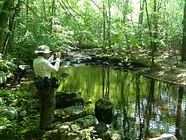
Vernal pond along the Menunkatuck Trail near the Iron Stream in the Timberlands town forest.
326:. Conditions on exposed ridge tops and summits may be harsher during cold or stormy weather.
2543:
2518:
2508:
2463:
1136:
1131:
1126:
956:
896:
866:
766:
242:
2627:
2533:
2523:
2493:
2478:
2448:
2322:
2231:
2206:
1399:
1141:
1121:
921:
916:
906:
891:
886:
831:
801:
786:
731:
706:
87:
2377:
2637:
2602:
2592:
2498:
2488:
2352:
2226:
841:
826:
518:(1 ed.). Guilford, Connecticut: Appalachian Mountain Club Books. pp. 1–320.
280:
2692:
2503:
2317:
1304:
1299:
1151:
1116:
861:
851:
756:
250:
230:
2538:
2513:
946:
876:
339:
996:
594:
450:
429:
2307:
1031:
652:
534:
513:
492:
323:
134:
79:
35:
617:
2553:
2342:
976:
582:
246:
226:
211:
108:
169:
156:
2266:
564:
History of the Indians of Connecticut from the earliest known period to 1850
476:(1 ed.). Mechanicsburg, Pennsylvania: Stackpole Books. pp. 1–304.
327:
215:
539:(2 ed.). Guilford, Connecticut: Falcon Publishing. pp. 1–336.
497:(7 ed.). Guilford, Connecticut: Falcon Publishing. pp. 1–192.
238:
234:
83:
203:
126:
100:
71:
986:
648:
473:
Hikes in southern New England: Connecticut, Massachusetts, Vermont
193:
334:
Biting insects can be bothersome during warm weather. Parasitic
1000:
621:
275:
2677:
Connecticut Department of Energy and Environmental Protection
610:
A Complete History of Connecticut - Civil and Ecclesiastical
596:
A Complete History of Connecticut - Civil and Ecclesiastical
567:. Hartford, Connecticut: Wm. Jas. Hamersley. pp. 1–509.
407:
229:. Site-specific activities enjoyed along the route include
387:(19th ed.). Connecticut Forest and Park Association.
221:
Portions of the trail are suitable for, and are used for,
292:
269:
The Blue-Blazed Menunkatuck Trail was created by the
491:
Keyarts, Eugene (2002). Pietrzyk, Cindi Dale (ed.).
2578:
2562:
2426:
2275:
2184:
1881:
1713:
1165:
1107:
1079:
1056:
1038:
94:
67:
59:
51:
43:
18:
346:Conservation and maintenance of the trail corridor
358:created during residential housing development.
2328:Connecticut Audubon Society Center at Fairfield
2363:Joshua's Tract Conservation and Historic Trust
1012:
633:
8:
512:Laubach, Rene; Smith, Charles W. G. (2007).
202:The Menunkatuck Trail is primarily used for
533:Ostertag, Rhonda; Ostertag, George (2002).
1019:
1005:
997:
640:
626:
618:
494:Short Nature Walks: Connecticut Guide Book
1099:Washington–Rochambeau Revolutionary Route
952:Washington–Rochambeau Revolutionary Route
555:Books – Connecticut history and geography
375:
318:Connecticut Forest and Park Association
271:Connecticut Forest and Park Association
322:Weather along the route is typical of
15:
2570:List of nature centers in Connecticut
2121:Salmon River Cove and Haddam Neck WMA
1590:Satan's Kingdom State Recreation Area
581:(2 ed.). Boston, Massachusetts:
7:
1695:Windsor Locks Canal State Park Trail
2613:Happy Landings Protected Open Space
2434:American Legion State Forest Trails
2393:Stamford Museum & Nature Center
2293:Audubon Center at Bent of the River
2021:Little River Fish and Wildlife Area
1195:Beckley Furnace Industrial Monument
515:AMC's Best Day Hikes in Connecticut
1048:Weir Farm National Historical Park
14:
2101:Roger Tory Peterson Wildlife Area
1094:New England National Scenic Trail
2608:Gurski Farm Protected Open Space
985:
279:
24:
120:is an 11.0-mile (17.7 km)
2598:Burr Farm Protected Open Space
2403:Weantinoge Heritage Land Trust
2298:Bartlett Arboretum and Gardens
1495:Moosup Valley State Park Trail
1190:Becket Hill State Park Reserve
1:
2333:Connecticut College Arboretum
2699:Hiking trails in Connecticut
2658:Webb Mountain Discovery Zone
1255:Connecticut Valley Railroad
536:Hiking Southern New England
90:(parts of the trail), other
2715:
2081:Quinnipiac River Marsh WMA
1585:Salt Rock State Campground
1370:Hop River State Park Trail
452:Connecticut Walk Book West
431:Connecticut Walk Book East
422:Books – Connecticut hiking
385:Connecticut Walk Book West
338:(which are known to carry
47:11.0 miles (17.7 km)
2671:
2588:Bear Mountain Reservation
2408:White Memorial Foundation
2262:West Pequonnock Reservoir
1883:Wildlife Management Areas
1300:Fort Griswold Battlefield
1058:National Wildlife Refuges
983:
727:Farmington Canal Heritage
659:
23:
2373:New Canaan Nature Center
561:De Forest, John (1853).
470:Emblidge, David (1998).
2549:Whitestone Cliffs Trail
2257:West Hartford Reservoir
2136:Skiff Mountain Coop WMA
2091:Raymond Brook Marsh WMA
1440:Larkin State Park Trail
449:Colson, Ann T. (2006).
428:Colson, Ann T. (2005).
383:Colson, Ann T. (2006).
2459:Housatonic Range Trail
2413:Woodcock Nature Center
2398:Steep Rock Association
2006:King's Island Coop WMA
1951:Charles E. Wheeler WMA
1260:Dart Island State Park
1109:Wild and Scenic Rivers
199:
63:CFPA Blue-Blazed Trail
2618:Lighthouse Point Park
2439:Aspetuck Valley Trail
2383:Pine Mountain Reserve
2348:Great Mountain Forest
2237:Mansfield Hollow Lake
2197:Barkhamsted Reservoir
2141:James V. Spignesi WMA
1320:George Dudley Seymour
1040:National Park Service
942:Sunny Valley Preserve
214:, and in the winter,
197:
2633:Old Bridge Sanctuary
2388:Saltonstall Mountain
2338:Devil's Den Preserve
2252:Trap Falls Reservoir
2001:Housatonic River WMA
1996:Higganum Meadows WMA
1966:East River Marsh WMA
1956:Cromwell Meadows WMA
1733:Centennial Watershed
1435:Lamentation Mountain
1250:Collis P. Huntington
932:Still River Greenway
703:Charter Oak Greenway
265:History and folklore
223:cross-country skiing
146:Connecticut Route 77
76:cross-country skiing
2454:Hancock Brook Trail
2358:Highstead Arboretum
2313:Branford Land Trust
2283:Aspetuck Land Trust
2247:Saugatuck Reservoir
2166:Wangunk Meadows WMA
2076:Quinebaug River WMA
1976:Eightmile River WMA
1941:Candlewood Hill WMA
1605:Seth Low Pierrepont
1071:Stewart B. McKinney
717:East Coast Greenway
669:Alain and May White
170:41.3125°N 72.6745°W
166: /
2663:Webb Mountain Park
2529:Salmon River Trail
2484:Narragansett Trail
2444:Blue-Blazed Trails
2368:McLean Game Refuge
2217:Far Mill Reservoir
2192:Aspetuck Reservoir
2126:Sessions Woods WMA
1981:Franklin Swamp WMA
1961:Durham Meadows WMA
1916:Bartlett Brook WMA
1670:Trout Brook Valley
1390:Housatonic Meadows
1365:Higganum Reservoir
1225:Brainard Homestead
937:Stony Creek Quarry
792:McLean Game Refuge
605:Trumbull, Benjamin
591:Trumbull, Benjamin
291:. You can help by
200:
2686:
2685:
2474:Menunkatuck Trail
2469:Mattabesett Trail
2418:Yale-Myers Forest
2222:Hemlock Reservoir
2146:Stanley Works WMA
2096:Robbins Swamp WMA
2046:Messerschmidt WMA
2041:Menunketesuck WMA
1931:Bishops Swamp WMA
1465:Mashamoquet Brook
1360:Haystack Mountain
1355:Harkness Memorial
1350:Hammonasset Beach
1089:Appalachian Trail
994:
993:
962:Whitestone Cliffs
585:. pp. 1–704.
309:
308:
257:Trail communities
190:Trail description
175:41.3125; -72.6745
142:Mattabesett Trail
118:Menunkatuck Trail
114:
113:
19:Menunkatuck Trail
2706:
2648:Salt Meadow Park
2643:Roosevelt Forest
2623:Lillinonah Woods
2579:Local Government
2544:Westwoods Trails
2519:Quinnipiac Trail
2509:Paugussett Trail
2464:Lillinonah Trail
2212:Easton Reservoir
2161:Tankerhoosen WMA
2036:Meadow Brook WMA
2031:Maromas Coop WMA
1991:Great Harbor WMA
1901:Babcock Pond WMA
1891:Aldo Leopold WMA
1748:James L. Goodwin
1705:Wooster Mountain
1660:Talcott Mountain
1560:Quinnipiac River
1460:Mansfield Hollow
1295:Farmington Canal
1245:Chatfield Hollow
1137:Housatonic River
1132:Green Fall River
1127:Farmington River
1021:
1014:
1007:
998:
989:
747:Housatonic Range
684:Arthur A. Harris
642:
635:
628:
619:
614:
600:
586:
568:
550:
529:
508:
487:
466:
445:
410:
405:
399:
398:
380:
312:Hiking the trail
304:
301:
283:
276:
243:horseback riding
237:(very limited),
181:
180:
178:
177:
176:
171:
167:
164:
163:
162:
159:
28:
16:
2714:
2713:
2709:
2708:
2707:
2705:
2704:
2703:
2689:
2688:
2687:
2682:
2667:
2628:Mill River Park
2580:
2574:
2558:
2534:Shenipsit Trail
2524:Regicides Trail
2494:Naugatuck Trail
2479:Metacomet Trail
2449:Chatfield Trail
2422:
2323:Cathedral Pines
2271:
2232:Lake Lillinonah
2207:Candlewood Lake
2202:Beaver Dam Lake
2180:
2086:Ragged Rock WMA
2066:Pease Brook WMA
2061:Nott Island WMA
2026:Lord's Cove WMA
1946:Cedar Swamp WMA
1911:Barn Island WMA
1906:Barber Pond WMA
1877:
1728:American Legion
1709:
1700:Windsor Meadows
1690:Whittemore Glen
1680:West Rock Ridge
1675:Wadsworth Falls
1635:Stillwater Pond
1625:Southford Falls
1610:Sherwood Island
1565:River Highlands
1545:Putnam Memorial
1485:Mohawk Mountain
1450:Macedonia Brook
1410:John A. Minetto
1330:Gillette Castle
1275:Devil's Hopyard
1161:
1142:Pawcatuck River
1122:Eightmile River
1103:
1081:National Trails
1075:
1066:Silvio O. Conte
1052:
1034:
1028:Protected areas
1025:
995:
990:
981:
902:Ragged Mountain
777:Macedonia Brook
689:Aspetuck Valley
674:American Legion
655:
646:
603:
589:
571:
560:
547:
532:
526:
511:
505:
490:
484:
469:
463:
448:
442:
427:
419:
417:Further reading
414:
413:
406:
402:
395:
382:
381:
377:
372:
348:
314:
305:
299:
296:
289:needs expansion
267:
259:
192:
174:
172:
168:
165:
160:
157:
155:
153:
152:
88:mountain biking
39:
12:
11:
5:
2712:
2710:
2702:
2701:
2691:
2690:
2684:
2683:
2681:
2680:
2672:
2669:
2668:
2666:
2665:
2660:
2655:
2650:
2645:
2640:
2638:Pleasure Beach
2635:
2630:
2625:
2620:
2615:
2610:
2605:
2603:East Rock Park
2600:
2595:
2593:Beardsley Park
2590:
2584:
2582:
2576:
2575:
2573:
2572:
2566:
2564:
2563:Nature centers
2560:
2559:
2557:
2556:
2551:
2546:
2541:
2536:
2531:
2526:
2521:
2516:
2511:
2506:
2501:
2499:Nehantic Trail
2496:
2491:
2489:Natchaug Trail
2486:
2481:
2476:
2471:
2466:
2461:
2456:
2451:
2446:
2441:
2436:
2430:
2428:
2424:
2423:
2421:
2420:
2415:
2410:
2405:
2400:
2395:
2390:
2385:
2380:
2375:
2370:
2365:
2360:
2355:
2353:Higby Mountain
2350:
2345:
2340:
2335:
2330:
2325:
2320:
2315:
2310:
2305:
2300:
2295:
2290:
2285:
2279:
2277:
2273:
2272:
2270:
2269:
2264:
2259:
2254:
2249:
2244:
2239:
2234:
2229:
2227:Hop Brook Lake
2224:
2219:
2214:
2209:
2204:
2199:
2194:
2188:
2186:
2182:
2181:
2179:
2178:
2176:Zemko Pond WMA
2173:
2168:
2163:
2158:
2153:
2148:
2143:
2138:
2133:
2128:
2123:
2118:
2116:Ross Marsh WMA
2113:
2108:
2103:
2098:
2093:
2088:
2083:
2078:
2073:
2068:
2063:
2058:
2053:
2048:
2043:
2038:
2033:
2028:
2023:
2018:
2016:Larson Lot WMA
2013:
2008:
2003:
1998:
1993:
1988:
1983:
1978:
1973:
1971:East Swamp WMA
1968:
1963:
1958:
1953:
1948:
1943:
1938:
1936:Black Pond WMA
1933:
1928:
1923:
1918:
1913:
1908:
1903:
1898:
1893:
1887:
1885:
1879:
1878:
1876:
1875:
1870:
1865:
1860:
1855:
1850:
1845:
1840:
1835:
1830:
1825:
1820:
1815:
1810:
1805:
1800:
1795:
1790:
1785:
1780:
1775:
1770:
1765:
1760:
1755:
1750:
1745:
1740:
1735:
1730:
1725:
1719:
1717:
1711:
1710:
1708:
1707:
1702:
1697:
1692:
1687:
1682:
1677:
1672:
1667:
1662:
1657:
1652:
1647:
1645:Stratton Brook
1642:
1637:
1632:
1627:
1622:
1620:Sleeping Giant
1617:
1612:
1607:
1602:
1597:
1592:
1587:
1582:
1577:
1572:
1567:
1562:
1557:
1555:Quinebaug Lake
1552:
1547:
1542:
1537:
1532:
1527:
1522:
1517:
1512:
1507:
1505:Mount Bushnell
1502:
1497:
1492:
1487:
1482:
1477:
1472:
1467:
1462:
1457:
1452:
1447:
1442:
1437:
1432:
1427:
1425:Killingly Pond
1422:
1417:
1412:
1407:
1402:
1397:
1395:Humaston Brook
1392:
1387:
1382:
1380:Hopeville Pond
1377:
1372:
1367:
1362:
1357:
1352:
1347:
1342:
1340:Haddam Meadows
1337:
1332:
1327:
1322:
1317:
1312:
1307:
1302:
1297:
1292:
1287:
1282:
1277:
1272:
1267:
1262:
1257:
1252:
1247:
1242:
1240:Campbell Falls
1237:
1232:
1227:
1222:
1217:
1212:
1207:
1205:Bigelow Hollow
1202:
1200:Bennett's Pond
1197:
1192:
1187:
1182:
1177:
1171:
1169:
1163:
1162:
1160:
1159:
1154:
1149:
1144:
1139:
1134:
1129:
1124:
1119:
1113:
1111:
1105:
1104:
1102:
1101:
1096:
1091:
1085:
1083:
1077:
1076:
1074:
1073:
1068:
1062:
1060:
1054:
1053:
1051:
1050:
1044:
1042:
1036:
1035:
1026:
1024:
1023:
1016:
1009:
1001:
992:
991:
984:
982:
980:
979:
974:
969:
964:
959:
954:
949:
944:
939:
934:
929:
927:Sleeping Giant
924:
919:
914:
909:
904:
899:
894:
889:
884:
879:
874:
869:
864:
859:
854:
849:
844:
839:
834:
829:
824:
819:
814:
809:
804:
799:
794:
789:
784:
779:
774:
769:
764:
759:
754:
749:
744:
739:
734:
729:
724:
719:
714:
709:
704:
701:
696:
694:Bigelow Hollow
691:
686:
681:
676:
671:
666:
660:
657:
656:
647:
645:
644:
637:
630:
622:
616:
615:
601:
587:
569:
552:
551:
545:
530:
524:
509:
503:
488:
482:
467:
461:
446:
440:
418:
415:
412:
411:
400:
393:
374:
373:
371:
368:
347:
344:
313:
310:
307:
306:
286:
284:
266:
263:
258:
255:
191:
188:
112:
111:
98:
92:
91:
69:
65:
64:
61:
57:
56:
53:
49:
48:
45:
41:
40:
29:
21:
20:
13:
10:
9:
6:
4:
3:
2:
2711:
2700:
2697:
2696:
2694:
2679:
2678:
2674:
2673:
2670:
2664:
2661:
2659:
2656:
2654:
2651:
2649:
2646:
2644:
2641:
2639:
2636:
2634:
2631:
2629:
2626:
2624:
2621:
2619:
2616:
2614:
2611:
2609:
2606:
2604:
2601:
2599:
2596:
2594:
2591:
2589:
2586:
2585:
2583:
2577:
2571:
2568:
2567:
2565:
2561:
2555:
2552:
2550:
2547:
2545:
2542:
2540:
2537:
2535:
2532:
2530:
2527:
2525:
2522:
2520:
2517:
2515:
2512:
2510:
2507:
2505:
2504:Nipmuck Trail
2502:
2500:
2497:
2495:
2492:
2490:
2487:
2485:
2482:
2480:
2477:
2475:
2472:
2470:
2467:
2465:
2462:
2460:
2457:
2455:
2452:
2450:
2447:
2445:
2442:
2440:
2437:
2435:
2432:
2431:
2429:
2425:
2419:
2416:
2414:
2411:
2409:
2406:
2404:
2401:
2399:
2396:
2394:
2391:
2389:
2386:
2384:
2381:
2379:
2376:
2374:
2371:
2369:
2366:
2364:
2361:
2359:
2356:
2354:
2351:
2349:
2346:
2344:
2341:
2339:
2336:
2334:
2331:
2329:
2326:
2324:
2321:
2319:
2318:Case Mountain
2316:
2314:
2311:
2309:
2306:
2304:
2303:Bear Mountain
2301:
2299:
2296:
2294:
2291:
2289:
2286:
2284:
2281:
2280:
2278:
2274:
2268:
2265:
2263:
2260:
2258:
2255:
2253:
2250:
2248:
2245:
2243:
2240:
2238:
2235:
2233:
2230:
2228:
2225:
2223:
2220:
2218:
2215:
2213:
2210:
2208:
2205:
2203:
2200:
2198:
2195:
2193:
2190:
2189:
2187:
2183:
2177:
2174:
2172:
2169:
2167:
2164:
2162:
2159:
2157:
2154:
2152:
2149:
2147:
2144:
2142:
2139:
2137:
2134:
2132:
2129:
2127:
2124:
2122:
2119:
2117:
2114:
2112:
2111:Rose Hill WMA
2109:
2107:
2104:
2102:
2099:
2097:
2094:
2092:
2089:
2087:
2084:
2082:
2079:
2077:
2074:
2072:
2071:Plum Bank WMA
2069:
2067:
2064:
2062:
2059:
2057:
2056:Nod Brook WMA
2054:
2052:
2049:
2047:
2044:
2042:
2039:
2037:
2034:
2032:
2029:
2027:
2024:
2022:
2019:
2017:
2014:
2012:
2009:
2007:
2004:
2002:
1999:
1997:
1994:
1992:
1989:
1987:
1984:
1982:
1979:
1977:
1974:
1972:
1969:
1967:
1964:
1962:
1959:
1957:
1954:
1952:
1949:
1947:
1944:
1942:
1939:
1937:
1934:
1932:
1929:
1927:
1924:
1922:
1921:Bear Hill WMA
1919:
1917:
1914:
1912:
1909:
1907:
1904:
1902:
1899:
1897:
1894:
1892:
1889:
1888:
1886:
1884:
1880:
1874:
1871:
1869:
1866:
1864:
1861:
1859:
1856:
1854:
1851:
1849:
1846:
1844:
1841:
1839:
1836:
1834:
1831:
1829:
1826:
1824:
1821:
1819:
1816:
1814:
1811:
1809:
1806:
1804:
1801:
1799:
1796:
1794:
1791:
1789:
1786:
1784:
1781:
1779:
1776:
1774:
1771:
1769:
1766:
1764:
1761:
1759:
1756:
1754:
1751:
1749:
1746:
1744:
1741:
1739:
1736:
1734:
1731:
1729:
1726:
1724:
1721:
1720:
1718:
1716:
1715:State Forests
1712:
1706:
1703:
1701:
1698:
1696:
1693:
1691:
1688:
1686:
1685:Wharton Brook
1683:
1681:
1678:
1676:
1673:
1671:
1668:
1666:
1663:
1661:
1658:
1656:
1653:
1651:
1648:
1646:
1643:
1641:
1640:Stoddard Hill
1638:
1636:
1633:
1631:
1628:
1626:
1623:
1621:
1618:
1616:
1613:
1611:
1608:
1606:
1603:
1601:
1598:
1596:
1595:Scantic River
1593:
1591:
1588:
1586:
1583:
1581:
1578:
1576:
1573:
1571:
1568:
1566:
1563:
1561:
1558:
1556:
1553:
1551:
1548:
1546:
1543:
1541:
1538:
1536:
1533:
1531:
1528:
1526:
1523:
1521:
1518:
1516:
1513:
1511:
1508:
1506:
1503:
1501:
1498:
1496:
1493:
1491:
1488:
1486:
1483:
1481:
1480:Minnie Island
1478:
1476:
1473:
1471:
1468:
1466:
1463:
1461:
1458:
1456:
1453:
1451:
1448:
1446:
1443:
1441:
1438:
1436:
1433:
1431:
1430:Lake Waramaug
1428:
1426:
1423:
1421:
1418:
1416:
1413:
1411:
1408:
1406:
1403:
1401:
1398:
1396:
1393:
1391:
1388:
1386:
1383:
1381:
1378:
1376:
1373:
1371:
1368:
1366:
1363:
1361:
1358:
1356:
1353:
1351:
1348:
1346:
1343:
1341:
1338:
1336:
1335:Haddam Island
1333:
1331:
1328:
1326:
1323:
1321:
1318:
1316:
1313:
1311:
1308:
1306:
1305:Fort Trumbull
1303:
1301:
1298:
1296:
1293:
1291:
1288:
1286:
1285:Eagle Landing
1283:
1281:
1278:
1276:
1273:
1271:
1268:
1266:
1263:
1261:
1258:
1256:
1253:
1251:
1248:
1246:
1243:
1241:
1238:
1236:
1235:Camp Columbia
1233:
1231:
1228:
1226:
1223:
1221:
1218:
1216:
1213:
1211:
1208:
1206:
1203:
1201:
1198:
1196:
1193:
1191:
1188:
1186:
1183:
1181:
1178:
1176:
1173:
1172:
1170:
1168:
1164:
1158:
1155:
1153:
1152:Shunock River
1150:
1148:
1145:
1143:
1140:
1138:
1135:
1133:
1130:
1128:
1125:
1123:
1120:
1118:
1117:Ashaway River
1115:
1114:
1112:
1110:
1106:
1100:
1097:
1095:
1092:
1090:
1087:
1086:
1084:
1082:
1078:
1072:
1069:
1067:
1064:
1063:
1061:
1059:
1055:
1049:
1046:
1045:
1043:
1041:
1037:
1033:
1029:
1022:
1017:
1015:
1010:
1008:
1003:
1002:
999:
988:
978:
975:
973:
970:
968:
965:
963:
960:
958:
955:
953:
950:
948:
945:
943:
940:
938:
935:
933:
930:
928:
925:
923:
920:
918:
915:
913:
910:
908:
905:
903:
900:
898:
895:
893:
890:
888:
885:
883:
880:
878:
875:
873:
870:
868:
865:
863:
860:
858:
855:
853:
850:
848:
845:
843:
840:
838:
835:
833:
830:
828:
825:
823:
820:
818:
815:
813:
812:Moosup Valley
810:
808:
805:
803:
800:
798:
795:
793:
790:
788:
785:
783:
780:
778:
775:
773:
770:
768:
765:
763:
760:
758:
755:
753:
750:
748:
745:
743:
740:
738:
737:Hancock Brook
735:
733:
730:
728:
725:
723:
720:
718:
715:
713:
710:
708:
705:
702:
700:
699:Case Mountain
697:
695:
692:
690:
687:
685:
682:
680:
677:
675:
672:
670:
667:
665:
662:
661:
658:
654:
650:
649:Hiking trails
643:
638:
636:
631:
629:
624:
623:
620:
612:
611:
606:
602:
598:
597:
592:
588:
584:
580:
579:
574:
573:Hayward, John
570:
566:
565:
559:
558:
557:
556:
548:
546:0-7627-2246-0
542:
538:
537:
531:
527:
525:1-934028-10-X
521:
517:
516:
510:
506:
504:0-7627-2310-6
500:
496:
495:
489:
485:
483:0-8117-2669-X
479:
475:
474:
468:
464:
458:
454:
453:
447:
443:
437:
433:
432:
426:
425:
424:
423:
416:
409:
404:
401:
396:
394:0-9619052-6-3
390:
386:
379:
376:
369:
367:
363:
359:
357:
352:
345:
343:
341:
337:
332:
329:
325:
320:
319:
311:
303:
294:
290:
287:This section
285:
282:
278:
277:
274:
272:
264:
262:
256:
254:
252:
251:rock climbing
248:
244:
240:
236:
232:
231:bird watching
228:
224:
219:
217:
213:
209:
205:
196:
189:
187:
183:
179:
149:
147:
143:
138:
136:
132:
128:
125:
124:
119:
110:
106:
102:
99:
97:
93:
89:
85:
81:
77:
73:
70:
66:
62:
58:
54:
50:
46:
42:
37:
33:
27:
22:
17:
2675:
2653:Seaside Park
2581:Forest/Parks
2539:Tunxis Trail
2514:Pequot Trail
2473:
2378:Peter's Rock
2151:Suffield WMA
2131:Simsbury WMA
2106:Roraback WMA
1896:Assekonk WMA
1853:Salmon River
1665:Tri-Mountain
1630:Squantz Pond
1615:Silver Sands
1475:Millers Pond
1470:Mianus River
1325:George Waldo
1310:Gardner Lake
1220:Bolton Notch
1185:Beaver Brook
1147:Salmon Brook
912:Salmon River
822:Narragansett
796:
609:
595:
577:
563:
554:
553:
535:
514:
493:
472:
451:
430:
421:
420:
403:
384:
378:
364:
360:
355:
353:
349:
340:Lyme disease
333:
321:
315:
297:
293:adding to it
288:
268:
260:
220:
201:
184:
150:
139:
121:
117:
115:
2308:Beckley Bog
2288:Aton Forest
2242:Means Brook
2171:Wopowog WMA
2051:Newgate WMA
1926:Belding WMA
1793:Nathan Hale
1738:Cockaponset
1600:Selden Neck
1525:Osbornedale
1520:Old Furnace
1455:Machimoodus
1445:Lovers Leap
1405:Indian Well
1385:Horse Guard
1270:Dennis Hill
1215:Bluff Point
1167:State Parks
1032:Connecticut
857:Old Furnace
847:New England
837:Nayantaquit
797:Menunkatuck
782:Mattabesett
722:Falls Brook
712:Cockaponset
679:Appalachian
653:Connecticut
356:set asides'
324:Connecticut
253:(limited).
216:snowshoeing
208:backpacking
173: /
135:Connecticut
123:Blue-Blazed
80:snowshoeing
60:Designation
55:Connecticut
36:Connecticut
2554:Zoar Trail
2343:Earthplace
2185:Reservoirs
2156:Talbot WMA
2011:Kollar WMA
1986:Goshen WMA
1873:Wyantenock
1833:Paugussett
1818:Nye-Holman
1783:Nassahegon
1768:Meshomasic
1753:Housatonic
1650:Sunnybrook
1575:Rocky Neck
1570:Rocky Glen
1535:Platt Hill
1510:Mount Riga
1420:Kettletown
1415:Kent Falls
1345:Haley Farm
1290:Farm River
1210:Black Rock
1157:Wood River
897:Quinnipiac
867:Paugussett
767:Lillinonah
762:Kettletown
583:Otis Clapp
462:0961905263
441:0961905255
370:References
336:deer ticks
300:April 2010
247:bouldering
227:geocaching
212:picnicking
161:72°40′28″W
158:41°18′45″N
109:poison ivy
105:deer ticks
2267:Lake Zoar
1858:Shenipsit
1843:Pootatuck
1798:Naugatuck
1763:Mattatuck
1723:Algonquin
1580:Ross Pond
1515:Mount Tom
1490:Mono Pond
1230:Burr Pond
1175:Above All
957:Westwoods
922:Shenipsit
917:Saugatuck
907:Regicides
892:Quinebaug
887:Pomperaug
882:Pine Knob
832:Naugatuck
802:Metacomet
787:Mattatuck
772:Lone Pine
742:Hop River
707:Chatfield
328:Lightning
129:trail in
2693:Category
1863:Topsmead
1848:Quaddick
1838:People's
1803:Nehantic
1788:Natchaug
1758:Massacoe
1550:Quaddick
1375:Hopemead
1315:Gay City
1280:Dinosaur
1265:Day Pond
1180:Air Line
967:Williams
842:Nehantic
827:Natchaug
732:Gay City
607:(1797).
593:(1797).
575:(1857).
131:Guilford
52:Location
32:Guilford
2276:Private
1828:Paugnut
1823:Pachaug
1813:Nipmuck
1778:Mohegan
1655:Sunrise
1540:Pomeroy
1530:Penwood
1500:Mooween
972:Wolcott
872:Peoples
862:Pachaug
852:Nipmuck
757:Jericho
664:Airline
239:fishing
235:hunting
101:hunters
96:Hazards
84:fishing
2427:Trails
1868:Tunxis
1808:Nepaug
1773:Mohawk
1743:Enders
947:Tunxis
877:Pequot
807:Mohawk
543:
522:
501:
480:
459:
438:
391:
204:hiking
127:hiking
72:hiking
44:Length
1400:Hurd
977:Zoar
817:Muir
752:Iron
541:ISBN
520:ISBN
499:ISBN
478:ISBN
457:ISBN
436:ISBN
408:NOAA
389:ISBN
249:and
225:and
116:The
1030:of
651:in
295:.
245:,
68:Use
2695::
273:.
241:,
233:,
218:.
210:,
206:,
148:.
133:,
107:,
103:,
86:,
82:,
78:,
74:,
34:,
1020:e
1013:t
1006:v
641:e
634:t
627:v
549:.
528:.
507:.
486:.
465:.
444:.
397:.
302:)
298:(
38:.
Text is available under the Creative Commons Attribution-ShareAlike License. Additional terms may apply.