54:
174:, which had begun only 20 years earlier, increased the demand and price of mercury to $ 1 a pound—approximately $ 20 in 2018 dollars—making ore extraction profitable and prompting a short-lived mercury rush in the 1870s. When the price of ore dropped within a few years, most mines were quickly abandoned. In its heyday, the town had eight bars that were notorious for fights, and a single church. Mercury was also mined in other areas of Sonoma County at the time, including mines near
226:
38:
61:
234:
221:
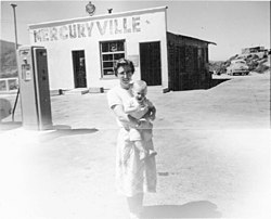
By 1963 the settlement of
Mercuryville had diminished in population to a population of two, and the town then consisted of a gas station/store that doubled as a home for an elderly couple. By this time the nearby Geysers resort was rundown with a main pool and a few smaller gender-segregated pools.
222:
By the mid-1960s the gas station had closed and
Mercuryville had become a ghost town. One of the last remaining large mine buildings was burned in wildfires in the mid-1970s, although some concrete structures and metalwork from the mines remain.
181:
As per the name of the town, mercury was its primary economic engine and there were several mines in the area. The nearby
Socrates Mine, about 5 miles west of Mercuryville, produced mercury-bearing ores including:
377:
214:, the world's largest geothermal energy generation facility that provides 725 megawatts of electricity; it produces enough electricity to power the city of
82:
306:"Detailed mineral report for Socrates Mine, Castle Rock Springs area, West Mayacmas District, Mayacmas Mts (Mayacamas Mts), Sonoma Co., California, USA"
352:
53:
372:
37:
277:
147:
278:"A Homestead Era History of Nunns' Canyon and Calabazas Creek Preserve c.1850 - 1910 Glen Ellen, California"
171:
143:
170:
is a dense liquid metal that can be used to separate gold from other less dense materials. The
167:
255:
225:
366:
215:
117:
211:
175:
151:
305:
195:
191:
166:, a mercury-bearing ore, was discovered in eastern Sonoma County around 1870.
139:
127:
97:
84:
207:
187:
327:
183:
163:
233:
203:
232:
224:
199:
206:. The area has considerable geothermal resources, with active
256:"Sonoma County Historical Society – Sonoma County Timeline"
229:
328:"About Geothermal Energy | Calpine Corporation"
123:
113:
23:
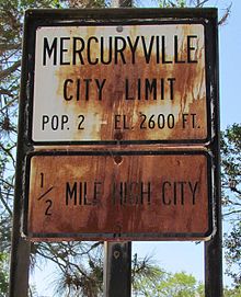
237:Mercuryville City limits road sign from the 1950s
378:Former settlements in Sonoma County, California
194:. The mine also bore other minerals including
8:
355:. Rohnert Park, CA: Sonoma County Library.
20:
162:Mercuryville was founded in 1874, after
247:
112:
77:
46:
34:
29:
122:
7:
60:
210:and hot springs. Located nearby is
18:Place in California, United States
14:
353:"Search Results for mercuryville"
308:. Mindat.org. September 24, 2015
59:
52:
42:The town of Mercuryville in 1956
36:
186:, montroydite, edgarbaileyite,
1:
394:
373:Ghost towns in California
258:. Sonomacountyhistory.org
148:Sonoma County, California
78:
47:
35:
30:
136:Mercuryville, California
31:Mercuryville, California
238:
230:
98:38.77611°N 122.83944°W
236:
228:
172:California Gold Rush
103:38.77611; -122.83944
285:Sonomaopenspace.org
144:Mayacamas Mountains
94: /
239:
231:
133:
132:
385:
357:
356:
349:
343:
342:
340:
338:
324:
318:
317:
315:
313:
302:
296:
295:
293:
291:
282:
274:
268:
267:
265:
263:
252:
109:
108:
106:
105:
104:
99:
95:
92:
91:
90:
87:
63:
62:
56:
40:
21:
393:
392:
388:
387:
386:
384:
383:
382:
363:
362:
361:
360:
351:
350:
346:
336:
334:
326:
325:
321:
311:
309:
304:
303:
299:
289:
287:
280:
276:
275:
271:
261:
259:
254:
253:
249:
244:
160:
102:
100:
96:
93:
88:
85:
83:
81:
80:
74:
73:
72:
71:
70:
69:
68:
64:
43:
26:
19:
12:
11:
5:
391:
389:
381:
380:
375:
365:
364:
359:
358:
344:
319:
297:
269:
246:
245:
243:
240:
159:
156:
131:
130:
125:
121:
120:
115:
111:
110:
76:
75:
66:
65:
58:
57:
51:
50:
49:
48:
45:
44:
41:
33:
32:
28:
27:
24:
17:
13:
10:
9:
6:
4:
3:
2:
390:
379:
376:
374:
371:
370:
368:
354:
348:
345:
333:
329:
323:
320:
307:
301:
298:
286:
279:
273:
270:
257:
251:
248:
241:
235:
227:
223:
219:
217:
216:San Francisco
213:
209:
205:
201:
197:
193:
189:
185:
179:
177:
173:
169:
165:
157:
155:
153:
149:
145:
141:
137:
129:
126:
119:
118:United States
116:
107:
79:Coordinates:
55:
39:
22:
16:
347:
335:. Retrieved
331:
322:
310:. Retrieved
300:
288:. Retrieved
284:
272:
260:. Retrieved
250:
220:
180:
161:
135:
134:
67:Mercuryville
25:Mercuryville
15:
337:October 20,
332:Geysers.com
312:October 20,
262:October 20,
212:the Geysers
176:Guerneville
152:The Geysers
101: /
89:122°50′22″W
367:Categories
242:References
196:chalcedony
192:tiemannite
140:ghost town
128:California
86:38°46′34″N
208:fumaroles
188:magnesite
290:July 19,
184:cinnabar
164:cinnabar
168:Mercury
158:History
142:in the
114:Country
204:pyrite
202:, and
190:, and
154:road.
150:along
281:(PDF)
138:is a
124:State
339:2016
314:2016
292:2019
264:2016
200:opal
146:of
369::
330:.
283:.
218:.
198:,
178:.
341:.
316:.
294:.
266:.
Text is available under the Creative Commons Attribution-ShareAlike License. Additional terms may apply.