38:
106:
404:
416:
440:
73:
428:
53:
113:
80:
365:
Meer Castle was first mentioned in 1314. The oldest parts date from the early-14th century. The current complex was finished by 1570. In 1914, an extensive remodelling was planned, but was only partially executed between 1918 and 1923. The park was laid out in 1852.
643:
352:
The village was first mentioned in the 1170s as de Mere, and means lake. Mheer developed in the Middle Ages on the plateau of
Margraten. A castle was built on the highest point belong to the Land of
785:
809:
804:
636:
37:
105:
629:
613:
285:
297:
403:
141:
653:
561:
427:
369:
The
Catholic St Lambertus is a single aisled church with needle spire. It was built between 1876 and 1877 according to a design by
72:
415:
439:
277:
814:
173:
621:
376:
Mheer was home to 405 people in 1840. It was a separate municipality until 1982, when it was merged with
333:
256:
188:
52:
266:
551:
321:
731:
657:
557:
389:
337:
198:
759:
468:
743:
681:
370:
316:
798:
721:
358:
329:
178:
341:
156:
143:
726:
701:
696:
686:
519:
377:
247:
736:
774:
716:
385:
769:
691:
676:
671:
381:
764:
353:
273:
252:
587:
706:
493:
625:
786:
List of cities, towns and villages in
Limburg (Netherlands)
125:
Location in the province of
Limburg in the Netherlands
752:
664:
296:
284:
263:
246:
238:
230:
225:
217:
209:
204:
194:
184:
172:
21:
550:Sabine Broekhoven, & Ronald Stenvert (2003).
388:. In 2011, it became part of the municipality of
810:Former municipalities of Limburg (Netherlands)
637:
8:
644:
630:
622:
545:
543:
541:
18:
805:Populated places in Limburg (Netherlands)
582:
580:
455:
399:
336:. It is located in the municipality of
283:
245:
224:
216:
203:
171:
136:
64:
46:
34:
463:
461:
459:
614:Repertorium van Nederlandse gemeenten
373:as a replacement of the 1774 church.
315:
295:
262:
237:
229:
208:
193:
183:
7:
469:"Kerncijfers wijken en buurten 2021"
612:Ad van der Meer and Onno Boonstra,
213:4.36 km (1.68 sq mi)
340:and about 12 km southeast of
14:
438:
426:
414:
402:
380:. The municipality also covered
128:Show map of Limburg, Netherlands
111:
104:
78:
71:
51:
36:
500:(in Dutch). Het Waterschapshuis
498:Actueel Hoogtebestand Nederland
433:St Lambertus Church and maypole
16:Village in Limburg, Netherlands
556:(in Dutch). Zwolle: Waanders.
1:
520:"Mheer - (geografische naam)"
112:
79:
473:Central Bureau of Statistics
92:Location in the Netherlands
831:
783:
494:"Postcodetool for 6261NA"
137:
65:
47:
35:
28:
652:Populated places in the
221:170 m (560 ft)
356:. The village became a
242:200/km (510/sq mi)
95:Show map of Netherlands
328:) is a village in the
325:
265: • Summer (
313:Dutch pronunciation:
239: • Density
157:50.78278°N 5.79306°E
153: /
231: • Total
210: • Total
815:Eijsden-Margraten
792:
791:
658:Eijsden-Margraten
390:Eijsden-Margraten
338:Eijsden-Margraten
306:
305:
199:Eijsden-Margraten
162:50.78278; 5.79306
822:
740:
646:
639:
632:
623:
617:
610:
604:
603:
601:
599:
584:
575:
574:
572:
570:
547:
536:
535:
533:
531:
516:
510:
509:
507:
505:
490:
484:
483:
481:
479:
465:
442:
430:
418:
406:
319:
314:
270:
168:
167:
165:
164:
163:
158:
154:
151:
150:
149:
146:
129:
115:
114:
108:
96:
82:
81:
75:
55:
40:
19:
830:
829:
825:
824:
823:
821:
820:
819:
795:
794:
793:
788:
779:
748:
734:
660:
650:
620:
611:
607:
597:
595:
586:
585:
578:
568:
566:
564:
549:
548:
539:
529:
527:
518:
517:
513:
503:
501:
492:
491:
487:
477:
475:
467:
466:
457:
453:
446:
443:
434:
431:
422:
421:Gallow of Mheer
419:
410:
407:
398:
350:
317:[ˈmeːr]
312:
292:
264:
161:
159:
155:
152:
147:
144:
142:
140:
139:
133:
132:
131:
130:
127:
126:
123:
122:
121:
120:
116:
99:
98:
97:
94:
93:
90:
89:
88:
87:
83:
61:
60:
59:
58:
43:
31:
24:
17:
12:
11:
5:
828:
826:
818:
817:
812:
807:
797:
796:
790:
789:
784:
781:
780:
778:
777:
772:
767:
762:
756:
754:
750:
749:
747:
746:
744:Sint Geertruid
741:
729:
724:
719:
714:
709:
704:
699:
694:
689:
684:
682:Cadier en Keer
679:
674:
668:
666:
662:
661:
651:
649:
648:
641:
634:
626:
619:
618:
616:, KNAW, 2011.
605:
576:
562:
537:
524:Etymologiebank
511:
485:
454:
452:
449:
448:
447:
445:House in mheer
444:
437:
435:
432:
425:
423:
420:
413:
411:
408:
401:
397:
394:
371:Pierre Cuypers
349:
346:
304:
303:
300:
294:
293:
290:
288:
282:
281:
271:
261:
260:
250:
244:
243:
240:
236:
235:
232:
228:
227:
223:
222:
219:
215:
214:
211:
207:
206:
202:
201:
196:
192:
191:
186:
182:
181:
176:
170:
169:
135:
134:
124:
118:
117:
110:
109:
103:
102:
101:
100:
91:
85:
84:
77:
76:
70:
69:
68:
67:
66:
63:
62:
56:
50:
49:
48:
45:
44:
41:
33:
32:
29:
26:
25:
22:
15:
13:
10:
9:
6:
4:
3:
2:
827:
816:
813:
811:
808:
806:
803:
802:
800:
787:
782:
776:
773:
771:
768:
766:
763:
761:
758:
757:
755:
751:
745:
742:
738:
733:
730:
728:
725:
723:
722:Oost-Maarland
720:
718:
715:
713:
710:
708:
705:
703:
700:
698:
695:
693:
690:
688:
685:
683:
680:
678:
675:
673:
670:
669:
667:
663:
659:
655:
647:
642:
640:
635:
633:
628:
627:
624:
615:
609:
606:
593:
589:
583:
581:
577:
565:
563:90 400 9623 6
559:
555:
554:
546:
544:
542:
538:
525:
521:
515:
512:
499:
495:
489:
486:
474:
470:
464:
462:
460:
456:
450:
441:
436:
429:
424:
417:
412:
405:
400:
395:
393:
391:
387:
383:
379:
374:
372:
367:
363:
361:
360:
355:
347:
345:
343:
339:
335:
331:
327:
323:
318:
310:
301:
299:
289:
287:
279:
275:
272:
268:
258:
254:
251:
249:
241:
233:
220:
212:
200:
197:
190:
187:
180:
177:
175:
166:
138:Coordinates:
107:
74:
54:
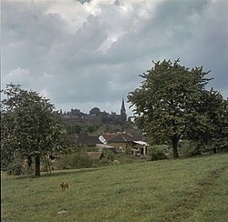
42:View on Mheer
39:
27:
20:
711:
654:municipality
608:
596:. Retrieved
592:Plaatsengids
591:
567:. Retrieved
552:
528:. Retrieved
523:
514:
502:. Retrieved
497:
488:
476:. Retrieved
472:
409:Mheer Castle
375:
368:
364:
359:heerlijkheid
357:
351:
332:province of
308:
307:
298:Dialing code
195:Municipality
57:Coat of arms
735: [
286:Postal code
179:Netherlands
160: /
799:Categories
594:(in Dutch)
526:(in Dutch)
451:References
342:Maastricht
322:Limburgish
226:Population
145:50°46′58″N
732:Scheulder
727:Rijckholt
702:Margraten
697:Gronsveld
687:Eckelrade
378:Margraten
362:in 1564.
248:Time zone
218:Elevation
148:5°47′35″E
775:Terhorst
717:Noorbeek
665:Villages
598:24 April
569:24 April
530:24 April
504:24 April
478:24 April
386:Terhorst
185:Province
770:Honthem
753:Hamlets
692:Eijsden
677:Bemelen
672:Banholt
588:"Mheer"
396:Gallery
382:Banholt
348:History
334:Limburg
189:Limburg
174:Country
30:Village
765:Breust
560:
354:Dalhem
739:]
712:Mheer
707:Mesch
553:Mheer
330:Dutch
309:Mheer
274:UTC+2
253:UTC+1
119:Mheer
86:Mheer
23:Mheer
760:Berg
600:2022
571:2022
558:ISBN
532:2022
506:2022
480:2022
384:and
326:Maer
291:6261
278:CEST
205:Area
656:of
302:043
267:DST
257:CET
234:860
801::
737:nl
590:.
579:^
540:^
522:.
496:.
471:.
458:^
392:.
344:.
324::
320:;
645:e
638:t
631:v
602:.
573:.
534:.
508:.
482:.
311:(
280:)
276:(
269:)
259:)
255:(
Text is available under the Creative Commons Attribution-ShareAlike License. Additional terms may apply.