527:
62:
45:
92:
99:
69:
295:
Miloma was originally called
Prairie Junction, and under the latter name was founded in about 1879 when the railroad was extended to that point. The present name of the community is a double contraction, Milwaukee and Omaha, from the names of two railroads, the Chicago, Milwaukee & Saint Paul and
800:
296:
the
Chicago, Minneapolis & Omaha. A post office was established under the name Prairie Junction in 1881, the name was changed to Miloma in 1906, and the post office closed in 1930.
636:
440:
781:
805:
626:
556:
124:
621:
611:
601:
581:
571:
566:
641:
596:
561:
195:
287:
at latitude 43.763 and longitude -95.368 (Miloma
Panoramio Photos). The elevation is 1,427 feet. Miloma appears on the Heron Lake U.S. Geological Survey Map.
606:
576:
591:
551:
631:
586:
616:
546:
433:
386:
A History of the Origin of the Place Names
Connected with the Chicago & North Western and Chicago, St. Paul, Minneapolis & Omaha Railways
774:
370:
256:
810:
426:
91:
767:
61:
418:
190:
400:
178:
747:
450:
276:
183:
44:
717:
244:
156:
315:
699:
651:
689:
496:
724:
659:
506:
229:
704:
669:
272:
35:
348:
511:
501:
472:
679:
516:
384:
366:
219:
751:
327:
491:
694:
342:
538:
794:
284:
249:
465:
166:
316:
U.S. Geological Survey
Geographic Names Information System: Miloma, Minnesota
139:
126:
280:
210:
171:
526:
344:
Minnesota
Geographic Names: Their Origin and Historic Significance
236:
215:
328:"Miloma Populated Place Profile / Jackson County, Minnesota Data"
483:
422:
525:
801:
Unincorporated communities in
Jackson County, Minnesota
755:
21:
Unincorporated community in
Minnesota, United States
16:
Unincorporated community in
Minnesota, United States
668:
650:
537:
482:
255:
243:
226:
209:
201:
189:
177:
165:
155:
26:
383:Chicago and North Western Railway Company (1908).
775:
434:
8:
530:Map of Minnesota highlighting Jackson County
782:
768:
441:
427:
419:
23:
347:. Minnesota Historical Society. p.
806:Unincorporated communities in Minnesota
305:
254:
242:
208:
200:
154:
119:
53:
41:
311:
309:
225:
188:
176:
164:
7:
743:
741:
363:Edge Effects: The Border-Name Places
754:. You can help Knowledge (XXG) by
449:Municipalities and communities of
365:, (2nd edition, 2009), iUniverse,
14:
746:This article about a location in
97:
90:
67:
60:
43:
98:
68:
1:
111:Show map of the United States
827:
740:
403:. Jim Forte Postal History
205:1,431 ft (436 m)
811:Minnesota geography stubs
748:Jackson County, Minnesota
713:
523:
463:
452:Jackson County, Minnesota
120:
54:
42:
33:
273:unincorporated community
36:Unincorporated community
531:
341:Upham, Warren (1920).
529:
228: • Summer (
140:43.76278°N 95.36833°W
81:Show map of Minnesota
726:United States portal
145:43.76278; -95.36833
136: /
532:
361:Temple, Robert D.
763:
762:
735:
734:
371:978-0-595-47758-6
266:
265:
818:
784:
777:
770:
742:
727:
720:
719:Minnesota portal
528:
475:
468:
458:
453:
443:
436:
429:
420:
413:
412:
410:
408:
401:"Jackson County"
397:
391:
390:
380:
374:
359:
353:
352:
338:
332:
331:
324:
318:
313:
233:
151:
150:
148:
147:
146:
141:
137:
134:
133:
132:
129:
112:
101:
100:
94:
82:
71:
70:
64:
47:
24:
826:
825:
821:
820:
819:
817:
816:
815:
791:
790:
789:
788:
738:
736:
731:
725:
718:
709:
671:
664:
646:
637:West Heron Lake
533:
521:
478:
473:
466:
459:
456:
451:
447:
417:
416:
406:
404:
399:
398:
394:
382:
381:
377:
360:
356:
340:
339:
335:
326:
325:
321:
314:
307:
302:
293:
227:
144:
142:
138:
135:
130:
127:
125:
123:
122:
116:
115:
114:
113:
110:
109:
108:
107:
106:
102:
85:
84:
83:
80:
79:
78:
77:
76:
72:
50:
38:
29:
22:
17:
12:
11:
5:
824:
822:
814:
813:
808:
803:
793:
792:
787:
786:
779:
772:
764:
761:
760:
733:
732:
730:
729:
722:
714:
711:
710:
708:
707:
702:
697:
692:
687:
682:
676:
674:
670:Unincorporated
666:
665:
663:
662:
656:
654:
648:
647:
645:
644:
639:
634:
629:
624:
619:
614:
609:
604:
599:
594:
589:
584:
579:
574:
569:
564:
559:
554:
549:
543:
541:
535:
534:
524:
522:
520:
519:
514:
509:
504:
499:
494:
488:
486:
480:
479:
464:
461:
460:
448:
446:
445:
438:
431:
423:
415:
414:
392:
389:. p. 183.
375:
354:
333:
319:
304:
303:
301:
298:
292:
289:
277:Jackson County
264:
263:
260:
253:
252:
247:
241:
240:
234:
224:
223:
213:
207:
206:
203:
199:
198:
193:
187:
186:
181:
175:
174:
169:
163:
162:
159:
153:
152:
118:
117:
104:
103:
96:
95:
89:
88:
87:
86:
74:
73:
66:
65:
59:
58:
57:
56:
55:
52:
51:
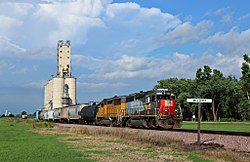
49:Miloma in 2014
48:
40:
39:
34:
31:
30:
27:
20:
15:
13:
10:
9:
6:
4:
3:
2:
823:
812:
809:
807:
804:
802:
799:
798:
796:
785:
780:
778:
773:
771:
766:
765:
759:
757:
753:
749:
744:
739:
728:
723:
721:
716:
715:
712:
706:
703:
701:
698:
696:
693:
691:
688:
686:
683:
681:
678:
677:
675:
673:
667:
661:
658:
657:
655:
653:
649:
643:
640:
638:
635:
633:
630:
628:
625:
623:
620:
618:
615:
613:
610:
608:
605:
603:
600:
598:
595:
593:
590:
588:
585:
583:
580:
578:
575:
573:
570:
568:
565:
563:
560:
558:
555:
553:
550:
548:
545:
544:
542:
540:
536:
518:
515:
513:
510:
508:
505:
503:
500:
498:
495:
493:
490:
489:
487:
485:
481:
477:
476:
469:
462:
457:United States
454:
444:
439:
437:
432:
430:
425:
424:
421:
402:
396:
393:
388:
387:
379:
376:
372:
368:
364:
358:
355:
350:
346:
345:
337:
334:
329:
323:
320:
317:
312:
310:
306:
299:
297:
290:
288:
286:
285:United States
282:
278:
274:
270:
261:
258:
251:
248:
246:
238:
235:
231:
221:
220:Central (CST)
217:
214:
212:
204:
197:
194:
192:
185:
182:
180:
173:
170:
168:
161:United States
160:
158:
149:
121:Coordinates:
93:
63:
46:
37:
32:
25:
19:
756:expanding it
745:
737:
700:Sioux Valley
684:
627:Sioux Valley
471:
405:. Retrieved
395:
385:
378:
362:
357:
343:
336:
322:
294:
268:
267:
18:
672:communities
557:Christiania
467:County seat
373:, page 324.
275:located in
143: /
795:Categories
690:Petersburg
622:Round Lake
612:Petersburg
602:Middletown
582:Heron Lake
572:Enterprise
567:Des Moines
497:Heron Lake
300:References
259:feature ID
131:95°22′06″W
128:43°45′46″N
660:Fish Lake
642:Wisconsin
597:La Crosse
562:Delafield
539:Townships
507:Lakefield
281:Minnesota
245:Area code
211:Time zone
202:Elevation
196:La Crosse
172:Minnesota
705:Spafford
607:Minneota
577:Ewington
407:July 13,
191:Township
592:Kimball
552:Belmont
512:Okabena
502:Jackson
474:Jackson
291:History
184:Jackson
157:Country
685:Miloma
680:Bergen
632:Weimer
587:Hunter
517:Wilder
484:Cities
369:
271:is an
269:Miloma
262:654830
179:County
105:Miloma
75:Miloma
28:Miloma
750:is a
492:Alpha
239:(CDT)
237:UTC-5
216:UTC-6
167:State
752:stub
695:Rost
617:Rost
547:Alba
409:2015
367:ISBN
257:GNIS
652:CDP
349:262
250:507
230:DST
797::
470::
455:,
308:^
283:,
279:,
783:e
776:t
769:v
758:.
442:e
435:t
428:v
411:.
351:.
330:.
232:)
222:)
218:(
Text is available under the Creative Commons Attribution-ShareAlike License. Additional terms may apply.