38:
22:
30:
296:. The "Walnut Tree" and "Browns Wood" sub-areas together cover the remainder of the Rural District from the Ouzel to the M1. The areas covered by these names are far larger than the civil parishes of the same name, except for 'North Milton Keynes', which does not exist otherwise. (The precise boundary mapping is no longer available: the information in the notes below was derived at the time.)
760:
597:
267:
urban and rural districts, subdividing the larger rural district by the chronological phases of urbanisation within them). (These designations were largely dropped for the 2011 Census.) These were:
460:
This area approximated to that of the former
Wolverton Urban District and included Stony Stratford CP, Wolverton and Greenleys CP, New Bradwell CP, Stantonbury CP and part of Great Linford CP.
322:
approximates to the boundaries of the former
Bletchley Urban District Council at the time of the designation of Milton Keynes. In outline, the ONS Sub-area consisted of
736:
703:
670:
637:
550:
171:
after deducting
Bletchley, which has been part of the city since its designation in 1967. The ONS does not give any reason for having done this. Also includes
334:
Civil Parish (specifically
Furzton, Emerson Valley, Tattenhoe and Snelshall) making it rather larger than the commonly understood boundaries of Bletchley.
796:
497:
119:
At the 2021 census, the population of Milton Keynes's Built-up Area was 264,349, an increase of 11.5% over the figure of 229,941 recorded at the
139:
As of June 2023, information about the definitions and populations of the built-up area subdivisions of the 2021 census has yet to be released.
292:
The
Central and North Milton Keynes enumeration districts covered that part of the former Newport Pagnell Rural District that is west of the
97:
441:
This area covered approximately the districts within an area bounded by the River Ouzel, Standing Way, the former A5130, and
Bletcham Way. (
770:. Census 2001: Key statistics for urban areas in the South East (part 1) (Report). Office for National Statistics. 2004. p. 23.
480:
At that time, Woburn Sands was not contiguous with the rest of the urban area and thus is not included. Its population was 4,963.
840:
604:
286:
281:
81:
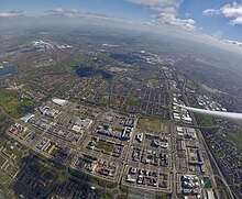
345:
This area covered approximately the districts within an area bounded by the Ouzel, Bletcham Way, the former A5130, and the
784:
323:
187:
724:
691:
658:
625:
538:
442:
131:
These are the 'built-up area subdivisions' of the Milton Keynes urban area (built-up area) as defined by the ONS.
120:
383:
This sub-area is the same as that of the former
Newport Pagnell urban district, excluding any part west of the
276:
271:
89:
728:
695:
662:
629:
542:
407:
403:
399:
49:
835:
37:
21:
446:
369:
354:
231:
41:
123:. That in turn was an increase of almost 25% on the population recorded in the 2001 census of 184,506.
45:
263:
In defining the sub-areas of the Milton Keynes urban area for the 2001 census, the ONS used the
346:
331:
235:
198:
101:
327:
191:
93:
29:
829:
419:
415:
264:
168:
113:
85:
53:
227:
223:
219:
210:
109:
105:
411:
384:
350:
293:
57:
61:
811:
798:
571:
65:
427:
368:
The
Central Milton Keynes urban sub-area covered an area far larger than
172:
100:
for development. The wider urban area outside that designation includes
398:
The North Milton Keynes urban sub-area consisted of the modern part of
423:
25:
Milton Keynes Built-up area and its subdivisions (2011 definitions)
36:
496:
For the ONS definition of a 'built-up area' or 'urban area', see
387:(which the ONS allocated to the "North Milton Keynes" sub-area).
598:"Census 2001 Key Statistics, Urban areas in England and Wales"
543:"Local Area Report – Milton Keynes Built-up area (E34005056)"
175:, which is outside the designated area of Milton Keynes.
630:"Local Area Report – Rest of Milton Keynes (E35001516)"
349:. (The area concerned is substantially larger than the
80:
is a designation established by the United
Kingdom's
498:
List of urban areas in the United
Kingdom#Definition
33:
Population trend of Borough and Urban Area 1801–2021
696:"Local Area Report – Newport Pagnell (E35001223)"
572:"UNITED KINGDOM: Countries and Major Urban Areas"
729:"Local Area Report – Woburn Sands (E35000347)"
445:is a (substantially smaller) neighbourhood of
299:The corresponding 2001 Urban Sub-areas were:
8:
663:"Local Area Report – Bletchley (E35000902)"
301:
146:
28:
20:
521:
489:
755:
753:
16:Settlement in Buckinghamshire, England
533:
531:
529:
527:
525:
98:Milton Keynes Development Corporation
7:
167:This figure is for the remainder of
14:
44:from the air, looking south. The
88:has no statutory boundary: the
765:KS01 Usual resident population"
52:mark the right of the picture,
737:Office for National Statistics
704:Office for National Statistics
671:Office for National Statistics
638:Office for National Statistics
551:Office for National Statistics
454:Wolverton and Stony Stratford
287:Newport Pagnell Rural District
282:Newport Pagnell Urban District
82:Office for National Statistics
68:are at the top of the picture.
1:
324:Bletchley and Fenny Stratford
188:Bletchley and Fenny Stratford
127:Built-up area sub-divisions
112:(Bedfordshire) and part of
78:Milton Keynes Built-up Area
857:
330:Civil Parish and part of
308:Population (2001 census)
218:Includes the villages of
153:Population (2011 census)
277:Wolverton Urban District
272:Bletchley Urban District
230:, which lie outside the
74:Milton Keynes urban area
841:Urban areas of England
362:Central Milton Keynes
69:
34:
26:
370:Central Milton Keynes
232:City of Milton Keynes
42:Central Milton Keynes
40:
32:
24:
812:52.07476°N 0.73450°W
392:North Milton Keynes
90:1967 designated area
46:West Coast Main Line
808: /
786:A Vision of Britain
817:52.07476; -0.73450
578:. 11 November 2022
186:Civil parishes of
70:
35:
27:
576:citypopulation.de
478:
477:
347:Marston Vale line
332:Shenley Brook End
256:
255:
94:the area assigned
60:are to the left.
848:
823:
822:
820:
819:
818:
813:
809:
806:
805:
804:
801:
772:
771:
769:
764:
757:
748:
747:
745:
743:
721:
715:
714:
712:
710:
688:
682:
681:
679:
677:
655:
649:
648:
646:
644:
622:
616:
615:
613:
611:
602:
594:
588:
587:
585:
583:
568:
562:
561:
559:
557:
535:
509:
506:
500:
494:
377:Newport Pagnell
302:
161:"Milton Keynes"
147:
92:only determined
856:
855:
851:
850:
849:
847:
846:
845:
826:
825:
816:
814:
810:
807:
802:
799:
797:
795:
794:
788:- Milton Keynes
781:
776:
775:
767:
762:
759:
758:
751:
741:
739:
723:
722:
718:
708:
706:
690:
689:
685:
675:
673:
657:
656:
652:
642:
640:
624:
623:
619:
609:
607:
600:
596:
595:
591:
581:
579:
570:
569:
565:
555:
553:
537:
536:
523:
518:
513:
512:
507:
503:
495:
491:
486:
408:Bradwell Common
353:grid-square in
265:pre-designation
261:
236:Buckinghamshire
199:Newport Pagnell
145:
137:
129:
102:Newport Pagnell
17:
12:
11:
5:
854:
852:
844:
843:
838:
828:
827:
792:
791:
780:
779:External links
777:
774:
773:
749:
716:
683:
650:
617:
589:
563:
520:
519:
517:
514:
511:
510:
501:
488:
487:
485:
482:
476:
475:
473:
468:
462:
461:
458:
455:
451:
450:
439:
436:
432:
431:
396:
393:
389:
388:
381:
378:
374:
373:
372:civil parish.
366:
363:
359:
358:
343:
340:
336:
335:
328:West Bletchley
326:Civil Parish,
320:
317:
313:
312:
309:
306:
290:
289:
284:
279:
274:
260:
257:
254:
253:
251:
246:
240:
239:
216:
213:
207:
206:
204:
201:
195:
194:
192:West Bletchley
184:
181:
177:
176:
165:
162:
158:
157:
154:
151:
144:
141:
136:
133:
128:
125:
116:civil parish.
15:
13:
10:
9:
6:
4:
3:
2:
853:
842:
839:
837:
836:Milton Keynes
834:
833:
831:
824:
821:
789:
787:
783:
782:
778:
766:
756:
754:
750:
738:
734:
730:
726:
720:
717:
705:
701:
697:
693:
687:
684:
672:
668:
664:
660:
654:
651:
639:
635:
631:
627:
621:
618:
606:
599:
593:
590:
577:
573:
567:
564:
552:
548:
544:
540:
534:
532:
530:
528:
526:
522:
515:
505:
502:
499:
493:
490:
483:
481:
474:
472:
469:
467:
464:
463:
459:
456:
453:
452:
448:
444:
440:
437:
434:
433:
429:
425:
421:
420:Downhead Park
417:
413:
409:
405:
401:
397:
394:
391:
390:
386:
382:
379:
376:
375:
371:
367:
364:
361:
360:
356:
352:
348:
344:
341:
338:
337:
333:
329:
325:
321:
318:
315:
314:
310:
307:
304:
303:
300:
297:
295:
288:
285:
283:
280:
278:
275:
273:
270:
269:
268:
266:
258:
252:
250:
247:
245:
242:
241:
237:
233:
229:
225:
221:
217:
214:
212:
209:
208:
205:
202:
200:
197:
196:
193:
189:
185:
182:
179:
178:
174:
170:
169:Milton Keynes
166:
163:
160:
159:
155:
152:
149:
148:
142:
140:
134:
132:
126:
124:
122:
117:
115:
114:Stoke Hammond
111:
107:
103:
99:
95:
91:
87:
86:Milton Keynes
83:
79:
75:
67:
63:
59:
55:
54:Campbell Park
51:
47:
43:
39:
31:
23:
19:
793:
785:
740:. Retrieved
732:
719:
707:. Retrieved
699:
686:
674:. Retrieved
666:
653:
641:. Retrieved
633:
620:
608:. Retrieved
592:
580:. Retrieved
575:
566:
554:. Retrieved
546:
504:
492:
479:
470:
465:
435:Walnut Tree
412:Linford Wood
339:Browns Wood
305:Subdivision
298:
291:
262:
248:
243:
228:Bedfordshire
224:Aspley Heath
220:Aspley Guise
211:Woburn Sands
180:"Bletchley"
150:Subdivision
138:
130:
118:
110:Aspley Guise
106:Woburn Sands
77:
73:
71:
18:
815: /
582:23 November
443:Walnut Tree
385:M1 Motorway
351:Browns Wood
294:River Ouzel
121:2011 census
108:as well as
58:Willen Lake
830:Categories
800:52°04′29″N
516:References
416:Downs Barn
414:, half of
406:, half of
316:Bletchley
62:Stadium MK
803:0°44′04″W
742:1 January
725:UK Census
709:1 January
692:UK Census
676:1 January
659:UK Census
643:1 January
626:UK Census
539:UK Census
66:Bletchley
727:(2011).
694:(2011).
661:(2011).
628:(2011).
556:29 March
541:(2011).
428:Tongwell
404:Rooksley
400:Bradwell
173:Wavendon
164:171,750
48:and the
508:page 31
471:184,506
457:60,359
438:12,526
395:13,489
380:14,739
365:31,442
319:47,176
249:229,941
203:15,118
183:37,114
96:to the
763:
761:"Table
610:3 July
447:Walton
424:Willen
355:Walton
342:4,225
311:Notes
215:5,959
156:Notes
768:(PDF)
733:Nomis
700:Nomis
667:Nomis
634:Nomis
601:(PDF)
547:Nomis
484:Notes
466:Total
449:CP.)
357:CP.)
244:Total
234:(and
744:2019
711:2019
678:2019
645:2019
612:2013
584:2022
558:2019
426:and
259:2001
222:and
190:and
143:2011
135:2021
104:and
72:The
64:and
56:and
605:ONS
226:in
84:.
76:or
832::
752:^
735:.
731:.
702:.
698:.
669:.
665:.
636:.
632:.
603:.
574:.
549:.
545:.
524:^
430:.
422:,
418:,
410:,
402:,
238:)
50:A5
790:.
746:.
713:.
680:.
647:.
614:.
586:.
560:.
Text is available under the Creative Commons Attribution-ShareAlike License. Additional terms may apply.