49:
276:
364:
187:
199:
29:
56:
310:
origin, meaning "a lot of waterfowl" but other meanings are also thought possible. It appears officially in the eighteenth century in the concession document made on April 6, 1733 to Paul-Louis de
Lusignan Dazemard as the "Missiskouy Bay". The spelling has changed several times. In 1855, when changes
347:
The bay has a great diversity of fauna and flora, including many species of birds, hence the establishment of a national refuge on the US side. Its beaches are very popular with vacationers in summer and its waters attract various activities, especially
339:. Until the late 2000s, the water of the bay was stagnant and the bay was dying. At the opening of the new bridge on the US side, the old road causeway was partly demolished which brought a flow of fresh water from Lake Champlain.
331:
approximately 8,000 years ago. The maximum depth of the bay is about 4.75 m and its bottom is made of regional marine deposits. The bay waters drain south into the
243:. It takes the form of a violin head, with the neck extending from the head of the lake and is about 5 kilometres (3.1 mi) in diameter. The bay is divided between
401:
91:
48:
499:
264:
489:
152:
494:
383:
260:
77:
291:
on the lake following the boundary of 1739; indication of the course of water and rapids. This card identifies the
377:
504:
484:
275:
160:
456:
423:
349:
299:
145:
469:
389:
336:
240:
171:
395:
332:
280:
236:
178:
167:
138:
34:
478:
369:
328:
256:
204:
123:
312:
327:
Glaciers grounded in the Bay 18,000 years ago and then melted there forming the
288:
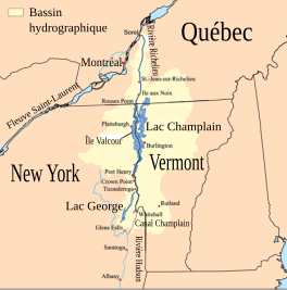
263:, a major summer resort. The river of the same name flows into the bay and the
359:
303:
284:
28:
106:
93:
464:
307:
252:
146:
295:
and the lordships bordering the bay, including that of Mr de
Lusignan.
161:
248:
244:
192:
315:
into electoral districts, the
Legislature finally adopts the form
274:
352:, boats, etc. In winter, anglers engage in ice fishing activity.
470:
Site officiel du refuge faunique national de la baie
Missisquoi
306:, was the first European to visit the region. The name has an
128:
431:. Granby, Que.: Granby Printing and Publishing Co. Ltd
386:, a stream (fr: Rivière aux Brochets (baie Missisquoi)
380:, a stream (fr: Rivière aux Brochets (baie Missisquoi)
222:
214:
210:
177:
159:
144:
134:
122:
83:
73:
37:
with
Missisquoi Bay in North-East area of the lake.
21:
283:from Fort Chambly seen over Fort St Frederic, in
84:
239:, at the East of the output of the latter in
235:is a large extension in the northern part of
8:
18:
287:". Cadastral map showing concessions and
319:to designate the county and the region.
414:
402:Rivière-aux-Brochets Ecological Reserve
153:Rivière aux Brochets (baie Missisquoi)
55:
7:
265:Missisquoi National Wildlife Refuge
14:
384:Pike River North (Missisquoi Bay)
267:is located on the American side.
425:Missisquoi Bay (Philipsburg, Que
362:
259:. The main town on its banks is
197:
185:
54:
47:
27:
221:
213:
422:Montgomery, George H. (1950).
1:
457:Le Wiki de la Baie Missisquoi
72:
465:Conservation Baie Missisquoi
155:Pikes River (Missisquoi Bay)
378:Pike River (Missisquoi Bay)
521:
226:4.75 m (15.6 ft)
490:Bays of the United States
311:to electoral counties of
42:
26:
500:Landforms of Montérégie
218:5 km (3.1 mi)
16:Bay in Venise-en-Québec
296:
278:
107:45.02000°N 73.14500°W
495:Geography of Vermont
302:, first governor of
350:personal watercraft
112:45.02000; -73.14500
103: /
297:
398:, a body of water
230:
229:
512:
463:
455:
441:
440:
438:
436:
430:
419:
372:
367:
366:
365:
261:Venise-en-Québec
203:
201:
200:
191:
189:
188:
163:
162:Primary outflows
148:
118:
117:
115:
114:
113:
108:
104:
101:
100:
99:
96:
86:
78:Venise-en-Québec
58:
57:
51:
31:
19:
520:
519:
515:
514:
513:
511:
510:
509:
475:
474:
461:
453:
450:
445:
444:
434:
432:
428:
421:
420:
416:
411:
390:Richelieu River
368:
363:
361:
358:
345:
337:Richelieu River
325:
273:
241:Richelieu River
198:
196:
195:
186:
184:
181: countries
172:Richelieu River
147:Primary inflows
111:
109:
105:
102:
97:
94:
92:
90:
89:
69:
68:
67:
66:
65:
64:
63:
59:
38:
17:
12:
11:
5:
518:
516:
508:
507:
505:Lake Champlain
502:
497:
492:
487:
485:Bays of Quebec
477:
476:
473:
472:
467:
459:
449:
448:External links
446:
443:
442:
413:
412:
410:
407:
406:
405:
399:
396:Lake Champlain
393:
387:
381:
374:
373:
357:
354:
344:
341:
333:Champlain Lake
324:
321:
293:Michiscouy Bay
281:Lake Champlain
272:
269:
237:Lake Champlain
233:Missisquoi Bay
228:
227:
224:
220:
219:
216:
212:
211:
208:
207:
182:
175:
174:
168:Champlain Lake
165:
157:
156:
150:
142:
141:
139:Champlain Lake
136:
132:
131:
126:
120:
119:
87:
81:
80:
75:
71:
70:
62:Missisquoi Bay
61:
60:
53:
52:
46:
45:
44:
43:
40:
39:
35:Lake Champlain
32:
24:
23:
22:Missisquoi Bay
15:
13:
10:
9:
6:
4:
3:
2:
517:
506:
503:
501:
498:
496:
493:
491:
488:
486:
483:
482:
480:
471:
468:
466:
460:
458:
452:
451:
447:
427:
426:
418:
415:
408:
403:
400:
397:
394:
391:
388:
385:
382:
379:
376:
375:
371:
370:Canada portal
360:
355:
353:
351:
342:
340:
338:
334:
330:
329:Champlain Sea
322:
320:
318:
314:
309:
305:
301:
294:
290:
286:
282:
277:
270:
268:
266:
262:
258:
257:United States
254:
250:
246:
242:
238:
234:
225:
217:
209:
206:
205:United States
194:
183:
180:
176:
173:
169:
166:
164:
158:
154:
151:
149:
143:
140:
137:
133:
130:
127:
125:
121:
116:
88:
82:
79:
76:
50:
41:
36:
30:
25:
20:
433:. Retrieved
424:
417:
346:
326:
316:
313:Lower Canada
298:
292:
232:
231:
135:Part of
462:(in French)
454:(in French)
343:Environment
289:seigneuries
215:Max. length
110: /
85:Coordinates
479:Categories
435:January 9,
409:References
392:, a stream
317:Missisquoi
304:New France
285:New France
223:Max. depth
98:73°08′42″W
95:45°01′12″N
300:Champlain
356:See also
335:and the
279:"Map of
271:Toponymy
74:Location
404:, a bay
323:Geology
308:Abenaki
255:in the
253:Vermont
33:Map of
249:Canada
245:Quebec
202:
193:Canada
190:
429:(PDF)
179:Basin
437:2017
251:and
170:and
124:Type
247:in
129:Bay
481::
439:.
Text is available under the Creative Commons Attribution-ShareAlike License. Additional terms may apply.