111:
896:
98:
76:
51:
1471:
985:
66:
725:
669:, and is still considered part of to the Greater Kitakyushu Metropolitan Area. Kaijima Coal Mine, the largest coal mine in Chikuho was located in the former Miyata Town. However, as the demand for coal decreased due to the energy revolution, the coal mines that had sponsored prosperity have closed, leading to depopulation. The last coal mine closed by 1976. After the coal mine closed, an
845:
118:
456:) characterized by warm summers and cool winters with light to no snowfall. The average annual temperature in Miyawaka is 15.4 °C. The average annual rainfall is 1560 mm with September as the wettest month. The temperatures are highest on average in August, at around 26.7 °C, and lowest in January, at around 4.2 °C.
384:
City and
Fukuoka City, and belongs to both the Kitakyushu Metropolitan Area and the Fukuoka Metropolitan Area. It is approximately 35 kilometers northeast of Fukuoka City and approximately 35 kilometers southwest of Kitakyushu. Historically, it is an area that has had strong ties with Munakata since
621:, the villages of Wakaymiya and Miyata were established on May 1, 1889 with the creation of the modern municipalities system. Miyata was raised to town status on April 1, 1926 and Wakamiya on February 11, 1943. The two towns merged on February 11, 2006 to form the city of Miyawaka.
693:
Miyawaka has five public elementary schools and two public junior high schools operated by the city government and one public high school operated by the
Fukuoka Prefectural Board of Education.
794:
110:
685:
models. Many automobile industry-related factories are now located in the city, making it one of the leading industrial cities in the
Kitakyushu industrial area.
1508:
895:
380:
Miyawaka is located in the northern
Chikuho region and western Naokura district of Fukuoka Prefecture. It is located south of Munakata City, between
1527:
1455:
142:
1033:
885:
646:
1028:
97:
752:
A firefly festival is held at
Nishikura no Oka Sports Park. At the beginning of June, many fireflies dance around the whole park.
1532:
1038:
75:
984:
1023:
50:
1501:
1013:
863:
1234:
815:
849:
1018:
665:, Miyawaka, along with the municipalities of the Chikuho area, developed with the Kitakyushu industrial zone through
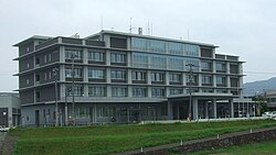
641:
contributes one member to the
Fukuoka Prefectural Assembly. In terms of national politics, the city is part of the
65:
1494:
1217:
913:
449:
1008:
1395:
1356:
1339:
1310:
1268:
769:
638:
182:
782:
1437:
1368:
1256:
950:
1327:
878:
1052:
965:
642:
194:
1239:
1091:
940:
678:
262:
1470:
1227:
1332:
1249:
1201:
970:
955:
945:
899:
369:
357:
199:
1425:
1293:
1156:
397:
1442:
1420:
1378:
1283:
1273:
1222:
1196:
1171:
1166:
1161:
1146:
1141:
1111:
960:
728:
711:
674:
618:
594:
427:
422:
407:
372:
of 190 persons per km². The total area of the city is 139.99 km (54.05 sq mi).
1478:
1405:
1383:
1244:
1101:
1096:
1086:
1076:
871:
417:
1415:
1373:
1349:
1320:
1315:
1278:
1261:
1181:
1151:
1131:
1116:
1106:
670:
606:
437:
432:
402:
353:
309:
41:
1361:
1430:
1410:
1344:
1288:
1186:
1081:
932:
740:
614:
1521:
1388:
1126:
1121:
650:
630:
412:
1400:
1303:
1298:
662:
710:
Miyata Line in
December 1989, the city not had any passenger railway service. The
1176:
666:
602:
598:
993:
634:
610:
381:
365:
258:
637:
city council of 16 members. Miyawaka、collectively with the municipalities of
157:
144:
707:
253:
844:
714:
runs through the city, but there are no stations within the city limits.
795:"Affiliates (Toyota wholly-owned subsidiaries)-Toyota Motor Kyushu, Inc"
923:
908:
464:
Per
Japanese census data, the population of Miyawaka is as shown below
1060:
320:
187:
682:
361:
283:
855:
1191:
481:
867:
677:
in an effort to attract new industries. Since
February 1991,
364:. As of 31 January 2024, the city had an estimated
476:
1482:
783:
Miyawaka climate: Average
Temperature, weather by month
633:
form of government with a directly elected mayor and a
681:
has been based in Miyawaka, building both Toyota and
1210:
1069:
1051:
1001:
992:
931:
922:
316:
304:
277:
269:
252:
244:
236:
231:
223:
218:
210:
205:
193:
181:
173:
21:
673:was created near the Wakamiya Interchange on the
343:
273:29-1 Miyata, Miyawaka-shi, Fukuoka-ken 823-0011
1477:This Fukuoka Prefecture location article is a
337:
28:
1502:
879:
8:
467:
1509:
1495:
998:
928:
886:
872:
864:
466:
90:Location of Miyawaka in Fukuoka Prefecture
18:
593:The area of Miyawaka was part of ancient
761:
299:
276:
268:
251:
230:
217:
204:
172:
137:
103:
87:
59:
47:
368:of 26,447 in 13369 households, and a
227:139.99 km (54.05 sq mi)
1456:List of mergers in Fukuoka Prefecture
706:Following the discontinuation of the
315:
303:
243:
235:
222:
209:
192:
180:
94:
7:
1467:
1465:
214:Hidetoshi Shiokawa (from March 2022)
770:"Miyawaka City official statistics"
1481:. You can help Knowledge (XXG) by
613:the area was under the control of
14:
1469:
983:
894:
843:
797:. Toyota Motor Corporation. 2012
723:
117:
116:
109:
96:
74:
64:
49:
856:Miyawaka City official website
1:
1528:Cities in Fukuoka Prefecture
816:"Miyawaka Firefly Festival"
344:
1549:
1464:
597:, and is mentioned in the
389:Neighboring municipalities
1453:
981:
906:
494:—
450:humid subtropical climate
338:
326:
300:
295:
291:
138:
104:
95:
88:
60:
48:
39:
29:
743:, National Historic Site
639:Kurate District, Fukuoka
605:sources as territory of
25:
1533:Fukuoka geography stubs
248:190/km (490/sq mi)
158:33.72361°N 130.66750°E
772:(in Japanese). Japan.
468:Historical population
16:City in Kyushu, Japan
852:at Wikimedia Commons
643:Fukuoka 8th district
245: • Density
820:crossroadfukuoka.jp
679:Toyota Motor Kyushu
469:
393:Fukuoka Prefecture
163:33.72361; 130.66750
154: /
900:Fukuoka Prefecture
370:population density
237: • Total
224: • Total
211: • Mayor
55:Miyawaka city hall
1490:
1489:
1462:
1461:
1047:
1046:
979:
978:
917:
850:Miyawaka, Fukuoka
848:Media related to
735:Local attractions
729:Kyushu Expressway
712:Kyushu Shinkansen
675:Kyushu Expressway
619:Meiji restoration
595:Chikuzen Province
586:
585:
330:
329:
270:City hall address
130:Location in Japan
1540:
1511:
1504:
1497:
1473:
1466:
1235:Chikujō District
1218:Asakura District
999:
987:
929:
911:
898:
888:
881:
874:
865:
860:
847:
831:
830:
828:
826:
812:
806:
805:
803:
802:
791:
785:
780:
774:
773:
766:
727:
726:
483:
478:
470:
351:
350:
347:
341:
340:
287:
286:
284:Official website
169:
168:
166:
165:
164:
159:
155:
152:
151:
150:
147:
120:
119:
113:
100:
78:
68:
53:
34:
33:
32:
31:
19:
1548:
1547:
1543:
1542:
1541:
1539:
1538:
1537:
1518:
1517:
1516:
1515:
1463:
1458:
1449:
1396:Tagawa District
1357:Mizuma District
1340:Miyako District
1311:Kurate District
1269:Kasuya District
1206:
1065:
1043:
988:
975:
918:
902:
892:
858:
840:
835:
834:
824:
822:
814:
813:
809:
800:
798:
793:
792:
788:
781:
777:
768:
767:
763:
758:
750:
737:
724:
720:
704:
699:
691:
671:industrial park
659:
629:Miyawaka has a
627:
607:Munakata Shrine
591:
462:
448:Miyawaka has a
446:
391:
385:ancient times.
378:
348:
335:
310:Lycoris radiata
282:
281:
162:
160:
156:
153:
148:
145:
143:
141:
140:
134:
133:
132:
131:
128:
127:
126:
125:
121:
91:
84:
83:
82:
81:
72:
71:
56:
44:
35:
27:
26:
24:
17:
12:
11:
5:
1546:
1544:
1536:
1535:
1530:
1520:
1519:
1514:
1513:
1506:
1499:
1491:
1488:
1487:
1474:
1460:
1459:
1454:
1451:
1450:
1448:
1447:
1446:
1445:
1435:
1434:
1433:
1428:
1423:
1418:
1413:
1408:
1403:
1393:
1392:
1391:
1386:
1381:
1376:
1366:
1365:
1364:
1354:
1353:
1352:
1347:
1337:
1336:
1335:
1325:
1324:
1323:
1318:
1308:
1307:
1306:
1301:
1296:
1291:
1286:
1281:
1276:
1266:
1265:
1264:
1254:
1253:
1252:
1247:
1242:
1232:
1231:
1230:
1225:
1214:
1212:
1208:
1207:
1205:
1204:
1199:
1194:
1189:
1184:
1179:
1174:
1169:
1164:
1159:
1154:
1149:
1144:
1139:
1134:
1129:
1124:
1119:
1114:
1109:
1104:
1099:
1094:
1089:
1084:
1079:
1073:
1071:
1067:
1066:
1064:
1063:
1057:
1055:
1049:
1048:
1045:
1044:
1042:
1041:
1036:
1031:
1026:
1021:
1016:
1011:
1005:
1003:
996:
990:
989:
982:
980:
977:
976:
974:
973:
968:
963:
958:
953:
948:
943:
937:
935:
926:
920:
919:
907:
904:
903:
893:
891:
890:
883:
876:
868:
862:
861:
853:
839:
838:External links
836:
833:
832:
807:
786:
775:
760:
759:
757:
754:
749:
746:
745:
744:
741:Takehara Kofun
736:
733:
732:
731:
719:
716:
703:
700:
698:
697:Transportation
695:
690:
687:
658:
655:
626:
623:
615:Fukuoka Domain
590:
587:
584:
583:
580:
577:
573:
572:
569:
566:
562:
561:
558:
555:
551:
550:
547:
544:
540:
539:
536:
533:
529:
528:
525:
522:
518:
517:
514:
511:
507:
506:
503:
500:
496:
495:
492:
489:
485:
484:
479:
474:
461:
458:
445:
442:
441:
440:
435:
430:
425:
420:
415:
410:
405:
400:
390:
387:
377:
374:
328:
327:
324:
323:
318:
314:
313:
306:
302:
301:
298:
297:
293:
292:
289:
288:
279:
275:
274:
271:
267:
266:
256:
250:
249:
246:
242:
241:
238:
234:
233:
229:
228:
225:
221:
220:
216:
215:
212:
208:
207:
203:
202:
197:
191:
190:
185:
179:
178:
175:
171:
170:
136:
135:
129:
123:
122:
115:
114:
108:
107:
106:
105:
102:
101:
93:
92:
89:
86:
85:
79:
73:
69:
63:
62:
61:
58:
57:
54:
46:
45:
40:
37:
36:
22:
15:
13:
10:
9:
6:
4:
3:
2:
1545:
1534:
1531:
1529:
1526:
1525:
1523:
1512:
1507:
1505:
1500:
1498:
1493:
1492:
1486:
1484:
1480:
1475:
1472:
1468:
1457:
1452:
1444:
1441:
1440:
1439:
1438:Yame District
1436:
1432:
1429:
1427:
1424:
1422:
1419:
1417:
1414:
1412:
1409:
1407:
1404:
1402:
1399:
1398:
1397:
1394:
1390:
1387:
1385:
1382:
1380:
1377:
1375:
1372:
1371:
1370:
1369:Onga District
1367:
1363:
1360:
1359:
1358:
1355:
1351:
1348:
1346:
1343:
1342:
1341:
1338:
1334:
1331:
1330:
1329:
1326:
1322:
1319:
1317:
1314:
1313:
1312:
1309:
1305:
1302:
1300:
1297:
1295:
1292:
1290:
1287:
1285:
1282:
1280:
1277:
1275:
1272:
1271:
1270:
1267:
1263:
1260:
1259:
1258:
1257:Kaho District
1255:
1251:
1248:
1246:
1243:
1241:
1238:
1237:
1236:
1233:
1229:
1226:
1224:
1221:
1220:
1219:
1216:
1215:
1213:
1209:
1203:
1200:
1198:
1195:
1193:
1190:
1188:
1185:
1183:
1180:
1178:
1175:
1173:
1170:
1168:
1165:
1163:
1160:
1158:
1155:
1153:
1150:
1148:
1145:
1143:
1140:
1138:
1135:
1133:
1130:
1128:
1125:
1123:
1120:
1118:
1115:
1113:
1110:
1108:
1105:
1103:
1100:
1098:
1095:
1093:
1090:
1088:
1085:
1083:
1080:
1078:
1075:
1074:
1072:
1068:
1062:
1059:
1058:
1056:
1054:
1050:
1040:
1037:
1035:
1034:Yahatahigashi
1032:
1030:
1027:
1025:
1022:
1020:
1017:
1015:
1012:
1010:
1007:
1006:
1004:
1000:
997:
995:
991:
986:
972:
969:
967:
964:
962:
959:
957:
954:
952:
949:
947:
944:
942:
939:
938:
936:
934:
930:
927:
925:
921:
915:
910:
905:
901:
897:
889:
884:
882:
877:
875:
870:
869:
866:
859:(in Japanese)
857:
854:
851:
846:
842:
841:
837:
821:
817:
811:
808:
796:
790:
787:
784:
779:
776:
771:
765:
762:
755:
753:
747:
742:
739:
738:
734:
730:
722:
721:
717:
715:
713:
709:
701:
696:
694:
688:
686:
684:
680:
676:
672:
668:
664:
656:
654:
652:
651:Diet of Japan
648:
644:
640:
636:
632:
631:mayor-council
624:
622:
620:
617:. After the
616:
612:
609:. During the
608:
604:
600:
596:
588:
581:
578:
575:
574:
570:
567:
564:
563:
559:
556:
553:
552:
548:
545:
542:
541:
537:
534:
531:
530:
526:
523:
520:
519:
515:
512:
509:
508:
504:
501:
498:
497:
493:
490:
487:
486:
480:
475:
472:
471:
465:
459:
457:
455:
451:
443:
439:
436:
434:
431:
429:
426:
424:
421:
419:
416:
414:
411:
409:
406:
404:
401:
399:
396:
395:
394:
388:
386:
383:
375:
373:
371:
367:
363:
359:
355:
346:
334:
325:
322:
319:
312:
311:
307:
294:
290:
285:
280:
272:
264:
260:
257:
255:
247:
239:
226:
213:
201:
198:
196:
189:
186:
184:
176:
167:
139:Coordinates:
112:
99:
77:
67:
52:
43:
38:
20:
1483:expanding it
1476:
1328:Mii District
1136:
1029:Kokuraminami
823:. Retrieved
819:
810:
799:. Retrieved
789:
778:
764:
751:
705:
692:
663:Meiji period
660:
628:
592:
463:
460:Demographics
453:
447:
392:
379:
345:Miyawaka-shi
332:
331:
308:
1039:Yahatanishi
667:coal mining
661:During the
647:lower house
603:Nara period
599:Nihon Shoki
356:located in
161: /
149:130°40′03″E
1522:Categories
1092:Chikushino
1024:Kokurakita
994:Kitakyushu
801:2014-02-14
756:References
635:unicameral
625:Government
611:Edo Period
601:and other
382:Kitakyushu
366:population
232:Population
206:Government
195:Prefecture
146:33°43′25″N
1333:Tachiarai
1250:Yoshitomi
1211:Districts
1202:Yukuhashi
1053:Core city
1014:Wakamatsu
748:Festivals
708:JR Kyushu
689:Education
376:Geography
259:UTC+09:00
254:Time zone
1443:Hirokawa
1421:Kawasaki
1379:Mizumaki
1284:Sasaguri
1274:Hisayama
1223:Chikuzen
1197:Yanagawa
1147:Nakagawa
1142:Munakata
1137:Miyawaka
1112:Itoshima
825:12 April
718:Highways
702:Railways
452:(Köppen
428:Hisayama
423:Sasaguri
408:Munakata
333:Miyawaka
124:Miyawaka
23:Miyawaka
1406:Fukuchi
1384:Okagaki
1240:Chikujō
1102:Fukutsu
1097:Dazaifu
1087:Chikugo
1077:Asakura
941:Higashi
924:Fukuoka
914:capital
909:Fukuoka
657:Economy
649:of the
645:of the
589:History
444:Climate
418:Fukutsu
358:Fukuoka
296:Symbols
278:Website
200:Fukuoka
174:Country
1416:Kawara
1374:Ashiya
1350:Miyako
1321:Kurate
1316:Kotake
1294:Shingū
1279:Kasuya
1262:Keisen
1182:Tagawa
1157:Nōgata
1152:Nakama
1132:Miyama
1117:Kasuga
1107:Iizuka
1070:Cities
1061:Kurume
1019:Tobata
971:Sawara
956:Minami
946:Hakata
582:−12.6%
579:26,298
568:30,078
557:31,225
546:32,678
538:−12.7%
535:33,670
527:−39.9%
524:38,562
513:64,113
505:+19.0%
502:62,961
491:52,923
438:Kurate
433:Kotake
403:Iizuka
398:Nōgata
321:Sakura
305:Flower
240:26,447
188:Kyushu
183:Region
80:Emblem
1431:Soeda
1411:Itoda
1345:Kanda
1289:Shime
1187:Ukiha
1177:Ōnojō
1172:Ōmuta
1167:Ōkawa
1162:Ogōri
1082:Buzen
1002:Wards
966:Jōnan
961:Nishi
933:Wards
683:Lexus
576:2020
571:−3.7%
565:2010
560:−4.4%
554:2000
549:−2.9%
543:1990
532:1980
521:1970
516:+1.8%
510:1960
499:1950
488:1940
362:Japan
352:is a
177:Japan
1479:stub
1389:Onga
1245:Kōge
1228:Tōhō
1192:Yame
1127:Koga
1122:Kama
1009:Moji
951:Chūō
827:2016
477:Pop.
473:Year
413:Koga
354:city
317:Tree
219:Area
70:Flag
42:City
1426:Ōtō
1401:Aka
1362:Ōki
1304:Umi
1299:Sue
454:Cfa
339:宮若市
263:JST
30:宮若市
1524::
818:.
653:.
482:±%
360:,
342:,
1510:e
1503:t
1496:v
1485:.
916:)
912:(
887:e
880:t
873:v
829:.
804:.
349:)
336:(
265:)
261:(
Text is available under the Creative Commons Attribution-ShareAlike License. Additional terms may apply.