441:
417:
405:
429:
1387:
387:
1235:
1227:
307:
1340:
1352:
1328:
1371:
50:
1401:
1112:
299:(三嶋), constructed his palace on the island after having built two other houses on neighbouring islands. Each of the houses had their backs facing the palace, thus giving a lined up impression. This belief is known as the 'three-house theory'. Another hypothesis says that the shrines on Miyake-jima are historically related to those on
1267:
will dock at one of three ports; Miike Port Pier (三池港桟橋), Igaya Port (伊ヶ谷港), or
Sabigahama Port (錆ヶ浜港). The port where the boat will dock is not predictable and changes on a daily basis. Generally, the boat will arrive at a port that is complementary with the wind direction. A second large passenger
1148:
Miyake-jima is home to an unusually rich flora and fauna with several rare species of birds and animals, although its natural habitats are constantly under threat from human and volcanic activity. Underwater, the island is valued by divers for its coral reefs and marine fauna (including the dolphin
358:
On July 14, 2000, Mount Oyama began another series of eruptions, and by
September, the island was completely evacuated. After a four-year period of volcanic emissions, residents were allowed to return permanently on February 1, 2005. After the eruption, there has been a constant flow of
1289:. The area is prone to high volume of sulfuric gas and flights were suspended for almost eight years after the July 14, 2000 volcano eruption. Flights resumed during April 2008, after sulfuric gases in the air dropped to levels below 0.2ppm. There is a helicopter that arrives via
1366:
There are two bus routes on the island. Both bus routes service the same stops, but one route goes clockwise and the other route goes counter-clockwise. The time between each bus stop arrival can vary greatly from a few minutes to up to 3 hours.
367:
with them at all times. However, masks have not been needed for years. Alarms go off if there is a dramatic increase in the levels of toxic gases in the air. Volcanic gas emissions from this volcano are measured by a
331:
period, between 10,000 and 2,000 years ago. The island has a roughly circular coastline, 88.3 kilometers in length, with an average diameter of eight kilometers. The highest elevation Mount Oyama
1887:
1638:
1548:
1223:
Miyake village consists of the five traditional hamlets of Izu, Kamitsuki, Igaya, Ako and
Tsubota, with Tsubota on the southeast coast as the administrative center.
347:
is an active volcano with a height of 759 meters. The mountain has been recorded to have erupted numerous times throughout history, and is mentioned as far back as
440:
1611:
1522:
428:
1136:
386:
416:
1555:
369:
1730:
288:
There are many theories about the origin of Miyake-jima's name. One theory claims a manuscript about the island's genesis called the
1897:
1867:
1783:
81:
404:
1493:[Myths and rituals of the Island of Fire: Reading "Miyakeki" (<Special Feature> Medieval Discourses on Religion)].
1339:
468:
1170:
373:
1810:
474:) with very warm summers and mild winters. Precipitation is abundant throughout the year, but is somewhat lower in winter.
1559:
277:
1748:
1882:
1644:
1617:
1097:
1327:
1586:
Real-time Multi-GAS sensing of volcanic gas composition: experiences from the permanent Etna and
Stromboli networks
1526:
1414:
1892:
1877:
1872:
464:
1833:
1419:
351:
written records. Over the past 890 years, it has erupted 13 times, including five times since the start of the
1800:
1351:
1488:"Hi no shima no shinwa to saishi: 'Miyake-ki' o yomu (< tokushū > shūkyō o meguru chūsei no gensetsu)"
1838:
1260:
1174:
181:
1665:
1158:
295:, written by a Shinto priest from the island, influenced the name. The manuscript explains how a deity,
1466:
1263:, Tokyo at 22:30 and arrives at Miyakejima at 5:00. Depending on the wind and weather conditions, the
1862:
1593:
1462:
1162:
186:
169:
1256:
1124:
303:, an island in Hiroshima Bay. As there are many more speculations, the true origin cannot be known.
1154:
1734:
1278:
1821:
1779:
1166:
1050:
1002:
193:
355:. A lava flow in 1940 killed 11 people, and other eruptions occurred in 1962 and 1983.
1502:
1293:. There are also two helicopter flights operated by Tokyo Island Shuttle which originate in
1194:
1234:
306:
1310:
1597:
1216:
serves as the local government of the island, and also includes nearby tiny uninhabited
1429:
1406:
1302:
1282:
1252:
1217:
395:
360:
289:
265:
69:
1226:
1856:
1511:– via JSTAGE (Japan Science and Technology Information Aggregator, Electronic).
1298:
1290:
1286:
1198:
881:
320:
198:
1370:
276:. As with the other islands in the Izu Island group, Miyake-jima forms part of the
1392:
1285:
with an approximate flying time of 50 minutes. Flights are also operated from
352:
49:
1507:
1487:
1120:
363:
gas coming from Mount Oyama. Residents of the island were once required to carry
1424:
1306:
1150:
348:
328:
300:
261:
116:
1828:
1434:
1382:
1178:
96:
83:
17:
1400:
1314:
1294:
1589:
1549:"International Surf Angling Festival for Miyakejima Island Reconstruction"
364:
1197:
government. As of June 1, 2016, the population of the island was 2451.
481:
Climate data for Miyake-jima (1991−2020 normals, extremes 1942−present)
1441:
324:
310:
Toga Shrine in west Miyake, possible birthplace of the mythical
Mashima
257:
1584:
Liuzzo, M.; Aiuppa, A.; Giudice, G.; Gurrieri, S. (19–24 April 2009).
1119:
Graphs are unavailable due to technical issues. There is more info on
1716:
372:, which detects pre-eruptive degassing of rising magmas, improving
1717:"Tokai Kisen Co., LTD. | Travel and Tours to the Izu Islands"
1369:
1233:
1225:
446:
305:
273:
269:
174:
1811:"Miyakejima: National catalogue of the active volcanoes in Japan"
1692:"The Asahi Shimbun | Breaking News, Japan News and Analysis"
1193:
The island is administered by the Miyake subprefecture of the
1105:
1795:
1691:
1731:"三宅島—羽田間空路、7年8か月ぶり再開 : 社会 : Yomiuri Online(読売新聞)"
1247:
The island is accessible by an over-night ferry called the
1445:(2017), an animated television series set in Miyake-jima
268:
approximately 180 kilometers (110 mi) southeast of
1272:
also started servicing Miyake-jima on June 25, 2020.
434:
Ruin of a school gym engulfed in a lava flow of 1983
233:
225:
217:
209:
204:
192:
180:
168:
154:
146:
138:
130:
122:
112:
75:
65:
60:
37:
449:of Shiitori Shrine in the mudflow of 2000 eruption
1437:(1929–2004), former resident and marine biologist
1490:火の島の神話と祭祀 : 『三宅記』を読む(<特集>宗教をめぐる中世の言説)
1592:. Vol. 11. Vienna, Austria. p. 5839.
1209:
340:
1203:
334:
249:
29:Volcanic island in the Izu island archipelago
8:
32:
1374:Typical bus stop with Izu Thrush bus marker
477:
48:
31:
1888:Important Bird Areas of the Nanpo Islands
1506:
1501:(7). Japan Literary Association: 52–65.
1345:Runway with Mikura-jima in the distance.
1153:). The island has been recognised as an
1523:"Mount Oyama, Miyakejima Island, Japan"
1455:
1323:
382:
327:composite cone, dating from the late
126:55.44 km (21.41 sq mi)
7:
1778:, Teikoku-Shoin., Ltd. Tokyo 1990,
1556:Japan National Tourism Organization
1161:because it supports populations of
370:Multi-Component Gas Analyzer System
25:
1776:Teikoku's Complete Atlas of Japan
1558:. 4 November 2006. Archived from
1220:west south-west of Miyake-jima.
422:Perspective of Miyake-Jima Island
1399:
1385:
1350:
1338:
1326:
1110:
439:
427:
415:
403:
385:
1796:Miyake Village Official Website
374:prediction of volcanic activity
1803:- Japan Meteorological Agency
1672:. BirdLife International. 2021
1:
1818:- Japan Meteorological Agency
1508:10.20620/nihonbungaku.57.7_52
1277:There are flights connecting
1171:Pleske's grasshopper warblers
469:Köppen climate classification
278:Fuji-Hakone-Izu National Park
1824:- Geological Survey of Japan
1333:Plane at Miyake-jima Airport
221:44.37/km (114.92/sq mi)
1210:
1098:Japan Meteorological Agency
954:Average precipitation days
740:Mean daily minimum °C (°F)
600:Mean daily maximum °C (°F)
341:
142:775.1 m (2543 ft)
134:38.3 km (23.8 mi)
1914:
1415:List of volcanoes in Japan
1149:population outside nearby
1095:
480:
1590:EGU General Assembly 2009
1486:Yamamoto, Hiroko (2008).
1255:. The ferry departs from
1238:Miyakejima Police Station
1204:
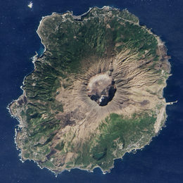
1048:
1000:
953:
879:
809:
739:
669:
599:
529:
524:
521:
518:
515:
512:
509:
506:
503:
500:
497:
494:
491:
488:
485:
465:humid subtropical climate
335:
250:
238:
159:
56:
47:
1898:Holocene stratovolcanoes
1868:Stratovolcanoes of Japan
1834:Global Volcanism Program
1749:"三宅村営バス時刻表 (平成30年5月1日より"
1639:
1612:
1489:
1463:Nussbaum, Louis-Frédéric
1420:List of islands of Japan
1839:Smithsonian Institution
1251:, which is operated by
1375:
1239:
1231:
1159:BirdLife International
311:
234:Additional information
139:Highest elevation
1613:観測史上1~10位の値(年間を通じての値)
1373:
1237:
1230:Flag of Miyake, Tokyo
1229:
1175:Ijima's leaf-warblers
1163:Japanese wood pigeons
398:west south-west of it
309:
1261:Hamamatsuchō Station
530:Record high °C (°F)
187:Miyake Subprefecture
1666:"Miyakejima island"
1598:2009EGUGA..11.5839L
1529:on 22 February 2005
1495:Japanese Literature
1474:Japan Encyclopedia,
1270:Salvia Maru (さるびあ丸)
1249:Tachibana Maru (橘丸)
1155:Important Bird Area
810:Record low °C (°F)
670:Daily mean °C (°F)
392:Map of Miyake-jima,
93: /
34:
1883:Volcanoes of Tokyo
1670:BirdLife Data Zone
1640:気象庁 / 平年値(年・月ごとの値)
1376:
1357:Miyakejima Helipad
1279:Miyakejima Airport
1240:
1232:
1195:Tokyo Metropolitan
1167:Japanese murrelets
463:Miyake-jima has a
410:View from Airplane
312:
254:, "Miyake Island")
147:Highest point
97:34.079°N 139.529°E
1737:on 26 April 2008.
1696:The Asahi Shimbun
1364:
1363:
1140:
1132:
1131:
1103:
1102:
1003:relative humidity
456:
455:
242:
241:
16:(Redirected from
1905:
1893:Seabird colonies
1878:Islands of Tokyo
1873:Active volcanoes
1849:
1847:
1845:
1817:
1815:
1806:
1768:
1767:
1765:
1763:
1756:miyakejima.gr.jp
1753:
1745:
1739:
1738:
1733:. Archived from
1727:
1721:
1720:
1713:
1707:
1706:
1704:
1702:
1688:
1682:
1681:
1679:
1677:
1662:
1656:
1655:
1653:
1651:
1635:
1629:
1628:
1626:
1624:
1608:
1602:
1601:
1581:
1575:
1574:
1572:
1570:
1564:
1553:
1545:
1539:
1538:
1536:
1534:
1525:. Archived from
1519:
1513:
1512:
1510:
1483:
1477:
1460:
1409:
1404:
1403:
1395:
1390:
1389:
1388:
1354:
1342:
1330:
1320:
1319:
1215:
1213:
1207:
1206:
1134:
1114:
1113:
1106:
957:
478:
443:
431:
419:
407:
389:
379:
378:
346:
344:
338:
337:
319:The island is a
255:
253:
252:
108:
107:
105:
104:
103:
98:
94:
91:
90:
89:
86:
52:
35:
21:
1913:
1912:
1908:
1907:
1906:
1904:
1903:
1902:
1853:
1852:
1843:
1841:
1827:
1813:
1809:
1804:
1792:
1772:
1771:
1761:
1759:
1751:
1747:
1746:
1742:
1729:
1728:
1724:
1715:
1714:
1710:
1700:
1698:
1690:
1689:
1685:
1675:
1673:
1664:
1663:
1659:
1649:
1647:
1641:
1637:
1636:
1632:
1622:
1620:
1614:
1610:
1609:
1605:
1583:
1582:
1578:
1568:
1566:
1565:on 26 June 2011
1562:
1551:
1547:
1546:
1542:
1532:
1530:
1521:
1520:
1516:
1497:(in Japanese).
1491:
1485:
1484:
1480:
1461:
1457:
1452:
1405:
1398:
1391:
1386:
1384:
1381:
1358:
1355:
1346:
1343:
1334:
1331:
1305:, Miyake-jima,
1245:
1201:
1191:
1146:
1144:Flora and fauna
1128:
1115:
1111:
1104:
955:
948:
943:
938:
933:
928:
923:
918:
913:
908:
903:
898:
893:
888:
874:
869:
864:
859:
854:
849:
844:
839:
834:
829:
824:
819:
814:
804:
799:
794:
789:
784:
779:
774:
769:
764:
759:
754:
749:
744:
734:
729:
724:
719:
714:
709:
704:
699:
694:
689:
684:
679:
674:
664:
659:
654:
649:
644:
639:
634:
629:
624:
619:
614:
609:
604:
594:
589:
584:
579:
574:
569:
564:
559:
554:
549:
544:
539:
534:
461:
450:
444:
435:
432:
423:
420:
411:
408:
399:
393:
390:
332:
317:
286:
262:Izu archipelago
247:
164:
102:34.079; 139.529
101:
99:
95:
92:
87:
84:
82:
80:
79:
43:
42:
30:
23:
22:
15:
12:
11:
5:
1911:
1909:
1901:
1900:
1895:
1890:
1885:
1880:
1875:
1870:
1865:
1855:
1854:
1851:
1850:
1825:
1819:
1807:
1798:
1791:
1790:External links
1788:
1787:
1786:
1770:
1769:
1740:
1722:
1708:
1683:
1657:
1630:
1603:
1576:
1540:
1514:
1478:
1454:
1453:
1451:
1448:
1447:
1446:
1438:
1432:
1427:
1422:
1417:
1411:
1410:
1407:Islands portal
1396:
1380:
1377:
1362:
1361:
1360:
1359:
1356:
1349:
1347:
1344:
1337:
1335:
1332:
1325:
1283:Haneda Airport
1265:Tachibana Maru
1257:Takeshiba Pier
1244:
1241:
1199:Miyake Village
1190:
1189:Administration
1187:
1145:
1142:
1137:raw graph data
1130:
1129:
1118:
1116:
1109:
1101:
1100:
1093:
1092:
1089:
1086:
1083:
1080:
1077:
1074:
1071:
1068:
1065:
1062:
1059:
1056:
1053:
1051:sunshine hours
1046:
1045:
1042:
1039:
1036:
1033:
1030:
1027:
1024:
1021:
1018:
1015:
1012:
1009:
1006:
998:
997:
994:
991:
988:
985:
982:
979:
976:
973:
970:
967:
964:
961:
958:
951:
950:
945:
940:
935:
930:
925:
920:
915:
910:
905:
900:
895:
890:
885:
877:
876:
871:
866:
861:
856:
851:
846:
841:
836:
831:
826:
821:
816:
811:
807:
806:
801:
796:
791:
786:
781:
776:
771:
766:
761:
756:
751:
746:
741:
737:
736:
731:
726:
721:
716:
711:
706:
701:
696:
691:
686:
681:
676:
671:
667:
666:
661:
656:
651:
646:
641:
636:
631:
626:
621:
616:
611:
606:
601:
597:
596:
591:
586:
581:
576:
571:
566:
561:
556:
551:
546:
541:
536:
531:
527:
526:
523:
520:
517:
514:
511:
508:
505:
502:
499:
496:
493:
490:
487:
483:
482:
476:
460:
457:
454:
453:
452:
451:
445:
438:
436:
433:
426:
424:
421:
414:
412:
409:
402:
400:
391:
384:
361:sulfur dioxide
316:
313:
285:
282:
266:Philippine Sea
260:island in the
240:
239:
236:
235:
231:
230:
227:
223:
222:
219:
215:
214:
211:
207:
206:
202:
201:
196:
190:
189:
184:
178:
177:
172:
166:
165:
160:
157:
156:
155:Administration
152:
151:
148:
144:
143:
140:
136:
135:
132:
128:
127:
124:
120:
119:
114:
110:
109:
77:
73:
72:
70:Philippine Sea
67:
63:
62:
58:
57:
54:
53:
45:
44:
40:
38:
28:
24:
14:
13:
10:
9:
6:
4:
3:
2:
1910:
1899:
1896:
1894:
1891:
1889:
1886:
1884:
1881:
1879:
1876:
1874:
1871:
1869:
1866:
1864:
1861:
1860:
1858:
1840:
1836:
1835:
1830:
1826:
1823:
1820:
1812:
1808:
1805:(in Japanese)
1802:
1799:
1797:
1794:
1793:
1789:
1785:
1784:4-8071-0004-1
1781:
1777:
1774:
1773:
1758:(in Japanese)
1757:
1750:
1744:
1741:
1736:
1732:
1726:
1723:
1718:
1712:
1709:
1697:
1693:
1687:
1684:
1671:
1667:
1661:
1658:
1646:
1642:
1634:
1631:
1619:
1615:
1607:
1604:
1599:
1595:
1591:
1587:
1580:
1577:
1561:
1557:
1550:
1544:
1541:
1528:
1524:
1518:
1515:
1509:
1504:
1500:
1496:
1492:
1482:
1479:
1475:
1472:
1470:
1464:
1459:
1456:
1449:
1444:
1443:
1439:
1436:
1433:
1431:
1428:
1426:
1423:
1421:
1418:
1416:
1413:
1412:
1408:
1402:
1397:
1394:
1383:
1378:
1372:
1368:
1353:
1348:
1341:
1336:
1329:
1324:
1322:
1321:
1318:
1316:
1312:
1308:
1304:
1300:
1296:
1292:
1288:
1287:Chofu Airport
1284:
1280:
1275:
1274:
1271:
1266:
1262:
1258:
1254:
1250:
1242:
1236:
1228:
1224:
1221:
1219:
1212:
1200:
1196:
1188:
1186:
1184:
1180:
1176:
1172:
1168:
1164:
1160:
1156:
1152:
1143:
1141:
1138:
1126:
1125:MediaWiki.org
1122:
1117:
1108:
1107:
1099:
1094:
1090:
1087:
1084:
1081:
1078:
1075:
1072:
1069:
1066:
1063:
1060:
1057:
1054:
1052:
1049:Mean monthly
1047:
1043:
1040:
1037:
1034:
1031:
1028:
1025:
1022:
1019:
1016:
1013:
1010:
1007:
1004:
999:
995:
992:
989:
986:
983:
980:
977:
974:
971:
968:
965:
962:
959:
952:
946:
941:
936:
931:
926:
921:
916:
911:
906:
901:
896:
891:
886:
883:
882:precipitation
878:
872:
867:
862:
857:
852:
847:
842:
837:
832:
827:
822:
817:
812:
808:
802:
797:
792:
787:
782:
777:
772:
767:
762:
757:
752:
747:
742:
738:
732:
727:
722:
717:
712:
707:
702:
697:
692:
687:
682:
677:
672:
668:
662:
657:
652:
647:
642:
637:
632:
627:
622:
617:
612:
607:
602:
598:
592:
587:
582:
577:
572:
567:
562:
557:
552:
547:
542:
537:
532:
528:
484:
479:
475:
473:
470:
466:
458:
448:
442:
437:
430:
425:
418:
413:
406:
401:
397:
388:
383:
381:
380:
377:
375:
371:
366:
362:
356:
354:
350:
343:
330:
326:
322:
321:stratovolcano
314:
308:
304:
302:
298:
294:
292:
283:
281:
279:
275:
271:
267:
263:
259:
246:
237:
232:
228:
226:Ethnic groups
224:
220:
216:
212:
208:
203:
200:
197:
195:
191:
188:
185:
183:
182:Subprefecture
179:
176:
173:
171:
167:
163:
158:
153:
149:
145:
141:
137:
133:
129:
125:
121:
118:
115:
111:
106:
78:
74:
71:
68:
64:
59:
55:
51:
46:
39:Native name:
36:
27:
19:
18:Miyake Island
1842:. Retrieved
1832:
1829:"Miyakejima"
1775:
1760:. Retrieved
1755:
1743:
1735:the original
1725:
1711:
1699:. Retrieved
1695:
1686:
1674:. Retrieved
1669:
1660:
1648:. Retrieved
1633:
1621:. Retrieved
1606:
1585:
1579:
1567:. Retrieved
1560:the original
1543:
1531:. Retrieved
1527:the original
1517:
1498:
1494:
1481:
1473:
1468:
1458:
1440:
1393:Tokyo portal
1365:
1311:Hachijō-jima
1276:
1273:
1269:
1264:
1248:
1246:
1222:
1192:
1182:
1179:Izu thrushes
1147:
1135:See or edit
1133:
884:mm (inches)
471:
462:
357:
353:Meiji period
318:
296:
290:
287:
244:
243:
218:Pop. density
213:2,460 (2019)
205:Demographics
161:
26:
1863:Izu Islands
1822:Miyake Jima
1650:23 February
1623:23 February
1430:Devil's Sea
1425:Izu Islands
1307:Mikura-jima
1301:and fly to
1268:ship named
1253:Tōkai Kisen
1218:Ōnoharajima
1211:Miyake-mura
1151:Mikura-jima
1121:Phabricator
396:Ōnoharajima
349:Nara period
329:Pleistocene
245:Miyake-jima
117:Izu Islands
113:Archipelago
100: /
88:139°31′44″E
76:Coordinates
1857:Categories
1801:Miyakejima
1676:30 January
1569:10 January
1533:3 February
1465:. (2005).
1450:References
1435:Jack Moyer
1299:Izu Ōshima
1291:Izu Ōshima
956:(≥ 1.0 mm)
210:Population
170:Prefecture
85:34°04′44″N
33:Miyakejima
1469:Izu Shotō
1315:Aogashima
1295:Aogashima
1157:(IBA) by
949:(119.08)
365:gas masks
342:Oyama-san
315:Geography
284:Etymology
131:Coastline
61:Geography
1379:See also
1183:akakokko
1096:Source:
1091:1,693.3
1001:Average
934:(16.49)
929:(13.03)
914:(13.77)
899:(10.85)
880:Average
325:granitic
301:Miyajima
291:Miyakeki
258:volcanic
229:Japanese
66:Location
1844:24 June
1762:30 June
1701:30 June
1594:Bibcode
1476:p. 412.
1442:Two Car
1303:Toshima
1259:, near
1123:and on
947:3,024.7
944:(6.74)
939:(9.22)
924:(8.13)
919:(9.46)
909:(9.58)
904:(9.03)
894:(6.73)
889:(5.94)
875:(29.5)
870:(33.6)
865:(38.7)
860:(48.0)
855:(57.4)
850:(64.8)
845:(58.6)
840:(53.8)
835:(45.3)
830:(37.0)
825:(31.6)
820:(29.5)
815:(29.8)
805:(59.5)
800:(49.5)
795:(57.4)
790:(65.1)
785:(72.0)
780:(75.7)
775:(73.8)
770:(67.1)
765:(61.2)
760:(54.9)
755:(48.6)
750:(44.4)
745:(44.8)
735:(64.3)
730:(54.5)
725:(62.2)
720:(69.4)
715:(76.1)
710:(79.9)
705:(77.5)
700:(71.2)
695:(66.6)
690:(60.4)
685:(54.1)
680:(50.0)
675:(49.8)
665:(68.7)
660:(58.3)
655:(66.2)
650:(73.2)
645:(80.1)
640:(84.4)
635:(82.0)
630:(75.6)
625:(71.4)
620:(65.5)
615:(59.0)
610:(54.3)
605:(53.8)
595:(91.6)
590:(74.8)
585:(78.3)
580:(84.9)
575:(90.1)
570:(91.0)
565:(91.6)
560:(88.0)
555:(82.6)
550:(76.8)
545:(72.5)
540:(71.2)
535:(68.2)
459:Climate
323:with a
297:Mashima
264:in the
194:Village
1782:
1243:Access
1088:108.7
1085:107.2
1082:103.9
1079:136.0
1076:221.9
1073:182.8
1070:126.8
1067:181.8
1064:166.7
1061:133.5
1058:117.9
1055:114.8
996:138.9
486:Month
199:Miyake
1814:(PDF)
1752:(PDF)
1563:(PDF)
1552:(PDF)
993:10.7
990:12.0
987:13.8
984:13.5
978:10.2
975:13.6
972:11.3
969:11.5
966:14.1
963:10.1
942:171.1
937:234.2
932:418.9
927:330.9
922:206.6
917:240.2
912:349.7
907:243.3
902:229.3
897:275.6
892:170.9
887:150.9
525:Year
447:Torii
394:with
293:(三宅記)
274:Japan
270:Tokyo
256:is a
175:Tokyo
162:Japan
150:Oyama
1846:2021
1780:ISBN
1764:2023
1703:2023
1678:2021
1652:2022
1625:2022
1571:2011
1535:2005
1313:and
1297:and
1281:and
1177:and
1005:(%)
981:8.9
960:9.2
873:−1.4
853:14.1
848:18.2
843:14.8
838:12.1
823:−0.2
818:−1.4
813:−1.2
803:15.3
793:14.1
788:18.4
783:22.2
778:24.3
773:23.2
768:19.5
763:16.2
758:12.7
733:18.0
728:12.5
723:16.8
718:20.8
713:24.5
708:26.6
703:25.3
698:21.8
693:19.2
688:15.8
683:12.3
678:10.0
663:20.4
658:14.6
653:19.0
648:22.9
643:26.7
638:29.1
633:27.8
628:24.2
623:21.9
618:18.6
613:15.0
608:12.4
603:12.1
593:33.1
588:23.8
583:25.7
578:29.4
573:32.3
568:32.8
563:33.1
558:31.1
553:28.1
548:24.9
543:22.5
538:21.8
533:20.1
522:Dec
519:Nov
516:Oct
513:Sep
510:Aug
507:Jul
504:Jun
501:May
498:Apr
495:Mar
492:Feb
489:Jan
123:Area
1645:JMA
1618:JMA
1503:doi
1205:三宅村
1185:).
1044:76
1041:67
1038:72
1035:78
1032:83
1029:86
1026:87
1023:86
1020:79
1017:73
1014:70
1011:66
1008:65
868:0.9
863:3.7
858:8.9
833:7.4
828:2.8
798:9.7
753:9.2
748:6.9
743:7.1
673:9.9
472:Cfa
251:三宅島
41:三宅島
1859::
1837:.
1831:.
1754:.
1694:.
1668:.
1643:.
1616:.
1588:.
1554:.
1499:57
1471:,"
1317:.
1309:,
1208:,
1173:,
1169:,
1165:,
376:.
339:,
336:雄山
280:.
272:,
1848:.
1816:.
1766:.
1719:.
1705:.
1680:.
1654:.
1627:.
1600:.
1596::
1573:.
1537:.
1505::
1467:"
1214:)
1202:(
1181:(
1139:.
1127:.
467:(
345:)
333:(
248:(
20:)
Text is available under the Creative Commons Attribution-ShareAlike License. Additional terms may apply.