308:
46:
940:
251:
114:
53:
889:
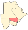
179:, the capital of Botswana. The population was 3,512 in 2001 census and 14,655 at the 2011 census. It's now part of Gaborone agglomeration home to 421,907 inhabitants at the 2011 census.
540:
981:
240:
533:
77:
1010:
526:
196:
974:
233:
45:
1005:
967:
550:
197:"Distribution of population by sex by villages and their associated localities: 2001 population and housing census"
1000:
226:
901:
568:
124:
218:
811:
402:
482:
337:
518:
387:
153:
951:
507:
462:
377:
307:
254:
168:
129:
631:
867:
847:
796:
791:
612:
200:
994:
758:
618:
427:
939:
606:
422:
392:
367:
352:
327:
287:
594:
497:
492:
332:
250:
113:
857:
786:
675:
600:
372:
322:
292:
282:
916:
903:
92:
79:
862:
852:
827:
801:
733:
644:
457:
432:
382:
947:
842:
743:
700:
670:
660:
588:
554:
502:
447:
417:
412:
397:
357:
347:
258:
176:
172:
117:
837:
816:
770:
695:
690:
685:
665:
655:
638:
472:
452:
437:
407:
297:
142:
32:
806:
776:
753:
748:
727:
716:
711:
680:
624:
477:
467:
342:
277:
272:
872:
832:
738:
487:
362:
781:
522:
222:
955:
315:
265:
151:
140:
135:
123:
108:
23:
175:. The village is located around 15 km from
975:
534:
234:
8:
982:
968:
577:
541:
527:
519:
241:
227:
219:
20:
188:
134:
107:
72:
38:
150:
139:
122:
18:Village in Kweneng District, Botswana
7:
936:
934:
954:. You can help Knowledge (XXG) by
14:
938:
306:
249:
112:
51:
44:
52:
1:
1027:
933:
886:
575:
562:
304:
73:
39:
30:
1011:Botswana geography stubs
825:
767:
709:
653:
950:location article is a
917:24.56694°S 25.87333°E
567:indicate capitals of
93:24.56694°S 25.87333°E
1006:Villages in Botswana
259:Republic of Botswana
167:is a village in the
65:Location in Botswana
922:-24.56694; 25.87333
913: /
203:on 24 November 2007
98:-24.56694; 25.87333
89: /
581:
963:
962:
896:
895:
881:
880:
516:
515:
162:
161:
1018:
1001:Kweneng District
984:
977:
970:
942:
935:
928:
927:
925:
924:
923:
918:
914:
911:
910:
909:
906:
578:
543:
536:
529:
520:
310:
255:Kweneng District
253:
243:
236:
229:
220:
213:
212:
210:
208:
199:. Archived from
193:
169:Kweneng District
130:Kweneng District
116:
104:
103:
101:
100:
99:
94:
90:
87:
86:
85:
82:
55:
54:
48:
21:
1026:
1025:
1021:
1020:
1019:
1017:
1016:
1015:
991:
990:
989:
988:
931:
921:
919:
915:
912:
907:
904:
902:
900:
899:
897:
892:
888:Retrieved from
882:
877:
821:
763:
705:
649:
571:
558:
547:
517:
512:
311:
302:
261:
247:
217:
216:
206:
204:
195:
194:
190:
185:
97:
95:
91:
88:
83:
80:
78:
76:
75:
69:
68:
67:
66:
63:
62:
61:
60:
56:
35:
26:
19:
12:
11:
5:
1024:
1022:
1014:
1013:
1008:
1003:
993:
992:
987:
986:
979:
972:
964:
961:
960:
943:
894:
893:
887:
884:
883:
879:
878:
876:
875:
870:
865:
860:
855:
850:
845:
840:
835:
830:
824:
822:
820:
819:
814:
809:
804:
799:
794:
792:Molapowabojang
789:
784:
779:
774:
766:
764:
762:
761:
756:
751:
746:
741:
736:
731:
724:
719:
714:
708:
706:
704:
703:
698:
693:
688:
683:
678:
673:
668:
663:
658:
652:
650:
648:
647:
642:
635:
628:
621:
616:
609:
604:
597:
592:
584:
582:
576:
573:
572:
563:
560:
559:
548:
546:
545:
538:
531:
523:
514:
513:
511:
510:
505:
500:
495:
490:
485:
480:
475:
470:
465:
460:
455:
450:
445:
440:
435:
430:
425:
420:
415:
410:
405:
400:
395:
390:
385:
380:
375:
370:
365:
360:
355:
350:
345:
340:
335:
330:
325:
319:
317:
316:Rural villages
313:
312:
305:
303:
301:
300:
295:
290:
285:
280:
275:
269:
267:
266:Urban villages
263:
262:
248:
246:
245:
238:
231:
223:
215:
214:
187:
186:
184:
181:
160:
159:
156:
149:
148:
145:
138:
137:
133:
132:
127:
121:
120:
110:
106:
105:
71:
70:
64:
58:
57:
50:
49:
43:
42:
41:
40:
37:
36:
31:
28:
27:
24:
17:
13:
10:
9:
6:
4:
3:
2:
1023:
1012:
1009:
1007:
1004:
1002:
999:
998:
996:
985:
980:
978:
973:
971:
966:
965:
959:
957:
953:
949:
944:
941:
937:
932:
929:
926:
891:
885:
874:
871:
869:
866:
864:
861:
859:
856:
854:
851:
849:
846:
844:
841:
839:
836:
834:
831:
829:
826:
823:
818:
815:
813:
810:
808:
805:
803:
800:
798:
795:
793:
790:
788:
785:
783:
780:
778:
775:
773:
772:
768:
765:
760:
759:Metsimotlhaba
757:
755:
752:
750:
747:
745:
742:
740:
737:
735:
732:
730:
729:
725:
723:
720:
718:
715:
713:
710:
707:
702:
699:
697:
694:
692:
689:
687:
684:
682:
679:
677:
674:
672:
669:
667:
664:
662:
659:
657:
654:
651:
646:
643:
641:
640:
636:
634:
633:
629:
627:
626:
622:
620:
619:Selebi-Phikwe
617:
615:
614:
610:
608:
605:
603:
602:
598:
596:
593:
591:
590:
586:
585:
583:
580:
579:
574:
570:
566:
561:
557:by population
556:
552:
544:
539:
537:
532:
530:
525:
524:
521:
509:
506:
504:
501:
499:
496:
494:
491:
489:
486:
484:
481:
479:
476:
474:
471:
469:
466:
464:
461:
459:
456:
454:
451:
449:
446:
444:
441:
439:
436:
434:
431:
429:
428:Metsimotlhabe
426:
424:
421:
419:
416:
414:
411:
409:
406:
404:
403:Losilakgokong
401:
399:
396:
394:
391:
389:
386:
384:
381:
379:
376:
374:
371:
369:
366:
364:
361:
359:
356:
354:
351:
349:
346:
344:
341:
339:
336:
334:
331:
329:
326:
324:
321:
320:
318:
314:
309:
299:
296:
294:
291:
289:
286:
284:
281:
279:
276:
274:
271:
270:
268:
264:
260:
256:
252:
244:
239:
237:
232:
230:
225:
224:
221:
202:
198:
192:
189:
182:
180:
178:
174:
170:
166:
157:
155:
152: •
146:
144:
141: •
131:
128:
126:
119:
115:
111:
102:
74:Coordinates:
47:
34:
29:
22:
16:
956:expanding it
945:
930:
898:
769:
726:
721:
637:
630:
623:
611:
607:Mogoditshane
599:
587:
564:
442:
423:Mantshwabisi
393:Lentsweletau
368:Khudumelapye
353:Hatsalatladi
328:Botlhapatlou
288:Mogoditshane
205:. Retrieved
201:the original
191:
164:
163:
15:
920: /
890:2011 Census
595:Francistown
549:50 largest
498:Takatokwane
493:Sorilatholo
333:Ditshegwane
207:10 February
96: /
995:Categories
908:25°52′24″E
858:Lotlhakane
787:Letlhakeng
676:Letlhakane
601:Molepolole
483:Shadishadi
373:Kotolaname
338:Ditshukudu
323:Boatlaname
293:Molepolole
283:Letlhakeng
183:References
136:Population
84:25°52′24″E
905:24°34′1″S
863:Tsienyane
853:Kumakwane
828:Maitengwe
812:Good Hope
802:Mmankgodi
734:Mmadinare
645:Mahalapye
569:districts
458:Moshaweng
433:Mmankgodi
383:Kumakwane
81:24°34′1″S
948:Botswana
843:Borolong
744:Shoshong
701:Bobonong
671:Ramotswa
661:Tlokweng
589:Gaborone
555:Botswana
503:Tsetseng
448:Mogonono
418:Malwelwe
413:Mahetlwe
398:Lephephe
358:Kaudwane
348:Gakgatla
177:Gaborone
173:Botswana
158:Gaborone
125:District
118:Botswana
838:Masunga
817:Shakawe
771:Tsabong
722:Mmopane
696:Jwaneng
691:Thamaga
686:Moshupa
666:Lobatse
656:Palapye
639:Mochudi
565:Italics
508:Tswaane
473:Salajwe
463:Motokwe
453:Monwane
443:Mmopane
438:Mmanoko
408:Maboane
388:Kweneng
298:Thamaga
257:of the
165:Mmopane
143:Village
109:Country
59:Mmopane
33:Village
25:Mmopane
807:Lerala
777:Gumare
754:Kasane
749:Kopong
728:Ghanzi
717:Gabane
712:Tutume
681:Tonota
625:Serowe
551:cities
478:Sesung
468:Ngware
378:Kubung
343:Dutlwe
278:Kopong
273:Gabane
147:14,655
946:This
873:Gweta
833:Bokaa
739:Orapa
632:Kanye
488:Sojwe
363:Kgope
154:Metro
952:stub
868:Nata
848:Oodi
797:Tati
782:Otse
613:Maun
209:2008
553:of
171:of
997::
983:e
976:t
969:v
958:.
542:e
535:t
528:v
242:e
235:t
228:v
211:.
Text is available under the Creative Commons Attribution-ShareAlike License. Additional terms may apply.
↑