168:
52:
378:
iced sweet dessert in
Thailand for over 100 years. At the end of 2023, CPB renovated the shophouses to be more modern. These restaurants had to move to new locations in nearby areas.
328:
combined with the high density of houses. Since then, the government in general banned the construction of wooden dwellings. The surviving
Phlapphla Chai 2 Police Station site on
304:(Saphan Lek) to here also serves as an administrative boundary between Pom Prap Sattru Phai (left side) with Samphanthwawong (right side) districts, and also has
541:
372:(CPB), and is well known as the centre of foods and desserts with famous ancient restaurants, like Singapore, which has been the first to sell
465:
324:
In 1898, a fire occurred in this area, spreading rapidly across the neighborhood because of its contemporary design of wooden framing with
297:(Rama IV)'s reign, Mo Mi was only a three-way junction consisting of Charoen Krung and Thanon Trong roads which later became Rama IV road.
546:
531:
264:
The boundaries of Mo Mi are considered to be where Rama IV and
Mittraphan roads originate, and where Song Sawat road terminates.
536:
335:"Mo Mi" was named after Mo Mi or Boonmi Kasemsuvan, a pharmacist who specialized in herbal and medical chemistry, especially
503:[Ending the legend of the old locations of 2 famous Charoen Krung shops Kan Kee Nam Tao Thong - Singapore Cendol].
86:
358:
351:
93:
219:
481:
293:), meaning "Three-Way Junction of Charoen Krung." The original name of Mo Mi came from the fact that during
321:(ตำบล; sub-district) was called "Tambon Sam Yaek" in the province of Phra Nakhon (known today as Bangkok).
199:
369:
301:
172:
156:
357:
One interesting thing about this intersection is the location of Tai Sia Huk Chou Shrine, a small old
211:
71:
159:
350:
stores, but at present there is only one left on Rama IV road. It was also home to many leading
461:
258:
167:
51:
500:
336:
305:
329:
325:
223:
75:
525:
289:
276:
254:
230:
194:
182:
137:
294:
246:
242:
234:
132:
17:
400:
238:
395:
362:
434:
108:
95:
215:
347:
250:
207:
203:
501:"ปิดตำนานทำเลเก่า 2 ร้านดังเจริญกรุง คั้นกี่น้ำเต้าทอง-ลอดช่องสิงคโปร์"
343:
79:
415:
374:
317:
312:
332:
road was known as Sam Yaek Police
Station at the time of the fire.
166:
342:
The area around Mo Mi in the past was well-known as a centre of
171:
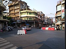
View of Mo Mi from
Charoen Krung road toward Canton Shrine and
418:[History of Phlapphlachai 2 Police Station].
368:
At present the land plot around Mo Mi belongs to the
300:
Charoen Krung Road that runs through this area from
460:] (in Thai). Bangkok: Museum Siam. p. 43.
229:This intersection consists of the following roads:
198:) is a large intersection located in the centre of
151:
146:
124:
85:
65:
35:
361:on Rama IV road, the only one shrine dedicated to
267:Mo Mi, formerly and still colloquially known as
8:
398:[Fan Pan Tae 2003 : Bangkok].
249:), Song Sawat (from Wat Samphanthawong and
339:. His dispensary was located in the area.
50:
41:
32:
280:), which means "Three-Way Junction," and
396:"แฟนพันธุ์แท้ 2003 : กรุงเทพมหานคร"
387:
458:A tale of MRT Blue Line two tracksides
27:Road intersection in Bangkok, Thailand
416:"ประวัติสถานีตำรวจนครบาลพลับพลาไชย ๒"
288:
275:
193:
7:
499:Samniangjam, Chatkla (2023-11-28).
452:Suteerattanapirom, Kannika (2018).
437:[Mo Chit, Mo Mi, Mo Leng].
354:, currently closed to the business
454:เรื่องเล่าสองข้างราง MRT สีน้ำเงิน
25:
439:LEK-PRAPAI VIRIYAHPANT FOUNDATION
311:Under the past administration of
290:[sǎːmjɛ̂ːkt͡ɕā.rɤ̄ːnkrūŋ]
433:Sujchaya, Sudara (2016-06-08).
420:Phlapphlachai 2 Police Station
1:
542:Pom Prap Sattru Phai district
315:Samphanthawong, this area or
257:road) and Mittraphan (toward
563:
109:13.7404306°N 100.5122306°E
547:Road junctions in Bangkok
532:Neighbourhoods of Bangkok
482:"Tai Sia Huk Chou Shrine"
186:
70:
61:
56:Seen from Song Sawat road
49:
42:
40:
537:Samphanthawong district
435:"หมอชิต หมอมี หมอเหล็ง"
365:in the Chinatown area.
114:13.7404306; 100.5122306
404:(in Thai). 2014-06-02.
282:Sam Yaek Charoen Krung
175:
142:Song Sawat (southwest)
130:Mittraphan (northeast)
370:Crown Property Bureau
302:Damrong Sathit bridge
173:Wat Mangkon Kamalawat
170:
212:Pom Prap Sattru Phai
202:quarter lies on the
72:Pom Prap Sattru Phai
277:[sǎːmjɛ̂ːk]
200:Bangkok's Chinatown
105: /
284:(สามแยกเจริญกรุง,
176:
18:Mo Mi Intersection
467:978-616-8162-03-3
195:[mɔ̌ːmīː]
165:
164:
140:(south–northwest)
16:(Redirected from
554:
516:
515:
513:
512:
496:
490:
489:
478:
472:
471:
449:
443:
442:
430:
424:
423:
412:
406:
405:
392:
292:
287:
279:
274:
259:July 22nd Circle
197:
192:
188:
120:
119:
117:
116:
115:
110:
106:
103:
102:
101:
98:
54:
45:
44:
33:
21:
562:
561:
557:
556:
555:
553:
552:
551:
522:
521:
520:
519:
510:
508:
498:
497:
493:
486:Tourist Bangkok
480:
479:
475:
468:
451:
450:
446:
432:
431:
427:
414:
413:
409:
394:
393:
389:
384:
306:one-way traffic
285:
272:
190:
141:
136:
131:
126:
113:
111:
107:
104:
99:
96:
94:
92:
91:
57:
31:
28:
23:
22:
15:
12:
11:
5:
560:
558:
550:
549:
544:
539:
534:
524:
523:
518:
517:
491:
473:
466:
444:
425:
407:
386:
385:
383:
380:
352:movie theaters
330:Phlapphla Chai
326:thatched roofs
224:Samphanthawong
220:Samphanthawong
163:
162:
153:
149:
148:
144:
143:
128:
122:
121:
100:100°30′44.03″E
89:
83:
82:
76:Samphanthawong
68:
67:
63:
62:
59:
58:
55:
47:
46:
38:
37:
29:
26:
24:
14:
13:
10:
9:
6:
4:
3:
2:
559:
548:
545:
543:
540:
538:
535:
533:
530:
529:
527:
506:
502:
495:
492:
487:
483:
477:
474:
469:
463:
459:
455:
448:
445:
440:
436:
429:
426:
421:
417:
411:
408:
403:
402:
397:
391:
388:
381:
379:
377:
376:
371:
366:
364:
360:
355:
353:
349:
345:
340:
338:
333:
331:
327:
322:
320:
319:
314:
309:
307:
303:
298:
296:
291:
283:
278:
270:
265:
262:
260:
256:
252:
248:
244:
240:
236:
232:
231:Charoen Krung
227:
225:
221:
217:
214:district and
213:
209:
205:
201:
196:
184:
180:
174:
169:
161:
158:
154:
150:
145:
139:
138:Charoen Krung
134:
129:
123:
118:
97:13°44′25.55″N
90:
88:
84:
81:
77:
73:
69:
64:
60:
53:
48:
39:
34:
30:Road junction
19:
509:. Retrieved
505:The Standard
504:
494:
485:
476:
457:
453:
447:
438:
428:
419:
410:
399:
390:
373:
367:
356:
341:
334:
323:
316:
310:
299:
295:King Mongkut
281:
268:
266:
263:
247:Hua Lamphong
235:Odeon Circle
228:
178:
177:
160:intersection
147:Construction
401:Fan Pan Tae
239:Wat Traimit
135:(southeast)
112: /
87:Coordinates
78:districts,
526:Categories
511:2024-04-09
441:(in Thai).
422:(in Thai).
382:References
363:Sun Wukong
359:joss house
286:pronounced
273:pronounced
226:district.
191:pronounced
507:(in Thai)
308:as well.
271:(สามแยก,
216:Talat Noi
155:Five-way
348:duckling
269:Sam Yaek
255:Song Wat
251:Sampheng
245:(toward
233:(toward
208:Pom Prap
206:between
204:tripoint
157:at-grade
127:junction
125:Roads at
66:Location
243:Rama IV
133:Rama IV
80:Bangkok
464:
375:cendol
318:tambon
313:Amphoe
253:, via
456:[
344:chick
337:snuff
218:with
187:หมอมี
179:Mo Mi
43:หมอมี
36:Mo Mi
462:ISBN
346:and
261:).
237:and
183:Thai
152:Type
74:and
241:),
222:of
210:of
528::
484:.
189:,
185::
514:.
488:.
470:.
181:(
20:)
Text is available under the Creative Commons Attribution-ShareAlike License. Additional terms may apply.