177:
227:
184:
78:
220:
31:
344:
The summit was often considered to be the highest summit in the
Berwyns (and therefore the county top of Denbighshire as well as Montgomeryshire) until the Cadair Berwyn North Top, then known as Cadair Berwyn was found to be of the same height. Later on the OS discovered a new top in between the two,
423:
484:
273:
494:
176:
499:
443:
Nuttall, John & Anne (1999). The
Mountains of England & Wales - Volume 1: Wales (2nd edition ed.). Milnthorpe, Cumbria: Cicerone.
109:
448:
219:
267:
102:
479:
323:
66:
56:
77:
86:
489:
444:
397:
330:
286:
281:
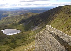
369:
338:
306:
253:
157:
95:
473:
311:
91:
71:
464:
334:
319:
260:
196:
345:
which was 5m higher at 832m. This top, now known as Cadair Berwyn, is listed as
124:
111:
310:) with a height of 826.7 metres (2,712 ft) is a subsidiary summit of
352:
The summit has a cairn, and overlooks Llyn
Lluncaws in the southern Cwm.
465:
www.geograph.co.uk : photos of Cadair Berwyn and surrounding area
30:
46:
341:. It is the highest point (historic county top) of Montgomeryshire.
315:
204:
200:
329:
The summit lies at the triple historic county boundary point of
280:
266:
252:
163:
153:
145:
140:
101:
85:
65:
55:
45:
40:
23:
8:
76:
20:
318:. It is the third highest summit in the
361:
392:
390:
305:
7:
485:Mountains and hills of Denbighshire
14:
226:
183:
495:Highest points of Welsh counties
225:
218:
182:
175:
29:
16:Mountain in Denbighshire, Wales
370:"Topographic map of Moel Sych"
1:
500:Mountains and hills of Powys
51:826.7 m (2,712 ft)
35:Moel Sych and Llyn Lluncaws
516:
168:
61:33.9 m (111 ft)
28:
322:after Cadair Berwyn and
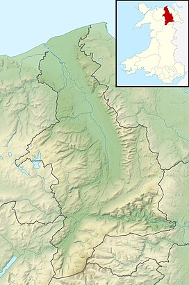
209:Show map of Denbighshire
324:Cadair Berwyn North Top
349:on the Nuttall list.
347:Cadair Berwyn New Top
424:"Moel Sych location"
307:[mɔi̯lsɨːχ]
146:English translation
121: /
402:hill-bagging.co.uk
125:52.8761°N 3.3885°W
41:Highest point
296:
295:
242:Show map of Wales
239:Moel Sych (Wales)
507:
480:Hewitts of Wales
452:
441:
435:
434:
432:
430:
419:
413:
412:
410:
408:
394:
385:
384:
382:
380:
366:
309:
304:
276:
256:
243:
229:
228:
222:
210:
186:
185:
179:
154:Language of name
136:
135:
133:
132:
131:
130:52.8761; -3.3885
126:
122:
119:
118:
117:
114:
81:
80:
33:
21:
515:
514:
510:
509:
508:
506:
505:
504:
470:
469:
461:
456:
455:
442:
438:
428:
426:
421:
420:
416:
406:
404:
396:
395:
388:
378:
376:
374:opentopomap.org
368:
367:
363:
358:
331:Montgomeryshire
302:
272:
254:
248:
247:
246:
245:
244:
241:
240:
237:
236:
235:
234:
230:
213:
212:
211:
208:
207:
194:
193:
192:
191:
187:
129:
127:
123:
120:
115:
112:
110:
108:
107:
75:
36:
17:
12:
11:
5:
513:
511:
503:
502:
497:
492:
487:
482:
472:
471:
468:
467:
460:
459:External links
457:
454:
453:
436:
414:
386:
360:
359:
357:
354:
339:Merionethshire
314:in north east
294:
293:
284:
278:
277:
270:
264:
263:
258:
250:
249:
238:
232:
231:
224:
223:
217:
216:
215:
214:
195:
189:
188:
181:
180:
174:
173:
172:
171:
170:
169:
166:
165:
161:
160:
155:
151:
150:
147:
143:
142:
138:
137:
105:
99:
98:
89:
83:
82:
69:
63:
62:
59:
53:
52:
49:
43:
42:
38:
37:
34:
26:
25:
15:
13:
10:
9:
6:
4:
3:
2:
512:
501:
498:
496:
493:
491:
488:
486:
483:
481:
478:
477:
475:
466:
463:
462:
458:
450:
449:1-85284-304-7
446:
440:
437:
425:
418:
415:
403:
399:
393:
391:
387:
375:
371:
365:
362:
355:
353:
350:
348:
342:
340:
336:
332:
327:
325:
321:
317:
313:
312:Cadair Berwyn
308:
300:
291:
288:
285:
283:
279:
275:
271:
269:
265:
262:
259:
257:
251:
221:
206:
202:
198:
178:
167:
162:
159:
156:
152:
148:
144:
139:
134:
106:
104:
100:
97:
93:
90:
88:
84:
79:
73:
72:Cadair Berwyn
70:
68:
64:
60:
58:
54:
50:
48:
44:
39:
32:
27:
22:
19:
439:
427:. Retrieved
417:
405:. Retrieved
401:
377:. Retrieved
373:
364:
351:
346:
343:
335:Denbighshire
328:
320:Berwyn range
298:
297:
289:
261:Berwyn range
255:Parent range
197:Denbighshire
18:
398:"Moel Sych"
128: /
103:Coordinates
67:Parent peak
474:Categories
356:References
303:pronounced
290:Landranger
113:52°52′34″N
57:Prominence
299:Moel Sych
233:Moel Sych
190:Moel Sych
164:Geography
116:3°23′19″W
47:Elevation
24:Moel Sych
490:Nuttalls
282:Topo map
274:SJ071323
149:dry hill
429:6 March
407:13 June
379:13 June
268:OS grid
96:Nuttall
87:Listing
447:
141:Naming
92:Hewitt
74:
316:Wales
205:Wales
201:Powys
158:Welsh
445:ISBN
431:2015
422:OS.
409:2023
381:2023
337:and
292:125
476::
400:.
389:^
372:.
333:,
326:.
287:OS
203:,
199:/
94:,
451:.
433:.
411:.
383:.
301:(
Text is available under the Creative Commons Attribution-ShareAlike License. Additional terms may apply.