54:
676:
42:
441:
In the CDP, the population was spread out, with 13.8% under the age of 18, 2.0% from 18 to 24, 21.1% from 25 to 44, 38.2% from 45 to 64, and 25.0% who were 65 years of age or older. The median age was 53 years. For every 100 females, there were 78.8 males. For every 100 females age 18 and over, there
437:
living together, 7.4% had a female householder with no husband present, and 43.2% were non-families. 37.0% of all households were made up of individuals, and 19.8% had someone living alone who was 65 years of age or older. The average household size was 1.88 and the average family size was 2.39.
53:
329:
by
Monomoscoy Road, which crosses tidal marshes to the northeast. A portion of the CDP is on the Cape Cod mainland, bordered on the north by Amy Brown Road; it is therefore technically not a true island. Neighboring CDPs, all in the town of Mashpee, are
1121:
612:
445:
The median income for a household in the CDP was $ 37,589, and the median income for a family was $ 34,444. Males had a median income of $ 36,250 versus $ 18,333 for females. The
325:(41.569951, -70.504593). It is bordered by the tidal Little River and Hamblin Pond to the northwest and by the Great River to the southeast, and is connected to the mainland of
405:
1136:
1126:
771:
605:
75:
598:
495:
655:
297:
245:
418:
was 244.5/km (625.6/mi). There were 152 housing units at an average density of 244.5/km (625.6/mi). The racial makeup of the CDP was 97.37%
993:
255:
981:
906:
901:
590:
129:
881:
622:
470:
279:
220:
134:
59:
1131:
926:
331:
1073:
686:
1063:
1033:
936:
916:
876:
861:
841:
831:
786:
521:
423:
41:
1091:
1068:
1058:
1043:
971:
961:
956:
886:
871:
826:
816:
796:
1078:
1023:
946:
931:
851:
846:
821:
801:
791:
781:
741:
573:
525:
346:
1048:
1003:
951:
896:
866:
811:
806:
339:
1053:
1018:
1013:
998:
966:
836:
665:
644:
499:
383:
1038:
941:
756:
107:
921:
911:
891:
761:
746:
721:
701:
335:
271:
32:
433:
There were 81 households, out of which 16.0% had children under the age of 18 living with them, 46.9% were
1028:
736:
731:
726:
716:
706:
275:
146:
1008:
711:
696:
1098:
751:
230:
496:"Geographic Identifiers: 2010 Demographic Profile Data (G001): Monomoscoy Island CDP, Massachusetts"
427:
419:
415:
446:
141:
349:, the Monomoscoy Island CDP has a total area of 0.23 square miles (0.6 km), all land.
414:
of 2000, there were 152 people, 81 households, and 46 families residing in the CDP. The
1115:
283:
122:
63:
450:
637:
547:
117:
312:
299:
90:
77:
294:
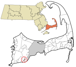
Monomoscoy Island is located in the southern part of the town of
Mashpee at
286:, United States. At the 2010 census, the CDP had a total population of 147.
211:
434:
326:
411:
449:
for the island was $ 19,927. None of the population were below the
237:
216:
594:
1122:
Census-designated places in
Barnstable County, Massachusetts
674:
569:
498:. U.S. Census Bureau, American Factfinder. Archived from
18:
406:
980:
770:
685:
654:
254:
244:
227:
210:
202:
194:
189:
181:
173:
165:
157:
152:
140:
128:
116:
106:
23:
606:
490:
488:
8:
613:
599:
591:
522:"US Gazetteer files: 2010, 2000, and 1990"
356:
20:
1137:Populated coastal places in Massachusetts
1127:Census-designated places in Massachusetts
342:CDP to the east, across the Great River.
462:
338:to the northwest, and a portion of the
243:
209:
188:
180:
151:
105:
70:
50:
38:
376:
334:to the west across the Little River,
253:
226:
201:
193:
172:
164:
156:
139:
127:
115:
7:
177:0.00 sq mi (0.00 km)
169:0.23 sq mi (0.60 km)
161:0.23 sq mi (0.60 km)
621:Municipalities and communities of
548:"Census of Population and Housing"
366:
14:
624:Barnstable County, Massachusetts
52:
40:
25:Monomoscoy Island, Massachusetts
1:
473:. United States Census Bureau
206:599.14/sq mi (231.82/km)
574:United States Census Bureau
526:United States Census Bureau
471:"2020 U.S. Gazetteer Files"
347:United States Census Bureau
1153:
403:
1087:
672:
635:
397:
382:
375:
370:
365:
362:
71:
51:
39:
30:
272:census-designated place
33:Census-designated place
1132:Mashpee, Massachusetts
679:
678:
570:"U.S. Census website"
398:U.S. Decennial Census
358:Historical population
313:41.57000°N 70.50472°W
274:(CDP) in the town of
229: • Summer (
91:41.57000°N 70.50472°W
1100:United States portal
1093:Massachusetts portal
502:on February 12, 2020
203: • Density
185:7 ft (2 m)
528:. February 12, 2011
359:
318:41.57000; -70.50472
309: /
96:41.57000; -70.50472
87: /
994:Barnstable Village
907:Provincetown (CDP)
902:Popponesset Island
680:
416:population density
357:
195: • Total
174: • Water
158: • Total
1109:
1108:
882:Northwest Harwich
857:Monomoscoy Island
447:per capita income
442:were 79.5 males.
402:
401:
345:According to the
280:Barnstable County
268:Monomoscoy Island
265:
264:
166: • Land
62:and the state of
60:Barnstable County
46:Monomoscoy Island
1144:
1101:
1094:
986:
927:Seconsett Island
774:
689:
677:
658:
647:
640:
630:
625:
615:
608:
601:
592:
585:
584:
582:
580:
566:
560:
559:
557:
555:
544:
538:
537:
535:
533:
518:
512:
511:
509:
507:
492:
483:
482:
480:
478:
467:
378:
373:
368:
360:
332:Seconsett Island
324:
323:
321:
320:
319:
314:
310:
307:
306:
305:
302:
234:
102:
101:
99:
98:
97:
92:
88:
85:
84:
83:
80:
56:
44:
21:
1152:
1151:
1147:
1146:
1145:
1143:
1142:
1141:
1112:
1111:
1110:
1105:
1099:
1092:
1083:
1074:West Barnstable
984:
982:
976:
772:
766:
687:
681:
675:
670:
656:
650:
645:
638:
631:
628:
623:
619:
589:
588:
578:
576:
568:
567:
563:
553:
551:
546:
545:
541:
531:
529:
520:
519:
515:
505:
503:
494:
493:
486:
476:
474:
469:
468:
464:
459:
435:married couples
424:Native American
408:
371:
355:
317:
315:
311:
308:
303:
300:
298:
296:
295:
292:
228:
95:
93:
89:
86:
81:
78:
76:
74:
73:
67:
47:
35:
26:
19:
12:
11:
5:
1150:
1148:
1140:
1139:
1134:
1129:
1124:
1114:
1113:
1107:
1106:
1104:
1103:
1096:
1088:
1085:
1084:
1082:
1081:
1076:
1071:
1066:
1064:Sagamore Beach
1061:
1056:
1051:
1046:
1041:
1036:
1034:Marstons Mills
1031:
1026:
1021:
1016:
1011:
1006:
1001:
996:
990:
988:
978:
977:
975:
974:
969:
964:
959:
954:
949:
944:
939:
937:South Yarmouth
934:
929:
924:
919:
917:Sandwich (CDP)
914:
909:
904:
899:
894:
889:
884:
879:
877:North Falmouth
874:
869:
864:
862:Monument Beach
859:
854:
849:
844:
842:Harwich Center
839:
834:
832:Falmouth (CDP)
829:
824:
819:
814:
809:
804:
799:
794:
789:
787:Brewster (CDP)
784:
778:
776:
768:
767:
765:
764:
759:
754:
749:
744:
739:
734:
729:
724:
719:
714:
709:
704:
699:
693:
691:
683:
682:
673:
671:
669:
668:
662:
660:
652:
651:
636:
633:
632:
620:
618:
617:
610:
603:
595:
587:
586:
561:
539:
513:
484:
461:
460:
458:
455:
400:
399:
395:
394:
391:
389:
386:
380:
379:
374:
369:
364:
354:
351:
291:
288:
263:
262:
259:
252:
251:
248:
242:
241:
235:
225:
224:
214:
208:
207:
204:
200:
199:
196:
192:
191:
187:
186:
183:
179:
178:
175:
171:
170:
167:
163:
162:
159:
155:
154:
150:
149:
144:
138:
137:
132:
126:
125:
120:
114:
113:
110:
104:
103:
69:
68:
57:
49:
48:
45:
37:
36:
31:
28:
27:
24:
17:
13:
10:
9:
6:
4:
3:
2:
1149:
1138:
1135:
1133:
1130:
1128:
1125:
1123:
1120:
1119:
1117:
1102:
1097:
1095:
1090:
1089:
1086:
1080:
1077:
1075:
1072:
1070:
1069:South Harwich
1067:
1065:
1062:
1060:
1059:Pleasant Lake
1057:
1055:
1052:
1050:
1047:
1045:
1044:North Harwich
1042:
1040:
1037:
1035:
1032:
1030:
1027:
1025:
1022:
1020:
1017:
1015:
1012:
1010:
1007:
1005:
1002:
1000:
997:
995:
992:
991:
989:
987:
979:
973:
972:Yarmouth Port
970:
968:
965:
963:
962:West Yarmouth
960:
958:
957:West Falmouth
955:
953:
950:
948:
945:
943:
940:
938:
935:
933:
930:
928:
925:
923:
920:
918:
915:
913:
910:
908:
905:
903:
900:
898:
895:
893:
890:
888:
887:Orleans (CDP)
885:
883:
880:
878:
875:
873:
872:North Eastham
870:
868:
865:
863:
860:
858:
855:
853:
850:
848:
845:
843:
840:
838:
835:
833:
830:
828:
827:East Sandwich
825:
823:
820:
818:
817:East Falmouth
815:
813:
810:
808:
805:
803:
800:
798:
797:Chatham (CDP)
795:
793:
790:
788:
785:
783:
780:
779:
777:
775:
769:
763:
760:
758:
755:
753:
750:
748:
745:
743:
740:
738:
735:
733:
730:
728:
725:
723:
720:
718:
715:
713:
710:
708:
705:
703:
700:
698:
695:
694:
692:
690:
684:
667:
664:
663:
661:
659:
653:
649:
648:
641:
634:
629:United States
626:
616:
611:
609:
604:
602:
597:
596:
593:
575:
571:
565:
562:
549:
543:
540:
527:
523:
517:
514:
501:
497:
491:
489:
485:
472:
466:
463:
456:
454:
452:
448:
443:
439:
436:
431:
429:
425:
421:
417:
413:
407:
396:
392:
390:
387:
385:
381:
361:
352:
350:
348:
343:
341:
337:
333:
328:
322:
289:
287:
285:
284:Massachusetts
281:
277:
273:
269:
260:
257:
249:
247:
239:
236:
232:
222:
221:Eastern (EST)
218:
215:
213:
205:
197:
184:
176:
168:
160:
148:
145:
143:
136:
133:
131:
124:
123:Massachusetts
121:
119:
112:United States
111:
109:
100:
72:Coordinates:
65:
64:Massachusetts
61:
55:
43:
34:
29:
22:
16:
1079:West Harwich
947:West Chatham
932:South Dennis
856:
852:Mashpee Neck
847:Harwich Port
822:East Harwich
802:Dennis (CDP)
792:Buzzards Bay
782:Bourne (CDP)
742:Provincetown
643:
577:. Retrieved
564:
552:. Retrieved
550:. Census.gov
542:
530:. Retrieved
516:
506:December 10,
504:. Retrieved
500:the original
475:. Retrieved
465:
451:poverty line
444:
440:
432:
426:, and 1.32%
409:
353:Demographics
344:
293:
267:
266:
58:Location in
15:
1049:North Truro
1024:Hyannisport
1004:Centerville
952:West Dennis
897:Popponesset
867:New Seabury
812:East Dennis
807:Dennis Port
639:County seat
579:January 31,
340:New Seabury
316: /
94: /
1116:Categories
1054:Osterville
1019:Hatchville
1014:Craigville
999:Bournedale
967:Woods Hole
837:Forestdale
666:Barnstable
646:Barnstable
457:References
410:As of the
404:See also:
304:70°30′17″W
301:41°34′12″N
258:feature ID
190:Population
135:Barnstable
82:70°30′17″W
79:41°34′12″N
1039:Menauhant
942:Teaticket
757:Wellfleet
532:April 23,
290:Geography
246:FIPS code
212:Time zone
182:Elevation
985:villages
922:Seabrook
912:Sagamore
892:Pocasset
762:Yarmouth
747:Sandwich
722:Falmouth
702:Brewster
422:, 1.32%
336:Seabrook
327:Cape Cod
250:25-41960
1029:Hyannis
737:Orleans
732:Mashpee
727:Harwich
717:Eastham
707:Chatham
554:June 4,
477:May 21,
276:Mashpee
261:1877296
147:Mashpee
108:Country
1009:Cotuit
712:Dennis
697:Bourne
412:census
363:Census
130:County
983:Other
752:Truro
688:Towns
428:Asian
420:White
270:is a
240:(EDT)
238:UTC-4
217:UTC-5
118:State
773:CDPs
657:City
581:2008
556:2016
534:2011
508:2013
479:2022
384:2020
372:Note
367:Pop.
256:GNIS
153:Area
142:Town
388:139
278:in
231:DST
198:139
1118::
642::
627:,
572:.
524:.
487:^
453:.
430:.
377:%±
282:,
614:e
607:t
600:v
583:.
558:.
536:.
510:.
481:.
393:—
233:)
223:)
219:(
66:.
Text is available under the Creative Commons Attribution-ShareAlike License. Additional terms may apply.