50:
372:
918:
86:
122:
198:
497:
were approved for, but did not receive, Covid recovery funding. Tony Novak CPA relocated his office to Money Island and rebranded the combined operations under the trade name
Nantuxent Group in an attempt to help with recovery. The marina, bait shop, charter boats, boat rental and crab business remain closed to the public at the end of the 2022 season. As of November 2022, Money Island had less than 5 full time year-round residents.
219:
129:
93:
57:
575:
496:
The small Money Island community suffered significant losses during Covid years of 2020 and 2021 including the death of five key members and long term disability of others. Looting and storm damage left the infrastructure in poor condition. The few small fishery businesses operating at Money Island
493:. The book featured the story of Tony Novak in his efforts to find sustainability for the community. Since much of the original story copy was trimmed during editing, Novak proposed a follow-up publication called "After the Drowning" that is in early stage production now.
436:
Money Island remains the second most important seafood landing port in southern New Jersey. The Money Island Marina and more than a dozen seafood harvesters or aquaculture businesses remain, with estimated annual sales of about $ 20 million. Products include
1327:
406:. The road that led to the development of Money Island was constructed in the late 1930s. In the 1940s, the first homes were constructed in the community. The community is located on the shore of the
1317:
468:
As of June 2016, the number of full-time residents had dropped below 20, and fewer than 10 of its original 40+ houses were occupied. A partnership of non-profit organizations—including
846:
49:
1322:
975:
970:
485:
426:
985:
980:
1332:
1088:
1018:
839:
1184:
1063:
85:
614:
347:
121:
157:
1239:
1139:
832:
1000:
473:
756:
1307:
605:
359:
990:
781:
824:
371:
1038:
995:
955:
610:
1204:
1098:
960:
383:
231:
660:
856:
395:
236:
70:
1043:
678:
664:
636:
480:—are engaged in shoreline-stabilization research projects, attempting to arrest the erosion impact of rising waters.
1179:
1169:
1149:
1118:
1103:
1053:
965:
391:
248:
1277:
1023:
538:
506:
1312:
1093:
1078:
1033:
189:
600:
1189:
1154:
1123:
1108:
1010:
387:
35:
1254:
1244:
1229:
1219:
1058:
1028:
469:
425:. Local opinions have been divided regarding participation in the Blue Acres buy-out program, part of the
1214:
1194:
1164:
1159:
1083:
1073:
947:
902:
897:
878:
243:
704:
1284:
1249:
1234:
1224:
1113:
929:
907:
332:
1144:
1068:
1048:
1174:
1128:
937:
730:
477:
889:
322:
648:
352:
446:
430:
422:
411:
462:
442:
418:
339:
318:
1301:
632:
203:
407:
390:(CDP) that is the smallest and most remote of five rural communities that make up
757:"Neighbors at odds over buy-outs in bayshore villages in Cumberland County, N.J."
661:
State of New Jersey Census
Designated Places - BVP20 - Data as of January 1, 2020
871:
806:
465:(for medical research). Horseshoe crab harvesting was discontinued after 2016.
403:
399:
224:
211:
106:
782:"On New Jersey's Bayshore, Waiting For A Post-Sandy Recovery That Never Came"
172:
159:
313:
1268:‡This populated place also has portions in an adjacent county or counties
450:
917:
414:. Its location may be described as the southwest corner of New Jersey.
438:
417:
Money Island is a low-income community which has been devastated by
454:
370:
828:
458:
916:
679:"Event Review: The Drowning of Money Island by Andrew Lewis"
490:
780:
Kaufman, Alexander C; D’Angelo, Chris (October 28, 2017).
1328:
Census-designated places in
Cumberland County, New Jersey
651:, Missouri Census Data Center. Accessed June 9, 2023.
16:
Populated place in
Cumberland County, New Jersey, US
1263:
1203:
1009:
946:
928:
888:
472:, BaySave, a New Jersey Nonprofit Corporation, the
358:
346:
329:
312:
304:
296:
291:
283:
275:
267:
259:
254:
242:
230:
210:
188:
26:
633:Census Data Explorer: Money Island CDP, New Jersey
1318:Populated places in Cumberland County, New Jersey
427:New Jersey Department of Environmental Protection
921:Map of New Jersey highlighting Cumberland County
840:
8:
628:
626:
624:
731:"Environmental Justice for Money Island NJ"
847:
833:
825:
511:
483:Beacon Publishing Group released the book
23:
75:Show map of Cumberland County, New Jersey
1323:Unincorporated communities in New Jersey
615:United States Department of the Interior
703:Gooding-Call, Anna (December 1, 2019).
567:
345:
311:
290:
282:
253:
187:
152:
41:
1333:Census-designated places in New Jersey
705:"Review: The Drowning of Money Island"
677:Garczynski, David (October 26, 2019).
649:Geographic Codes Lookup for New Jersey
601:"Money Island Census Designated Place"
595:
593:
531:
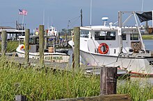
375:Commercial boat docks at Money Island
357:
328:
303:
295:
274:
266:
258:
241:
229:
209:
21:Census-designated place in New Jersey
7:
474:Partnership for the Delaware Estuary
128:
92:
56:
606:Geographic Names Information System
279:0.07 sq mi (0.17 km)
271:0.16 sq mi (0.42 km)
263:0.23 sq mi (0.59 km)
855:Municipalities and communities of
807:"Census of Population and Housing"
521:
14:
729:Novak, Tony (February 18, 2019).
755:Crimmins, Peter (July 8, 2014).
576:"ArcGIS REST Services Directory"
217:
196:
127:
120:
91:
84:
55:
48:
611:United States Geological Survey
1:
858:Cumberland County, New Jersey
578:. United States Census Bureau
144:Show map of the United States
141:Location in the United States
667:. Accessed December 1, 2022.
486:The Drowning of Money Island
308:134.97/sq mi (51.99/km)
665:United States Census Bureau
637:United States Census Bureau
489:in November 2019 by author
1349:
1308:Downe Township, New Jersey
1273:
914:
869:
639:. Accessed June 15, 2023.
552:
537:
530:
525:
520:
517:
509:, the population was 22.
507:2020 United States census
153:
42:
33:
410:on the southern side of
384:unincorporated community
28:Money Island, New Jersey
388:census-designated place
36:Census-designated place
922:
470:The Nature Conservancy
376:
111:Show map of New Jersey
920:
553:U.S. Decennial Census
513:Historical population
374:
331: • Summer (
1286:United States portal
305: • Density
287:0 ft (0 m)
1039:Cumberland-Hesstown
514:
169: /
1099:Lakeside-Beebe Run
923:
512:
478:Rutgers University
377:
297: • Total
276: • Water
260: • Total
1295:
1294:
1279:New Jersey portal
559:
558:
396:Cumberland County
369:
368:
268: • Land
173:39.284°N 75.237°W
71:Cumberland County
1340:
1287:
1280:
1044:Deerfield Street
919:
881:
874:
864:
859:
849:
842:
835:
826:
819:
818:
816:
814:
803:
797:
796:
794:
792:
777:
771:
770:
768:
766:
752:
746:
745:
743:
741:
726:
720:
719:
717:
715:
700:
694:
693:
691:
689:
683:Columbia Journal
674:
668:
658:
652:
646:
640:
630:
619:
618:
597:
588:
587:
585:
583:
572:
533:
528:
523:
515:
447:soft-shell crabs
336:
223:
221:
220:
206:
202:
200:
199:
184:
183:
181:
180:
179:
174:
170:
167:
166:
165:
162:
145:
131:
130:
124:
112:
95:
94:
88:
76:
59:
58:
52:
24:
1348:
1347:
1343:
1342:
1341:
1339:
1338:
1337:
1313:Managed retreat
1298:
1297:
1296:
1291:
1285:
1278:
1269:
1259:
1206:
1199:
1005:
1001:Upper Deerfield
942:
924:
912:
884:
879:
872:
865:
862:
857:
853:
823:
822:
812:
810:
805:
804:
800:
790:
788:
779:
778:
774:
764:
762:
754:
753:
749:
739:
737:
728:
727:
723:
713:
711:
702:
701:
697:
687:
685:
676:
675:
671:
659:
655:
647:
643:
631:
622:
599:
598:
591:
581:
579:
574:
573:
569:
564:
554:
526:
503:
491:Andrew S. Lewis
463:horseshoe crabs
443:blue claw crabs
431:managed retreat
423:Hurricane Sandy
412:Nantuxent Creek
330:
218:
216:
197:
195:
194:
178:39.284; -75.237
177:
175:
171:
168:
163:
160:
158:
156:
155:
149:
148:
147:
146:
143:
142:
139:
138:
137:
136:
132:
115:
114:
113:
110:
109:
103:
102:
101:
100:
96:
79:
78:
77:
74:
73:
67:
66:
65:
64:
60:
38:
29:
22:
17:
12:
11:
5:
1346:
1344:
1336:
1335:
1330:
1325:
1320:
1315:
1310:
1300:
1299:
1293:
1292:
1290:
1289:
1282:
1274:
1271:
1270:
1267:
1265:
1261:
1260:
1258:
1257:
1252:
1247:
1242:
1237:
1232:
1227:
1222:
1217:
1211:
1209:
1201:
1200:
1198:
1197:
1192:
1187:
1182:
1180:Sheppards Mill
1177:
1172:
1170:Seabrook Farms
1167:
1162:
1157:
1152:
1150:Port Elizabeth
1147:
1142:
1137:
1132:
1126:
1121:
1116:
1111:
1106:
1104:Laurel Heights
1101:
1096:
1091:
1086:
1081:
1076:
1071:
1066:
1061:
1056:
1054:Dividing Creek
1051:
1046:
1041:
1036:
1031:
1026:
1021:
1019:Arrowhead Lake
1015:
1013:
1007:
1006:
1004:
1003:
998:
993:
988:
983:
978:
973:
968:
963:
958:
952:
950:
944:
943:
941:
940:
934:
932:
926:
925:
915:
913:
911:
910:
905:
900:
894:
892:
886:
885:
870:
867:
866:
854:
852:
851:
844:
837:
829:
821:
820:
798:
772:
747:
721:
709:Toward Freedom
695:
669:
653:
641:
620:
589:
566:
565:
563:
560:
557:
556:
550:
549:
546:
544:
541:
535:
534:
529:
524:
519:
502:
499:
429:'s process of
419:sea level rise
392:Downe Township
367:
366:
363:
356:
355:
350:
344:
343:
337:
327:
326:
316:
310:
309:
306:
302:
301:
298:
294:
293:
289:
288:
285:
281:
280:
277:
273:
272:
269:
265:
264:
261:
257:
256:
252:
251:
246:
240:
239:
234:
228:
227:
214:
208:
207:
192:
186:
185:
151:
150:
140:
134:
133:
126:
125:
119:
118:
117:
116:
104:
98:
97:
90:
89:
83:
82:
81:
80:
68:
62:
61:
54:
53:
47:
46:
45:
44:
43:
40:
39:
34:
31:
30:
27:
20:
15:
13:
10:
9:
6:
4:
3:
2:
1345:
1334:
1331:
1329:
1326:
1324:
1321:
1319:
1316:
1314:
1311:
1309:
1306:
1305:
1303:
1288:
1283:
1281:
1276:
1275:
1272:
1266:
1262:
1256:
1253:
1251:
1248:
1246:
1243:
1241:
1238:
1236:
1233:
1231:
1228:
1226:
1223:
1221:
1218:
1216:
1213:
1212:
1210:
1208:
1202:
1196:
1193:
1191:
1188:
1186:
1183:
1181:
1178:
1176:
1173:
1171:
1168:
1166:
1163:
1161:
1158:
1156:
1153:
1151:
1148:
1146:
1143:
1141:
1138:
1136:
1133:
1130:
1127:
1125:
1122:
1120:
1117:
1115:
1112:
1110:
1107:
1105:
1102:
1100:
1097:
1095:
1092:
1090:
1087:
1085:
1082:
1080:
1077:
1075:
1072:
1070:
1067:
1065:
1062:
1060:
1057:
1055:
1052:
1050:
1047:
1045:
1042:
1040:
1037:
1035:
1032:
1030:
1027:
1025:
1024:Carlls Corner
1022:
1020:
1017:
1016:
1014:
1012:
1008:
1002:
999:
997:
994:
992:
991:Maurice River
989:
987:
984:
982:
979:
977:
974:
972:
969:
967:
964:
962:
959:
957:
954:
953:
951:
949:
945:
939:
936:
935:
933:
931:
927:
909:
906:
904:
901:
899:
896:
895:
893:
891:
887:
883:
882:
875:
868:
863:United States
860:
850:
845:
843:
838:
836:
831:
830:
827:
808:
802:
799:
787:
783:
776:
773:
761:
758:
751:
748:
736:
732:
725:
722:
710:
706:
699:
696:
684:
680:
673:
670:
666:
662:
657:
654:
650:
645:
642:
638:
634:
629:
627:
625:
621:
616:
612:
608:
607:
602:
596:
594:
590:
577:
571:
568:
561:
551:
547:
545:
542:
540:
536:
516:
510:
508:
500:
498:
494:
492:
488:
487:
481:
479:
475:
471:
466:
464:
460:
456:
452:
448:
444:
440:
434:
432:
428:
424:
420:
415:
413:
409:
405:
401:
397:
393:
389:
385:
381:
373:
364:
361:
354:
351:
349:
341:
338:
334:
324:
323:Eastern (EST)
320:
317:
315:
307:
299:
286:
278:
270:
262:
250:
247:
245:
238:
235:
233:
226:
215:
213:
205:
204:United States
193:
191:
182:
154:Coordinates:
123:
108:
87:
72:
51:
37:
32:
25:
19:
1135:Money Island
1134:
1094:Heislerville
1079:Gandys Beach
1034:Centre Grove
877:
811:. Retrieved
809:. Census.gov
801:
789:. Retrieved
785:
775:
763:. Retrieved
759:
750:
738:. Retrieved
734:
724:
712:. Retrieved
708:
698:
686:. Retrieved
682:
672:
656:
644:
604:
580:. Retrieved
570:
504:
501:Demographics
495:
484:
482:
467:
435:
416:
408:Delaware Bay
380:Money Island
379:
378:
135:Money Island
105:Location in
99:Money Island
69:Location in
63:Money Island
18:
1207:communities
1190:Sunset Lake
1185:Silver Lake
1155:Port Norris
1124:Mauricetown
1109:Laurel Lake
873:County seat
791:December 1,
765:December 1,
740:December 1,
714:December 1,
688:December 1,
582:October 11,
176: /
1302:Categories
1255:Springtown
1245:Sea Breeze
1230:Cumberland
1220:Buckshutem
1064:Dutch Neck
1059:Dorchester
1029:Cedarville
996:Stow Creek
956:Commercial
562:References
505:As of the
404:New Jersey
400:U.S. state
362:feature ID
292:Population
237:Cumberland
225:New Jersey
164:75°14′13″W
161:39°17′02″N
107:New Jersey
1264:Footnotes
1215:Bowentown
1195:West Park
1165:Rosenhayn
1160:Roadstown
1089:Greenwich
1084:Gouldtown
1074:Fortescue
976:Greenwich
971:Fairfield
961:Deerfield
948:Townships
903:Millville
898:Bridgeton
880:Bridgeton
348:FIPS code
340:UTC−04:00
319:UTC−05:00
314:Time zone
284:Elevation
244:Townships
1250:Seabrook
1235:Hesstown
1225:Cohansey
1119:Marlboro
1114:Leesburg
986:Lawrence
981:Hopewell
908:Vineland
786:HuffPost
451:menhaden
353:34-47006
1240:Jericho
1145:Othello
1140:Newport
1069:Fairton
1049:Delmont
930:Borough
813:June 4,
735:Baysave
439:oysters
398:in the
365:2806138
190:Country
1175:Seeley
1129:Milmay
938:Shiloh
890:Cities
518:Census
476:, and
382:is an
232:County
222:
201:
1205:Other
966:Downe
455:conch
342:(EDT)
249:Downe
212:State
1011:CDPs
815:2016
793:2019
767:2019
760:WHYY
742:2019
716:2019
690:2019
584:2022
555:2020
539:2020
527:Note
522:Pop.
461:and
459:eels
421:and
386:and
360:GNIS
255:Area
402:of
394:in
333:DST
1304::
876::
861:,
784:.
733:.
707:.
681:.
663:,
635:,
623:^
613:,
609:.
603:.
592:^
543:22
532:%±
457:,
453:,
449:,
445:,
441:,
433:.
300:22
1131:‡
848:e
841:t
834:v
817:.
795:.
769:.
744:.
718:.
692:.
617:.
586:.
548:—
335:)
325:)
321:(
Text is available under the Creative Commons Attribution-ShareAlike License. Additional terms may apply.