181:(ZNIEFF). Elevations range from 400 to 1,535 metres (1,312 to 5,036 ft). The ZNIEFF extends along the ridge from Monte Filetto (842 m) to the Rocher de Pietrapolo (1104 m). This main chain changes direction at Monte Tassu, where a secondary ridge line oriented to the north emerges, comprising Monte Maggiore (1102 m) and Monte Pietrapolo (1104 m). The main ridge line has eight peaks that exceed 1,100 m: Cima di Grimaseta: 1,509 metres (4,951 ft), Monte Asto: 1,535 metres (5,036 ft), Cima to i Muzzelli: 1,299 metres (4,262 ft), Punta di Paganella: 1,426 metres (4,678 ft), Monte Reghia di Pozzo: 1,469 metres (4,820 ft), Monte Sant'Angelo: 1,389 metres (4,557 ft), Monte Tassu: 1,372 metres (4,501 ft), Rocher de Pietrapolo: 1,104 metres (3,622 ft).
111:
489:
29:
477:
589:
645:
177:
168:
The Monte Astu massif has a main chain, the Serra di Tenda, and two secondary chains. The Serra di Tenda has all the highest peaks in the massif. It separates the Nebbio from the
572:
488:
71:
550:
565:
861:
854:
883:
558:
844:
785:
64:
888:
780:
110:
629:
476:
800:
614:
805:
790:
624:
825:
674:
634:
619:
820:
810:
795:
679:
609:
724:
830:
770:
659:
143:
815:
765:
704:
699:
877:
719:
669:
28:
775:
744:
739:
729:
714:
694:
462:
734:
709:
689:
664:
582:
450:
175:
Part of the massif covering 6,159 hectares (15,220 acres) has been designated a
122:
749:
684:
220:
157:
47:
532:
86:
73:
454:
169:
449:
The western part of the Monte Astu massif is drained to the north by the
458:
153:
126:
495:
130:
54:
644:
453:
which flows into the Gulf of Saint-Florent and to the south by the
554:
178:
Zone naturelle d'intérêt écologique, faunistique et floristique
152:) is a chain of mountains in the northeast of the island of
457:. The streams from the eastern sector flow either into the
498:
in front of the church of San
Quilico, Piève, Nebbio
758:
652:
597:
118:
102:
63:
53:
43:
38:
21:
537:Inventaire national du patrimoine naturel (INPN)
533:"ZNIEFF 940013187 Massif du Tenda et Monte Astu"
566:
8:
515:
573:
559:
551:
191:
18:
307:Monte Sant' Angelo (Monte Sant' Anghiuli)
508:
472:
7:
14:
156:, France. It takes its name from
643:
587:
487:
475:
109:
27:
1:
59:1,535 m (5,036 ft)
16:Chain of mountains in France
461:(to the north) or into the
905:
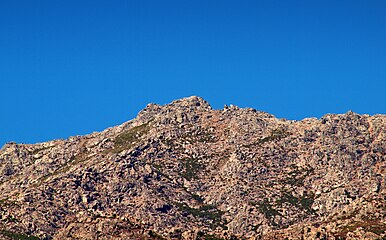
33:Monte Astu above Pietralba
839:
641:
200:
197:
194:
107:
26:
884:Mountains of Haute-Corse
482:The peak of Monte Astu
147:
273:Monte Reghia di Pozzo
189:The main peaks are,
160:, the highest peak.
149:Massif du Monte Astu
87:42.82806°N 9.38583°E
375:Monte di L'Alturaia
83: /
889:Massifs of Corsica
680:Cima di e Follicie
290:Punta di Paganella
39:Highest point
871:
870:
725:Monte San Petrone
630:Monte San Petrone
581:Landforms of the
442:
441:
341:Cima a i Muzzelli
256:Cima di Grimaseta
239:Petra San Ghiaccu
140:Monte Astu massif
136:
135:
92:42.82806; 9.38583
22:Monte Astu massif
896:
647:
592:
591:
590:
575:
568:
561:
552:
546:
545:
544:
519:
516:ZNIEFF 940013187
513:
491:
479:
465:(to the south).
192:
113:
98:
97:
95:
94:
93:
88:
84:
81:
80:
79:
76:
31:
19:
904:
903:
899:
898:
897:
895:
894:
893:
874:
873:
872:
867:
866:
835:
754:
660:Capo al Berdato
648:
639:
593:
588:
586:
579:
549:
542:
540:
531:
527:
522:
514:
510:
506:
499:
492:
483:
480:
471:
447:
187:
166:
114:
91:
89:
85:
82:
77:
74:
72:
70:
69:
34:
17:
12:
11:
5:
902:
900:
892:
891:
886:
876:
875:
869:
868:
865:
864:
859:
858:
857:
847:
841:
840:
837:
836:
834:
833:
828:
823:
818:
813:
808:
803:
798:
793:
788:
783:
778:
773:
768:
762:
760:
756:
755:
753:
752:
747:
742:
737:
732:
727:
722:
717:
712:
707:
702:
700:Monte Incudine
697:
692:
687:
682:
677:
672:
667:
662:
656:
654:
650:
649:
642:
640:
638:
637:
632:
627:
622:
617:
615:Monte Incudine
612:
607:
601:
599:
595:
594:
580:
578:
577:
570:
563:
555:
548:
547:
528:
526:
523:
521:
520:
507:
505:
502:
501:
500:
493:
486:
484:
481:
474:
470:
467:
446:
443:
440:
439:
436:
433:
430:
427:
423:
422:
419:
416:
413:
410:
406:
405:
402:
399:
396:
393:
389:
388:
385:
382:
379:
376:
372:
371:
368:
365:
362:
359:
358:Monte d'Oltari
355:
354:
351:
348:
345:
342:
338:
337:
334:
331:
328:
325:
321:
320:
317:
314:
311:
308:
304:
303:
300:
297:
294:
291:
287:
286:
283:
280:
277:
274:
270:
269:
266:
263:
260:
257:
253:
252:
249:
246:
243:
240:
236:
235:
232:
229:
226:
223:
217:
216:
213:
210:
207:
203:
202:
199:
196:
186:
183:
165:
162:
134:
133:
120:
116:
115:
108:
105:
104:
100:
99:
67:
61:
60:
57:
51:
50:
45:
41:
40:
36:
35:
32:
24:
23:
15:
13:
10:
9:
6:
4:
3:
2:
901:
890:
887:
885:
882:
881:
879:
863:
860:
856:
853:
852:
851:
848:
846:
843:
842:
838:
832:
829:
827:
824:
822:
819:
817:
814:
812:
809:
807:
806:Santo Stefano
804:
802:
799:
797:
794:
792:
791:San Colombano
789:
787:
784:
782:
781:Saint-Antoine
779:
777:
774:
772:
769:
767:
764:
763:
761:
757:
751:
748:
746:
743:
741:
738:
736:
733:
731:
728:
726:
723:
721:
720:Monte Rotondo
718:
716:
713:
711:
708:
706:
703:
701:
698:
696:
693:
691:
688:
686:
683:
681:
678:
676:
675:Cima a i Mori
673:
671:
670:Capu Tafunatu
668:
666:
663:
661:
658:
657:
655:
651:
646:
636:
633:
631:
628:
626:
625:Monte Rotondo
623:
621:
618:
616:
613:
611:
608:
606:
603:
602:
600:
596:
584:
576:
571:
569:
564:
562:
557:
556:
553:
538:
534:
530:
529:
524:
517:
512:
509:
503:
497:
490:
485:
478:
473:
468:
466:
464:
460:
456:
452:
444:
437:
434:
431:
428:
426:Monte Ambrica
425:
424:
420:
417:
414:
411:
408:
407:
403:
400:
397:
394:
391:
390:
386:
383:
380:
377:
374:
373:
369:
366:
363:
360:
357:
356:
352:
349:
346:
343:
340:
339:
335:
332:
329:
326:
323:
322:
318:
315:
312:
309:
306:
305:
301:
298:
295:
292:
289:
288:
284:
281:
278:
275:
272:
271:
267:
264:
261:
258:
255:
254:
250:
247:
244:
241:
238:
237:
233:
230:
227:
224:
222:
219:
218:
214:
211:
208:
205:
204:
193:
190:
184:
182:
180:
179:
173:
171:
163:
161:
159:
155:
151:
150:
145:
141:
132:
128:
124:
121:
117:
112:
106:
101:
96:
68:
66:
62:
58:
56:
52:
49:
46:
42:
37:
30:
25:
20:
855:Corse-du-Sud
849:
786:Sainte-Marie
745:Punta Minuta
740:Punta Artica
730:Monte Stello
715:Monte Renoso
695:Monte Grosso
635:Monte Stello
620:Monte Renoso
604:
541:, retrieved
536:
511:
448:
392:Monte Tevisi
188:
176:
174:
167:
148:
139:
137:
862:Waterbodies
801:Santa Lucia
796:San Quilico
735:Paglia Orba
710:Monte Padro
705:Monte d'Oro
690:Monte Cinto
665:Capu Biancu
610:Monte Cinto
585:department
583:Haute-Corse
539:(in French)
445:Hydrography
409:Monte Pruno
324:Monte Tassu
201:Prominence
123:Haute-Corse
90: /
65:Coordinates
878:Categories
750:San Parteo
685:Monte Astu
605:Monte Astu
543:2021-12-11
221:Monte Astu
158:Monte Astu
75:42°49′41″N
48:Monte Astu
850:Landforms
831:Vizzavona
771:Marsolino
455:Ostriconi
198:Elevation
170:Ostriconi
103:Geography
55:Elevation
845:Communes
172:valley.
164:Location
119:Location
78:9°23′9″E
816:Teghime
766:Bigorno
598:Massifs
525:Sources
496:menhirs
469:Gallery
459:Bevinco
154:Corsica
127:Corsica
826:Vergio
759:Passes
494:Three
429:1,063
412:1,150
395:1,150
378:1,271
361:1,290
344:1,299
327:1,372
310:1,389
293:1,426
276:1,469
259:1,509
242:1,512
234:3,488
231:1,063
225:1,535
212:meters
206:meters
144:French
131:France
821:Verde
811:Sorba
776:Prato
653:Peaks
504:Notes
451:Aliso
432:3,488
415:3,770
398:3,770
381:4,170
364:4,230
347:4,262
330:4,501
313:4,557
296:4,678
279:4,820
262:4,951
245:4,961
228:5,036
215:feet
185:Peaks
463:Golo
209:feet
195:Name
138:The
44:Peak
880::
535:,
438:0
435:0
421:0
418:0
404:0
401:0
387:0
384:0
370:0
367:0
353:0
350:0
336:0
333:0
319:0
316:0
302:0
299:0
285:0
282:0
268:0
265:0
251:0
248:0
146::
129:,
125:,
574:e
567:t
560:v
518:.
142:(
Text is available under the Creative Commons Attribution-ShareAlike License. Additional terms may apply.